Categories
Junior Mining Lion One Metals Precious Metals

Lion One Intersects 17.52 g/t Gold over 23.7m in Deep Zone 500 Drilling at Tuvatu Alkaline Gold Project in Fiji

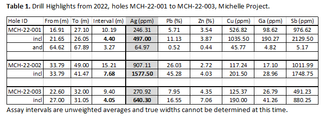
North Vancouver, British Columbia–(Newsfile Corp. – November 7, 2022) – Lion One Metals Limited (TSXV: LIO) (OTCQX: LOMLF) (ASX: LLO) (“Lion One” or the “Company”) is pleased to announce results from hole TUDDH 608 as part of its ongoing deep drill program in definition of the “500” zone. Exceptional results include 23.7 meters (m) averaging 17.52 g/t gold with a horizontal true width of 10.4m. Mineralized intervals are inclusive of several bonanza-grade intercepts. This hole is consistent with Lion One’s geological model of a robust Alkalic gold system with increasing gold grade at depth.

Highlights

A deep high-grade intercept of 17.52 g/t Au over 23.7m with 10.4m true width from TUDDH 608
Targeting intersection of TUG 141 (20.86 g/t Au over 76.9m) and TUDDH 601 (12.22 g/t Au over 54.9m)
Structural interpretation for a deep high grade feeder system taking shape in Zone 500

TUDDH 608 – select high grade intercepts

From mTo mIntercept mGrade g/t Au
594.5618.223.7017.89
594.5614.119.6021.16
596.7603.16.4042.58
596.7597.91.2085.10
599.8600.40.60108.31

Lion One Senior Vice President Exploration Sergio Cattalani commented “By drilling at a high angle across the TUG 141 (20.86 g/t gold over 76.9m) / TUDDH 601 (12.22 g/t Au over 54.9m) high-grade zone, TUDDH 608 was able to provide valuable information on the width and continuity of this zone. The outstanding results obtained of 17.52 g/t gold over 23.7m corresponds to a horizontal true width of 10.4m, which is approximately seven times the estimated average mining width, and at a grade that is nearly twice the average grade of the existing resource. The significance of this zone and its likely contribution to the increase in overall contained ounces cannot be overstated, as the extent of this zone may be much greater than previously thought. We are currently drilling several additional holes to test the possible plunge extent estimated by oriented core structural measurements. We will continue to report additional results as they become available.”

Hole TUDDH 608 (azimuth: 089°, dip: -64°), drilled from west to east, was designed drill across the high-grade zone identified in two directions by TUG 141 and TUDDH 601 (Figures 1, 2). With the completion of TUDDH 608 we can now better understand the true horizontal width and potential volume of the bonanza-grade feeder zone. The results are outstanding with 23.7m drilled width at 17.5 g/t gold, including 19.6m of 20.7 g/t gold (Figures 3-10). The horizontal true width of the zone at the drilled location is 10.4m (Figure 1). Lion One regards the confirmation of the high-grade feeder zone initially identified by TUG 141 and TUDDH 601 as transformational in that it confirms both continuity and implies extensive volume of the mineralized feeder zone below the current resource. Mineralization in TUDDH 608 extends from 594.5m to 618.2m (Table 1).

These results are part of ongoing exploration, infill, and grade-control drill programs. They complement the excellent results obtained by both the metallurgical and infill drill programs completed earlier this year and reported on October 4, 2022 Lion One Drills Exceptional High-Grade Intersections as Part of Metallurgical Drill Program, and February 23, 2022 Lion One Reports Additional High-Grade Intercepts, Completes Phase 1 Infill Drill Program at Tuvatu. The additional results from this on-going program reported here will be applied to the ongoing remodeling of the Tuvatu orebody that will inform the resource update and PEA scheduled for Q1 2023.

Lion One CEO Walter Berukoff commented “We look forward to further definition of the “Jewel box” dilatational feeder zone that we have been drilling out beneath the existing resource starting from surface at Tuvatu. This hole provides outstanding results for us as it continues to lend credence and proof-of-concept to the thesis of a deeper, very high-grade, feeder-style zone at depth. We continue to add enormous value to the mine as well as the critical exploration upside with the drill bit. We are defining what looks to be the next major high-grade discovery and world-class gold deposit right here in Fiji. We look forward to further results in very near future.”

Assay Data for TUDDH 608

Drill HoleEastingNorthingElevationAzimuthDipLength (m)
TUDDH 6081876280.43920472.4286.589-64678.1
Drill HoleFrom (m)To (m)Interval (m)Au (g/t)
TUDDH 60838.038.60.61.04
263.8264.40.60.79
285.1285.70.60.69
493.6493.90.33.08
503.2510.06.82.45
Including506.7507.30.610.50
511.2515.74.51.45
517.8518.10.31.09
519.3523.23.91.50
557.1557.70.69.09
Including557.1557.40.311.65
Including557.4557.70.36.52
559.2559.80.63.03
571.4572.61.29.42
Including571.4572.00.617.03
Including572.0572.60.61.80
576.5577.40.90.51
594.5618.223.717.89
Which Includes594.5614.119.621.16
Also Including596.7603.16.442.58
Including596.7597.91.285.10
Including597.9598.60.79.42
Including598.6598.90.38.38
Including598.9599.20.311.44
Including599.2599.50.36.98
Including599.5599.80.336.39
Including599.8600.40.6108.31
Including600.4600.70.321.69
Including600.7601.71.013.54
Including601.7602.20.523.21
Including602.5603.10.680.02
and603.1603.70.67.05
Including603.7604.00.311.98
Including606.0606.60.654.54
Including606.6607.20.612.00
Including607.2607.80.68.30
Including607.8608.40.629.57
Including609.3609.60.324.31
Including610.2610.80.610.85
Including610.8611.10.37.54
Including611.4612.10.745.02
Including612.1612.90.813.31
and612.9613.80.90.54
and613.8614.10.31.87
and614.1616.12.0<0.5
616.1618.22.14.26
Including616.1616.70.611.72
Including616.7617.50.81.87
Including617.5618.20.70.59
670.2670.50.31.05

Figure 1: Tuvatu Alkalic gold mine. Blue shapes are areas of known mineralization that define the current resource. Note the trifecta of holes that delineate, in 3 different orientations, the 10.4m true width of the “Jewel Box” high-grade zone (Brown =>10 g/t Au) which occurs within the larger high-grade 500 feeder zone

To view an enhanced version of this graphic, please visit:
https://images.newsfilecorp.com/files/2178/143271_01ab336bd4c69bc8_001full.jpg


Figure 2: Closer view of the lower portion of Figure 1, depicting theorientation of selected drill holes that define a coherent high-grade portion within the high-grade 500 Zone mineralization entirely below the current resource.

To view an enhanced version of this graphic, please visit:
https://images.newsfilecorp.com/files/2178/143271_01ab336bd4c69bc8_002full.jpg

Figure 3: TUDDH 608. Visible gold at 571.5m. Grade: 17.03 g/t Au

To view an enhanced version of this graphic, please visit:
https://images.newsfilecorp.com/files/2178/143271_01ab336bd4c69bc8_003full.jpg

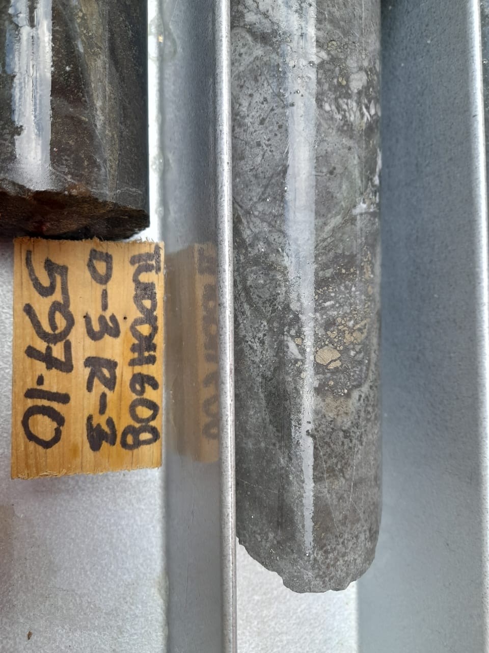
Figure 4: TUDDH 608. Mineralized Andesite core at 596.7-597.9m. Grade: 85.41 g/t Au over 1.2m

To view an enhanced version of this graphic, please visit:
https://images.newsfilecorp.com/files/2178/143271_01ab336bd4c69bc8_004full.jpg


Figure 5: TUDDH 608. Gold-bearing mm scale veins at 599.5m. Grade: 36.39 g/t Au

To view an enhanced version of this graphic, please visit:
https://images.newsfilecorp.com/files/2178/143271_01ab336bd4c69bc8_005full.jpg


Figure 6: TUDDH 608. Gold-bearing veins at 600.5m. Grade: 21.69 g/t Au

To view an enhanced version of this graphic, please visit:
https://images.newsfilecorp.com/files/2178/143271_01ab336bd4c69bc8_006full.jpg

Figure 7: TUDDH 608. Gold-bearing mm-scale veins at 600.8m. Grade: 13.54 g/t Au

To view an enhanced version of this graphic, please visit:
https://images.newsfilecorp.com/files/2178/143271_01ab336bd4c69bc8_007full.jpg

Figure 8: TUDDH 608. Visible gold at 602.6-603.0m within mm-scale vein. Grade: 80.02 g/t Au

To view an enhanced version of this graphic, please visit:
https://images.newsfilecorp.com/files/2178/143271_01ab336bd4c69bc8_008full.jpg


Figure 9: TUDDH 608. High-grade material hosted within mm-scale ladder vein at 606.5m. Grade: 54.54 g/t Au

To view an enhanced version of this graphic, please visit:
https://images.newsfilecorp.com/files/2178/143271_01ab336bd4c69bc8_009full.jpg


Figure 10: TUDDH 608. Visible gold in cut core. Grade: 45.02 g/t Au

To view an enhanced version of this graphic, please visit:
https://images.newsfilecorp.com/files/2178/143271_01ab336bd4c69bc8_010full.jpg

Qualified Person

In accordance with National Instrument 43-101 – Standards of Disclosure for Mineral Projects (“NI 43- 101”), Sergio Cattalani, P.Geo, Senior Vice President Exploration, is the Qualified Person for the Company and has reviewed and is responsible for the technical and scientific content of this news release.

QAQC Procedures

Lion One adheres to rigorous QAQC procedures above and beyond basic regulatory guidelines in conducting its sampling, drilling, testing, and analyses. The Company utilizes its own fleet of diamond drill rigs, using PQ, HQ and NQ sized drill core rods. Drill core is logged and split by Lion One personnel on site. Samples are delivered to and analyzed at the Company’s geochemical and metallurgical laboratory in Fiji. Duplicates of all samples with grades above 0.5 g/t Au are both re-assayed at Lion One’s lab and delivered to ALS Global Laboratories in Australia (ALS) for check assay determinations. All samples for all high-grade intercepts are sent to ALS for check assays. All samples are pulverized to 80% passing through 75 microns. Gold analysis is carried out using fire assay with an AA finish. Samples that have returned grades greater than 10.00 g/t Au are then re-analyzed by gravimetric method. For samples that return greater than 0.50 g/t Au, repeat fire assay runs are carried out and repeated until a result is obtained that is within 10% of the original fire assay run. Lion One’s laboratory can also assay for a range of 71 other elements through Inductively Coupled Plasma Optical Emission Spectrometry (ICP-OES), but currently focuses on a suite of 9 important pathfinder elements. All duplicate anomalous samples are sent to ALS labs in Townsville QLD and are analyzed by the same methods (Au-AA26, and Au-GRA22 where applicable). ALS also analyses 33 pathfinder elements by HF-HNO3-HClO4 acid digestion, HCl leach and ICP-AES (method ME-ICP61).

About Lion One Metals Limited

Lion One’s flagship asset is 100% owned, fully permitted high grade Tuvatu Alkaline Gold Project, located on the island of Viti Levu in Fiji. Lion One envisions a low-cost high-grade underground gold mining operation at Tuvatu coupled with exciting exploration upside inside its tenements covering the entire Navilawa Caldera, an underexplored yet highly prospective 7km diameter alkaline gold system. Lion One’s CEO Walter Berukoff leads an experienced team of explorers and mine builders and has owned or operated over 20 mines in 7 countries. As the founder and former CEO of Miramar Mines, Northern Orion, and La Mancha Resources, Walter is credited with building over $3 billion of value for shareholders.

On behalf of the Board of Directors
of Lion One Metals Limited

Walter Berukoff
Chairman and CEO

For further information
Contact Investor Relations

Toll Free (North America)
Tel: 1-855-805-1250
Email: info@liononemetals.com
Website: www.liononemetals.com

Neither the TSX Venture Exchange nor its Regulation Service Provider accepts responsibility for the adequacy or accuracy of this release.

This press release may contain statements that may be deemed to be “forward-looking statements” within the meaning of applicable Canadian securities legislation. All statements, other than statements of historical fact, included herein are forward looking information. Generally, forward-looking information may be identified by the use of forward-looking terminology such as “plans”, “expects” or “does not expect”, “proposed”, “is expected”, “budget”, “scheduled”, “estimates”, “forecasts”, “intends”, “anticipates” or “does not anticipate”, or “believes”, or variations of such words and phrases, or by the use of words or phrases which state that certain actions, events or results may, could, would, or might occur or be achieved. This forward-looking information reflects Lion One Metals Limited’s current beliefs and is based on information currently available to Lion One Metals Limited and on assumptions Lion One Metals Limited believes are reasonable. These assumptions include, but are not limited to, the actual results of exploration projects being equivalent to or better than estimated results in technical reports, assessment reports, and other geological reports or prior exploration results. Forward-looking information is subject to known and unknown risks, uncertainties and other factors that may cause the actual results, level of activity, performance or achievements of Lion One Metals Limited or its subsidiaries to be materially different from those expressed or implied by such forward-looking information. Such risks and other factors may include, but are not limited to: the stage development of Lion One Metals Limited, general business, economic, competitive, political and social uncertainties; the actual results of current research and development or operational activities; competition; uncertainty as to patent applications and intellectual property rights; product liability and lack of insurance; delay or failure to receive board or regulatory approvals; changes in legislation, including environmental legislation, affecting mining, timing and availability of external financing on acceptable terms; not realizing on the potential benefits of technology; conclusions of economic evaluations; and lack of qualified, skilled labour or loss of key individuals. Although Lion One Metals Limited has attempted to identify important factors that could cause actual results to differ materially from those contained in forward-looking information, there may be other factors that cause results not to be as anticipated, estimated or intended. Accordingly, readers should not place undue reliance on forward-looking information. Lion One Metals Limited does not undertake to update any forward-looking information, except in accordance with applicable securities laws.

To view the source version of this press release, please visit https://www.newsfilecorp.com/release/143271

Categories
Energy Junior Mining Precious Metals

Dolly Varden Silver Intersects 1.50m of 1,367 g/t Ag within 12.51 meters Grading 442 g/t Ag at Kitsol Vein

Vancouver, British Columbia–(Newsfile Corp. – November 7, 2022) – Dolly Varden Silver Corporation (TSXV: DV) (OTCQX: DOLLF) (the “Company” or “Dolly Varden“) is pleased to announce results from drilling at the Torbrit Resource area, including infill and step-out drilling within the Kitsol Vein zone.

The high-grade, potentially bulk-mineable Kitsol Vein continued to deliver outstanding, contiguous silver and base metal mineralization, where DV22-291 intersected 12.51m (8.88m true width) averaging 442 g/t Ag, 0.68% Pb and 0.42% Zn, including of 1,367 g/t Ag over 1.50m (1.07m true width), as an up-dip infill hole from previous high-grade intercepts.

Highlights include:

  • DV22-289: 979 g/t Ag over 0.49 meters true width, step out at Torbrit Main
  • DV22-291: 442 g/t Ag over 8.88 meters true width, infill at Kitsol
  • DV22-298: 372 g/t Ag over 10.78 meters true width, up-dip extension at Kitsol
  • DV22-308: 297 g/t Ag over 6.59 meters true width, step out at Torbrit Main
  • DV22-312: 585 g/t Ag over 3.30 meters true width, step out at Torbrit Main

“In addition to discovery-focused exploration drilling, Dolly Varden Silver has been prioritizing resource expansion and upgrading at the Torbrit/Kitsol, Wolf, Homestake Main and Homestake Silver deposits. We continue to encounter wide, potentially bulk-mineable vein-hosted silver mineralization at Kitsol, and expect to announce significant drill results from the other resource areas in the next few weeks,” said Shawn, Khunkhun, President and CEO.

The 2022 exploration drill program on the Kitsault Valley trend has completed 37,061m in 108 drill holes. Drilling wrapped up in mid-October, with the majority of assays still pending. Additionally, ground geophysics, surface mapping and prospecting work were completed, evaluating historic prospects and identifying new silver and gold occurrences.

Torbrit Main and North Deposits consist of distinctive stratabound silver mineralization associated with a high potassium and coincident sodium depletion alteration signature. Layers consist of red jasper with bladed crystal growths after barite later replaced by silica. Relatively quick capping of the system by volcanic activity caused an overprinting of epithermal brecciation and veining which further augmented the silver grades within the deposit area.


Figure 1. Drill hole DV22-308 from Torbrit Main showing typical red jasperoid stratabound mineralization with epithermal overprint carrying higher silver grades

To view an enhanced version of Figure 1, please visit:
https://images.newsfilecorp.com/files/1728/143231_102a401624b57ac9_002full.jpg.

The main focus of Torbrit step out drilling at the Torbrit Main Deposit targeted the southern limits of the current Mineral Resource. Drill holes were oriented to step-out from, as well as infill areas of modelled inferred resources (see Figure 3). The Torbrit horizon was intersected in all expansion holes; future infill drilling programs will target high grade shoots within the lower grade horizon, which were commonly encountered in historic mining at the Torbrit, Wolf and Dolly Varden deposits.


Figure 2. Location along the Kitsault Valley trend

To view an enhanced version of Figure 2, please visit:
https://images.newsfilecorp.com/files/1728/143231_102a401624b57ac9_003full.jpg.

The Kitsol Vein is considered part of the epithermal, structurally controlled system that over printed the stratabound layers. Mineralization consists of pyrargerite (ruby silver), argentite and native silver in a silica breccia vein system. The northeast/southwest orientation of the vein and nature of the high grade silver plunge is similar to what is developing at the Wolf deposit 1.4km to the north (see figure 2).

Drilling during the 2022 season at Kitsol has encountered wide, high grade silver mineralization, commonly with overprinting high-grade vein shoots within wide vein sets. Previously reported step-out drill hole DV22-283 that intersected 50.18m (~30.0m true width) averaging 414 g/t Ag (see news release August 10, 2022) suggest multiple high-grade, steeply plunging yet wide silver shoots that extend to surface, as demonstrated by up-dip hole DV22-298 which intersected 21.55m (10.78m true width) grading 372 g/t Ag (see Figure 5). Additional results from step-out drill holes testing deeper, down plunge mineralization from DV22-283 at the Kitsol Vein are pending.


Figure 3. Plan map, Torbrit Resource Area with 2019 resource block model. Yellow/orange blocks indicates targeted expansion areas of Inferred and exploration potential respectively.

To view an enhanced version of Figure 3, please visit:
https://images.newsfilecorp.com/files/1728/143231_102a401624b57ac9_004full.jpg.


Figure 4. Geological Cross Section (A-B) of southern Torbrit deposit with 2019 modelled mineralized envelope in red and 2022 drilling with mineralized intercepts as pink lithology

To view an enhanced version of Figure 4, please visit:
https://images.newsfilecorp.com/files/1728/143231_102a401624b57ac9_005full.jpg.


Figure 5. Kitsol vein long section highlighting six 2022 infill and expansion drill holes that define a steep plunge to high-grade silver mineralization. Section view looking Northwest.

To view an enhanced version of Figure 5, please visit:
https://images.newsfilecorp.com/files/1728/143231_102a401624b57ac9_006full.jpg.

Table 1. Drill hole assays for Torbrit Deposit Area (including Kitsol Vein zone as noted).

Hole IDFromToCore
Length
(m)
True
Width
(m)*
Ag
(g/t)
Pb
(%)
Zn
(%)
Au
(ppm)
AgEq**
(g/t)
DV22-282
(Kitsol)
175.38179.053.672.832100.480.110.04232
DV22-284111.33112.971.641.31500.586.10NSV299
and114.43115.511.080.861290.161.45NSV189
and125.32128.853.532.82270.113.440.06165
DV22-286
(Kitsol)
173.54174.500.960.581410.810.550.15200
and177.00183.956.954.171880.240.160.09209
including178.80179.530.730.444480.150.180.16473
including181.92182.420.500.305640.290.110.39609
DV22-287176.00177.001.000.90NSVNSV1.69NSV64
DV22-28911.4912.000.510.499790.370.16NSV996
DV22-291
(Kitsol)
120.19132.7012.518.884420.260.31NSV462
including120.19120.720.530.381441.211.330.05236
including125.50127.001.501.0713670.220.17NSV1380
DV22-29019.2119.940.730.704060.170.13NSV416
DV22-292NSV
DV22-29388.3491.803.463.431360.050.02NSV138
including90.7791.801.031.021660.080.03NSV170
DV22-295
(Kitsol)
145.90152.006.103.481450.850.36NSV185
including147.40151.003.602.051660.230.33NSV186
and240.50241.000.500.292300.020.010.01232
DV22-298
(Kitsol)
25.4547.0021.5510.783720.680.42NSV409
including27.7934.566.773.397851.590.64NSV858
including27.2528.851.600.805175.482.40NSV777
including29.5030.501.000.5010540.500.21NSV1077

*Calculated true widths vary depending intersection angles and range from 50% to 100% of intersection lengths
**AgEq is calculated using $US1650/oz Au, $US20/oz Ag, $US0.90/lb Pb and $US1.10/lb Zn

Table 1 con’t. Drill hole assays for Torbrit Deposit Area (including Kitsol Vein zone as noted).

Hole IDFromToCore
Length
 (m)
True
Width
(m)*
Ag
(g/t)
Pb
(%)
Zn
(%)
Au
(ppm)
AgEq**
(g/t)
DV22-29681.0082.251.250.891191.150.27NSV165
and85.0588.503.452.451301.310.41NSV186
and90.0091.001.000.71981.280.35NSV151
and108.40115.607.205.11601.440.67NSV130
and124.25125.401.150.822740.050.43NSV292
DV22-297NSV
DV22-29919.4523.003.553.121660.030.06NSV169
and30.5031.000.500.445173.160.09NSV618
and52.3552.830.480.422672.290.07NSV341
and74.7375.480.750.662420.260.10NSV254
and107.12112.004.884.291680.150.50NSV192
and122.87123.530.660.581990.250.19NSV214
DV22-301127.50129.001.500.663700.550.15NSV393
and163.30164.160.860.381530.260.200.01168
including173.16173.950.790.352350.220.16NSV248
DV22-303150.91154.853.943.433250.420.060.30340
DV22-305157.00159.262.262.211680.210.05NSV176
and170.05170.550.500.492830.050.02NSV285
DV22-306114.00117.413.413.411320.400.640.01170
and119.00123.504.504.501660.120.560.02193
and148.00151.443.443.441910.060.030.01194
and155.00159.004.004.001450.180.090.01155
DV22-308146.18154.528.346.592971.250.47NSV354
including149.75152.282.532.007731.290.68NSV839
DV22-309126.62128.581.961.841930.480.030.01210
DV22-310NSV
DV22-31260.0063.303.303.305850.020.06NSV588
including60.0061.131.131.1310500.020.06NSV1053
and105.25108.623.373.371590.130.04NSV165
DV22-31380.0081.101.101.101580.010.30NSV169
and105.00106.671.671.671600.300.09NSV173

*Calculated true widths vary depending intersection angles and range from 50% to 100% of intersection lengths
**AgEq is calculated using $US1650/oz Au, $US20/oz Ag, $US0.90/lb Pb and $US1.10/lb Zn

Table 2. Drill hole locations.

Hole IDZoneEasting
UTM83 (m)
Northing
UTM83 (m)
Elev. (m)AzimuthDipLength
 (m)
DV22282Kitsol4675436172134404118-45214.00
DV22286Kitsol467543617213440490-58438.00
DV22284Torbrit467833617163934928-59472.35
DV22287Torbrit467833617163934928-88215.00
DV22289Torbrit468026617133435250-6890.00
DV22290Torbrit468026617133435250-69165.00
DV22291Kitsol4675716172168394100-50300.00
DV22295Kitsol4675716172168394100-60339.00
DV22292Torbrit468040617128735855-45129.00
DV22293Torbrit468405617130964970-50137.00
DV22296Torbrit468405617130964945-65150.00
DV22297Torbrit468405617130964945-80201.00
DV22299Torbrit468405617130964915-50183.00
DV22298Kitsol4676276172140371115-65121.00
DV22301Torbrit468330617140564345-82237.00
DV22303Torbrit4683266171329605120-83216.00
DV22305Torbrit4683266171329605200-80216.00
DV22306Torbrit468221617139054945-55216.00
DV22308Torbrit468221617139054950-80219.00
DV22309Torbrit468228617126352235-60177.00
DV22310Torbrit468228617126352235-78201.00
DV22312Torbrit468320617121656845-58150.00
DV22313Torbrit468320617121656845-75150.00

Quality Assurance and Quality Control

The Company adheres to CIM Best Practices Guidelines for exploration related activities conducted on its property. Quality Assurance and Quality Control (QA/QC) procedures are overseen by the Qualified Person.

Dolly Varden QA/QC protocols are maintained through the insertion of certified reference material (standards), blanks and field duplicates within the sample stream. Drill core is cut in-half with a diamond saw, with one-half placed in sealed bags and shipped to the laboratory and the other half retained on site. Third party laboratory checks on 5% of the samples are carried out as well. Chain of custody is maintained from the drill to the submittal into the laboratory preparation facility.

Analytical testing was performed by ALS Canada Ltd. in North Vancouver, British Columbia. The entire sample is crushed and a 500 gram split is pulverized to minus 200mesh. Multi-element analyses were determined by Inductively-Coupled Plasma Mass Spectrometry (ICP-MS) for 48 elements following a 4-acid digestion process. High grade silver testing was determined by Fire Assay with either an atomic absorption, or a gravimetric finish, depending on grade range. Au is determined by Fire Assay on a 30g split.

Qualified Person

Rob van Egmond, P.Geo. Vice-President Exploration for Dolly Varden Silver, the “Qualified Person” as defined by NI43-101 has reviewed, validated and approved the scientific and technical information contained in this news release and supervises the ongoing exploration program at the Dolly Varden Project.

About Dolly Varden Silver Corporation

Dolly Varden Silver Corporation is a mineral exploration company focused on advancing its 100% held Kitsault Valley Project (which combines the Dolly Varden Project and the Homestake Ridge Project) located in the Golden Triangle of British Columbia, Canada, 25kms by road to tide water. The 163 sq. km. project hosts the high-grade silver and gold resources of Dolly Varden and Homestake Ridge along with the past producing Dolly Varden and Torbrit silver mines. It is considered to be prospective for hosting further precious metal deposits, being on the same structural and stratigraphic belts that host numerous other, on-trend, high-grade deposits, such as Eskay Creek and Brucejack. The Kitsault Valley Project also contains the Big Bulk property which is prospective for porphyry and skarn style copper and gold mineralization, similar to other such deposits in the region (Red Mountain, KSM, Red Chris).

Forward-Looking Statements

This release may contain forward-looking statements or forward-looking information under applicable Canadian securities legislation that may not be based on historical fact, including, without limitation, statements containing the words “believe”, “may”, “plan”, “will”, “estimate”, “continue”, “anticipate”, “intend”, “expect”, “potential”, and similar expressions. Forward-looking statements involve known and unknown risks, uncertainties, and other factors which may cause the actual results, performance, or achievements of Dolly Varden to be materially different from any future results, performance, or achievements expressed or implied by the forward-looking statements. Forward-looking statements or information in this release relates to, among other things, the 2022 drill program at the Kitsault Valley Project, the results of previous field work and programs and the continued operations of the current exploration program, interpretation of the nature of the mineralization at the project and that that the mineralization on the project is similar to Eskay and Brucejack, results of the mineral resource estimate on the project, the potential to grow the project, the potential to expand the mineralization and our beliefs about the unexplored portion of the property.

These forward-looking statements are based on management’s current expectations and beliefs and assume, among other things, the ability of the Company to successfully pursue its current development plans, that future sources of funding will be available to the company, that relevant commodity prices will remain at levels that are economically viable for the Company and that the Company will receive relevant permits in a timely manner in order to enable its operations, but given the uncertainties, assumptions and risks, readers are cautioned not to place undue reliance on such forward-looking statements or information. The Company disclaims any obligation to update, or to publicly announce, any such statements, events or developments except as required by law.

For additional information on risks and uncertainties, see the Company’s most recently filed annual management discussion & analysis (“MD&A“) and management information circular dated January 21, 2022 (the “Circular“), both of which are available on SEDAR at www.sedar.com. The risk factors identified in the MD&A and the Circular are not intended to represent a complete list of factors that could affect the Company.

Neither the TSX Venture Exchange nor its Regulation Services Provider (as that term is defined in the policies of the TSX-V) accepts responsibility for the adequacy or accuracy of this news release.

For further information: Shawn Khunkhun, CEO & Director, 1-604-609-5137, www.dollyvardensilver.com;

To view the source version of this press release, please visit https://www.newsfilecorp.com/release/143231

Categories
Base Metals Energy Junior Mining Precious Metals

RooGold Closes Property Acquisition

TORONTO, ON / ACCESSWIRE / November 3, 2022 / (CSE:ROO)(OTC PINK:JNCCF)(Frankfurt:5VHA) – RooGold Inc. (“RooGold” or the “Issuer“).

Further to its September 30, 2021 news release, RooGold is pleased to announce, with Australian regulatory clearance obtained, the final closing of the definitive Share Exchange Agreement with Aussie Precious Metals Corp. (“APMC“) in which RooGold has effectively acquired a 100% interest in APMC’s Trilby and Lorne properties (“Properties“) in New South Wales (NSW) Australia. The Issuer issued four million (4,000,000) common shares (the “Purchase Shares“) to the shareholders (“Shareholders“) of APMC in exchange for all of the issued and outstanding shares of APMC with the Properties held in APMC’s wholly owned Australian subsidiary. The Purchase Shares have now been released from escrow subject to voluntary undertakings as to when such Purchase Shares may be traded.

About RooGold Inc.
ROOGOLD is a Canadian based junior venture mineral exploration issuer which is uniquely positioned to be a dominant player in New South Wales, Australia, through a growth strategy focused on the consolidation and exploration of high potential, mineralized precious metals properties in this prolific region of Australia. Through its announced acquisitions of Southern Precious Metals Ltd., RooGold Ltd. and Aussie Precious Metals Corp. properties, RooGold commands a portfolio of 13 high-grade potential gold (9) and silver (4) concessions covering 1,380 km2 which have 137 historic mines and prospects.

For further information please contact:
Ryan Bilodeau
(416) 910-1440
info@roogoldinc.com

Forward-Looking Statements

This press release may contain forward-looking statements within the meaning of applicable securities law. Forward-looking statements are frequently characterized by words such as “plan”, “expect”, “project”, “intend”, “believe”, “anticipate”, “estimate” and other similar words, or statements that certain events or conditions “may” or “will” occur.

Although the Issuer believes that the expectations reflected in applicable forward-looking statements are reasonable, therecan be no assurance that such expectations will prove to be correct. Such forward-looking statements are subjectto risks and uncertainties that may cause actual results, performance or developments to differ materially from those contained in such statements.

NEITHER THE CANADIAN SECURITIES EXCHANGE NOR ITS REGULATION SERVICES PROVIDER ACCEPTS RESPONSIBILITY FOR THE ADEQUACY OR ACCURACY OF THIS RELEASE.

SOURCE: RooGold Inc.


View source version on accesswire.com:
https://www.accesswire.com/723910/RooGold-Closes-Property-Acquisition

Categories
Gold Shore Resources Junior Mining Precious Metals

Goldshore Intersects 1.34 g/t Au over 90.95m in 100 Meter Step-Out to the North

Vancouver, British Columbia–(Newsfile Corp. – November 2, 2022) – Goldshore Resources Inc. (TSXV: GSHR) (OTCQB: GSHRF) (FSE: 8X00) (“Goldshore” or the “Company“), is pleased to announce assay results from its ongoing 100,000-meter drill program at the Moss Lake Project in Northwest Ontario, Canada (the “Moss Lake Gold Project“).

Highlights:

  • Results for eight holes, drilled to both expand and infill historic but poorly surveyed drill sections in the Main Zone, have confirmed higher-grade gold mineralization within a large volume of well mineralized diorite with best intercepts of:
  • Results for four holes, drilled to evaluate the under-drilled Southwest Zone, have confirmed narrow higher-grade gold mineralized structures with best intercepts of:

President and CEO Brett Richards stated: “Throughout our entire drilling campaign from 2021 to now, we have consistently and repeatedly delivered promising drill results, indicating not only the size and scale potential of the Moss Lake Project, but also the quality of the higher-grade areas of the deposit. As we illustrated at the end of H1 2022, our focus turned from identifying and drilling the size of the global resource; to identifying the high(er) grade sections contained within the historical resource (and stepped out from the historical resource), and focusing on building a much smaller open pit project PEA around this. The results from this change in focus are evident in press releases in H1 2022 and Q3 2022, and continue with the results highlighted today. To that end, we are expediting our independent mineral resource estimate (“MRE“) on the high(er) grade sections within the historical resource, and look to have the results of this MRE presented to the market by the end of 2022, versus the end of Q1 2023, as previously guided. This will also lead to the Company accelerating a preliminary economic assessment (“PEA“) on a smaller, high(er) grade resource, but much more manageable project in terms of CapEx and project timeline, versus a large-scale project PEA on an updated larger resource similar to the historic resource. The target delivery to the market of the economic results of the PEA is slated for the end of Q1 2023, under current market conditions and circumstances, versus the end of Q2 2023, as previously guided.”

Technical Overview

Figure 1 shows the better intercepts in plain view and Figure 2 is a typical section through hole MMD-22-057.

Figure 1: Drill plan showing best of several +1 g/t Au intercepts relative to implicit modelled grade shells

To view an enhanced version of Figure 1, please visit:
https://images.newsfilecorp.com/files/8051/142661_77d166be4416c9d5_002full.jpg

Figure 2: Drill section through MMD-22-057 relative to implicit modelled grade shells showing 100-meter step out to the north

To view an enhanced version of Figure 2, please visit:
https://images.newsfilecorp.com/files/8051/142661_77d166be4416c9d5_003full.jpg

Over the last month, results have been received for eighteen holes, including:

  • Eight holes that have infilled areas of the Main Zone that are between sections drilled by historic holes with collar survey problems. They will replace the low-confidence historic holes in the upcoming resource model update.
  • Four holes drilled to evaluate the under-drilled Southwest Zone.
  • Five holes testing the margins of the main +1 g/t Au zones that provide valuable geological information in these marginal areas.

As with the historic holes, the Main and Southwest Zone holes intersected several broad zones of low-grade mineralization within the altered diorite intrusion host. Examples include 0.98 g/t Au over 50.9m from 51m and 0.32 g/t Au over 122m from 473m depth in MMD-22-036; 0.48 g/t Au over 88m from 388m and 0.53 g/t Au over 33m from 279m depth in MMD-22-042; 0.46 g/t Au over 133m from 443m depth and 0.35 g/t Au over 29.25m from 316.85m depth in MMD-22-048; 0.70 g/t Au over 126m from 335m depth and 0.89 g/t Au over 60.6m from 120.4m depth in MMD-22-053; 0.80 g/t Au over 25.35m from 563.65m depth in MMD-22-055; 0.64 g/t Au over 44m from 168m depth and 0.63 g/t Au over 33.65m from 237.35m depth in MMD-22-064; 0.47 g/t Au over 38.1m from 615.45m depth in MMD-22-066; and 0.46 g/t Au over 27.65m from 366.25m depth in MMD-22-078.

All these low-grade zones occur as envelopes to higher-grade structures that form a three-dimensional, anastomosing shear network that has developed in response to strain on the altered diorite intrusion. Results include the broad zones of +1 g/t Au mineralization shown in the highlights (e.g., 1.34 g/t Au over 90.95m from 254.05m depth in MMD-22-057) and several narrow high-grade intervals, including better intercepts of 39.3 g/t Au over 0.7m from 90.45m depth in MMD-22-036; 47.4 g/t Au over 0.5m from 420.25m depth in MMD-22-052; 11.4 g/t Au over 2.35m from 549m depth in MMD-22-056; 26.7 g/t Au over 1m from 287m depth in MMD-22-057; and 231 g/t Au over 0.35m from 182.75m depth in MMD-22-064.

Four holes were drilled into the Link zone and potential overlap between the QES zone and Moss Main zone to properly define the boundaries of each zone and to better understand the behavior of the southern edge of the altered diorite package. These dominantly drilled through the lesser altered and deformed porphyritic diorite phase containing several narrow lenses of low-grade mineralization as indicated by the historic drill results.

Geological modelling of the altered diorite host rock and anastomosing shear network at Moss Lake has progressed faster than anticipated and is now complete. As a result, the Company has embarked on an independent resource modelling exercise and has engaged international consulting group, CSA Global (an ERM group company) to complete this work. This will lead to a new Mineral Resource estimate that will be reported following National Instrument 43-101 standards for disclosure. This new estimate will be published before the end of 2022.

Pete Flindell, VP Exploration for Goldshore, said, “These drill results continue the vein of local high grade gold mineralization that bulks out to produce 50- to 200-meter-wide zones of +1 g/t Au gold mineralization within a “sea” of low-grade mineralization. This style of mineralization is capable of producing large, low-grade gold resources with a significant volume of higher-grade mineralization. We anticipate that this should, with the selection of the appropriate gold price for the constraining Whittle shell, allow the reporting of a smaller, higher-grade resource at the Moss Lake Project.”

Table 1 shows the significant intercepts and Table 2 shows the drill hole locations.

Table 1: Significant downhole gold intercepts

ZONEHOLE IDFROMTOLENGTH (m)TRUE WIDTH (m)CUT GRADE
(g/t Au)
UNCUT GRADE
(g/t Au)
MAINMMD-22-03622.0035.8013.804.40.620.62
51.00101.9050.9016.60.981.11
including62.5067.354.851.61.391.39
and84.5094.009.503.13.704.38
238.50256.3017.806.10.470.47
276.40286.209.803.40.460.46
including279.00281.852.851.01.011.01
419.10446.5027.4010.00.360.36
including420.00422.002.000.71.841.84
473.00595.00122.0047.40.320.32
613.45619.956.502.60.360.36
631.00634.753.751.50.470.47
671.45686.0014.555.80.350.35
MAINMMD-22-048190.00192.402.401.50.780.78
220.00227.007.004.30.540.54
277.60285.007.404.50.340.34
316.85346.1029.2518.00.350.35
373.55400.0026.4516.31.051.05
including388.00399.1511.156.91.601.60
443.00576.00133.0084.20.460.46
including446.00458.2012.207.61.081.08
and467.90472.004.102.61.371.37
and521.00538.3517.3511.11.031.03
602.00614.0012.007.80.310.31
620.00635.4015.4010.00.560.56
MAINMMD-22-052104.35111.006.653.40.460.46
138.00140.002.001.10.310.31
274.25277.303.051.70.440.44
311.15313.352.201.30.350.35
MAINMMD-22-05318.0027.009.004.90.390.39
33.0038.005.002.70.420.42
49.3566.3016.959.10.370.37
77.0081.454.452.41.581.58
including77.7581.453.702.01.811.81
92.20100.208.004.21.631.63
including92.2098.005.803.12.102.10
120.40181.0060.6032.10.890.89
including121.00139.0018.009.51.801.80
and158.00167.009.004.81.721.72
201.00205.004.002.10.530.53
222.00225.003.001.65.245.24
248.00263.0015.007.80.380.38
285.00304.0019.009.90.350.35
310.60313.002.401.30.350.35
335.00461.00126.0065.60.700.70
including341.00344.003.001.61.141.14
and355.60399.2543.6522.71.301.30
and444.00450.006.003.11.631.63
487.75490.002.251.20.570.57
MAINMMD-22-054383.00389.606.602.10.420.42
429.40434.304.901.60.510.51
531.05539.007.952.60.310.31
MAINMMD-22-055168.00182.8514.858.40.300.30
212.00215.003.001.70.730.73
360.60374.9014.307.81.071.07
including364.00374.9010.905.91.281.28
525.40528.252.851.61.551.55
563.65589.0025.3514.20.800.80
including581.05583.802.751.63.083.08
600.00612.1012.106.90.360.36
MAINMMD-22-056181.00185.604.602.10.520.52
221.00225.004.001.80.380.38
267.00270.353.351.50.340.34
287.85296.008.153.70.630.63
336.35342.255.902.60.620.62
353.70358.454.752.10.350.35
379.40387.658.253.61.201.20
441.00461.5020.508.90.490.49
502.00561.9059.9025.51.021.02
including509.00511.002.000.93.163.16
and542.00551.359.354.04.784.78
593.30598.004.702.00.380.38
MAINMMD-22-05718.1026.258.152.82.662.66
40.9043.102.200.80.460.46
254.05345.0090.9534.21.341.34
including260.40272.4012.004.52.422.42
and283.55299.9516.406.24.024.02
and312.00328.7516.756.31.041.04
366.00371.255.252.01.111.11
382.00385.003.001.20.700.70
457.50461.003.501.40.360.36
552.40559.006.602.70.360.36
570.00583.0013.005.50.340.34
594.00599.005.002.10.340.34
SWMMD-22-04236.9541.004.052.70.870.87
106.65110.754.103.00.490.49
209.00212.053.052.50.500.50
239.00241.002.001.70.430.43
256.55266.009.458.10.970.97
including261.95266.004.053.51.771.77
279.00312.0033.0029.00.530.53
330.00341.0011.0010.00.940.94
366.00377.0011.0010.20.740.74
including370.00377.007.006.51.081.08
388.00476.0088.0084.10.480.48
including388.00396.258.257.72.262.26
SWMMD-22-050162.00168.356.355.00.680.68
194.40207.1012.7010.40.480.48
300.15312.9012.7511.40.820.82
including303.00311.008.007.11.101.10
SWMMD-22-06428.0031.853.852.51.421.42
42.4555.1012.658.20.920.92
168.00212.0044.0029.90.642.24
including182.00185.503.502.43.6423.70
237.35271.0033.6523.20.630.63
including250.25252.402.151.51.591.59
SWMMD-22-066451.00453.252.251.70.580.58
559.35572.0012.659.70.310.31
586.00589.003.002.30.390.39
599.00609.5510.558.20.360.36
615.45653.5538.1030.10.470.47
including625.00627.002.001.61.081.08
LINKMMD-22-074603.85607.904.053.10.660.66
LINKMMD-22-07862.5567.905.353.60.400.40
366.25393.9027.6520.10.460.46
422.55425.502.952.20.310.31
447.80455.407.605.70.640.64
including452.20455.403.202.41.081.08
492.25498.406.154.60.310.31
LINKMMD-22-08183.0091.008.005.60.450.45
253.20257.654.453.30.640.64
286.55295.008.456.30.510.51
335.00353.9518.9514.40.300.30
LINKMMD-22-082122.00131.009.006.50.740.74
including122.00124.002.001.51.221.22
147.00149.002.001.50.510.51
167.00178.0011.008.20.900.90
including172.00175.003.002.21.341.34
Intersections calculated above a 0.3 g/t Au cut off with a top cut of 30 g/t Au and a maximum internal waste interval of 10 metres. Bordered intervals are intersections calculated above a 1.0 g/t Au cut off. Intervals in bold are those with a grade thickness factor exceeding 20 gram x metres / tonne gold. True widths are approximate and assume a subvertical body.

Table 2: Location of drill holes in this press release

ZONEHOLEEASTNORTHRLAZIMUTHDIPEOH
MAINMMD-22-036668,8685,379,279441154°-71°690.00
SWMMD-22-042668,5205,378,529436158°-50°516.00
MAINMMD-22-048668,7055,379,209435155°-52°690.00
SWMMD-22-050668,5175,378,529437110°-50°464.00
MAINMMD-22-052668,9945,379,542438155°-60°597.30
MAINMMD-22-053669,0145,379,307427154°-61°605.85
MAINMMD-22-054668,7055,379,209435150°-70°576.00
MAINMMD-22-055668,7215,379,279443154°-59°618.00
MAINMMD-22-056668,8015,379,340438151°-61°600.00
MAINMMD-22-057668,8875,379,368437154°-70°603.00
SWMMD-22-064668,4815,378,460439109°-51°407.15
SWMMD-22-066669,0775,378,242432290°-50°654.30
LINKMMD-22-074669,2415,378,339430335°-51°660.85
LINKMMD-22-077669,6595,379,054432335°-60°12.00
LINKMMD-22-078669,6595,379,055432337°-50°603.00
LINKMMD-22-079669,5735,379,011437336°-50°333.00
LINKMMD-22-081669,4695,378,982428334°-48°375.00
LINKMMD-22-082669,2485,378,768437335°-46°347.85

Analytical and QA/QC Procedures

All samples were sent to ALS Geochemistry in Thunder Bay for preparation and analysis was performed in the ALS Vancouver analytical facility. ALS is accredited by the Standards Council of Canada (SCC) for the Accreditation of Mineral Analysis Testing Laboratories and CAN-P-4E ISO/IEC 17025. Samples were analyzed for gold via fire assay with an AA finish (“Au-AA23”) and 48 pathfinder elements via ICP-MS after four-acid digestion (“ME-MS61”). Samples that assayed over 10 ppm Au were re-run via fire assay with a gravimetric finish (“Au-GRA21”).

In addition to ALS quality assurance / quality control (“QA/QC”) protocols, Goldshore has implemented a quality control program for all samples collected through the drilling program. The quality control program was designed by a qualified and independent third party, with a focus on the quality of analytical results for gold. Analytical results are received, imported to our secure on-line database and evaluated to meet our established guidelines to ensure that all sample batches pass industry best practice for analytical quality control. Certified reference materials are considered acceptable if values returned are within three standard deviations of the certified value reported by the manufacture of the material. In addition to the certified reference material, certified blank material is included in the sample stream to monitor contamination during sample preparation. Blank material results are assessed based on the returned gold result being less than ten times the quoted lower detection limit of the analytical method. The results of the on-going analytical quality control program are evaluated and reported to Goldshore by Orix Geoscience Inc.

About Goldshore

Goldshore is an emerging junior gold development company, and owns the Moss Lake Gold Project located in Ontario. Wesdome is currently a large shareholder of Goldshore with an approximate 27% equity position in the Company. Well-financed and supported by an industry-leading management group, board of directors and advisory board, Goldshore is positioned to advance the Moss Lake Gold Project through the next stages of exploration and development.

About the Moss Lake Gold Project

The Moss Lake Gold Project is located approximately 100 km west of the city of Thunder Bay, Ontario. It is accessed via Highway 11 which passes within 1 km of the property boundary to the north. The Moss Lake Gold Project covers 14,292 hectares and consists of 282 unpatented and patented mining claims.

The Moss Lake Gold Project hosts a number of gold and base metal rich deposits including the Moss Lake Deposit, the East Coldstream Deposit (Table 3), the historically producing North Coldstream Mine (Table 4), and the Hamlin Zone, all of which occur over a mineralized trend exceeding 20 km in length. A historical preliminary economic assessment (the “Moss Lake Historical Estimate“) was completed on the Moss Lake Gold Project in 2013 and published by Moss Lake Gold Mines Ltd. (“Moss Lake Gold Mines“)1,3. A historical mineral resource estimate (the “East Coldstream Historical Estimate“) was completed on the East Coldstream Deposit in 2011 by Foundation Resources Inc.2,3 In addition to these zones, the Moss Lake Gold Project also hosts a number of under-explored mineral occurrences which are reported to exist both at surface and in historically drilled holes. The Moss Lake Deposit is a shear-hosted disseminated-style gold deposit which outcrops at surface. It has been drilled over a 2.5 km length and to depths of 300 m with 376 holes completed between 1983 and 2017. The last drilling program conducted in 2016 and 2017 by Wesdome Gold Mines Ltd. (“Wesdome“), which consisted of widely spaced holes along the strike extension of the deposit was successful in expanding the mineralized footprint and hydrothermal system 1.6 km to the northeast. Additionally, the deposit remains largely open to depth. In 2017, Wesdome completed an induced polarization survey which traced the potential extensions of pyrite mineralization associated with the Moss Lake Deposit over a total strike length of 8 km and spanning the entire extent of the survey grids.

The East Coldstream Deposit is a shear-hosted disseminated-style gold deposit which locally outcrops at surface. It has been drilled over a 1.3 km length and to depths of 200 m with 138 holes completed between 1988 and 2017. The deposit remains largely open at depth and may have the potential for expansion along strike. Historic drill hole highlights from the East Coldstream Deposit include 4.86 g/t Au over 27.3 m in C-10-15.

The historically producing North Coldstream Mine is reported to have produced significant amounts of copper, gold and silver4 from mineralization with potential iron-oxide-copper-gold deposit style affinity. The exploration potential immediately surrounding the historic mining area is not currently well understood and historic data compilation is required.

The Hamlin Zone is a significant occurrence of copper and gold mineralization, and also of potential iron-oxide-copper-gold deposit style affinity. Between 2008 and 2011, Glencore tested Hamlin with 24 drill holes which successfully outlined a broad and intermittently mineralized zone over a strike length of 900 m. Historic drill hole highlights from the Hamlin Zone include 0.9 g/t Au and 0.35% Cu over 150.7 m in HAM-11-75.

The Moss Lake, East Coldstream and North Coldstream deposits sit on a mineral trend marked by a regionally significant deformation zone locally referred to as the Wawiag Fault Zone in the area of the Moss Lake Deposit. This deformation zone occurs over a length of approximately 20 km on the Moss Lake Gold Project and there is an area spanning approximately 7 km between the Moss Lake and East Coldstream deposits that is significantly underexplored.

Table 3: Historical Mineral Resources1,2,3

INDICATEDINFERRED
DepositTonnesAu g/tAu ozTonnesAu g/tAu oz
Moss Lake Historical Estimate
Open Pit Potential39,795,0001.11,377,30048,904,0001.01,616,300
Underground Potential1,461,1002.9135,400
Moss Lake Total39,795,0001.11,377,30050,364,0001.11,751,600
East Coldstream Historical Estimate
East Coldstream Total3,516,7000.8596,40030,533,0000.78763,276
Combined Total43,311,7001.081,473,70080,897,0000.982,514,876

Notes:

(1) Source: Poirier, S., Patrick, G.A., Richard, P.L., and Palich, J. “Technical Report and Preliminary Economic Assessment for the Moss Lake Project”, prepared for Moss Lake Gold Mines Ltd. The qualified persons for the Moss Lake Historical Estimate are Pierre-Luc Richard, MSc, PGeo (InnovExplo Inc), and Carl Pelletier, BSc, PGeo (InnovExplo Inc), and the effective date of the Moss Lake Historical Estimate is February 8, 2013. In-Pit results are presented undiluted and in situ, within Whittle-optimized pit shells. Underground results are presented undiluted and in situ, outside Whittle-optimized pit shells. The Moss Lake Historical Estimate includes 18 gold-bearing zones and 1 envelope containing isolated gold intercepts. Whittle parameters: mining cost = C$2.28; pit slope angle = 50.0 degrees; production cost = C$9.55; mining Dilution = 5%; mining recovery = 95%; processing recovery = 80% to 85%; gold price = C$1,500. In-Pit and Underground resources were compiled at cut-off grades from 0.3 to 5.0 g/t Au (for sensitivity characterization). A cut-off grade of 0.5 g/t Au was selected as the official in-pit cut-off grade and a cut-off grade of 2.0 g/t Au was selected as the official underground cut-off grade. The Moss Lake Historical Estimate is based on 352 diamond drill holes (90,978 m) drilled from 1983 and 2008. A fixed density of 2.78 g/cm3 was used. A minimum true thickness of 5.0 m was applied, using the grade of the adjacent material when assayed or a value of zero when not assayed. Capping was established at 35 g/t Au, supported by statistical analysis and the high grade distribution within the deposit. Compositing was done on drill hole sections falling within the mineralized zone solids (composite = 1 m). Resources were evaluated from drill hole samples using the ID2 interpolation method in a multi-folder percent block model using Gems version 6.4. Based on geostatistics, the ellipse range for interpolation was 75m x 67.5m x 40m. The Indicated category is defined by combining the blocks within the two main zones and various statistical criteria, such as average distance to composites, distance to closest composite, quantity of drill holes within the search area. Ounce (troy) = metric tons x grade / 31.10348. Calculations used metric units (metres, tonnes and g/t). The number of metric tonnes was rounded to the nearest thousand. Any discrepancies in the totals are due to rounding effects; rounding followed the recommendations in NI 43-101.

(2) Source: McCracken, T. “Technical Report and Resource Estimate on the Osmani Gold Deposit, Coldstream Property, Northwestern Ontario”, prepared for Foundation Resources Inc. and Alto Ventures Ltd. The East Coldstream Historical Estimate is based on a 0.4 g/t Au cut-off grade. The qualified persons for the East Coldstream Historical Estimate are Todd McCracken, P.Geo. (Tetratech Wardrop), and Jeff Wilson, Ph.D., P.Geo. (Tetratech Wardrop), and the effective date of the East Coldstream Historical Estimate is December 12, 2011. Resources are presented unconstrained, undiluted and in situ. The East Coldstream Historical Estimate includes 2 gold-bearing zones. A cut-off grade of 0.4 g/t Au was selected as the official resource cut-off grade. The East Coldstream Historical Estimate is based on 116 diamond drill holes drilled from 1986 to 2011. A fixed density of 2.78 g/cm3 was used. Capping was established at 5.89 g/t Au and 5.70 g/t Au for domains EC-1 and EC-2, respectively. This is supported by statistical analysis and the high grade distribution within the deposit. Compositing was done on drill hole sections falling within the mineralized zone solids (composite = 1 m). Resources were evaluated from drill hole samples using the ID2 interpolation method in a multi-folder percent block model using Datamine Studio 3 version 3.20.5321.0. Resource categorization is based on spatial continuity based from the variography of the assays within the drillholes. Ounce (troy) = metric tons x grade / 31.10348. Calculations used metric units (metres, tonnes and g/t). The number of metric tonnes was rounded to the nearest thousand. Any discrepancies in the totals are due to rounding effects; rounding followed the recommendations in NI 43-101.

(3) The reader is cautioned that the Moss Lake Historical Estimate East and the East Coldstream Historical Estimate (the “Historical Estimates“) are considered historical in nature and as such is based on prior data and reports prepared by previous property owners. The reader is cautioned not to treat them, or any part of them, as current mineral resources or reserves. The Company has determined these historical resources are reliable, and relevant to be included here in that they demonstrate simply the mineral potential of the Moss Lake Gold Project. A qualified person has not done sufficient work to classify the Historical Estimates as current resources and Goldshore is not treating the Historical Estimates as current resources. Significant data compilation, re-drilling, re-sampling and data verification may be required by a qualified person before the Historical Estimates can be classified as a current resource. There can be no assurance that any of the historical mineral resources, in whole or in part, will ever become economically viable. In addition, mineral resources are not mineral reserves and do not have demonstrated economic viability. Even if classified as a current resource, there is no certainty as to whether further exploration will result in any inferred mineral resources being upgraded to an indicated or measured mineral resource category. The Historical Estimates relating to inferred mineral resources were calculated using prior mining industry standard definitions and practices for estimating mineral resource and mineral reserves. Such prior definitions and practices were utilized prior to the implementation of the current standards of the Canadian Institute of Mining for mineral resource estimation, and have a lower level of confidence.

Table 4: Reported Historical Production from the North Coldstream Deposit4

DepositTonnesCu %Au g/tAgCu lbsAu ozAg oz
Historical Production2,700,00001.890.565.59102,000,00044,000440,000

Note:

(4) Source: Schlanka, R., 1969. Copper, Nickel, Lead and Zinc Deposits of Ontario, Mineral Resources Circular No. 12, Ontario Geological Survey, pp. 314-316.

Peter Flindell, P.Geo., MAusIMM, MAIG, Vice President – Exploration of the Company, a qualified person under NI 43-101 has approved the scientific and technical information contained in this news release.

Neither the TSXV nor its Regulation Services Provider (as that term is defined in the policies of the TSXV) accepts responsibility for the adequacy or accuracy of this release.

For More Information – Please Contact:

Brett A. Richards
President, Chief Executive Officer and Director
Goldshore Resources Inc.

P. +1 604 288 4416  M. +1 905 449 1500
E. brichards@goldshoreresources.com
W. www.goldshoreresources.com

Facebook: GoldShoreRes | Twitter: GoldShoreRes | LinkedIn: goldshoreres

Cautionary Note Regarding Forward-Looking Statements

This news release contains statements that constitute “forward-looking statements.” Such forward looking statements involve known and unknown risks, uncertainties and other factors that may cause the Company’s actual results, performance or achievements, or developments to differ materially from the anticipated results, performance or achievements expressed or implied by such forward-looking statements. Forward looking statements are statements that are not historical facts and are generally, but not always, identified by the words “expects,” “plans,” “anticipates,” “believes,” “intends,” “estimates,” “projects,” “potential” and similar expressions, or that events or conditions “will,” “would,” “may,” “could” or “should” occur.

Forward-looking statements in this news release include, among others, statements relating to expectations regarding the exploration and development of the Moss Lake Gold Project, release of the MRE, release of a PEA, and other statements that are not historical facts. By their nature, forward-looking statements involve known and unknown risks, uncertainties and other factors which may cause our actual results, performance or achievements, or other future events, to be materially different from any future results, performance or achievements expressed or implied by such forward-looking statements. Such factors and risks include, among others: the Company may require additional financing from time to time in order to continue its operations which may not be available when needed or on acceptable terms and conditions acceptable; compliance with extensive government regulation; domestic and foreign laws and regulations could adversely affect the Company’s business and results of operations; the stock markets have experienced volatility that often has been unrelated to the performance of companies and these fluctuations may adversely affect the price of the Company’s securities, regardless of its operating performance; and the impact of COVID-19.

The forward-looking information contained in this news release represents the expectations of the Company as of the date of this news release and, accordingly, is subject to change after such date. Readers should not place undue importance on forward-looking information and should not rely upon this information as of any other date. The Company undertakes no obligation to update these forward-looking statements in the event that management’s beliefs, estimates or opinions, or other factors, should change.

This news release does not constitute an offer to sell, or a solicitation of an offer to buy, any securities in the United States. The securities have not been and will not be registered under the United States Securities Act of 1933, as amended (the “U.S. Securities Act”) or any state securities laws and may not be offered or sold within the United States or to U.S. Persons unless registered under the U.S. Securities Act and applicable state securities laws or an exemption from such registration is available.

To view the source version of this press release, please visit https://www.newsfilecorp.com/release/142661

Categories
Energy Junior Mining Precious Metals Uncategorized

Bravo Intersects Exceptional Thickness of High-Grade PGMs at Luanga

Highlights include 58.8m @ 2.11g/t PGM+Au, and 19.8m @ 2.68g/t PGM+Au

VANCOUVER, BC, Nov. 2, 2022 /CNW/ – Bravo Mining Corp. (TSXV: BRVO) (OTCQX: BRVMF), (“Bravo” or the “Company“) today announced that it has received assay results from an additional nine infill diamond drill holes (“DDH”) from its Luanga palladium + platinum + rhodium + gold + nickel (3PGM+Au+Ni) project (“Luanga” or “Luanga PGM+Au+Ni“), located in the Carajás Mineral Province, state of Pará, Brazil.

“Drill hole DDH22LU029, which intersected 58.8m @ 2.11g/t 3PGM+Au from 9.7m, is one of the broadest zones of 3PGM+Au mineralization intersected at Luanga to date. This drill hole also demonstrates that multiple stacked 3PGM+Au+Ni zones exist stratigraphically above (see section attached) and below the previously defined mineralized horizons. This increases our confidence in both the overall 3PGM+Au+Ni potential of Luanga, and the potential for higher-grade nickel sulphide mineralization given the 39.4m @ 0.16% Ni intersected from 29.1m,” said Luis Azevedo, Chairman and CEO of Bravo. “Furthermore, DDH22LU029 intersected a zone of nickel-rich disseminated sulphides below the main mineralized horizons (see section attached), yet still within the same orthopyroxenite host stratigraphy, again opening the possibility for new as yet unseen styles of nickel sulphide mineralization at depth.”

Highlights

  • The infill drilling campaign continues to advance rapidly, while results compare well with, or exceed, the intercepts in historic drill holes on nearby drill sections, in both tenor and mineralized thicknesses.
  • Highlights of Bravo’s recent intercepts are tabulated below, with details attached:
HOLE-IDFrom(m)To(m)Thickness
(m)
Pd(g/t)Pt(g/t)Rh(g/t)Au
(g/t)
PGM + Au
(g/t)
Ni (%
Sulphide)
TYPE
DDH22LU0299.768.558.81.330.640.090.062.11NAOx/FR
Including29.168.539.41.120.480.070.071.740.16FR
And108.4117.18.72.121.700.24*0.034.09*0.05FR
And158.5165.06.50.330.140.010.010.500.43FR
DDH22LU01655.575.319.80.481.940.260.012.680.06FR/LS
DDH22LU02281.2101.019.81.270.770.120.052.210.23FR
Notes:  All ‘From’, ‘To’ depths, and ‘Thicknesses’ are downhole.
             Given the orientation of the hole and the mineralization, the intercept is estimated to be 80% to 90% of true thickness.
             Type: Ox = Oxide. LS = Low Sulphur. FR = Fresh Rock. Recovery methods and results will differ based on the type of mineralization.
             NA: Not Applicable as intercept is oxide or a mix of oxide and fresh rock mineralization.
             * = Includes Rh >1.00g/t result. Overlimit analyses pending.
  • In addition, two diamond drill holes were completed on two drill sections, 50m north and south of DDH22LU047, the hole that intercepted massive sulphides (see August 16th, 2022 news release). All four step out drill holes have intersected varying amounts of semi-massive sulphides. Assay results are pending.
  • Downhole Electromagnetic surveys (“EM”) on these 4 drill holes, and surface fixed loop EM over the Luanga deposit, have commenced.
  • 102 drill holes have been completed, for a total of 17,337 metres (or 68% of Phase 1 Drilling Program), including 6 twin holes and 6 metallurgical holes.
  • 17,689 samples submitted for assay to date including 3,216 re-assay samples from historic drill core.
  • 6 drill rigs operating onsite.

Luanga Drill Program

The Phase 1 diamond drill program continues as planned at Luanga. Six drill rigs are on site, with drilling progressing in various locations along the entire 8.1km strike length of the known Luanga mineralized envelope. To date, 102 drill holes have been completed, for a total of 17,337 metres (or 68%) of the planned 25,500 metre Phase 1 drill program.

Location of Bravo Drilling Reported in this Document (CNW Group/Bravo Mining Corp.)
Section – Showing DDH22LU029 Stacked 3PGM+Au+Ni Zones, and New Nickel Zone at Depth (CNW Group/Bravo Mining Corp.)

Complete Table of Intercepts

HOLE-IDFrom(m)To(m)Thickness
(m)
Pd(g/t)Pt(g/t)Rh(g/t)Au
(g/t)
3PGM +
Au (g/t)
Ni (%
Sulphide)
TYPE
DDH22LU01655.575.319.80.481.940.260.012.680.06FR/LS
DDH22LU0218.013,05.00.290.24<0.010.010.54NAOx
DDH22LU02281.2101.019.81.270.770.120.052.210.23FR
DDH22LU0230.07.07.00.380.30<0.010.030.62NAOx
DDH22LU02466.676.09.40.770.290.120.051.240.22FR
DDH22LU02528.537.59.00.850.550.150.021.570.17FR
DDH22LU02788.191.13.00.420.270.030.010.730.01FR
And95.6103.68.00.260.090.050.010.400.01FR/LS
DDH22LU0280.024.024.00.250.26<0.010.010.52NAFR
DDH22LU0299.768.558.81.330.640.090.062.11NAOx/FR
Including29.168.539.41.120.480.070.071.740.16FR
And108.4117.18.72.121.700.24*0.034.09*0.05FR
And158.5165.06.50.330.140.010.010.500.43FR
Notes:  All ‘From’, ‘To’ depths, and ‘Thicknesses’ are downhole.
             Given the orientation of the hole and the mineralization, the intercept is estimated to be 80% to 90% of true thickness.
             Type: Ox = Oxide. LS = Low Sulphur. FR + Fresh Rock. Recovery methods and results will differ based on the type of mineralization.
             NA: Not Applicable as intercept is oxide or a mix of oxide and fresh rock mineralization.
             * = Includes Rh >1.00g/t result. Overlimit analyses pending.

About Bravo Mining Corp.

Bravo is a Canada and Brazil-based mineral exploration and development company focused on advancing its Luanga 3PGM + Au + Ni Project in the world-class Carajás Mineral Province of Brazil.

The Luanga Project benefits from being in a location close to operating mines, with excellent access and proximity to existing infrastructure, including road, rail and clean and renewable hydro grid power. The project area was previously de-forested for agricultural grazing land. Bravo’s current Environmental, Social and Governance activities includes replanting trees in the project area, hiring and contracting locally, and ensuring protection of the environment during its exploration activities.

Technical Disclosure
Technical information in this news release has been reviewed and approved by Simon Mottram, F.AusIMM (Fellow Australia Institute of Mining and Metallurgy), President of Bravo Mining Corp. who serves as the Company’s “qualified person”, as defined in National Instrument 43-101 Standards of Disclosure for Mineral Projects (“NI 43-101“). Mr. Mottram has verified the technical data and opinions contained in this news release.

Forward Looking Statements

This news release contains forward-looking information which is not comprised of historical facts. Forward-looking information is characterized by words such as “Exceptional”, “High-Grade”, “Highlights”, “broadest”, “multiple”, “confidence”, “potential”, “rich”, “possibility”, “as yet unseen”, “continues”, “compare well”, “exceed”, “highlights”, and other similar words, phrases or statements that certain events or conditions “should”, or “will” occur. In particular, this news release contains forward-looking information pertaining to the Company’s ongoing re-assay and drill programs and the results thereof; the expected completion of geophysical surveys and the results of such surveys; the potential for the definition o new styles of mineralization and extensions to depth and the Company’s plans in respect thereof. Forward-looking information involves risks, uncertainties and other factors that could cause actual events, results, and opportunities to differ materially from those expressed or implied by such forward-looking information. Factors that could cause actual results to differ materially from such forward-looking information include, but are not limited to, changes in the state of equity and debt markets, fluctuations in commodity prices, delays in obtaining required regulatory or governmental approvals, environmental risks, limitations on insurance coverage; and other risks and uncertainties involved in the mineral exploration and development industry. Forward-looking information in this news release is based on the opinions and assumptions of management considered reasonable as of the date hereof, including, but not limited to, the assumption that the assay results confirm the interpreted mineralization contains significant values of nickel, copper and also contain PGMs and Au; final drill and assay results will be in line with management’s expectations; that activities will not be adversely disrupted or impeded by regulatory, political, community, economic, environmental and/or healthy and safety risks; that the Luanga Project will not be materially affected by potential supply chain disruptions; and general business and economic conditions will not change in a materially adverse manner. Although the Company believes that the assumptions and factors used in preparing the forward-looking information in this news release are reasonable, undue reliance should not be placed on such information. The Company disclaims any intention or obligation to update or revise any forward-looking information, other than as required by applicable securities laws.

Schedule 1: Drill Hole Collar Details

HOLE-IDCompanyEast (m)North (m)RL (m)DatumDepth (m)AzimuthDip
DDH22LU016Bravo659067.999341140.05231.20SIRGAS2000 UTM22S199.0590.00-60.00
DDH22LU021Bravo660000.709341825.04256.77SIRGAS2000 UTM22S250.0090.00-60.00
DDH22LU022Bravo659195.859341118.15227.84SIRGAS2000 UTM22S150.30330.00-60.00
DDH22LU023Bravo660000.029341721.99241.36SIRGAS2000 UTM22S250.0590.00-60.00
DDH22LU024Bravo657100.069339629.97259.19SIRGAS2000 UTM22S170.00360.00-60.00
DDH22LU025Bravo659158.019341182.98225.69SIRGAS2000 UTM22S150.35330.00-60.00
DDH22LU027Bravo659245.189341231.67229.00SIRGAS2000 UTM22S150.35330.00-60.00
DDH22LU028Bravo657000.019339729.10296.06SIRGAS2000 UTM22S170.40360.00-60.00
DDH22LU029Bravo659836.039341725.05243.28SIRGAS2000 UTM22S183.7590.00-60.00


Schedule 2: Assay Methodologies and QAQC

Samples follow a chain of custody between collection, processing and delivery to the ALS laboratory in Parauapebas, state of Pará, Brazil. The drill core is delivered to the core shack at Bravo’s Luanga site facilities and processed by geologists who insert certified reference materials, blanks and duplicates into the sampling sequence. Drill core is half cut and placed in secured polyurethane bags, then in security-sealed sacks before being delivered directly from the Luanga site facilities to the Parauapebas ALS laboratory by Bravo staff. Additional information about the methodology can be found on the ALS global website (ALS) in the analytical guides.

Quality Assurance and Quality Control (“QAQC“) is maintained internally at the lab through rigorous use of internal certified reference materials, blanks, and duplicates. An additional QAQC program is administered by Bravo using certified reference materials, duplicate samples and blank samples that are blindly inserted into the sample batch. If a QAQC sample returns an unacceptable value an investigation into the results is triggered and when deemed necessary, the samples that were tested in the batch with the failed QAQC sample are re-tested.

Bravo ALS
PreparationMethodMethodMethodMethod
For All ElementsPt, Pd, AuRhNi-SulphideTrace Elements
PREP-31BPGM-ICP27Rh-MS25Ni-ICP05ME-ICP61
www.bravomining.com (CNW Group/Bravo Mining Corp.)

SOURCE Bravo Mining Corp.

Cision
Cision

View original content to download multimedia: http://www.newswire.ca/en/releases/archive/November2022/02/c5677.html

Categories
Energy Junior Mining Precious Metals Rover Metals

Rover Metals Receives Approval for Share Consolidation

Rover Metals Corp.
Rover Metals Corp.

VANCOUVER, British Columbia, Oct. 28, 2022 (GLOBE NEWSWIRE) — Rover Metals Corp. (TSXV: ROVR) (OTCQB: ROVMF) (FSE:4XO) (“Rover” or the “Company”) announces that further to its release of October 20, 2022, the Company has received approval from the TSX Venture Exchange (the “TSXV”) to consolidate its outstanding common shares (the “Common Shares”) on the basis of one (1) post-consolidation Common Share for each six (6) pre-consolidation Common Shares (the “Consolidation”). The Company currently has 157,585,212 Common Shares issued and outstanding and following the completion of the Consolidation will have 26,264,202 Common Shares issued and outstanding. Effective at the opening October 31, 2022, the common shares of the Company will begin trading on a consolidated basis.

There will be no name change and no ticker symbol change in connection with the Consolidation and shareholder approval is not required.

Judson Culter, CEO at Rover Metals, states “a consolidation of our Company’s securities is necessary to position Rover for growth and success with our new critical mineral projects. Both the Let’s Go Lithium Project, and the IML Zinc-Copper Project require Phase 1 and Phase 2 Exploration Programs. Additionally, the Company’s existing gold projects require expanded Phase 2 Exploration Programs. Management and the Directors of the Company believe that the timing is right for a consolidation as the Company will need to finance future exploration at all of its mineral resource projects.

About Rover Metals

Rover is a publicly traded junior mining company that trades on the TSXV under symbol ROVR, on the OTCQB under symbol ROVMF, and on the FSE under symbol 4XO. The Company is now developing a diverse portfolio of mineral resource projects: (1) Nevada Claystone Lithium; (2) Zinc-Copper-Lead-Silver in NT, Canada; as well as (3) Gold in NT, Canada. The Company is exclusive to the mining jurisdictions of Canada and the U.S.

You can follow Rover on its social media channels:

Twitter: https://twitter.com/rovermetals
LinkedIn: https://www.linkedin.com/company/rover-metals/
Facebook: https://www.facebook.com/RoverMetals/ 
for daily company updates and industry news, and
YouTube: https://www.youtube.com/channel/UCJsHsfag1GFyp4aLW5Ye-YQ?view_as=subscriber 
for corporate videos.
Website: https://www.rovermetals.com/

ON BEHALF OF THE BOARD OF DIRECTORS
“Judson Culter”
Chief Executive Officer and Director

For further information, please contact:
Email: info@rovermetals.com
Phone: +1 (778) 754-2617

Statement Regarding Forward-Looking Information
This news release contains statements that constitute “forward-looking statements.” Such forward-looking statements involve known and unknown risks, uncertainties and other factors that may cause Rover’s actual results, performance or achievements, or developments in the industry to differ materially from the anticipated results, performance or achievements expressed or implied by such forward-looking statements. Forward-looking statements are statements that are not historical facts and are generally, but not always, identified by the words “expects,” “plans,” “anticipates,” “believes,” “intends,” “estimates,” “projects,” “potential” and similar expressions, or that events or conditions “will,” “would,” “may,” “could” or “should” occur. There can be no assurance that such statements prove to be accurate. Actual results and future events could differ materially from those anticipated in such statements, and readers are cautioned not to place undue reliance on these forward-looking statements. Any factor could cause actual results to differ materially from Rover’s expectations. Rover undertakes no obligation to update these forward-looking statements in the event that management’s beliefs, estimates or opinions, or other factors, should change.

THE FORWARD-LOOKING INFORMATION CONTAINED IN THIS NEWS RELEASE REPRESENTS THE EXPECTATIONS OF THE COMPANY AS OF THE DATE OF THIS NEWS RELEASE AND, ACCORDINGLY, IS SUBJECT TO CHANGE AFTER SUCH DATE. READERS SHOULD NOT PLACE UNDUE IMPORTANCE ON FORWARD-LOOKING INFORMATION AND SHOULD NOT RELY UPON THIS INFORMATION AS OF ANY OTHER DATE. WHILE THE COMPANY MAY ELECT TO, IT DOES NOT UNDERTAKE TO UPDATE THIS INFORMATION AT ANY PARTICULAR TIME EXCEPT AS REQUIRED IN ACCORDANCE WITH APPLICABLE LAWS.

NEITHER THE TSX VENTURE EXCHANGE NOR ITS REGULATION PROVIDER (AS THAT TERM IS DEFINED IN THE POLICIES OF THE TSX VENTURE EXCHANGE) ACCEPTS RESPONSIBILITY FOR THE ADEQUACY OF THIS RELEASE.

Categories
Diamcor Mining Energy Junior Mining

Diamcor Reports Fiscal Second Quarter 2022 Results

Diamcor Mining, Proven and Probable

Continued Growth and Larger Diamonds result in Net Income of $1,016,568

KELOWNA, BC / ACCESSWIRE / October 26, 2022 / Diamcor Mining Inc. (TSXV.DMI)(OTCQB:DMIFF)(FRA:DC3A), (“Diamcor” or, the “Company”) today reported its quarterly financial statements and related management discussion and analysis for the quarter ended September 30, 2022.

Highlights

  1. Operating results improved quarter over quarter with the tender and sale of 3,776.33 carats of rough diamonds for the interim period ended September 30, 2022 (3,061.70 – June 30, 2022), generating increased revenue of (USD) $2,099,951.32 ($557,559.22 – June 30, 2022), resulting in an average price of (USD) $556.08 per carat ($182.11 – June 30, 2022).
  2. The Company recorded a net income of $1,016,568 for the interim period ended September 30, 2022, as compared to a net loss of $918,953 in the previous interim period ended June 30, 2022
  3. The above total revenue and average price per carat was positively affected by the sale of a 59.35 carat gem quality special rough diamond.
  4. The Company’s focus during the period continued to be on managing costs and remaining supply chain delays, the optimization of operational hours to minimize the effects of national load-shedding in South Africa by the state-run national power supplier (Eskom), and continued refinements to processing plants and equipment aimed at sustaining increased processing volumes for the long-term.

“We are very pleased with the continued quarterly growth achieved again for the period ending September 30, 2022, and remain optimistic given the recent announcement of the delivery of 5,833 carats for the first tender and sale of this quarter” stated Mr. Dean Taylor, Diamcor CEO.

The Company’s recently filed financial statements for the quarter ended September 30, 2022, and accompanying management discussion and analysis can be viewed by interested parties on SEDAR at www.sedar.com.

About Diamcor Mining Inc.
Diamcor Mining Inc. is a fully reporting publicly traded junior diamond mining company which is listed on the TSX Venture Exchange under the symbol V.DMI, the OTCQB International under the symbol DMIFF, and on the Frankfurt Exchange under the symbol DC3A. The Company has a well-established operation in South Africa with a proven history of supplying rough diamonds to the world market. Diamcor has established a long-term strategic alliance with world famous luxury retailer Tiffany & Co. and is now in the final stages of developing the Krone-Endora at Venetia Project co-located with De Beer’s flagship Venetia mine.

About the Tiffany & Co. Alliance
The Company has established a long-term strategic alliance and first right of refusal with Tiffany & Co. Canada, a subsidiary of world famous New York based Tiffany & Co., to purchase up to 100% of the future production of rough diamonds from the Krone-Endora at Venetia Project at then current prices to be determined by the parties on an ongoing basis. In conjunction with this first right of refusal, Tiffany & Co. Canada also provided the Company with financing to advance the Project. Tiffany & Co. is owned by Moet Hennessy Louis Vuitton SE (LVMH), a publicly traded company which is listed on the Paris Stock Exchange (Euronext) under the symbol LVMH and on the OTC under the symbol LVMHF. For additional information on Tiffany & Co., please visit their website at www.tiffany.com.

About Krone-Endora at Venetia
In February 2011, Diamcor acquired the Krone-Endora at Venetia Project from De Beers Consolidated Mines Limited, consisting of the prospecting rights over the farms Krone 104 and Endora 66, which represent a combined surface area of approximately 5,888 hectares directly adjacent to De Beers’ flagship Venetia Diamond Mine in South Africa. On September 11, 2014, the Company announced that the South African Department of Mineral Resources had granted a Mining Right for the Krone-Endora at Venetia Project encompassing 657.71 hectares of the Project’s total area of 5,888 hectares. The Company has also submitted an application for a mining right over the remaining areas of the Project. The deposits which occur on the properties of Krone and Endora have been identified as a higher-grade “Alluvial” basal deposit which is covered by a lower-grade upper “Eluvial” deposit. The deposits are proposed to be the result of the direct-shift (in respect to the “Eluvial” deposit) and erosion (in respect to the “Alluvial” deposit) of material from the higher grounds of the adjacent Venetia Kimberlite areas. The deposits on Krone-Endora occur in two layers with a maximum total depth of approximately 15.0 metres from surface to bedrock, allowing for a very low-cost mining operation to be employed with the potential for near-term diamond production from a known high-quality source. Krone-Endora also benefits from the significant development of infrastructure and services already in place due to its location directly adjacent to the Venetia Mine.

Qualified Person Statement:
Mr. James P. Hawkins (B.Sc., P.Geo.), is Manager of Exploration & Special Projects for Diamcor Mining Inc., and the Qualified Person in accordance with National Instrument 43-101 responsible for overseeing the execution of Diamcor’s exploration programmes and a Member of the Association of Professional Engineers and Geoscientists of Alberta (“APEGA”). Mr. Hawkins has reviewed this press release and approved of its contents.

On behalf of the Board of Directors
Mr. Dean H. Taylor
President & CEO
Diamcor Mining Inc.
www.diamcormining.com

For further information contact:
Mr. Dean H. Taylor
Diamcor Mining Inc
DeanT@Diamcor.com
+1 250 862-3212

Mr. Rich Matthews
Integrous Communications
rmatthews@integcom.us
+1 (604) 355-7179

This press release contains certain forward-looking statements. While these forward-looking statements represent our best current judgement, they are subject to a variety of risks and uncertainties that are beyond the Company’s ability to control or predict and which could cause actual events or results to differ materially from those anticipated in such forward-looking statements. Further, the Company expressly disclaims any obligation to update any forward-looking statements. Accordingly, readers should not place undue reliance on forward-looking statements.

WE SEEK SAFE HARBOUR

Neither TSX Venture Exchange nor its Regulation Services Provider (as that term is defined in policies of the TSX Venture Exchange) accepts responsibility for the adequacy or accuracy of this release.

SOURCE: Diamcor Mining Inc.

Categories
Base Metals Junior Mining Metallic Group Precious Metals Stillwater Critical Minerals

Stillwater Critical Minerals Engages SGS Geological Services for an Updated NI 43–101 Mineral Resource Estimate at the Stillwater West PGE-Ni-Cu-Co + Au Project, Montana, USA

VANCOUVER, BC / ACCESSWIRE / October 25, 2022 / Stillwater Critical Minerals (formerly Group Ten Metals) (TSXV:PGE)(OTCQB:PGEZF)(FSE:5D32) (the “Company” or “SWCM”) announces that it has engaged SGS Geological Services (“SGS”) for an updated independent National Instrument 43-101 (“NI 43-101”) mineral resource estimate for its 100%-owned Stillwater West platinum group element, nickel, copper, cobalt, and gold (“PGE-Ni-Cu-Co + Au”) project in Montana, USA.

The Company also provides updates on recently completed field campaigns, the integration of Platreef geologic models, carbon sequestration studies, and other priority objectives.

Highlights

  • SGS has completed their site visit and is working on an updated NI 43-101-compliant mineral resource estimate at the most advanced target areas at Stillwater West as a priority objective for 2022.
  • Modelling of the updated resource estimate will be based on results of the 14-hole expansion drilling campaign which were not included in the initial resource in October 2021. Results from the expansion drill campaign demonstrated the impressive scale and grade of mineralization at Stillwater West with multiple drill intercepts of percent level nickel sulphide plus strong copper, cobalt, gold, and Platinum Group Element (“PGE”) values across nine kilometers in wide step-outs from known mineralization at three of the five deposit areas.
  • The updated resource estimate will be the first to integrate detailed geological insights from similar geology in South Africa’s Platreef district under the direction of Dr. Danie Grobler, who recently joined the team as Vice-President Exploration.
  • Additional rhodium assay results are pending for inclusion in the updated resource models.
  • A ground-based gravity geophysical survey covering approximately 15.5 line-km was completed in September 2022 in the Chrome Mountain target area. The survey is a test based on the success of this technique in targeting mineralization in South Africa’s Bushveld complex.
  • A comprehensive review of the project’s substantial database with targeted core re-logging has been completed to update the Company’s geologic model and integrate the understanding of important controls to mineralization developed in similar geology in the Bushveld. This work, along with channel sampling campaigns also completed in 2022, is expected to drive finalization of the updated resource models and direct future expansion drill campaigns.
  • The Company is expanding its engagement with the US Geological Service (“USGS”) to include new technical programs in addition to ongoing consultation and data sharing following onsite meetings.
  • Carbon sequestration studies are ongoing with the University of British Columbia and Carbin Minerals Inc to investigate the potential for carbon capture as part of a potential mining operation at Stillwater West. The Company is also engaging with other US-based research facilities to further explore this potential.

Dr Danie Grobler, Vice-President Exploration, commented, “There is an impressive amount of battery and platinum group metal in the Stillwater system, which is one of the largest in the world. Our collaborative work with the US Geological Survey and other recent academic studies have confirmed that the Stillwater Igneous Complex, including both Stillwater West and Sibanye-Stillwater’s J-M Reef deposit, was deposited as part of the same broad magmatic system. Similar geologic events created South Africa’s Bushveld Igneous Complex, and our recent work in the field has confirmed a number of parallels between Stillwater West and the Platreef district of the Bushveld in particular. This is significant because the Platreef hosts some of the very largest and most profitable critical minerals deposits in the world, including Anglo American’s Mogalakwena mine and Ivanhoe’s Platreef mine. Presently we are focused on fully integrating our understanding of Platreef geology into the Company’s geological model with a view to expanded exploration programs, and this work is well underway. Our summer field programs are now completed and included core relogging, geological mapping, channel sampling, and a focused gravity geophysical survey based on the success of this method in targeting high-grade nickel and copper sulphide mineralization, as well as PGE reef targets, in a similar setting as the Platreef. We look forward to providing further updates in the coming weeks.”

Michael Rowley, President and CEO states, “Stillwater West is a very rare asset, being a district-scale critical minerals project in the western US. The project has percent-level nickel sulphide – plus copper, cobalt, palladium, platinum, rhodium, gold and chromium values – in five deposits across the 12-kilometer-long resource area, which remains open for expansion across a broader 32-kilometer package that is continuously mineralized. In addition, the project is located in a truly world-class district with a long history of critical mineral production, adjacent to mines that are actively producing critical minerals. We continue to see confirmation of a large mineralized system with extraordinary potential to become a strategically significant US-based source of battery metals to meet growing electrification needs while also supplying PGEs for catalytic convertors and increasing fuel cell demand. For the near term, we see significant potential for expansion and are pleased to re-engage SGS for the priority resource modelling work.”

Resource Model Update

The inaugural October 2021 inferred Mineral Resource Estimate (the “2021 Resource”) was prepared by SGS and advanced the Stillwater West project significantly towards its potential to become a world-class source of low-carbon battery, catalytic and precious metals, in the USA.

The potential for resource expansion is driven by the highly successful most recent 14-hole drill campaign, which returned multiple wide and high-grade intercepts in wide step-outs from known mineralization at the three most advanced deposit areas. These 14 holes, which were not included in the 2021 Resource, include:

  • DR/Hybrid deposit area, Chrome Mountain – Drill hole CM2021-05 returned 13.2 meters of 2.31% Ni, plus 1.51 g/t Pd+Pt+Au+Rh (“4E”), 0.35% Cu, and 0.115% Co, starting at 37.6 meters and within 400.8 meters of continuous battery and precious metal mineralization. High-grade mineralization in this hole is of a type not previously identified in the Stillwater district and appears to be related to 8.5 meters of similar high-grade, high-tenor nickel sulphide returned in hole CM2020-04 approximately 125 meters downdip to the west. See news releases from May 3, 2022, and March 3, 2021.
  • CZ deposit area, Iron Mountain – Drill hole CZ2021-01 returned 63.7 meters of 0.47% Ni, 0.42 g/t Pd, 0.27% Cu, and 0.04% Co as well as significant Pt and Au values, within 367.6 meters of continuous mineralization. Hole CZ2021-01 was a step-out from hole CZ2019-01 which returned 3.54 meters of 1.53% Ni, 0.49% Cu, 0.099% Co, and 3.45 g/t 4E within 399 meters of continuous mineralization, starting at surface. The CZ deposit benefits from a historic resource and positive preliminary metallurgical work completed by AMAX in the 1970s. The Company is expanding nickel-copper mineralization at CZ by the application of Platreef geologic models. See news releases from December 20, 2021, and January 21, 2020.
  • HGR deposit, Iron Mountain – Drill hole IM2021-05 returned 7.3 meters of 0.45% Ni, 0.51 g/t 4E, 0.17% Cu and 0.026% Co, including 2.4 meters of 1.55% Ni, 0.85 g/t 4E, 0.17% Cu, and 0.087% Co, within 379.2 meters of continuous battery and precious metal mineralization starting at surface. IM2021-05 was a step-out from hole IM2019-03 which returned 26.8 meters of 0.34% Ni, 0.15% Cu, 0.019% Co, and 1.24 g/t 4E within 272.5 meters of continuous mineralization. See news releases from July 7, 2022, and December 18, 2019.

About SGS Geological Services

SGS Geological Services is known globally as an expert in ore body modelling, and resource and reserve evaluation with over 40 years and 1500 consulting projects of experience providing the mining industry with computer-assisted mineral resource estimation services using cutting edge geostatistical techniques. SGS brings the disciplines of geology, geostatistics and mining engineering together to provide accurate and timely mineral project evaluation solutions. As part of the larger SGS Natural Resources group, they draw upon their massive network of laboratories, metallurgists, process engineers and other professionals to help bring mineral projects to the next level.

Option Grant

The Company announces it has granted 1,540,000 incentive stock options (the “Options”) to Directors and Officers of the Company. The Options are exercisable for up to five years, expiring on October 25, 2027, and each Option will allow the holder to purchase one common share of the Company at a price of $0.175 per share. Options are subject to certain vesting requirements in accordance with the Company’s Long-Term Performance Incentive Plan.

About Stillwater West

Stillwater Critical Minerals is rapidly advancing the Stillwater West PGE-Ni-Cu-Co + Au project towards becoming a world-class source of low-carbon, sulphide-hosted nickel, copper, and cobalt, critical to the electrification movement, as well as key catalytic metals including platinum, palladium and rhodium used in catalytic converters, fuel cells, and the production of green hydrogen. Stillwater West positions SWCM as the second-largest landholder in the Stillwater Complex, with a 100%-owned position adjoining and adjacent to Sibanye-Stillwater’s PGE mines in south-central Montana, USA1. The Stillwater Complex is recognized as one of the top regions in the world for PGE-Ni-Cu-Co mineralization, alongside the Bushveld Complex and Great Dyke in southern Africa, which are similar layered intrusions. The J-M Reef, and other PGE-enriched sulphide horizons in the Stillwater Complex, share many similarities with the highly prolific Merensky and UG2 Reefs in the Bushveld Complex. SWCM’s work in the lower Stillwater Complex has demonstrated the presence of large-scale disseminated and high-sulphide battery metals and PGE mineralization, similar to the Platreef in the Bushveld Complex2. Drill campaigns by the Company, complemented by a substantial historic drill database, have delineated five deposits of Platreef-style mineralization across a core 12-kilometer span of the project, all of which are open for expansion into adjacent targets. Multiple earlier-stage Platreef-style and reef-type targets are also being advanced across the remainder of the 32-kilometer length of the project based on strong correlations seen in soil and rock geochemistry, geophysical surveys, geologic mapping, and drilling.

About Stillwater Critical Minerals Corp.

Stillwater Critical Minerals (TSXV: PGE | OTCQB: PGEZF) is a mineral exploration company focused on its flagship Stillwater West PGE-Ni-Cu-Co + Au project in the iconic and famously productive Stillwater mining district in Montana, USA. With the recent addition of two renowned Bushveld and Platreef geologists to the team, the Company is well positioned to advance the next phase of large-scale critical mineral supply from this world-class American district, building on past production of nickel, copper, and chromium, and the ongoing production of platinum group and other metals by neighboring Sibanye-Stillwater. The Platreef-style nickel and copper sulphide deposits at Stillwater West contain a compelling suite of critical minerals and are open for expansion along trend and at depth, with an updated NI 43-101 mineral resource update expected in 2022.

Stillwater Critical Minerals also holds the high-grade Black Lake-Drayton Gold project adjacent to Treasury Metals’ development-stage Goliath Gold Complex in northwest Ontario, which is currently under an earn-in agreement with an option to joint venture whereby Heritage Mining may earn up to a 90% interest in the project by completing payments and work on the project. The Company also holds the Kluane PGE-Ni-Cu-Co project on trend with Nickel Creek Platinum‘s Wellgreen deposit in Canada‘s Yukon Territory.

About the Metallic Group of Companies

The Metallic Group is a collaboration of leading precious and base metals exploration companies, with a portfolio of large, brownfield assets in established mining districts adjacent to some of the industry’s highest-grade producers of silver and gold, platinum and palladium, and copper. Member companies include Metallic Minerals in the Yukon’s high-grade Keno Hill silver district and La Plata silver-gold-copper district of Colorado, Granite Creek Copper in the Yukon’s Minto copper district, and Stillwater Critical Minerals in the Stillwater PGM-nickel-copper district of Montana. The founders and team members of the Metallic Group include highly successful explorationists formerly with some of the industry’s leading explorers/developers and major producers. With this expertise, the companies are undertaking a systematic approach to exploration using new models and technologies to facilitate discoveries in these proven, but under-explored, mining districts. The Metallic Group is headquartered in Vancouver, BC, Canada, and its member companies are listed on the Toronto Venture, US OTC, and Frankfurt stock exchanges.

Note 1: References to adjoining properties are for illustrative purposes only and are not necessarily indicative of the exploration potential, extent or nature of mineralization or potential future results of the Company’s projects.
Note 2: Magmatic Ore Deposits in Layered Intrusions-Descriptive Model for Reef-Type PGE and Contact-Type Cu-Ni-PGE Deposits, Michael Zientek, USGS Open-File Report 2012-1010.

FOR FURTHER INFORMATION, PLEASE CONTACT:

Michael Rowley, President, CEO & Director
Email: info@criticalminerals.comPhone: (604) 357 4790
Web: http://criticalminerals.comToll Free: (888) 432 0075

Forward-Looking Statements

Forward Looking Statements: This news release includes certain statements that may be deemed “forward-looking statements”. All statements in this release, other than statements of historical facts including, without limitation, statements regarding potential mineralization, historic production, estimation of mineral resources, the realization of mineral resource estimates, interpretation of prior exploration and potential exploration results, the timing and success of exploration activities generally, the timing and results of future resource estimates, permitting time lines, metal prices and currency exchange rates, availability of capital, government regulation of exploration operations, environmental risks, reclamation, title, and future plans and objectives of the company are forward-looking statements that involve various risks and uncertainties. Although Stillwater Critical Minerals believes the expectations expressed in such forward-looking statements are based on reasonable assumptions, such statements are not guarantees of future performance and actual results or developments may differ materially from those in the forward-looking statements. Forward-looking statements are based on a number of material factors and assumptions. Factors that could cause actual results to differ materially from those in forward-looking statements include failure to obtain necessary approvals, unsuccessful exploration results, changes in project parameters as plans continue to be refined, results of future resource estimates, future metal prices, availability of capital and financing on acceptable terms, general economic, market or business conditions, risks associated with regulatory changes, defects in title, availability of personnel, materials and equipment on a timely basis, accidents or equipment breakdowns, uninsured risks, delays in receiving government approvals, unanticipated environmental impacts on operations and costs to remedy same, and other exploration or other risks detailed herein and from time to time in the filings made by the companies with securities regulators. Readers are cautioned that mineral resources that are not mineral reserves do not have demonstrated economic viability. Mineral exploration and development of mines is an inherently risky business. Accordingly, the actual events may differ materially from those projected in the forward-looking statements. For more information on Stillwater Critical Minerals and the risks and challenges of their businesses, investors should review their annual filings that are available at www.sedar.com.

Neither the TSX Venture Exchange nor its Regulation Services Provider (as that term is defined in the policies of the TSX Venture Exchange) accepts responsibility for the adequacy or accuracy of this release.

SOURCE: Stillwater Critical Minerals


View source version on accesswire.com:
https://www.accesswire.com/722111/Stillwater-Critical-Minerals-Engages-SGS-Geological-Services-for-an-Updated-NI-43101-Mineral-Resource-Estimate-at-the-Stillwater-West-PGE-Ni-Cu-Co-Au-Project-Montana-USA

Categories
Base Metals Energy Junior Mining Precious Metals Silver Hammer

Silver Hammer Significantly Expands Mineralized Footprint with Four Primary Target Areas Identified Through Soil Sampling at the Eliza Project in Nevada

Silver Hammer Mining Corp

Figure 1

Eliza Project North Area Soil Grid

Figure 2

Eliza Project North Area Soil Grid

VANCOUVER, British Columbia, Oct. 25, 2022 (GLOBE NEWSWIRE) — Silver Hammer Mining Corp. (CSE: HAMR; OTCQB: HAMRF) (the “Company” or “Silver Hammer”) is pleased to report that soil sampling results at the Eliza Project (“Eliza” or the “Project”) have defined significant anomalies that extend well beyond the small historical mine areas.

A total of 518 soil samples were collected from the northern area of Eliza with results ranging from below detection limit to 26.95 grams per tonne (“g/t”) silver (“Ag”). Thirty-nine samples returned grades higher than 1 g/t silver. Results with over 0.5 g/t Ag are highly anomalous and can be considered a tracer of potential larger systems. The purpose of the soil sampling program was to further define the extent of mineralization within the northern area and examine any geochemical patterns that may exist. The soil sampling program has outlined four distinct target areas, which are now being further evaluated. The historic mining areas include the California, Passynak and Belmont mines; a new fourth area, the Western Anomaly will be added to our focus going forward.

President and CEO, Morgan Lekstrom commented: “Our thesis has always been that a methodical and modern exploration approach in districts with small-scale, high-grade historical production can lead to the discovery of much larger mineralized systems. Soil sampling does not typically return silver results greater than 1 g/t, so we are very encouraged not only by the widespread nature of mineralization, but by the highly anomalous values from this program.” Lekstrom added, “This type of low-cost, high-impact exploration work aligns with our current view towards maintaining a strong treasury during the current market environment and we have initiated preliminary discussions with prospective partners on our Nevada assets as we advance these projects toward a drill-ready stage.”

Soil samples are commonly used as a targeting tool to find major discoveries and these results provide evidence supporting the potential for widespread mineralization well beyond the small historical mines dating back to the1860’s Hamilton Silver Rush.

Eliza North Soil Grid
To date, 518 soil samples have been collected from the Eliza North Grid Area, which includes the Passynak, Belmont and California historical mines. The mines are accessible by road and are situated within 670 m of each other. Each mine has a distinct geochemical anomaly collectively stretching over 700 m.

Passynak
The Passynak area is the strongest multi-element anomaly. Significant soil sample results were found over a broad 200 m diameter area. Twelve soil samples show greater than 1 g/t Ag with anomalous copper, lead, antimony, and zinc. Care and attention were given to eliminate any samples collected from past mine dumps or transported surface debris.

Table 1. Sample Result Highlights from Passynak Anomaly

Sample_IDSilver ICP g/tCopper ICP g/tLead ICP g/tAntimony ICP g/tZinc ICP g/t
PN3533926.9523.4729.8163
PN000047302313.9518.9425.6883
PN353424.8818.3364.6976
PN00004731374.46313.728917.39555
PN00004731253.83301.858138.58398
PN00004730253.6619.5253.0086
PN00004731203.51559.3122327.831316
PN353142.51153.820714.24339
PN353361.2714.0292.2296
PN353331.25204.81309.29395
PN00004731431.22141.91386.49299
PN00004731351.0960.312015.74107

Belmont
The Belmont area is characterized by high silver-in-soil values, plus accessory copper, lead, antimony, and zinc. Further work in this area is required to define the zone and the nature of the mineralization.

Table 2. Sample Result Highlights from Belmont Anomaly

Sample_IDSilver ICP g/tCopper ICP g/tLead ICP g/tAntimony ICP g/tZinc ICP g/t
PN3525816.1821.0667.0789
PN00004732868.0391.617119.15157
PN00004732881.6812.5262.5491
PN352861.0236.2826.02128

California
The California prospect area is as widespread as Passynak and crosses the Eberhardt Fault on both the north and south. The Eberhardt Fault is considered a main structure and integral to the mineralizing system. Antimony remained fairly consistent; however, gold appeared in minor values in surface soil samples.

Table 3. Sample Result Highlights from California Anomaly

Sample_IDSilver ICP g/tCopper ICP g/tLead ICP g/tGold FA ICP ppbZinc ICP g/t
PN3536115.5725.7304887
PN353319.3122.547-380
PN00004732597.6617.8251590
PN353714.0916.826695
PN00004731634.0016.2223698
PN00004731522.4421.917-399
PN00004731662.3524.1191494
PN353302.3215.940595
PN353181.9419.13918131
PN00004731061.8116.118354
PN00004730951.6617.82417112
PN00004732601.6318.424499
PN353441.5116.723-368
PN353701.4815.6412289
PN353571.3816.148391
PN00004731641.2020.515385

New Western Anomaly
Two samples south of the Eberhardt Fault on the west side of the grid reported silver and gold anomalies. This area is on the edge of a wider spaced soil grid, but adjacent to the prospective fault zone and will be investigated further in near future work with prospecting and geochemistry.

Table 4: Sample Result Highlights from New Western Anomaly

Sample_IDWGS EastWGS NorthSilver ICP g/tCopper ICP g/tLead ICP g/tGold FA ICP ppbZinc ICP g/t
PN0000473397630525.143408032.0926.9270.233161
PN35264630304.643409502.7021.9300.29889

Sampling Protocol

Soil samples were collected from the “B Horizon” every 75 metres (“m”) on 75m line spacing and then infilled on a 37.5 m spacing in areas of greater interest. Typical sample depths ranged between 30 and 45 centimetres.

Quality Assurance/Quality Control

Assays were processed by American Assay Laboratories Inc. in Sparks, Nevada. The laboratory has its own QA/QC protocols running standards and blanks with duplicate samples in each batch stream. Silver Hammer geological staff inserted a system of field duplicates, blanks and lab standards into the sample stream every 10 samples to ensure QA/QC of the work. A multi-element assay method was used for silver and all other elements called ICP-5AM48 with an ICP-OES/MS finish and reported in ppm. Gold was assayed by fire assay with an ICP finish and reported down to 3 ppb in method FA-PB30-ICP.

Qualified Person

Technical aspects of this press release have been reviewed and approved by Philip Mulholland, a Certified Professional Geologist (CPG) with the American Institute of Professional Geologists, a contractor of the Company and the designated Qualified Person (QP) under National Instrument 43-101.

About Silver Hammer Mining Corp.

Silver Hammer Mining Corp. is a junior resource company advancing the flagship past-producing Silver Strand Mine in the Coeur d’Alene Mining District in Idaho, USA, as well both the Eliza Silver Project and the Silverton Silver Mine in one of the world’s most prolific mining jurisdictions in Nevada and the Lacy Gold Project in British Columbia, Canada. Silver Hammer’s primary focus is defining and developing silver deposits near past-producing mines that have not been adequately tested. The Company’s portfolio also provides exposure to copper and gold discoveries.

Disclaimer note: Mineralization hosted on adjacent and/or nearby properties is not necessarily indicative of mineralization hosted on the Company’s projects.

On Behalf of the Board of Silver Hammer Mining Corp.

Morgan Lekstrom, President and CEO
Corporate Office: 551 Howe Street, Vancouver, British Columbia V6C 2C2, Canada

For investor relations inquiries, contact:

Kristina Pillon, High Tide Consulting Corp.
T: 604.908.1695
E: investors@silverhammermining.com

For media inquiries, contact:

Adam Bello, Primoris Group Inc.
T: 416.489.0092
E: media@primorisgroup.com

The CSE does not accept responsibility for the adequacy or accuracy of this release.

The Canadian Securities Exchange has neither approved nor disapproved the contents of this press release.

Photos accompanying this announcement are available at

https://www.globenewswire.com/NewsRoom/AttachmentNg/0ba880c8-b9de-40b1-ad2a-7934b0a9af41
https://www.globenewswire.com/NewsRoom/AttachmentNg/41267fb5-1d14-4878-a405-0c537136998f
Categories
Energy Precious Metals Uncategorized

Silver47 Exploration Drills 7.68m of 1577 g/t Ag within 15m of 907 g/t Ag

October 24, 2022

Silver47 Exploration Corp. (Vancouver) (the “Company”) is pleased to report that it has completed 5 shallow diamond drill core holes at the Silver Matt Discovery on its wholly owned Michelle Project located in north-central Yukon, Canada. All 5 holes intersected oxide-sulphide mineralization. Mineralization was first discovered in the Silver Matt area in 2009 by prospecting, where a grab sample returned 4180 g/t Ag and where a 2015 hand trench yielded 2.8m of 894 g/t Ag, 46.9% Pb and 8.09% Zn. The initial drill discovery at the Silver Matt Target was made in 2021 through RC drilling in hole MCH-21-005 as highlighted below.

Highlights

· Discovery RC hole MCH-21-005 graded 19.8m of 556 g/t Ag, 20.3% Pb, 3.16% Zn, including 7.6m of 824ppm Ag, 28.7% Pb, 1.54% Zn.

· Discovery confirmation core hole MCH-22-002 yielded 15m of 907 g/t Ag, 26% Pb, 2.7% Zn including 7.7m of 1577 g/t Ag, 45% Pb, 4% Zn.

Drilling

Holes MCH-22-001 to MCH-22-003 were completed from the same collar as the 2021 RC holes to test potential down-dip and strike extension from the discovery hole MCH21-005. Holes MCH22-004 and MCH22-005 were collared 50m northwest to test strike extension (results pending).

Hosted in Bouvette Formation limestone and dolostone, mineralization occurs primarily as strongly oxidized material with remnant intervals of massive sulphide, primarily galena. The high-grade intervals are typically surrounded by a gradational alteration halo into fresh carbonates. Karst voids above and within the mineralized zones were noted. Mineralization appears to have a shallow northeast dip to flat-lying with a NW/SE strike orientation observed across the 5 holes drilled in 2022, please see Figure 2 below

Table 1. Drill Highlights from 2022, holes MCH-22-001 to MCH-22-003, Michelle Project.

Assay intervals are unweighted averages and true widths cannot be determined at this time.

Figure 1. General Location Map for the Michelle Project.

MCH-21-005 

Initial drilling at the Silver Matt Zone was completed using a Reverse Circulation drilling in late summer of 2021.  Oriented to drill under the 2015 trench, hole MCH-21-005 intersected a broad zone of oxide mineralization over 19.8m of 556 g/t Ag, 20.3% Pb, 3.16% Zn, including 7.6m of 824ppm Ag, 28.7% Pb, 1.54% Zn 

MCH-21-006 

The second hole drilled at Silver Matt in 2021 was drilled vertically from the same collar and intersected 3.04m of oxide mineralization grading 42.25 g/t Ag, 2.4% Pb, and 2.8% Zn at 13.72m depth. 

MCH-22-001 

The objective of MCH-22-001 was to undercut the RC discovery hole MCH-21-005. MCH-22-001 intercepted high-grade mineralization at a shallower depth than expected, indicating a flat to shallow-dipping lens.  An intensely oxidized interval of 4.40m from 21.65m to 26.05m contained up to 2% blebby galena with fine white crystalline precipitate zinc and lead oxides.   

MCH22-002 was drilled to twin MCH-21-005 to obtain structural data and better-define the mineralized zone, as hole 22-001 produced unexpected results.  The higher resolution data provided by core drilling the RC intercept allowed for readjustment of the following drill hole orientations.  MCH-22-002 resulted in similar mineralized widths, but with significantly higher-grade silver, lead and zinc.  This can be attributed to the better recovery percentage of core drilling compared to RC drilling, as well as more control on sampling intervals in the logging process. Up to 7% metallic sulphides, with lead-zinc precipitates were observed through the 7.68m interval. 

Figure 2. Cross Section of the Silver Matt Zone, Michelle Project. 

Figure 3. Galena mineralization with pervasive oxidation at 39m in MCH-22-002.  

Figure 4. Galena mineralization with pervasive oxidation at 41m in hole MCH-22-002.

MCH-22-003 

MCH-22-003 was oriented to test the NW/SE proposed strike trend, and intersected 9.4m of high-grade mineralization including 1.05m of 1395 g/t Ag, 51.47% Pb (final values pending), 12.25% Zn at 30m – 31.05m.  Hole 3 confirmed the strike orientation and shallow-dip of the mineralized lens. 

Table 2.  2021 RC and 2022 DDH collar table. 

Easting and northing in meters, NAD 1983 Zone 8. 

Geochemical Sampling  

Concurrent to drilling operations, a property-wide surface sample and trenching program was carried out on high-priority targets.  A total of 754 soil samples and 92 rock samples (including trenches) were collected.  All trenches were hand-dug and reclaimed prior to the end of the program.  Notably, a trench dug approximately 500m NW of the Silver Matt drill holes reported two 2-meter contiguous samples grading 423 g/t Ag and 247 g/t Ag, with +10% Pb, indicating a significant potential strike extension of the mineralized trend. 

Silver Matt Target 

Trench TR22-01 was dug approximately 500m northwest, and on strike, to the Silver Matt showing produced two 2m composite samples of 423 g/t Ag, 11.9% Pb, 1.6% Zn; and 247 g/t Ag, 14.5% Pb and 0.76% Zn from 2.3m-4.3m and 4.3m-6.4m, respectively.  A rock grab sample taken 50m north of this trench graded 226 g/t Ag, 15.8% Pb, 2.1% Zn.  Additional samples indicated anomalous zinc concentrations northeast and east of the known mineralization. 

Heeler Target  

Located 10km east of the Silver Matt Zone, 5 trenches were completed at the Heeler showing, following up a 2015 high-grade sample.  Trench TR22-03 contained two samples (1m-1.6m, and 2.85-2.95) with 14.5 g/t Ag, 2.1% Pb, 1.5% Zn; and 22.9 g/t Ag, 1.5% Pb, 1.6% Zn.  Both samples also contained anomalous values of critical minerals returning 303ppm chromium, 3400ppm copper, 208ppm gallium, 1940ppm nickel, 936ppm antimony and 4980ppm vanadium. 

Two anomalous zinc samples were taken while prospecting east of the Heeler Target.  Sample E814060 graded 2.18% Zn and sample E814531 graded 3.6% Zn, 0.6% Pb, and 5.76 g/t Ag. 

Soil/talus-fines sampling in the Heeler area was inconclusive with several point anomalies for silver, lead, and zinc.  Further prospecting of this showing is warranted given the concentration of critical minerals. 

Nanny/Boxer Target 

Historic trenching and prospecting at these showings, 21km northeast from the Silver Matt Zone, produced several anomalies for 2022 follow up.  Soil/talus-fines sampling along contours and ridgelines in this target area resulted in three high-priority anomalies for silver, lead, zinc, barium, gallium, and vanadium.  Trenches TR-22-09 and TR-22-10 contained significant intervals of silver, lead and zinc mineralization.  TR-22-09 exposed two non-continuous intervals (trench filled with talus from 4.8m to 8.5m); 0-4.8m graded 2 g/t Ag, 0.1% Pb and 11.9% Zn over 4.8m and 10.2-16.1m graded 7.8 g/t Ag, 0.62% Pb and 7.9% Zn over 5.9m.  Both intervals contained anomalous values of cadmium and gallium.  TR-22-10 exposed a 9.5m interval of 103 g/t Ag, 8.1% Pb, and 4.2% Zn, including 3mof 355 g/t Ag, 24.5% Pb, 6.2% Zn. Two samples were collected while prospecting the Nanny/Boxer target area with >20% Zn and anomalous silver, lead, cadmium, and antimony concentrations. 

Figure 5. Silver Geochemical Map, Michelle Project. 

Map

Description automatically generated

QAQC 

Quality assurance and quality control protocols for rock, soil and drill core sampling follow industry standard practices.  Rock and soil samples were delivered directly to ALS Minerals preparation facility in Whitehorse, Yukon. Core samples were taken at 1.0m intervals in mineralized zones, and 3.0m intervals in unaltered, fresh host rock.  Blank, duplicate (coarse and lab pulp), and certified reference materials were inserted into the sample stream every 8th sample.  Core samples were cut in half, bagged, sealed and delivered to ALS Minerals preparation facility in Whitehorse, Yukon.  ALS Minerals Laboratories is registered to ISO 9001:2008 and ISO 17025 accreditations for laboratory procedures.  Rock and core samples were analyzed at ALS Laboratory facilities in North Vancouver using four acid digestion with an ICP-MS finish.  Over limits for Ag, Pb, and Zn were analyzed using Ore Grade four acid digestion.  Silver values >1,500ppm were analyzed using fire assay with gravimetric finish.  Lead >20% and Zinc >30% were analyzed using titration methods.  The standards, certified reference materials were acquired from CDN Resource Laboratories Ltd. of Langley, British Columbia and selected to represent expected mineralization.  Blank material consisted of non-mineralized limestone landscaping rock. 

About the Michelle Property 

Silver47 acquired the Michelle project from Silver Range Resources 100% by issuing 5,650,000 shares (16.8%) of Silver47.  Silver Range retains a 1% NSR on the Michelle project and is entitled to receive a one-time payment of $1 million if a positive production decision is made on a resource of not less than 80 million ounces of silver as outlined in a feasibility study on the Michelle project. Silver47 holds a ROFR on the sale of the NSR. 

Covering 15,900 hectares, the Michelle Project is located in north-central Yukon, 130km north-northeast of Dawson City, YT.  First discovered in 1973, exploration has identified 20 named showings with limited drilling defining 3 mineralized zones.  Silver, lead, zinc and a number of critical metals are known to occur within oxide and sulphide mineralization of the Bouvette Formation carbonates across the property.  Mineralization style is yet to be defined, with showings exhibiting characteristics of Mississippi Valley Type, Carbonate Replacement, within the broader classification of SEDEX deposits.  The Michelle Property is considered an early-stage exploration project, with further property-scale sampling and targeted drilling planned, pending a class 3 permit. 

Mr. Alex S. Wallis, P.Geo., is Vice President of Exploration for the Company who is a qualified person as defined by National Instrument 43-101.  Mr. Wallis has verified the data disclosed in this press release, including the sampling, analytical and test data underlying the information and has approved the technical information in this press release. 

Alex Wallis, P.Geo., VP Exploration 

(250) 505-6454 

awallis@silver47.ca 

About Silver47 Exploration Corp. 

Silver47 is a private Canadian exploration company focused on advancing its critical minerals project in the Yukon Territory.   

Cautionary Statement Regarding Forward-Looking Information 

This news release includes certain “forward-looking information” under applicable Canadian securities legislation. Forward-looking information involves risks, uncertainties, and other factors that could cause actual results, performance, prospects, and opportunities to differ materially from those expressed or implied by such forward-looking information. Forward-looking information in this news release includes the completion of the pending assays, characteristics of the mineralized lens and mineralized trend, anomalous zinc concentrations in the Silver Matt Target, and further prospecting of the Heeler Target. Forward-looking information is necessarily based on a number of estimates and assumptions that, while considered reasonable, are subject to known and unknown risks, uncertainties and other factors which may cause actual results and future events to differ materially from those expressed or implied by such forward-looking information. Accordingly, the forward-looking information discussed in this release, may not occur and could differ materially as a result of these known and unknown risk factors and uncertainties affecting the Company. Although the Company believes that the assumptions and factors used in preparing the forward-looking information are reasonable, undue reliance should not be placed on this information, which only applies as of the date of this news release, and no assurance can be given that such events will occur in the disclosed time frames or at all. Except where required by law, the Company disclaims any intention or obligation to update or revise any forward-looking information, whether as a result of new information, future events, or otherwise.