Robert Friedland’s Ivanhoe Mines (TSX: IVN) has cut its 2027 copper production forecast for Kamoa-Kakula in the Democratic Republic of Congo for the second time this year while raising costs and extending the recovery of the world’s largest new copper mine developed in recent years.
The Canadian miner, which released the update after markets closed Tuesday, now expects to produce 300,000 to 350,000 tonnes of copper next year, down from 380,000 to 420,000 tonnes. This removes 75,000 tonnes from the plan at the midpoint. Its target stood at 500,000 to 540,000 tonnes before a more cautious mine plan emerged in March.
Ivanhoe also raised its 2027 cash cost (C1) guidance to $2.50 to $3.00 per pound from $2.10 to $2.50, citing prolonged high diesel prices, lower ore grades and reduced production.
“The revised production and cost guidance over the short term reflects a disciplined approach to the ongoing turnaround at Kamoa-Kakula, prioritizing operational stability, mining flexibility and the sustainable recovery of annualized copper production to approximately 500,000 tonnes,” Friedland, Ivanhoe’s founder and co-chairman, said in the statement.
The downgrade highlights the difficulty of restoring major copper operations even as miners race to bring new supply to market. While Freeport-McMoRan (NYSE: FCX) has approved an expansion at its Bagdad mine in Arizona targeting additional production in 2030, Kamoa-Kakula’s recovery is taking longer than expected.
“The path back to about 500,000 tonnes per year has become longer, more capital intensive and more dependent on future execution,” TD Cowen analyst Craig Hutchison wrote in a note Tuesday. He downgraded Ivanhoe to hold from buy and slashed his target price to C$9 ($6.42) from C$14.
Recovery delayed
Ivanhoe lowered the expected steady-state annual production capacity of Kamoa-Kakula’s existing Phase 1, 2 and 3 concentrators to 400,000 to 450,000 tonnes as it prepares to introduce shallow open-pit mining alongside its underground operations.
The company plans to begin stripping waste rock from two high-grade starter pits in the first quarter of 2027, with first ore expected in the third quarter. The new mining approach is intended to improve flexibility while the underground Kakula mine recovers.
That turnaround has suffered another setback. Ivanhoe now expects production mining on the eastern side of Kakula to restart in late March 2028, rather than late 2027, following further geological and engineering work.
Kamoa-Kakula produced 76,401 tonnes of copper in saleable products during the third quarter, up from 64,328 tonnes in the preceding three months. Full-year 2026 output is expected to reach approximately 290,000 tonnes.
The company also reduced the upper end of its 2026 capital spending forecast by $200 million, deferring that expenditure to 2027. Next year’s spending guidance now stands at $950 million to $1.15 billion, excluding an estimated $100 million to $200 million for open-pit pre-stripping.
Supply outlook
Ivanhoe plans to begin detailed engineering for a Phase 4 concentrator expansion in the first quarter of 2027, aiming to lift annual copper production capacity to approximately 500,000 tonnes.
The expansion has not yet received project approval. Ivanhoe estimates construction would take 18 to 24 months after approval, with an updated life-of-mine plan scheduled for March 2027.
Copper prices fell 2.1% to $14,034 a tonne on the London Metal Exchange on Tuesday, its lowest level since mid-August, as uncertainty surrounding the US midterm elections weighed on metals.
Investment in future copper supply continues despite the near-term setbacks. Within the same 48-hour period, Canadian producer Hudbay Minerals (TSX, NYSE: HBM) agreed to lead a C$49.8 million investment in Pecoy Copper, which is exploring an undeveloped copper-gold project in southern Peru.
Hudbay will contribute approximately C$30.1 million, while an unnamed second strategic investor will provide C$19.7 million. Each is expected to hold just under 10% of Pecoy following the financing.
The contrasting developments underline a growing divide in the copper market: established producers face operational constraints while developers seek the financing needed to bring new deposits into production.
Toronto, Ontario–(Newsfile Corp. – November 3, 2026) – Coyote Copper Mines Inc. (TSXV: CCMM) (the “Corporation”) is pleased to announce that it has entered into an option agreement (the “Option Agreement”) which gives the Corporation the option, (“Option”) to acquire 223.85 acres of patented mining claims known as the Gibson Mine (“Gibson Mine” or the “Property”) from the Franciscan Friars of California (“Friars”). The Friars obtained the Property through a donation that was made in 1969.
The key highlights of the Gibson Mine include:
Copper Production: 17.2 million lbs of copper recovered from 55,750 short tons of ore 1903-1969.
June 1907: approximately 80 tons/day shipped to Old Dominion at over 25% Cu.
Pasquale Vein: Level 4 Five stopes supplied ore shipments assaying 16 to 18% Cu in 1912.
Mine Development: Six levels and about 26,000 ft (7.9 km) of workings.
Operating History: A 150 ton/day concentrator opened in 1919. Intermittent leach recovery continued into the early 1990s.
The Corporation’s current 1,100 BLM mining claims, comprising approximately 22,086 acres (~89.4 km2), surround the 223.85 acres that make up the Gibson Mine.
Dan Weir, CEO, commented, “High grade copper veins and deposits are an integral part of the Globe Miami copper area. The presence of the high-grade Gibson copper veins in the vicinity of the large “Donut Target” makes the Gibson acquisition very compelling, just like the high-grade Magma Mine which sits above the Resolution Mine. In addition, patented mining claims give Coyote Copper title to the surface and mineral rights outright. The Corporation would benefit from significantly streamlined permitting for exploration drilling on its own titled land and would have the right to construct permanent surface infrastructure — including core storage facilities and field offices.”
Historical records indicate that production at the Gibson Mine during its main period of operation (1906–1918) totaled approximately 12 million pounds of copper and 3,500 oz. of silver (Elsing and Heineman, 1936, p. 92). Between 1918 and 1950, small-scale production was also recorded – approximately 260,000 pounds of copper were recovered from ore sorted from the mine dumps (U.S. Bureau of Mines, 1937–1953). The site was mined intermittently from the 1960s through the 1990s by solution mining of the historic workings. No production data for this period has been identified. The foregoing historical production figures are not NI 43-101 compliant mineral resource or reserve estimates, have not been verified by a Qualified Person, and should not be relied upon as an indication of the current or future mineral resource potential of the property.
The following description was taken from the Gibson Structural Corridor (“GSC”) – Page 89 of the Corporations NI 43-101 Technical report dated November 23, 2025 (refer to the Corporation Website) at www.coyotecopper.com:
“High-grade copper ores (20 to 40% copper) were localized along the sub-parallel Summit and Pasquale veins, which cut the Pinal Schist. Located approximately 300 feet apart, both veins strike N25º E and can be traced over a distance of approximately 6,500 feet. Dipping approximately 55º to the northwest, the Summit vein is concordant with bedding and foliation of the schist. It was characterized by lens-like ore shoots, ranging from 0.7 to 1.25 feet in thickness. The Pasquale vein occupies a 35º northwest-dipping, 5 to 10-foot thick fault zone that clearly cuts across bedding and ranged from a few inches to 3 feet in thickness (Peterson, 1963).“
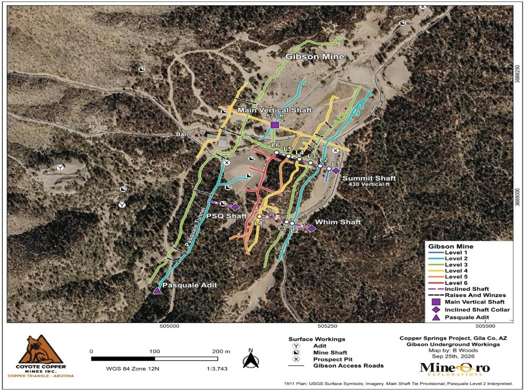
Figure 1. The Gibson Mine location map, located within the western segment of Copper Springs Project, Coyote Copper Mines Inc.
In August 2025, the Corporation collected ten samples across the Gibson Structural Corridor (GSC), comprising of six bedrock samples from areas of observed copper oxide mineralization and structural zones and four selective grab samples from historic ore piles in the West Gibson area. The grab samples from historic ore piles were collected to characterize the nature of historic mineralization and are not representative of the overall mineralization on the property.
Across all ten samples, copper values ranged from 0.091% to 22.41%. Silver values ranged from below detection to 69.3 g/t. Grab samples are selective by nature and may not be representative of the mineralization hosted on the property.
The four selective grab samples from the West Gibson zone returned copper grades ranging from approximately 10% to 22% Cu. These were select grab samples, collected from historic ore piles to characterize the mineralization. Quartz-chalcopyrite veining, massive chalcopyrite and associated hematite are observed in relation to a set of thin mineralized porphyritic dike sets which is parallel to the primary Gibson mine structure. Silver values in these samples ranged from 10.6 to 69.3 g/t.
Sample
Easting
Northing
Elevation_m
Width_m
Cu_percent
Ag_ppm
Mo_ppm
1939401
503536
3688756
1527
1.2
0.09
0.1
9
1939402
503538
3688756
1527
1.5
0.16
0.1
17
1939403
503541
3688755
1527
1.1
0.32
0.1
14
1939404
503450
3688662
1500
19.28
52.3
23
1939405
503450
3688661
1500
13.96
20.5
20
1939406
503450
3688660
1500
22.41
69.3
31
1939407
503437
3688624
1515
10.01
10.6
9
1939408
504612
3687893
1478
2.1
0.87
1
2
1939409
504612
3687896
1477
1.3
0.9
0.9
2
1939410
504601
3687930
1473
1.2
0.66
1.8
2
Min
0.09
0.1
2
Max
22.41
69.3
31
Avg
6.87
15.7
13
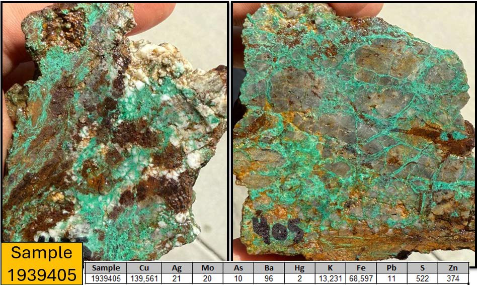
Figure 3. Selected surface grab sample 1939405 from the Gibson Mine, 1.6m, with geochemical sample results in chart.
All information in this section is derived from historical sources and prior third-party reports. It does not constitute a current NI 43-101 mineral resource or reserve estimate and has not been independently verified by the Corporation’s Qualified Person.
The Gibson copper mine is in the headwaters of Pinto Creek and is approximately 7.5 miles southwest of Miami, Arizona.
Chalcocite enrichment played an important role in developing the high-grade copper ores localized along the Summit and Pasquale veins (Peterson, 1963). Underlying primary sulfide mineralization along these structural zones is characterized by massive chalcopyrite with considerable bornite in a quartz gangue lesser amounts of calcite and minor amounts of specular hematite and gypsum (Stevens, 1911).
The Gibson Mine was a copper-silver producer operating primarily from 1906 to 1918 with intermittent production continuing through 1975. The mine was hosted on 16 patented and 53 unpatented claims and was operated by several successive owners including the Gibson Consolidated Copper Co. as the primary producer.
Mineralization comprised multiple veins hosted in the Pinal Schist with the Summit and Pasquale veins being the most prominent. Total historical production is estimated at approximately 12,500,000 pounds of copper and 3,500 oz. of silver (Sources: Arizona Bureau of Mines; U.S. Bureau of Mines, 1937–53.).
A Historical Resource for the Gibson mine is referenced in USGS MRDS Record #10104088, taken from K.R. Long, 1995 compilation of Porphyry Copper Deposits.
Coyote Copper’s initial target of 35-45 million tons grading 0.3% – 0.5% is based on the historical resource.
The potential quantity and grade is conceptual in nature, there has been insufficient exploration to define a mineral resource, and it is uncertain if further exploration will result in the target being delineated as a mineral resource
Terms of the Option Agreement
Subject to the right of the Corporation to terminate the option Agreement at any time. The Corporation is required to make the following payments (the “Payments”) to the Friars for an aggregate price of US$1.4 million after the effective date of the Option Agreement (the “Effective Date”).
The Payments are as follows:
$500,000 within 14 days of the Effective Date;
$200,000 on or before the first anniversary after the Effective Date;
$200,000 on or before the second anniversary after the Effective Date;
$200,000 on or before the third anniversary after the Effective Date;
$300,000 on or before the fourth anniversary after the Effective Date.
For a total aggregate price of US$1.4 million.
The Corporation shall have the right to exercise the Option at any time after the Effective Date by giving the Friars at least ten (10) days prior written notice of such early exercise of the Option and by paying to the Friars all Payments not yet paid.
QUALIFIED PERSON
Michael N. Feinstein, PhD, CPG, is the “Qualified Person” under National Instrument 43-101 – Standards of Disclosure for Mineral Projects, and he has reviewed and approved the scientific and technical disclosure contained in this press release. Mr. Feinstein is independent of the Corporation.
Neither the Exchange nor its Regulation Services Provider (as that term is defined in the policies of the Exchange) accepts responsibility for the adequacy or accuracy of this release.
This news release does not constitute an offer to sell or a solicitation of an offer to buy any of the securities in the United States. The securities of the Company have not been and are not expected to be registered under the United States Securities Act of 1933, as amended (the “U.S. Securities Act“), or any state securities laws, and may not be offered or sold within the United States or to U.S. persons absent registration or an applicable exemption from registration requirements.
Cautionary Statement Regarding Forward-Looking Information
This news release contains statements which constitute “forward-looking information” within the meaning of applicable securities laws, including statements regarding the plans, intentions, beliefs and current expectations of the Corporation.
Often, but not always, forward-looking information can be identified by the use of words such as “plans”, “expects”, “is expected”, “budget”, “scheduled”, “estimates”, “forecasts”, “intends”, “anticipates”, or “believes” or variations (including negative variations) of such words and phrases, or statements formed in the future tense or indicating that certain actions, events or results “may”, “could”, “would”, “might” or “will” (or other variations of the foregoing) be taken, occur, be achieved, or come to pass. Forward-looking information in this news release includes, without limitation, statements regarding, planned exploration activities including drilling, permitting for exploration, environmental remediation outcomes, and the potential for mineral resource delineation on the property. Forward-looking information is based on currently available financial and economic data and operating plans, strategies or beliefs as of the date of this news release, but involve known and unknown risks, uncertainties, assumptions and other factors that may cause the actual results, performance or achievements of the Corporation to be materially different from any future results, performance or achievements expressed or implied by the forward-looking information. Such factors may be based on information currently available to the Corporation including information obtained from third-party industry analysts and other third-party sources, and are based on management’s current expectations or beliefs. Any and all forward-looking information contained in this news release is expressly qualified by this cautionary statement.
Investors are cautioned that forward-looking information is not based on historical facts but instead reflects management’s expectations, estimates or projections concerning future results or events based on the opinions, assumptions and estimates of management considered reasonable at the date the statements are made. Forward-looking information reflects management’s current beliefs and is based on information currently available to them and on assumptions they believe to be not unreasonable in light of all of the circumstances. In some instances, material factors or assumptions are discussed in this news release in connection with statements containing forward-looking information. Such material factors and assumptions include, but are not limited to, those risk factors applicable to mineral exploration companies, including risks related to title to mineral properties, environmental liabilities, permitting delays, exploration results, and commodity prices. Although the Corporation has attempted to identify important factors that could cause actual actions, events or results to differ materially from those described in forward-looking information, there may be other factors that cause actions, events or results to differ from those anticipated, estimated or intended. Forward-looking information contained herein is made as of the date of this news release and, other than as required by law, the Corporation disclaims any obligation to update any forward-looking information, whether as a result of new information, future events or results or otherwise. There can be no assurance that forward-looking information will prove to be accurate, as actual results and future events could differ materially from those anticipated in such statements. Accordingly, readers should not place undue reliance on forward-looking information.
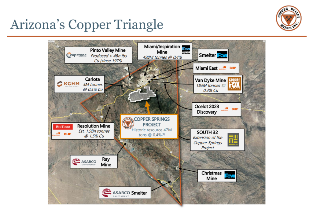
Toronto, Ontario–(Newsfile Corp. – October 28, 2026) – Coyote Copper Mines Inc. (TSXV: CCMM) (“Coyote Copper” or the “Company”) is pleased to provide an exploration update from its Copper Springs Project in Arizona’s Copper Triangle (Figure 1). Since the February and March geophysical programs, the Company has expanded its land position and carried out additional geophysical surveys, surface mapping and sampling to refine drill targets. Proceeds from the accelerated warrant exercise provided funding for the expanded exploration and staking program. Drilling is scheduled to begin around November 16, 2026.
Dan Weir, CEO of Coyote Copper Mines Inc., commented;
“Coyote Copper has signed Confidentiality Agreements (“CA’s”) with 6 major copper mining companies some of which have visited the project multiple times. Other company visits are being planned.”
“After successful geophysics programs in February and March of 2026, the company increased the original USD$200,000 geophysics budget to USD$1,500,000, increased our land position, and added expanded soil geochem and rock sampling programs. This effort was endorsed by the six major copper mining companies with which we have signed CA’s. The project continues to return great results and demonstrates the potential for multiple porphyry copper deposits. The expanded exploration program is ongoing, with efforts focused on prioritizing Phase One drill targets from our 37 permitted drill sites. With such a huge project and so many viable targets being revealed, we expect to be making a huge impact in the area, and for our investors.”
Highlights
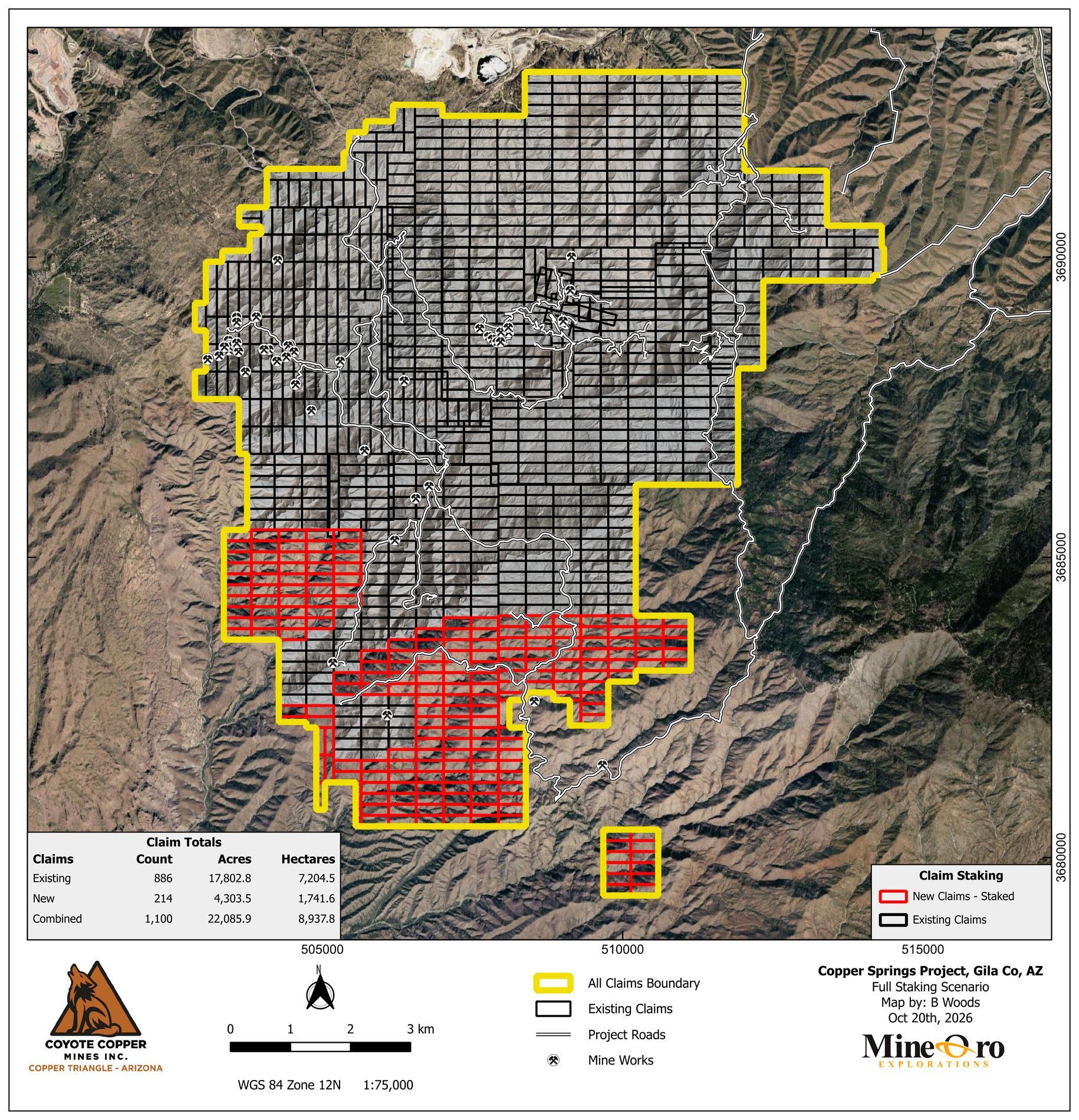
● 214 additional claims have been staked, bringing Copper Springs to 1,100 claims covering approximately 22,086 acres (89.4 km²) (Figure 2).
● Rock chip results (Figure 3, Table 2):
○ West Gibson: 19.25% Cu over 0.60 m.
○ Around Gibson: 13.79% Cu over 0.30 m.
○ Maher: 0.54% Cu and 4,841.8 ppm molybdenum (Mo) over 0.50 m.
Assays are pending for 1,056 soil samples, 117 rock samples and 46 channel samples (Table 1). Regional soil sampling is complete across the expanded land position. A further 679 soil samples are planned for infill over the Santa Ana chargeability anomaly and surrounding targets.
● Drone surveying began on October 19 to extend magnetic coverage beyond the February survey area and collect radiometric data across the Project.
● Strong chargeability response near Santa Ana is evident in preliminary induced polarization (IP) results. TMC Geophysics and Zonge Geophysics continue IP and electromagnetic surveys across the Project (Figure 6, Table 3).
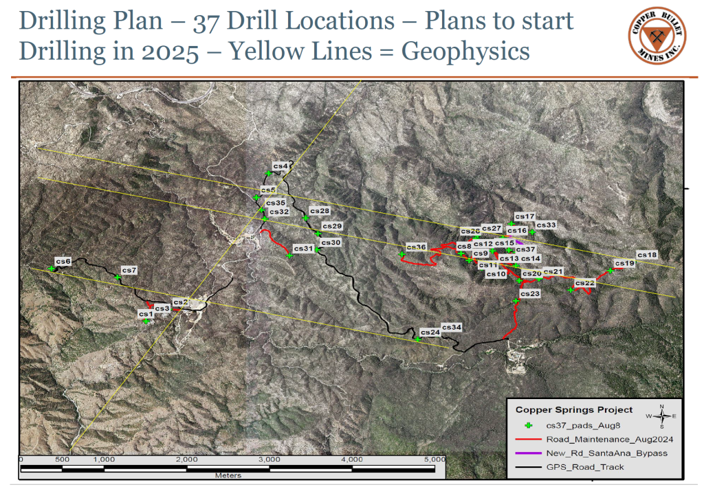
● Major Drilling is scheduled to begin drilling around November 16, 2026. Permits cover road construction and 37 drill locations (Figure 9). Phase 1 will test shallow oxide and deeper sulfide targets.
Regional Setting and Exploration Focus
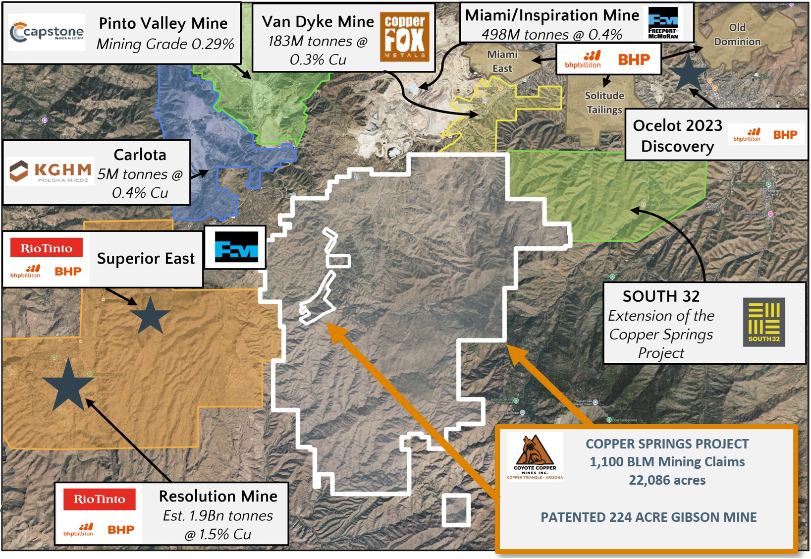
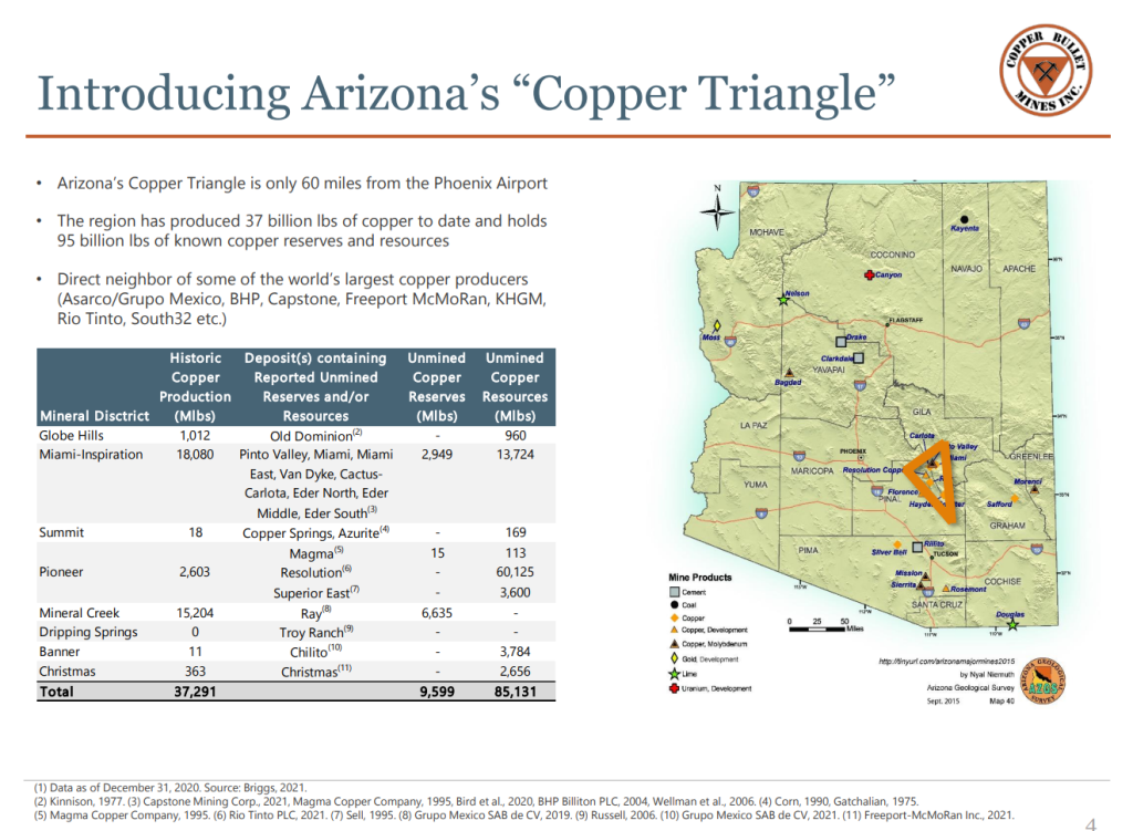
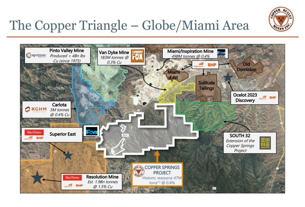
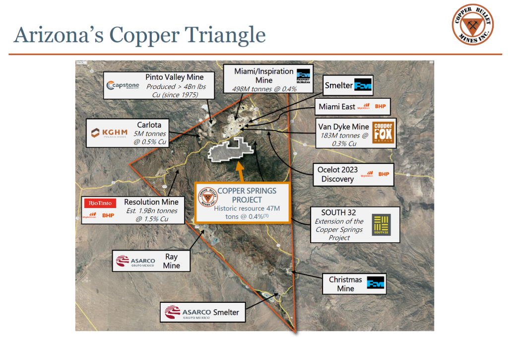
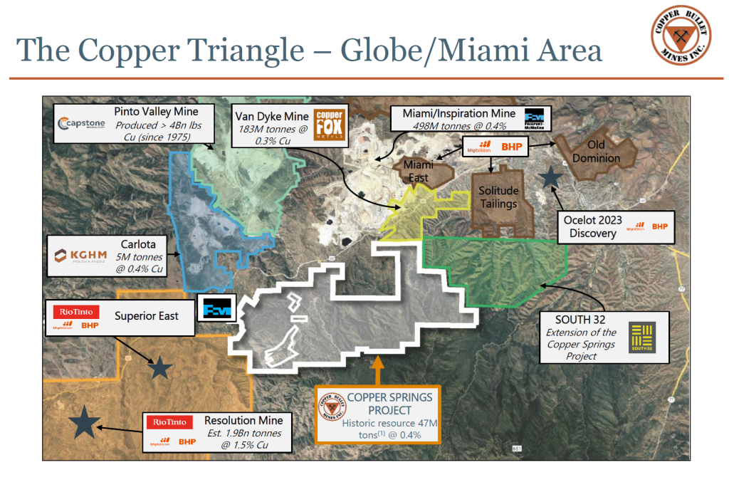
Copper Springs lies near Globe and Miami in Arizona’s Copper Triangle, within the porphyry copper belt that hosts Pinto Valley, Miami and Resolution (Figure 1).
Figure 1. Location of Copper Springs among copper deposits and operations in Arizona’s Copper Triangle.
The Company recently staked 214 additional claims based on geophysical and soil sampling results. The expanded land position now includes 1,100 claims, up from 886, and covers approximately 22,086 acres (89.4 km²). Additional mapping and soil sampling are planned or in progress across the expanded project area.
Figure 2. Existing and newly staked claims at Copper Springs.
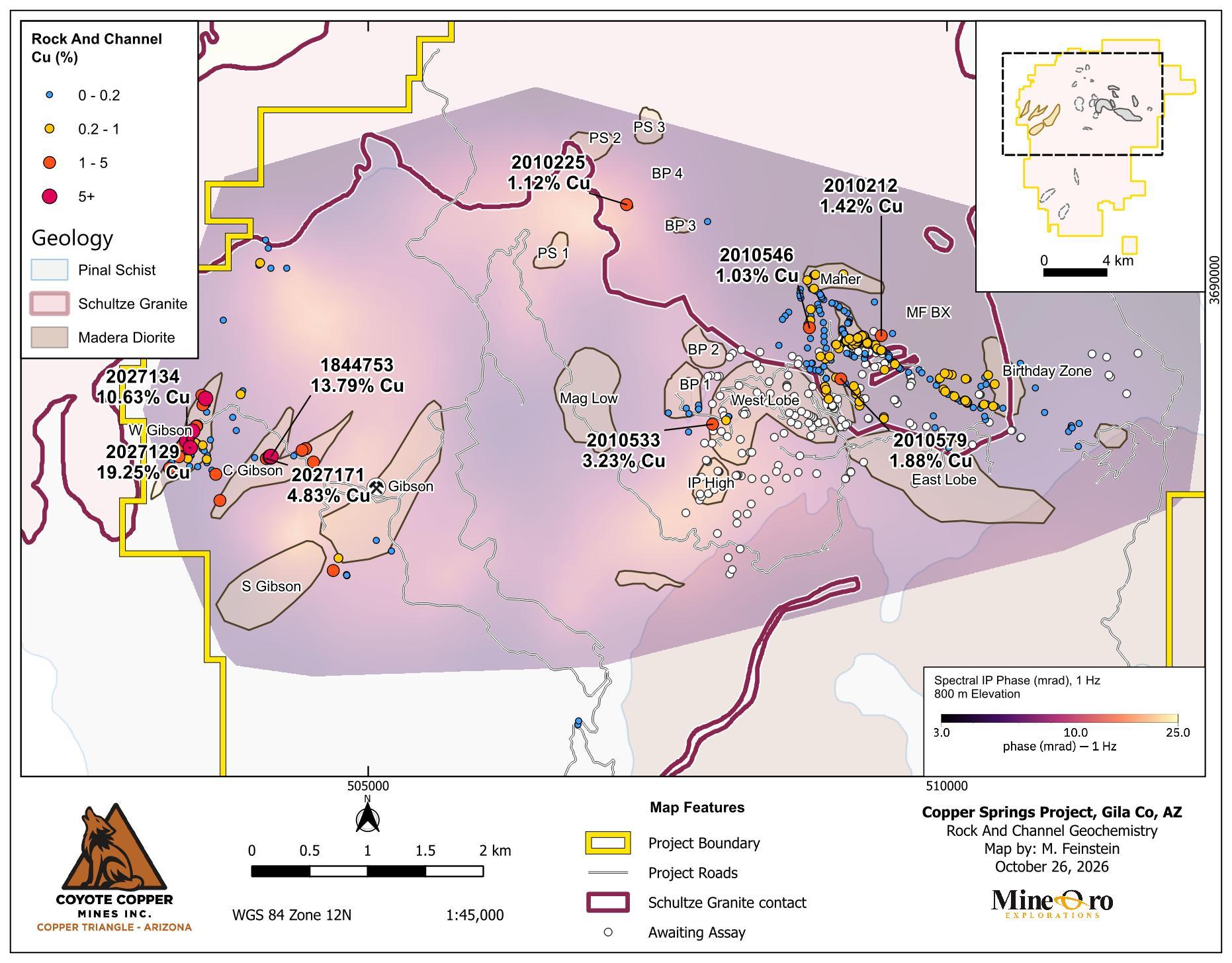
Copper assay results are available for 2,729 of the 3,948 rock, channel and soil samples collected during the program (Table 1). Rock and channel sampling characterize exposed mineralization (Figure 3), while soil surveys outline geochemical patterns across a wider area for comparison with mapped geology and geophysical responses.
Table 1. Surface Sampling
Sample type
Collected
Cu assays
Rock
454
337
Channel
399
353
Soil
3,095
2,039
Channel sampling totals 396.39 m across 399 samples. Assays are pending for 1,056 of the collected soil samples.
Grab, dump and selective chip samples may not represent the average grade of the mineralization.
Figure 3. Rock and channel copper assays (%) over spectral IP phase at 800 m elevation.
Rock and channel sampling tests copper-bearing quartz veins, faults and exposed mineralization at West Gibson, area around the Gibson Mine, Santa Ana and MF. Table 2 presents samples returning at least 1% Cu, together with selected molybdenum and channel results.
These results exclude samples reported in the Company’s October 1, 2025 and April 30, 2026 news releases and historical 2016 Teck samples.
Table 2. Significant Surface Sampling Results
Sample
Target
Type
Width (m)
Easting
Northing
Cu (%)
Mo (ppm)
Ag (g/t)
Certificate
2027129
West Gibson
Rock chip
0.60
503463
3688553
19.25
18.50
17.85
SP0158872
2027134
West Gibson
Rock chip
0.80
503433
3688611
10.63
37.40
15.30
CYTE26-001
1844755
West Gibson
Rock chip
0.60
503483
3688696
8.06
21.00
10.07
SP0156942
2027150
West Gibson
Selective grab (dump)
503595
3688978
6.19
36.50
2.90
CYTE26-001
2027151
West Gibson
Rock chip
503563
3689006
4.46
6.70
0.90
CYTE26-001
2027127
West Gibson
Rock chip
0.50
503401
3688576
4.38
14.40
5.34
SP0158872
2027126
West Gibson
Dump grab
503365
3688475
4.32
4.90
4.22
SP0158872
2027124
West Gibson
Rock chip
1.00
503285
3688376
3.84
9.40
1.62
SP0158872
2027145
West Gibson
Selective grab (dump)
503368
3688516
3.79
1.70
4.40
CYTE26-001
2027152
West Gibson
Rock chip
503572
3688923
3.08
6.90
3.30
CYTE26-001
1844757
West Gibson
Rock chip
0.70
503515
3688737
2.84
8.00
1.85
SP0156942
1844756
West Gibson
Rock chip
0.45
503483
3688693
1.90
4.30
9.84
SP0156942
2027142
West Gibson
Rock chip
503437
3688544
1.63
0.90
0.70
CYTE26-001
2010815
West Gibson
Rock chip
1.00
503365
3688504
1.44
2.50
2.50
CYTE26-006
1844758
West Gibson
Rock chip
0.25
503519
3688741
1.19
8.10
1.25
SP0156942
2027133
West Gibson
Rock chip
1.00
503422
3688599
1.18
0.70
7.90
CYTE26-001
2027125
West Gibson
Rock chip
1.50
503282
3688374
1.09
2.00
1.00
SP0158872
1844753
Around Gibson
Rock chip
0.30
504161
3688477
13.79
17.60
28.85
SP0156942
1844752
Around Gibson
Rock chip
0.20
504153
3688474
6.30
10.20
8.87
SP0156942
1844750
Around Gibson
Rock chip
0.60
504155
3688472
5.93
5.80
1.80
SP0156942
2027171
Around Gibson
Rock chip
1.00
504120
3688459
4.83
0.90
0.40
CYTE26-001
2027165
Around Gibson
Selective chip
0.20
503719
3688097
4.07
7.60
10.70
CYTE26-001
1844748
Around Gibson
Selective grab
504698
3687492
3.75
168.40
2.38
SP0156942
1844749
Around Gibson
Rock chip
0.60
504155
3688473
3.66
8.60
5.46
SP0156942
2027164
Around Gibson
Rock chip
1.00
503683
3688323
3.07
9.20
2.10
CYTE26-001
2027172
Around Gibson
Selective chip
1.00
504527
3688429
3.05
4.20
1.10
CYTE26-001
2027153
Around Gibson
Rock chip
1.00
504429
3688531
2.34
2.10
6.00
CYTE26-001
2027154
Around Gibson
Rock chip
0.50
504459
3688544
2.28
0.50
2.00
CYTE26-001
2027155
Around Gibson
Rock chip
0.80
504459
3688544
1.90
0.80
1.20
CYTE26-001
2027156
Around Gibson
Selective chip
0.50
504459
3688544
1.09
0.20
0.30
CYTE26-001
1844751
Around Gibson
Rock chip
1.20
504154
3688473
1.06
2.40
0.60
SP0156942
2010533
West Lobe
Dump grab
507975
3688755
3.23
211.00
0.60
CYTE26-005
2010579
Santa Ana
Rock chip
1.00
509083
3689147
1.88
28.90
1.80
CYTE26-006
2010212
Rock chip
0.50
509433
3689521
1.42
8.40
3.66
SP0158872
2010225
BP 4
Rock chip
0.50
507232
3690652
1.12
9.40
6.50
SP0158872
2010546
Rock chip
508812
3689589
1.03
734.00
11.60
CYTE26-006
2010922
MF BX
Channel
1.00
509229
3689501
0.91
3.30
1.60
CYTE26-005
2010202
Maher
Rock chip
0.50
509105
3690051
0.54
4,841.80
1.44
SP0158872
2010544
Rock chip
508820
3689652
0.43
1,500.00
1.00
CYTE26-006
2010543
Rock chip
508825
3689691
0.19
2,000.00
0.60
CYTE26-006
2010594
Rock chip
508816
3689230
0.17
3,030.00
1.60
CYTE26-006
2010565
Santa Ana
Rock chip
1.50
508950
3689044
0.14
1,850.00
6.00
CYTE26-006
2010536
Rock chip
508731
3689866
0.013
1,480.00
0.10
CYTE26-006
2010556
Black Rock
Rock chip
1.50
505877
3682220
2.78
4.10
19.60
CYTE26-006
2026316
Poly BX
Tailings grab
506670
3684380
1.60
92.00
64.20
SP0155090
2010224
Red Rock QSP
Rock chip
0.50
505008
3683253
1.41
37.80
79.51
SP0158872
2026308
Red Rock QSP
Rock chip
504980
3683226
1.27
4.00
3.20
SP0155090
2026306
Red Rock QSP
Dump grab
504951
3683198
1.18
1.00
0.40
SP0155090
Coordinates are WGS84 UTM Zone 12N. Blank widths indicate that no sample width is reported. Widths are sampled lengths and are not true widths.
Soil Geochemistry
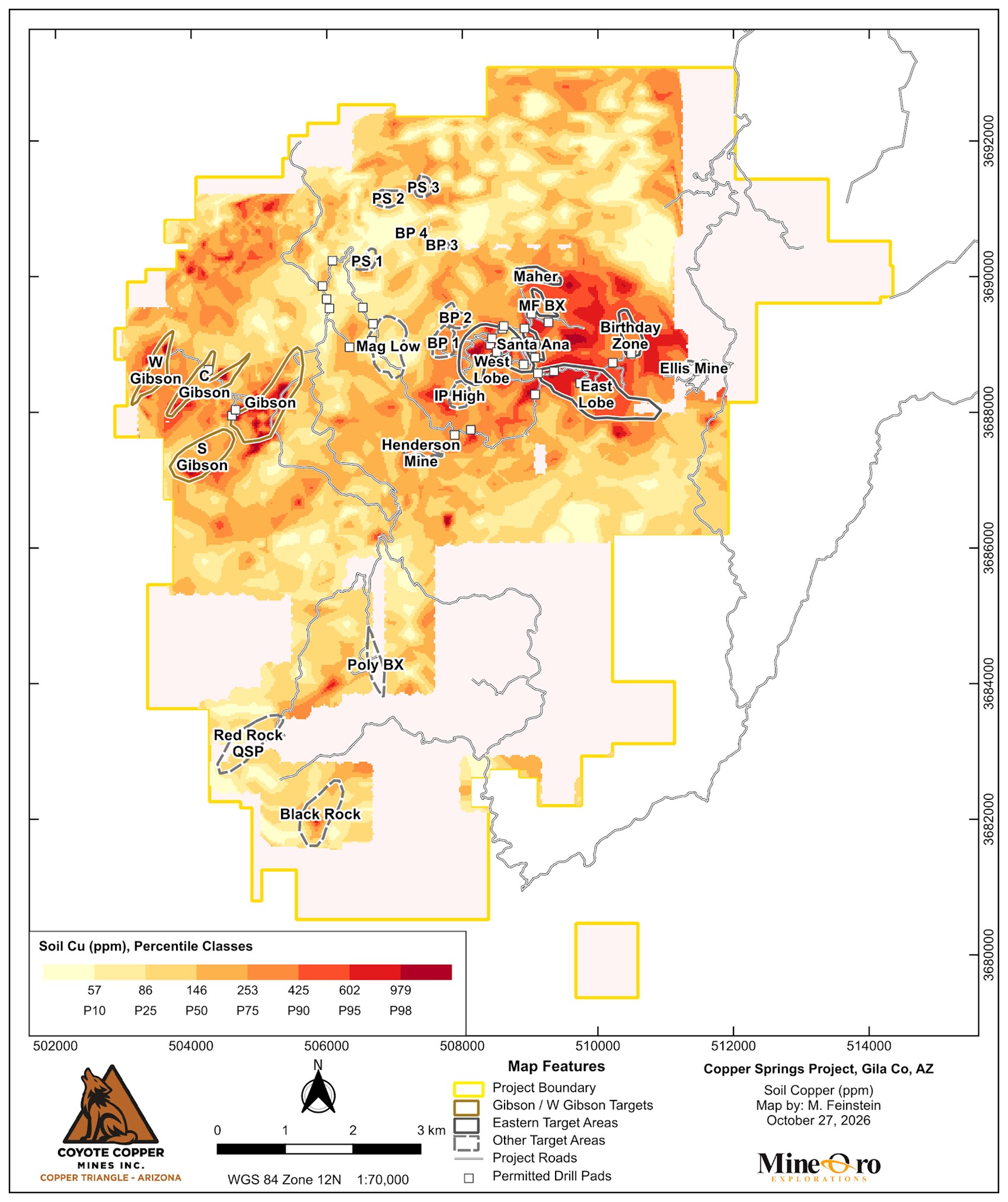
Soil copper anomalies help guide follow-up exploration in the area close to Gibson, West Gibson and Santa Ana exploration areas highlighted in Figure 4. Regional soil sampling has been completed across the remaining areas within the new project boundary at 100 m and 200 m spacing, with 1,056 samples awaiting assays.
Figure 4 shows the previously reported soil copper anomalies in relation to the mapped exploration targets. A further 679 soil samples are planned over the Santa Ana chargeability anomaly and surrounding targets.
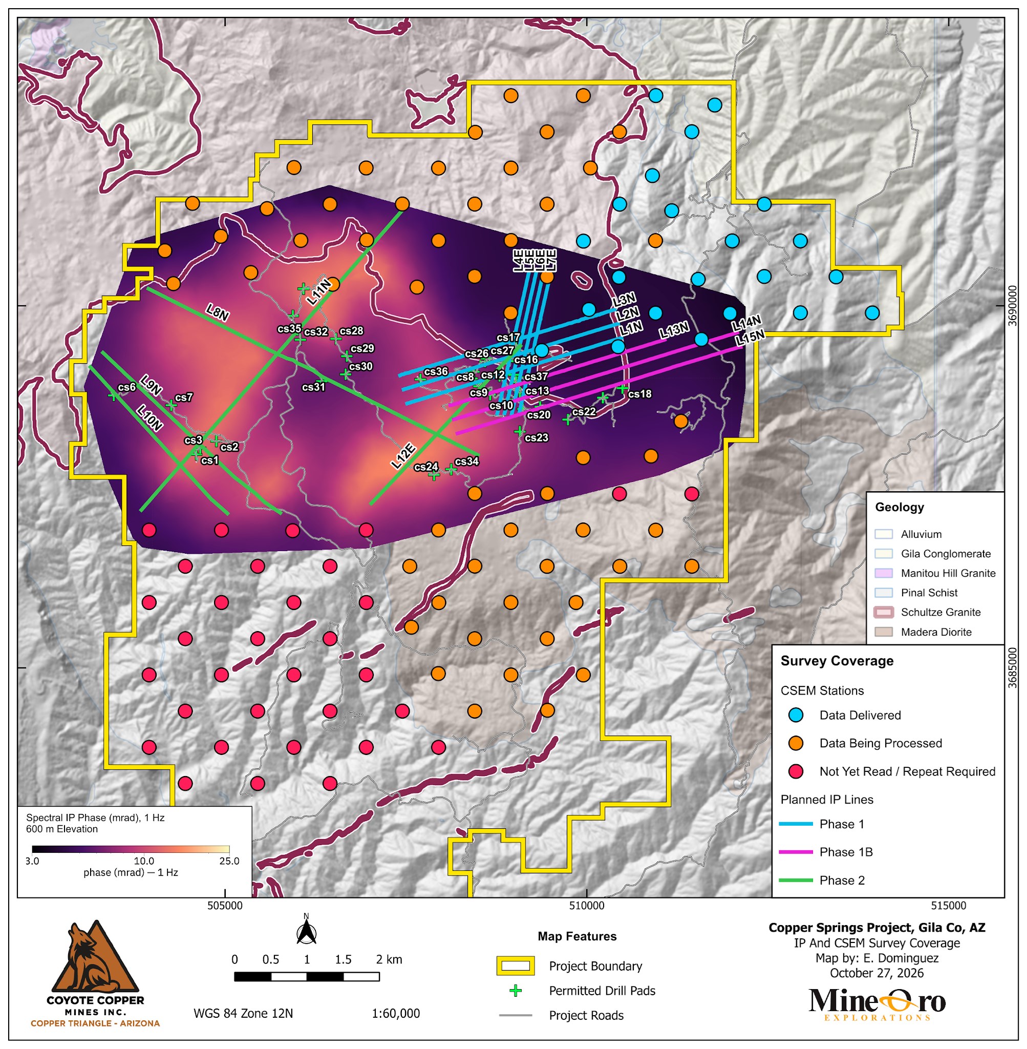
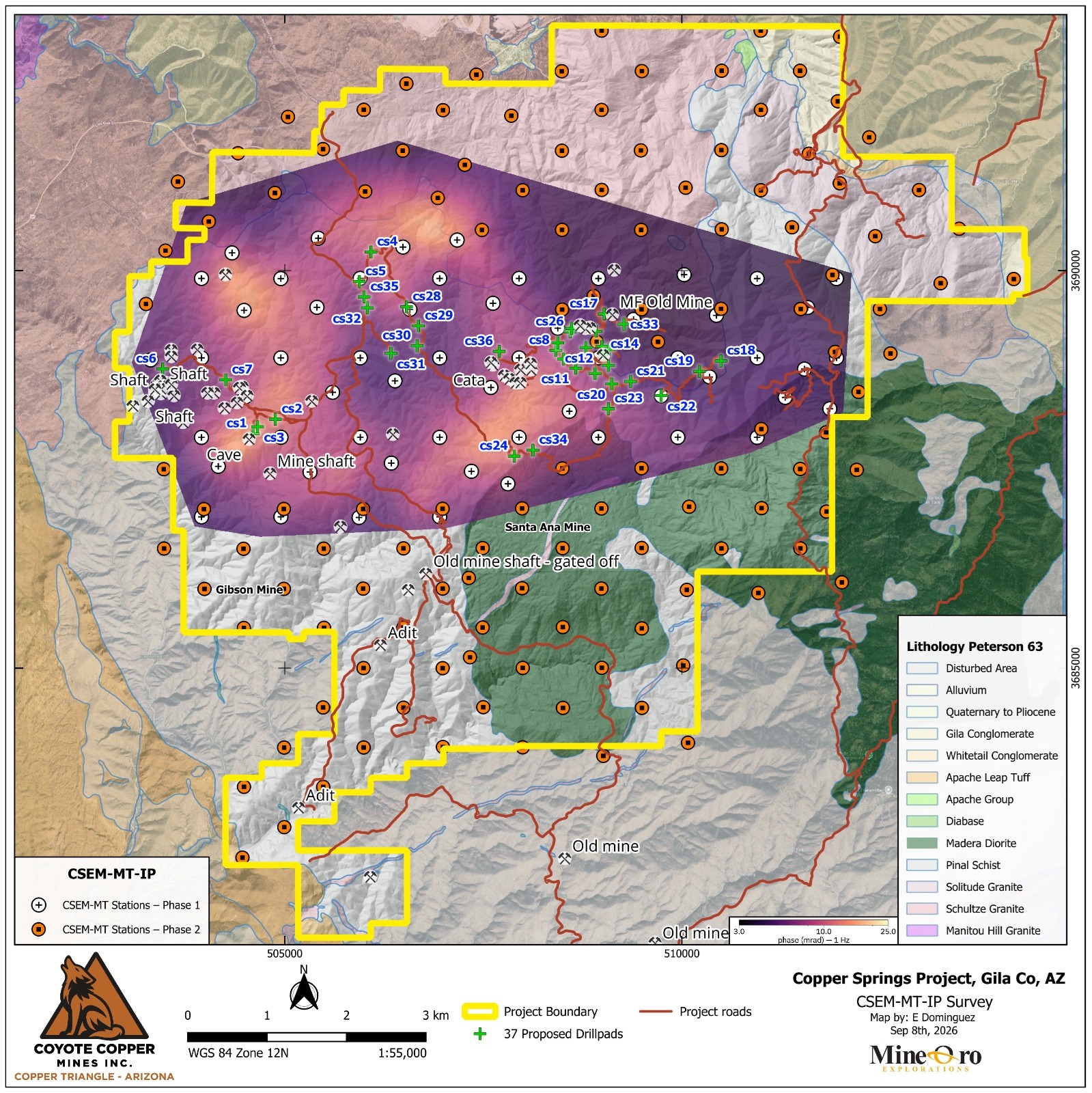
Geophysical surveying continues across the Project, including 2D IP work tying Gibson to the Santa Ana area across the IP “Donut” (Figure 5). Preliminary 2D IP results show a strong chargeability response near Santa Ana (Figures 6 to 8).
Figure 5. Planned IP lines and CSEM stations over spectral IP phase at 600 m elevation.
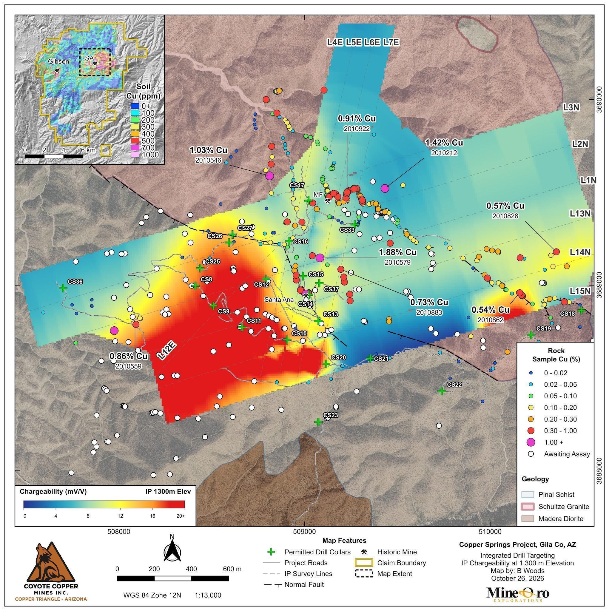
Field mapping has focused on ground-truthing the geophysical signatures. The strongest chargeability response lies west of the main surface copper occurrences (Figure 6), and this south-western high reaches surface at two locations that coincide with copper oxides. The sulfide mineralization exposed at MF Creek and Santa Ana correlates with an intermediate chargeability response. Assays are pending for many of the samples collected over the chargeability high. Mapping and assay results will guide drillhole placement to test whether the exposed mineralization connects with the chargeability response at depth.
Figure 6. Surface copper assays in percent over modeled chargeability at 1,300 m above sea level.
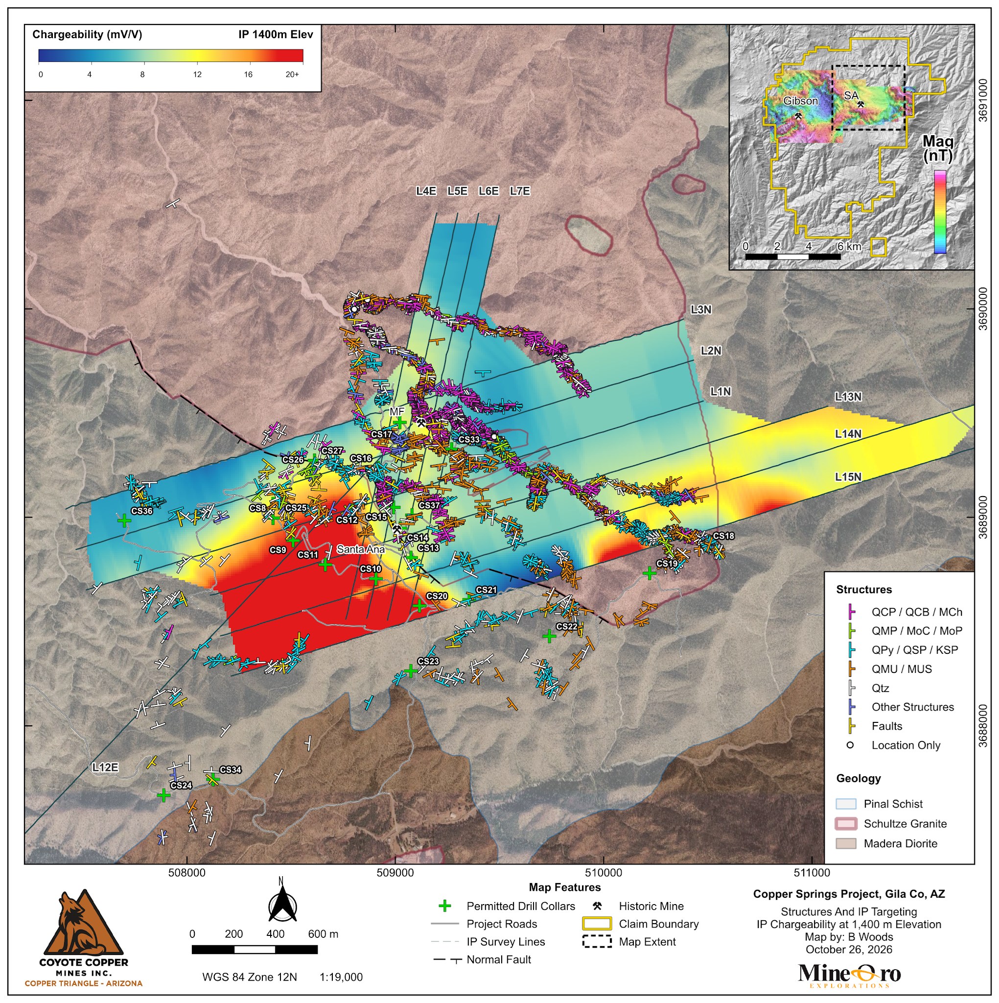
Structural mapping has recorded 3,614 measurements to date: 3,428 veins, 145 faults and 41 other structures. The mapped veins and faults extend across the chargeability response (Figure 7), and they are being used to define the structural controls on mineralization and to target drilling for both shallow and deep targets.
Figure 7. Vein and fault measurements over modeled chargeability at 1,400 m elevation.
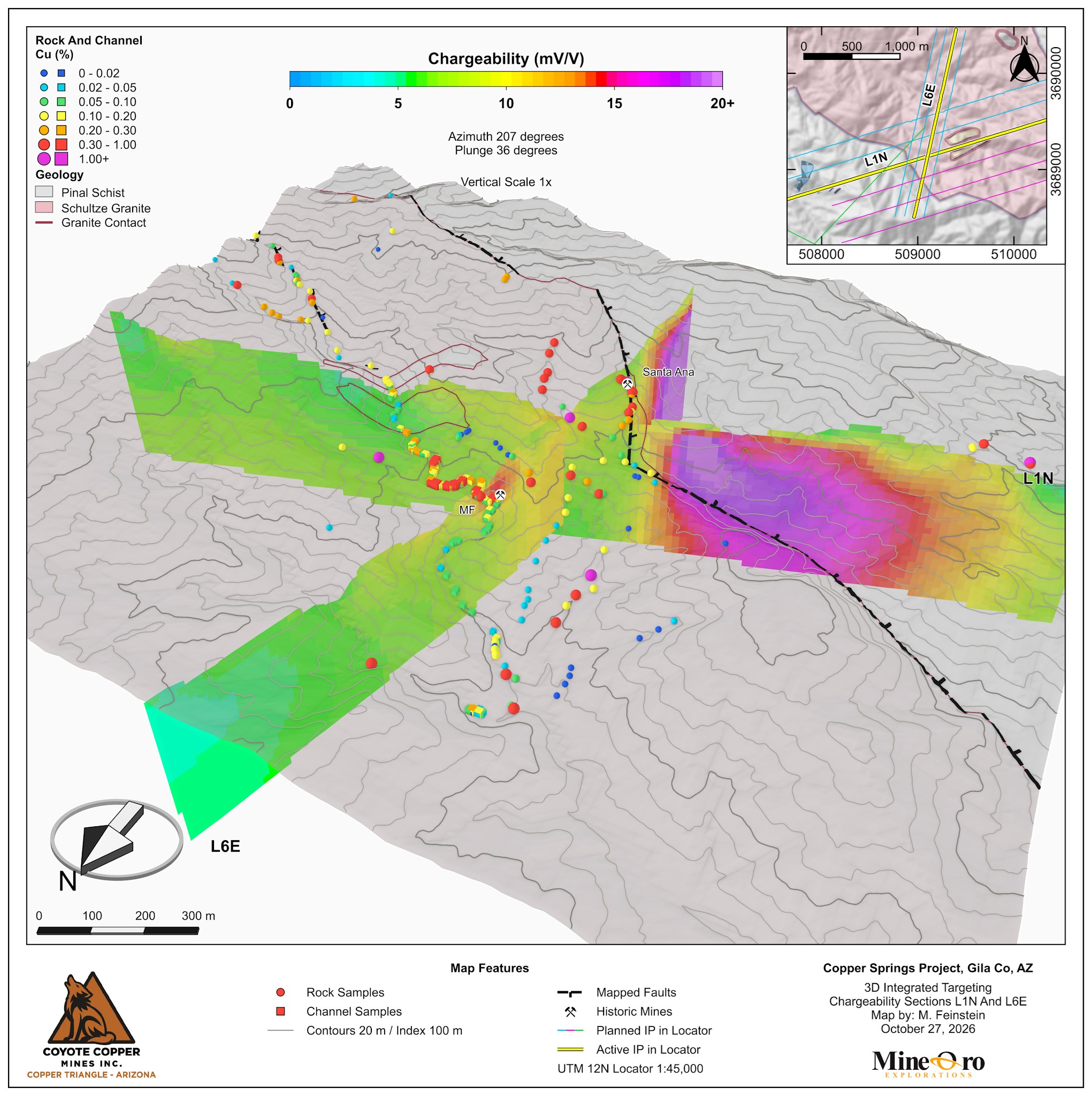
Intersecting chargeability sections L1N and L6E show the modeled response beneath the surface geology (Figure 8). The response is strongest on L1N beneath the Santa Ana area and weaker on the intersecting L6E section. The three-dimensional view also shows that much of the copper-sulfide mineralization is associated with intermediate chargeability outside the large south-western high, and this subsurface information is being used to plan drillhole intercepts with geophysical features.
Figure 8. Three-dimensional view of modeled chargeability sections L1N and L6E with surface geology and copper assays.
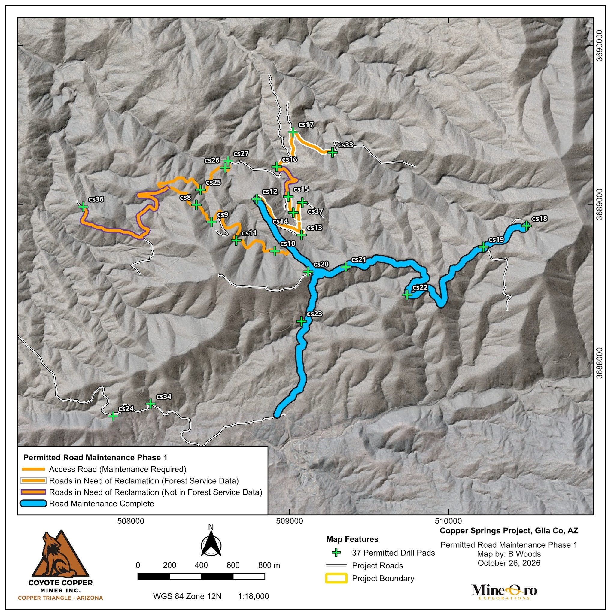
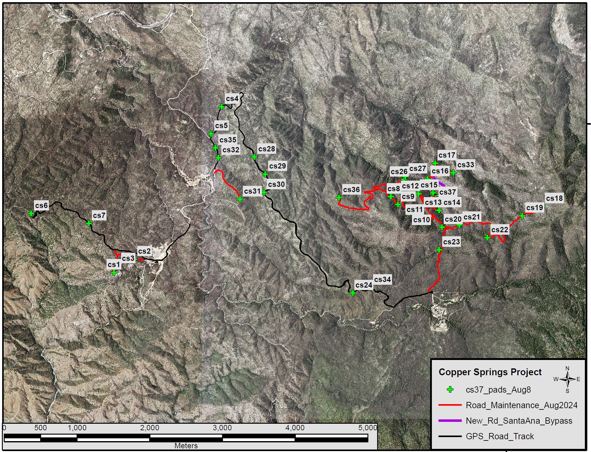
Permit approvals have been received for 37 Phase 1 drill locations, each capable of accommodating multiple drillholes. Road construction is advancing on schedule to support the November start of drilling. Figure 9 shows the planned access network and construction progress toward the initial drill sites. Major Drilling is scheduled to begin drilling around November 16, 2026.
Figure 9. Phase 1 access routes and permitted drill sites at Copper Springs.
The November 23, 2025 technical report contains no current mineral resource or mineral reserve estimate.
Sampling, Analysis And Quality Control
MineOro collected channel, rock chip and selective grab samples. Channels were cut with a diamond saw to approximately 3 inches depth, and continuous rock chips were collected across marked intervals. Selective grabs were collected from outcrop and mine dumps. Sample types, locations, widths and analytical results are provided in Table 2.
Samples were uniquely numbered, bagged and sealed, with photographed sites and handheld GPS locations recorded in WGS84 UTM Zone 12N. Samples were securely stored before delivery or courier shipment to the analytical laboratories.
Soils were collected from B-C horizons at depths of 6 to 12 inches and sieved to 60 mesh in the field.
Verification included comparing assay data with field records and laboratory reports and reviewing standards, blanks and laboratory repeats. Rock laboratory repeats assess analytical precision. No field or coarse-reject duplicates were available in the reviewed rock dataset to assess sampling and preparation variability. For mapping, results below detection were assigned numerical values, primarily half the detection limit. Results above range without a final overlimit assay were capped at the reporting limit.
Skyline Assayers & Laboratories, Tucson, Arizona, prepared and analyzed rock, channel and soil samples. Skyline holds ISO/IEC 17025 accreditation for the relevant preparation and analytical methods.
Skyline determined total copper by multi-acid digestion with an AAS finish (CuT) and multielement concentrations by near-total multi-acid digestion with ICP-OES/ICP-MS (TE-5). Overrange copper was determined by long iodide titration and overrange molybdenum by single-element assay.
American Assay Laboratories (AAL), Sparks, Nevada, holds ISO/IEC 17025 accreditation. Rock preparation comprised crushing to 70% passing 2 mm, splitting 300 g and pulverizing to 85% passing 75 µm. Analysis used a 0.5 g four-acid plus boric acid digestion with ICP-OES or ICP-OES/ICP-MS (IO-4AB51 or IM-4AB52). Copper above 10,000 ppm was determined by ore-grade ICP-OES (IO-4ABOR).
ALS prepared 437 soil samples in Tucson, Arizona, by screening to minus 180 µm and analyzed them in North Vancouver, British Columbia, using a 0.5 g aqua regia digestion with ICP-MS/ICP-AES (ME-MS41L).
Skyline, AAL and ALS are independent commercial laboratories. MineOro conducts the sampling program for the Company.
MineOro’s field quality-control program includes certified reference materials and blanks at approximately 5% of the rock and channel sample stream, and certified reference materials and field duplicates at approximately 2% of the soil sample stream. Skyline and AAL also analyzed laboratory reference materials, blanks and duplicates with each batch. Some certified reference materials in the AAL soil batches returned low copper recoveries. The soil results were accepted for reconnaissance interpretation.
Qualified Persons
Michael N. Feinstein, PhD, CPG, of MineOro, is the Company’s project Qualified Person and is independent of the Company under NI 43-101. He prepared, reviewed and approved the scientific and technical disclosure in this release and has verified the supporting data. Bay Woods, CPG, prepared or supervised implementation of the maps and figures and monitored QA/QC. Both are Qualified Persons under National Instrument 43-101, Standards of Disclosure for Mineral Projects.
Neither the Exchange nor its Regulation Services Provider (as that term is defined in the policies of the Exchange) accepts responsibility for the adequacy or accuracy of this release.
Cautionary Statement Regarding Forward-Looking Information
This news release contains statements that constitute “forward-looking information” within the meaning of applicable securities laws, including statements regarding ongoing and proposed exploration activities, completion and interpretation of geophysical surveys, construction of access roads and drill pads, commencement and timing of drilling, and the objectives and potential results of exploration programs.
Forward-looking information is often, but not always, identified by words such as “plans,” “expects,” “is expected,” “scheduled,” “estimates,” “forecasts,” “intends,” “anticipates,” “believes,” “may,” “could,” “would,” “might” or “will.” Forward-looking information is based on management’s current expectations, estimates, assumptions and beliefs and is subject to known and unknown risks, uncertainties and other factors that may cause actual results, performance or achievements to differ materially from those expressed or implied. Such risks include risks applicable to mineral exploration companies, including title, permitting, environmental, exploration, contractor availability, financing and commodity-price risks.
There can be no assurance that forward-looking information will prove to be accurate. Readers should not place undue reliance on forward-looking information. Forward-looking information contained herein is made as of the date of this news release and, except as required by applicable law, the Company disclaims any obligation to update or revise such information as a result of new information, future events or otherwise.
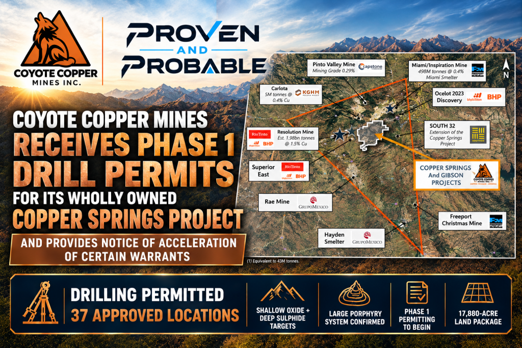
Toronto, Ontario–(Newsfile Corp. – September 15, 2026) – Coyote Copper Mines Inc. (TSXV: CCMM) (“Coyote Copper” or the “Company “) is pleased to announce that it has received full approval for its Phase 1 drill permits at the Company’s wholly owned Copper Springs Project (the “Project“), following completion of its Plan of Operations. A total of 37 drill locations has been authorized, each capable of hosting multiple drill holes. The Company has three (3) years to complete drilling and reclamation activities.
Dan Weir, CEO of Coyote Copper Mines Inc., stated: “Receiving our Phase 1 drill permits allows us to begin testing what we believe is a very large porphyry copper system. The scale of the geophysical anomalies, the strength of copper geochemistry, and the structural and intrusive architecture we have mapped all point to a significant mineralized environment. Several major mining companies have already visited the Project – some multiple times – and their technical feedback has reinforced the potential we see at Copper Springs. With 37 approved drill sites, expanding geophysical coverage, and a growing land package, we are entering Phase 1 drilling with a disciplined, systematic approach. We look forward to advancing this exceptional project.”
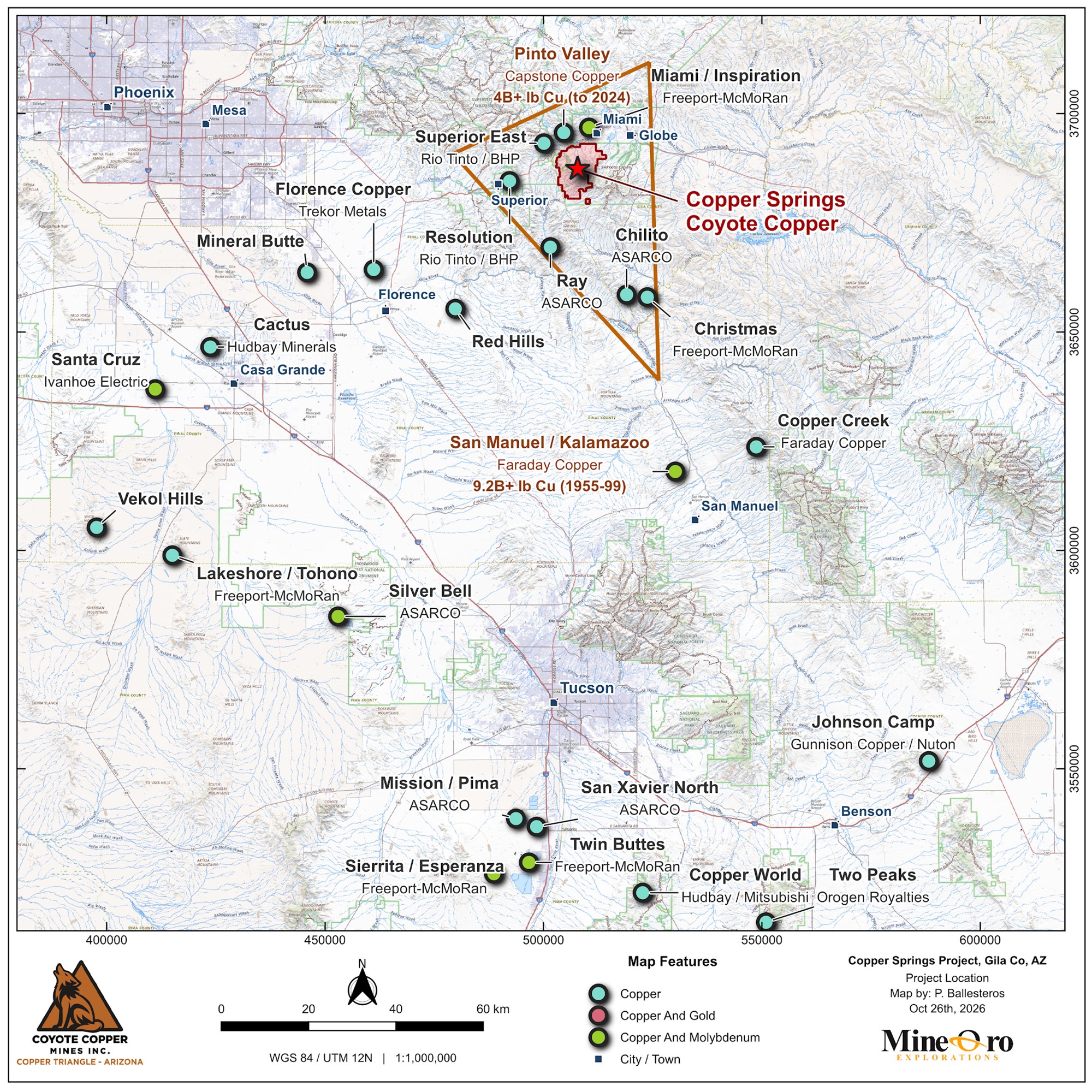
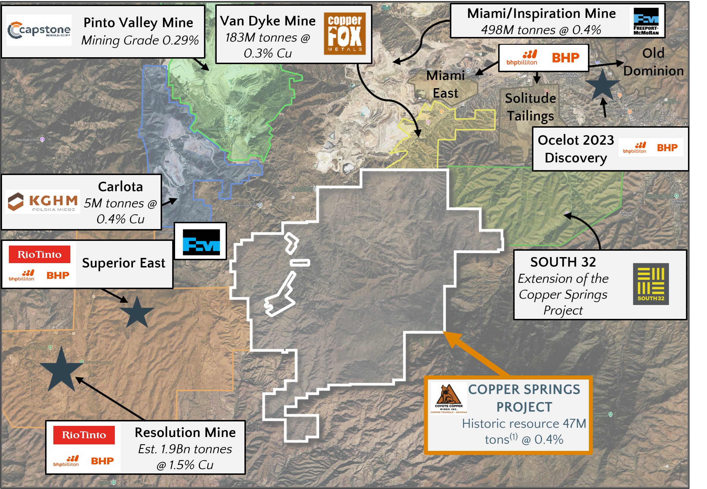
Figure 1. The Arizona Copper Triangle and Coyote Copper Mines Copper Springs Project
This Phase 1 drilling campaign (the “Campaign“) will test both shallow oxide and deeper sulphide Copper targets across the Copper Springs Project. The targets were defined through successful prior exploration programs, including mapping, sampling, and multiple generations of geophysical surveys. Additional soil sampling, channel sampling, and new geophysical work are underway to refine drill targeting. Permitting for Phase 2 drilling will begin shortly.
Operating copper mines across the western United States typically report grades between 0.2% and 0.5% Cu. Capstone Copper’s Pinto Valley Mine, located just north of Coyote Copper’s project, has a Proven and Probable grade of 0.32% Cu. Achieving similar grades during drilling would be highly encouraging.
The Company is also expanding its land position with the staking of 111 new claims (20.66 acres each), increasing the Project’s footprint from 63.33 km² (15,649 acres) to 72.36 km² (17,880 acres).
Updated Geophysical Programs
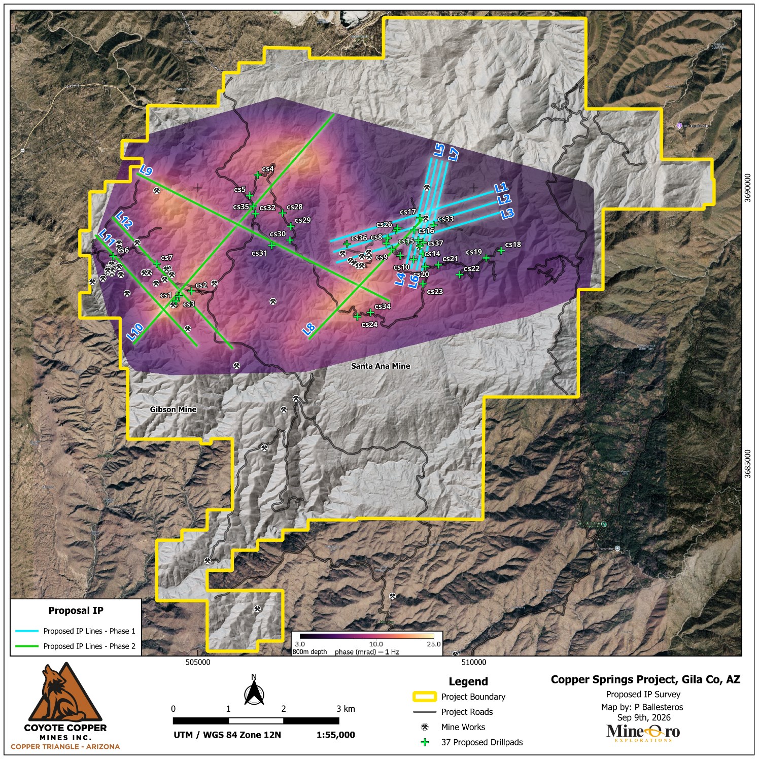
Phase 1 of the 2D Induced Polarization (IP) survey is underway, covering 17 line-kilometres across lines L1 through L7 in the central-eastern portion of the Project. Completion is expected by mid-September.
Phase 2 of the IP program (lines L8 through L12) will focus on the Gibson area and the surrounding “Donut” feature identified in earlier surveys.
Figure 3. The “Donut” geophysical feature and outlined Phase 1 and 2 IP program lines.
The Copper Springs Porphyry Copper System – the Conceptual Exploration Target
Based on the current geophysical and geochemical dataset, the Project area hosts a 3 km × 3 km × 1.4 km subsurface anomaly interpreted to represent a large intrusive-hydrothermal center consistent with a Porphyry Copper System. Surface and near-surface soil and bedrock sampling has returned copper values up to 1,000 ppm (0.1%), indicating strong hydrothermal signature and confirming the presence of a significant mineralized footprint.
The scale of the geophysical anomaly and the strength of copper geochemical anomalies are consistent with Tier-1 porphyry copper systems such as those found in the Arizona Copper Triangle, where large open-pit deposits typically grade 0.2 to 0.5% Cu with localized higher-grade zones.
The Project therefore represents a high-priority, Tier-1-scale exploration target, warranting systematic drilling to evaluate the presence, continuity, and grade of copper mineralization.
Notice of Warrant Acceleration
Certain warrants to purchase common shares of the Company (the “Warrants“) contain the following provision:
“Upon the Company receiving its drill permits, then the Company may deliver a notice (the “Acceleration Notice“) to the Warrant holder notifying such Warrant holder that the Warrants must be exercised within thirty (30) calendar days from the date of the Acceleration Notice, otherwise the Warrants will expire at 4:00 p.m. (Toronto time) on the thirtieth (30th) calendar day after the date of Acceleration Notice.”
At a recent meeting of the Board of Directors of the Company, it was approved to accelerate the Warrants upon receipt of the Phase 1 drill permits.
The following Warrants are affected by the acceleration clause:
7,519,044 Warrants with an exercise price of $0.15 from a financing that was completed in July and August of 2025.
1,644,174 have been exercised
The balance outstanding is 5,874,870
If all Warrants are exercised $881,230.50 would be received by the Company .
10,859,990 Warrants with an exercise price of $0.20 from a financing that was completed in January and February of 2026
285,716 have been exercised
The balance outstanding is 10,574,274
If all Warrants are exercised $2,114,854.80 would be received by the Company.
1,052,152 finder’s Warrants with an exercise price of $0.14 from a financing that was completed in January and February of 2026
None have been exercised
If all Warrants are exercised $147,301.28 would be received by the Company
The total amount to be received by the Company if all Warrants are exercised would be $3,143,386.58.
The acceleration date is the date of this press release being September 15, 2026. Notice of the acceleration of the Warrants is also being sent separately to all holders of Warrants.
Warrant holders will have until October 15, 2026 at 4:00 p.m. (Toronto Time) to exercise their Warrants, or these Warrants will expire.
To exercise Warrants a holder of Warrants should:
Fill out the back of the Warrant certificate and email it to DanWeir@CoyoteCopper.com by October 15, 2026 at 4:00 p.m. (Toronto Time); and
Send a money wire transfer for the exercise price of the Warrants which must be received by the Company by October 15, 2026 at 4:00 p.m. (Toronto Time).
Note: The Company has also issued 17,176,742 warrants in connection with a financing which were issued on May 28, 2026 and June 15, 2026. The exercise price of these warrants is $0.50. These warrants do not have an acceleration clause.
Qualified Person
Michael N. Feinstein, PhD, CPG, is a “Qualified Person” under National Instrument 43-101 – Standards of Disclosure for Mineral Projects, and he has reviewed and approved the scientific and technical disclosure contained in this press release. Mr. Feinstein is independent of the Company.
For more information, please contact: Dan Weir CEO, Coyote Copper Mines Inc. DanWeir@CoyoteCopper.com Tel: +1-416-720-0754
Neither the Exchange nor its Regulation Services Provider (as that term is defined in the policies of the Exchange) accepts responsibility for the adequacy or accuracy of this release.
This news release does not constitute an offer to sell or a solicitation of an offer to buy any of the securities in the United States. The securities of the Company have not been and are not expected to be registered under the United States Securities Act of 1933, as amended (the “U.S. Securities Act“), or any state securities laws, and may not be offered or sold within the United States or to U.S. persons absent registration or an applicable exemption from registration requirements.
Cautionary Statement Regarding Forward Looking Information
This news release contains statements which constitute “forward-looking information” within the meaning of applicable securities laws, including statements regarding the plans, intentions, beliefs and current expectations of the Company.
Often, but not always, forward-looking information can be identified by the use of words such as “plans”, “expects”, “is expected”, “budget”, “scheduled”, “estimates”, “forecasts”, “intends”, “anticipates”, or “believes” or variations (including negative variations) of such words and phrases, or statements formed in the future tense or indicating that certain actions, events or results “may”, “could”, “would”, “might” or “will” (or other variations of the foregoing) be taken, occur, be achieved, or come to pass. Forward-looking information in this news release includes, without limitation, statements regarding, planned exploration activities including drilling, permitting for exploration, environmental remediation outcomes, and the potential for mineral resource delineation on the property. Forward-looking information is based on currently available financial and economic data and operating plans, strategies or beliefs as of the date of this news release, but involve known and unknown risks, uncertainties, assumptions and other factors that may cause the actual results, performance or achievements of the Company to be materially different from any future results, performance or achievements expressed or implied by the forward-looking information. Such factors may be based on information currently available to the Company including information obtained from third-party industry analysts and other third-party sources, and are based on management’s current expectations or beliefs. Any and all forward-looking information contained in this news release is expressly qualified by this cautionary statement.
Investors are cautioned that forward-looking information is not based on historical facts but instead reflects management’s expectations, estimates or projections concerning future results or events based on the opinions, assumptions and estimates of management considered reasonable at the date the statements are made. Forward-looking information reflects management’s current beliefs and is based on information currently available to them and on assumptions they believe to be not unreasonable in light of all of the circumstances. In some instances, material factors or assumptions are discussed in this news release in connection with statements containing forward-looking information. Such material factors and assumptions include, but are not limited to, those risk factors applicable to mineral exploration companies, including risks related to title to mineral properties, environmental liabilities, permitting delays, exploration results, and commodity prices. Although the Company has attempted to identify important factors that could cause actual actions, events or results to differ materially from those described in forward-looking information, there may be other factors that cause actions, events or results to differ from those anticipated, estimated or intended. Forward-looking information contained herein is made as of the date of this news release and, other than as required by law, the Company disclaims any obligation to update any forward-looking information, whether as a result of new information, future events or results or otherwise. There can be no assurance that forward-looking information will prove to be accurate, as actual results and future events could differ materially from those anticipated in such statements. Accordingly, readers should not place undue reliance on forward-looking information.
Toronto, Ontario–(Newsfile Corp. – August 5, 2026) – Coyote Copper Mines Inc. (TSXV: CCMM) (“CCMM” or the “Corporation”) is pleased to report the results of its Phase 1 and Phase 2 soil geochemistry program at the Copper Springs Project, located in Arizona’s prolific Copper Triangle. The program has delivered exceptionally strong copper (“Cu”) and molybdenum(“Mo”) anomalies, validating the large-scale 3D spectral IP inversion of CSEM-MT geophysical “donut” features announced on May 12, 2026.
In response to these results, CCMM has staked an additional 2,000 acres, increasing its total land position to 774 BLM mining claims. This encompasses approximately 16,000 acres (6,475 hectares or 65km2) of prime copper lands in Arizona.
CEO Dan Weir commented: “Both the copper and the molybdenum values were consistently much higher than we expected, outlining large anomalous zones. The soil samples also show the incredible potential of the Central Zone, which includes Santa Ana, the Maher zone, as well as indicating a significant footprint at Gibson and the areas surrounding the deep 3D spectral IP inversion of CSEM-MT “Donut” shape anomaly. The soil samples appear to validate the geophysics data, and together they suggest two large, porphyry copper systems: Central Zone and the Northwestern Area just north of the Gibson Mine.“
Dan Weir also adds: “Unlike the adjacent Resolution Mine where mineralization begins at ~1,200 m depth, the Central Zone Targets are exposed at surface – evidenced by the mapping and channel sampling programs underway. This significantly reduces drilling costs, time to discovery and capital intensity of early exploration and is a rare advantage in a Tier-1 porphyry district. This alignment across geochemistry, geophysics, and geology significantly reduces exploration risk. The deep “donut” geophysics responses, large magnetic low, soil anomalies and preliminary geologic results in the Northwestern Area suggest the target is below the Pinal Schists, implying a preserved porphyry system at moderate depth closer to the property boundary with Resolution in the western half of the property.“
Important points to note in this press release:
The soil samples, both Copper and Molybdenum, values were higher than expected.
The soil samples validate the Geophysics previously press released on May 12, 2026.
We staked an additional 2,000 acres to the southeast due to the soil sample results.
Coyote Copper is starting additional soil sampling, drone mag, and geophysics programs, focusing on the Northeast, and Southeast parts of the project.
Figures below compare the Magnetic / 3D spectral IP inversion of CSEM-MTgeophysical surveys along side of the Copper soil samples
431 completed to date and delivered to Skyline Laboratories in Tucson, AZ
Remaining soils to be completed by the end of August
Sampling covers the Central Zone (Santa Ana-Maher), Gibson, and areas surrounding the large geophysical donut anomaly
Soil sampling is being done at 200m spacing:
Infill sampling at 100m and 50m spacing is being carried out as appropriate
Soil sampling provides a practical tool for prioritizing follow-up field geologic mapping/sampling.
Copper soil anomalies form broad, coherent kilometre-scale clusters rather than isolated highs. These clusters coincide with mapped alteration zones and the geophysical donut feature, indicating:
In the Central Zone:
A multi-kilometre porphyry – style hydrothermal footprint
Circular area of strong copper fertility across three kilometres
Near-surface mineralization consistent with the upper levels of a porphyry system
In the Northwest area:
Evidence of propyllitic alteration in the Pinal Schists
Evidence of copper – moly veins and specularite veining in the Pinal Schists
2.5 Kilometre – long oval magnetic low
The presence of >1,000 ppm Cu in soils across several zones is highly significant in porphyry exploration, especially in areas with limited outcrop.
The Central Zone exhibits a 3 km-diameter copper anomaly (values exceeding 500 ppm Cu) that contains two discrete 1 km-diameter molybdenum anomalies (values exceeding 15 ppm Mo). New targets have been identified, and follow-up sampling programs are being planned.
Molybdenum anomalies are widespread and locally intense. Elevated Mo values (>10 ppm) are particularly important because Mo is:
A diagnostic indicator of porphyry copper systems
Typically associated with the deeper, more mineralized portions of porphyry intrusions
A strong predictor of system size and fertility
The combination of strong Cu and Mo anomalies across multiple zones materially strengthens the interpretation of a large, porphyry system – refer to Figures 1 (Cu in soils) and 2 (Mo in soils), and Figure 3 (additional soil sampling)
Copper concentrations across the 1,606 soil samples ranged from 2.6 ppm to 2,660 ppm (0.266%). A well-defined circular copper anomaly (3 by 3km) is centered on Santa Ana Zone, and which coincides with a shallow chargeability feature identified in historic geophysical data, and is related to a shallow donut outlined in the recent 3D spectral IP inversion of CSEM-MT.
Molybdenum values ranged from below detection limits to 59 ppm, averaging 3.24 ppm. Elevated concentrations occur in several other zones which correspond to surface mineralization.
The Central Zone Molybdenum-in-soils anomaly extends approximately 2 km × 1 km and corresponds to a Cu-Mo stockwork hosted in porphyry intrusives, Pinal Schist, and Madera Diorite. The vein assemblage is dominated by Type-J, Type-K, Type-L (quartz veins with chalcopyrite blebs), and BMQ (banded molybdenite-quartz) veins, is part of a well-developed Cu-Mo porphyry-related hydrothermal system.
In surface environments, copper is readily oxidized and mobilized, frequently producing supergene enrichment, whereas molybdenum remains relatively immobile under chemical weathering. Consequently, porphyry copper systems commonly display a molybdenum core enclosed by a copper halo in their geochemical footprint.
The recent claim acquisition is strategically important, as it covers the projected extensions of several significant copper and molybdenum soil anomalies. It secures the southeastern continuation of the Santa Ana mineralized corridor, as well as the southeastern extensions of the Gibson target areas – refer to Figure 4 (Claim staking)
Mapping, Structural Analysis, and Channel Sampling are being carried out in the new Central Zone, where strong quartz-chalcopyrite millimeter to centimetric vein stockwork mineralization outcrops over 350m of exposure.
Data Compilation, Synthesis and Interpretation
The May 12, 2026, geophysical news release outlined a multi-kilometre donut-shaped magnetic low surrounded by 3D spectral IP inversion of CSEM-MT anomalies – a classic signature of magnetite-destructive phyllic alteration and sulphide-rich shells.
The soil geochemistry now directly confirms this geometry.
Independent datasets all outline the same porphyry-scale footprint:
Drone Magnetics – refer to Figure 5:
Large, coherent magnetic low at centre
3D Induced Polarization (“IP”) Survey:
Shallow chargeability high on two historic lines
Controlled Source Electromagnetics (“CSEM”) and Magneto-telluric (“MT”) surveys:
Deep conductivity contrasts creating the Geophysical Donut geometry – refer to Figures 6, 7 and 8
Hyperspectral Imaging:
Lower temperature Propylitic halo surrounding a Potassic core
Potassic alteration forms in the inner core of a porphyry system, where temperatures are highest and fluids are K-rich:
It is the most economically important alteration type because it commonly hosts chalcopyrite ± bornite Cu mineralization as seen in Central Zone
Propylitic alteration forms the outer, cooler halo of the porphyry system:
It is widespread and typically surrounds phyllic and potassic zones
Extremely important for vectoring towards Cu-Mo mineralization
Was identified in the Pinal Schists in the Northwestern Area
Geological Mapping confirms a multi-kilometric hydrothermal system:
These features are consistent with the upper and lateral portions of a porphyry system, and their distribution corresponds to the geophysical footprint of the Northwestern Area, at depth, and the shallow Central Area
Why the Geophycial Donut Matters
The “Donut” anomaly – similar to features used by BHP in global porphyry targeting – indicates:
Large Alteration System = Large Tonnage Potential:
The scale of the donut exceeds the 2-3 km diameter commonly referenced in BHP’s work in Chile and Serbia
Multi-Phase Porphyry Architecture Magnetic lows, chargeability highs, conductivity contrasts, and hyperspectral halos all match the expected geometry of a large porphyry centre
Near-Surface Targets – unlike the adjacent Resolution Mine (mineralization begins at ~1,200 m depth):
Central Zone targets begin at or near surface, reducing drilling cost and accelerating discovery
When multiple geophysical and geological datasets align on the same geometry, the probability of a significant mineralized system increases substantially.
Figure 5. Drone Magnetics survey. The large blue area in the center is a magnetic low, defining the centre of a “donut”. Total Magnetic Intensity Map with claim outline, roads, and drill pads indicated.
Figure 6. Geophysical Donut Anomaly from 3D Spectral IP Inversion of Controlled Source Electromagnetics (“CSEM”) and Magneto-telluric (“MT”) surveys showing deep conductivity contrasts defining the Geophysical Donut geometry from -300m depth
Figure 7. Geophysical Donut Anomaly from 3D Spectral IP Inversion of Controlled Source Electromagnetics (“CSEM”) and Magneto-telluric (“MT”) surveys showing deep conductivity contrasts defining the Geophysical Donut geometry from -650m depth
Figure 8. Geophysical Donut Anomaly from 3D Spectral IP Inversion of Controlled Source Electromagnetics (“CSEM”) and Magneto-telluric (“MT”) surveys showing deep conductivity contrasts defining the Geophysical Donut geometry from -1,450m depth
Figure 9. Overlay of the Geophysical Donut Anomaly from Controlled Source Electromagnetics (“CSEM”) and Spectral IP (“SIP”) surveys showing deep conductivity contrasts matching the Geophysical Donut geometry from -600m depth with the Drone Magnetics survey overlayed.
Soil samples were collected by Mineoro contractors under the guidance of the QP and in accordance with Mineoro protocols. The B and C soil horizons were sampled and screened to pass 60 mesh. Screened samples of approximately 400 grams are placed in pre-labeled cloth bags and sealed immediately upon collection to maintain sample integrity and security. Samples are subsequently submitted under secure chain-of-custody procedures to the laboratory for analysis. Quality control measures included the systematic insertion of certified reference standards and field duplicates at a rate of approximately 5%.
Geochemical analyses were performed by independent commercial laboratories holding ISO/IEC 17025:2017 accreditation. Multi-element analysis via aqua regia digestion (ALS Code ME-MS41) was selected for partial-extraction targeting sulphide and volatile mineralization, while 4-acid digest multi-element analysis (American Assay Laboratories 52-element suite) was utilized for near-total matrix breakdown. Both laboratories maintain comprehensive internal Quality Assurance/Quality Control (QA/QC) programs incorporating certified reference materials (CRMs), analytical blanks, and duplicate split analyses within each analytical batch to ensure verifiable data precision and accuracy
Qualified Person
Michael N. Feinstein, PhD, CPG, is the “Qualified Person” under National Instrument 43-101-Standards of Disclosure for Mineral Projects, and he has reviewed and approved the scientific and technical disclosure contained in this press release and is independent of the Issuer.
Neither the Exchange nor its Regulation Services Provider (as that term is defined in the policies of the Exchange) accepts responsibility for the adequacy or accuracy of this release.
This news release does not constitute an offer to sell or a solicitation of an offer to buy any of the securities in the United States. The securities have not been and will not be registered under the United States Securities Act of 1933, as amended (the “U.S. Securities Act“) or any state securities laws and may not be offered or sold within the United States or to U.S. persons unless registered under the U.S. Securities Act and applicable state securities laws or an exemption from such registration is available.
Cautionary Statement Regarding Forward Looking Information
This news release contains statements which constitute “forward-looking information” within the meaning of applicable securities laws, including statements regarding the plans, intentions, beliefs and current expectations of the Corporation.Often, but not always, forward-looking information can be identified by the use of words such as “plans”, “expects”, “is expected”, “budget”, “scheduled”, “estimates”, “forecasts”, “intends”, “anticipates”, or “believes” or variations (including negative variations) of such words and phrases, or statements formed in the future tense or indicating that certain actions, events or results “may”, “could”, “would”, “might” or “will” (or other variations of the forgoing) be taken, occur, be achieved, or come to pass. Forward-looking information includes information regarding the commencement of trading of the Resulting Issuer Shares, the business plans and expectations of the Corporation and expectations for other economic, business, and/or competitive factors. Forward-looking information is based on currently available competitive, financial and economic data and operating plans, strategies or beliefs as of the date of this news release, but involve known and unknown risks, uncertainties, assumptions and other factors that may cause the actual results, performance or achievements of the Corporation to be materially different from any future results, performance or achievements expressed or implied by the forward-looking information. Such factors may be based on information currently available to the Corporation including information obtained from third-party industry analysts and other third-party sources, and are based on management’s current expectations or beliefs. Any and all forward-looking information contained in this news release is expressly qualified by this cautionary statement.
Investors are cautioned that forward-looking information is not based on historical facts but instead reflect management’s expectations, estimates or projections concerning future results or events based on the opinions, assumptions and estimates of management considered reasonable at the date the statements are made. Forward-looking information reflects management’s current beliefs and is based on information currently available to them and on assumptions they believe to be not unreasonable in light of all of the circumstances. In some instances, material factors or assumptions are discussed in this news release in connection with statements containing forward-looking information. Such material factors and assumptions include, but are not limited to receipt of final listing approval from the Exchange, together with the factors referenced in this news release and Filing Statement, including, but not limited to, those set forth in the Filing Statement under the caption “Risk Factors”. Although the Corporation has attempted to identify important factors that could cause actual actions, events or results to differ materially from those described in forward-looking information, there may be other factors that cause actions, events or results to differ from those anticipated, estimated or intended. Forward-looking information contained herein is made as of the date of this news release and, other than as required by law, the Corporation disclaims any obligation to update any forward-looking information, whether as a result of new information, future events or results or otherwise. There can be no assurance that forward-looking information will prove to be accurate, as actual results and future events could differ materially from those anticipated in such statements. Accordingly, readers should not place undue reliance on forward-looking information.
Should one or more of these risks or uncertainties materialize, or should assumptions underlying the forward-looking information prove incorrect, actual results may vary materially from those described herein as intended, planned, anticipated, believed, estimated or expected. Although the Corporation has attempted to identify important risks, uncertainties and factors which could cause actual results to differ materially, there may be others that cause results not to be as anticipated, estimated or intended. The Corporation does not intend, and does not assume any obligation, to update this forward-looking information except as otherwise required by applicable law.
Appendix
Zonge International completed the field work for the CSEM/SIP
Zonge International Acquired CSEM/SIP and broadband MT data on the Copper Springs Project on a 3D grid. Vector stations of Ex, Ey were planned and setup at 59 stations. Roughly half of the stations measured Hx, Hy magnetic fields. 14 transmitter dipoles are planned to be read from 7 transmitter locations.
The transmitted signal was a 100-percent duty-cycle square wave. Initial base frequencies were 0.125, 1, 8, and 64 Hz. Total read time was approximately 2 hours per transmitter dipole.
All MT data was acquired from 0.01-1,024Hz, the data was collected before and after the CSEM/SIP reads. All data was acquired at 4096 samples per second.
A distant remote reference site was deployed. The remote site was deployed away from powerlines, pipelines, and other cultural electromagnetic sources to the extent possible. A location to the SE of the grid was chosen.
ZONGE surveyed the station locations and wire path using Garmin 64s Handheld GPS.
All acquired field data was checked through a QA/QC review and processed daily using the Zonge CSEM and MT Processing workflow. The data was processed in two large batches. One about halfway through the project and once at the end.
Instrumentation consisted of ZONGE broadband ZEN receivers. Magnetic field data was acquired with ZONGE ANT-4 low frequency broadband induction feedback coils. There will be spare receivers on site if possible. The receiver electrodes will consist of rusted steel plates.
The source for the CSEM/SIP data was a Zonge GGT-10, 10 KVA transmitter system. Multiple systems were utilized to minimize delays between transmitter reads If 90% of the source-receiver combinations and 90% of the MT soundings were successfully acquired without equipment failure or operator error.
Zonge Engineering – Drone Magnetic Survey
Zonge covered an area of 33 km2, with lines-oriented east-west at 50-meter line spacing. The approximate total coverage is 650 line-km.
Magnetic data was acquired using a Drone-based magnetometer system. The magnetic system comprises a Geometrics MagArrow cesium vapor total-field scalar magnetometer. The platform is a battery-operated DJI Matrice 300 RTK quadcopter. The magnetometer will be attached to the drone using 3-meter suspension cables. GPS positions and total field intensity data are recorded continuously at a sample rate of 1000 Hz and reduced to 10 Hz during post-processing. Drone speed will be set between 8 and 9 m/s, depending on the terrain. The 10 Hz data sampling interval, acquired at a speed of 9 m/s, yields approximately 1 m data points along flight lines. Flight altitude will be 50m AGL. The line locations are subject to change based on flight logistics, terrain, ground access, and the UAV’s line of visual sight.
Flight paths were planned using Universal Ground Control Station terrain following software and uploaded to the UAV prior to each flight. Elevation data for flight altitude control will be sampled from USGS LiDAR terrain data.
High winds or sudden gusts of wind can cause a pendulum motion in the tow cable, which could set the sensor out of proper orientation. The Geometrics MagArrow has two Micro-Fabricated Atomic Magnetometer (MFAM) sensors ensuring that when one sensor is in its dead zone the other is at its optimum orientation. This avoids reading dropouts during the survey. The MagArrow has a 5nT heading error, which will be compensated for by flying a calibration flight. Data was compensated using software developed by Geometrics.
A base magnetometer recorded continuously at a fixed ground location to allow for diurnal corrections.
Deep Blue Geophysics – Interpretation of Zonge’s Data
Deep Blue Geophysics LLC (Deep Blue) completed specialized Data Quality Assurance/Quality Control (QAQC) and advanced 3D inversion services, for CCMM. This project focused on the integration of broadband Controlled-Source Electromagnetic (CSEM) and Magnetotelluric (MT) data collected by Zonge at the Copper Springs site.
Deep Blue performed a rigorous audit of all Zonge deliverables to ensure the highest data integrity before modeling. This included:
CSEM Analysis: Inspection of response data for each transmitter-receiver pair to ensure signal quality.
MT Analysis: Systematic review of MT response data for each receiver station to identify and mitigate environmental noise or artifacts.
Joint 3D Spectral IP Inversion Deep Blue employed proprietary DeepBlueEM3D platform to conduct a sophisticated 3D Spectral IP inversion, providing a 3D model of resistivity and chargeability. This workflow integrates the CSEM and MT data to provide a unified subsurface model.
Integrated Dataset: Zonge CSEM and MT data was collected at approximately 59 receiver stations using 7 transmitter dipoles
Modeling Parameters: Inversions utilized a frequency range of 0.125 Hz to 1000 Hz to resolve spectral IP (resistivity amplitude and phase).
Staged Modeling Workflow: 1. Stand-alone 3D inversion of MT data. 2. Stand-alone 3D inversion of CSEM data. 3. Joint 3D inversion of the combined MT-CSEM dataset.
Objective: Interpretation & Drill Targeting Following the inversion process, Deep Blue collaborated with Coyote Copper Mines to interpret the 3D volumes. This phase ensures that geophysical anomalies are cross-referenced with geological context to provide prioritized recommendations for future drill-hole locations.
Toronto, Ontario–(Newsfile Corp. – May 25, 2026) – Coyote Copper Mines Inc. (TSXV: CCMM) (“CCMM” or the “Corporation”) announces upsizing its non-brokered financing to $7 million ($7,000,000)
The Corporation will issue up to 28,000,000 Units to be issued at a price of CAD$0.25 per Unit with each Unit consisting of one (1) fully-paid and non-assessable Common Share (a “CommonShare“) and one half (½) Common Share purchase warrant (a “HalfWarrant“) in the capital of the Corporation, for aggregate gross proceeds of up to $7,000,000 to be used for exploration and general corporate purposes (the “Offering“).
Two Half Warrants will entitle the holder thereof to purchase one common share (a “Warrant Share“) in the capital of the Corporation. Each Warrant will expire thirty six (36) months from the date of issue and will entitle the holder thereof to purchase one Common Share at a price of CAD$0.50 per Warrant Share within 36 months from the date of issue.
The Corporation may pay finder’s fees to arm’s-length third parties consisting of (i) cash commission of up to 7% of the gross proceeds of the Offering; and (ii) broker warrants (“Broker Warrants“) in an amount up to 7% of the total number of Units issued under the Offering.
Each Broker Warrant will expire 36 months from the date of issue (the “Broker Warrant Expiry Date“) and will entitle the holder thereof to purchase one Common Share of the Issuer at a price of $0.50 per Common Share at any time up until the Broker Warrant Expiry Date.
The closing of the first tranche of the Offering is expected to occur on or before May 28, 2025 (the “Closing Date“) or such other date as the Corporation may determine and is subject to Exchange approval.
Neither the Exchange nor its Regulation Services Provider (as that term is defined in the policies of the Exchange) accepts responsibility for the adequacy or accuracy of this release.
This news release does not constitute an offer to sell or a solicitation of an offer to buy any of the securities in the United States. The securities have not been and will not be registered under the United States Securities Act of 1933, as amended (the “U.S. Securities Act“) or any state securities laws and may not be offered or sold within the United States or to U.S. persons unless registered under the U.S. Securities Act and applicable state securities laws or an exemption from such registration is available.
Cautionary Statement Regarding Forward-Looking Information
This news release contains statements which constitute “forward-looking information” within the meaning of applicable securities laws, including statements regarding the plans, intentions, beliefs and current expectations of the Corporation.
Often, but not always, forward-looking information can be identified by the use of words such as “plans”, “expects”, “is expected”, “budget”, “scheduled”, “estimates”, “forecasts”, “intends”, “anticipates”, or “believes” or variations (including negative variations) of such words and phrases, or statements formed in the future tense or indicating that certain actions, events or results “may”, “could”, “would”, “might” or “will” (or other variations of the forgoing) be taken, occur, be achieved, or come to pass. Forward-looking information includes information regarding the Offering, the business plans and expectations of the Corporation and expectations for other economic, business, and/or competitive factors. Forward-looking information is based on currently available competitive, financial and economic data and operating plans, strategies or beliefs as of the date of this news release, but involve known and unknown risks, uncertainties, assumptions and other factors that may cause the actual results, performance or achievements of the Corporation to be materially different from any future results, performance or achievements expressed or implied by the forward-looking information. Such factors may be based on information currently available to the Corporation including information obtained from third-party industry analysts and other third-party sources, and are based on management’s current expectations or beliefs. Any and all forward-looking information contained in this news release is expressly qualified by this cautionary statement.
Investors are cautioned that forward-looking information is not based on historical facts but instead reflect management’s expectations, estimates or projections concerning future results or events based on the opinions, assumptions and estimates of management considered reasonable at the date the statements are made. Forward-looking information reflects management’s current beliefs and is based on information currently available to them and on assumptions they believe to be not unreasonable in light of all of the circumstances. In some instances, material factors or assumptions are discussed in this news release in connection with statements containing forward-looking information. Such material factors and assumptions include, but are not limited to those set forth in the Filing Statement under the caption “Risk Factors”. Although the Corporation has attempted to identify important factors that could cause actual actions, events or results to differ materially from those described in forward-looking information, there may be other factors that cause actions, events or results to differ from those anticipated, estimated or intended. Forward-looking information contained herein is made as of the date of this news release and, other than as required by law, the Corporation disclaims any obligation to update any forward-looking information, whether as a result of new information, future events or results or otherwise. There can be no assurance that forward-looking information will prove to be accurate, as actual results and future events could differ materially from those anticipated in such statements. Accordingly, readers should not place undue reliance on forward-looking information.
Should one or more of these risks or uncertainties materialize, or should assumptions underlying the forward-looking information prove incorrect, actual results may vary materially from those described herein as intended, planned, anticipated, believed, estimated or expected. Although the Corporation has attempted to identify important risks, uncertainties and factors which could cause actual results to differ materially, there may be others that cause results not to be as anticipated, estimated or intended. The Corporation does not intend, and does not assume any obligation, to update this forward-looking information except as otherwise required by applicable law.
Toronto, Ontario–(Newsfile Corp. – May 12, 2026) – Coyote Copper Mines Inc. (TSXV: CCMM) (“CCMM” or the “Corporation”) is pleased to report the completion and preliminary interpretation of its integrated geophysical and hyperspectral program at the Copper Springs and Gibson claim packages in Arizona.
The results collectively point toward the potential presence of a large, well-developed porphyry copper system, with geophysical signatures that may exceed the scale typically observed in comparable global deposits. This work completes a major component of CCMM’s 2026 exploration plan, which included drone magnetics, hyperspectral satellite imaging, CSEM, MT, 3D IP surveys, and soil geochemistry, as well as geological mapping, sampling, and relogging of historical drill core.
“A Potentially Large Porphyry System Emerging From the Data”
In CCMM’S press releases dated April 9, and April 16, 2026, CCMM outlined its exploration plans.
CCMM initiated a multi-disciplinary exploration program including:
Hyperspectral Satellite Surveys
Drone Magnetic Surveys
MT and 3D IP geophysical surveys
Relogging of historical drill core
Soil Sampling
Mapping, logging, and chip sampling
Channel sampling
Drill permits
Drilling
The purpose of this preliminary work was to help us optimize the drill locations.
CEO Dan Weir commented: “The geophysical information has returned results better than we expected. The Drone Magnetics are showing a massive magnetic low, and the 3D MT-IP geophysics are showing a ‘Donut shape’ around the Magnetic low.”
Weir added: “Many large mining companies look for donut-shaped geophysical anomalies. Normally the donut shapes are 2-3 km in size; we are interpreting an anomaly that is much larger.”
This observation is significant. In global porphyry exploration, donut anomalies of 2-3 km are associated with major copper systems, such as those in Chile, Peru, and the southwestern United States. CCMM’s anomaly appears to exceed this scale, suggesting the potential for a large mineralized footprint.
Controlled-Source Electromagnetic (CSEM) and Magnetotelluric (MT) with 3D Induced Polarization (IP) Inversion
In the picture above you can see the classic Donut shaped pattern, present on CCMM’s projects. The L shapes are locations of the transmitters, and the crosses were the receivers. It is the IP Inversion, depth slice being shown at 800m elevation.
IP Inversion Results From Surface – Indication of a second Donut shape to the east
What is a “Donut” Geophysical Anomaly? Also known as the “BHP Donut”
Large Donut = Large Alteration System = Potential for Large Tonnage. A donut anomaly may represent the alteration halo around a porphyry centre.
“Why the Size of the Donut Matters”
The larger the halo, the potential for a larger hydrothermal system that produced it.
At Copper Springs and Gibson:
The magnetic low indicates magnetite-destructive phyllic alteration. (Source: “A ‘donut’ shaped magnetic low often represents magnetite-destructive alteration… around a central core.”)
The surrounding IP chargeability highs and resistivity lows indicate sulphide-rich shells typical of porphyry copper systems.
The scale of the anomaly exceeds the 2-3 km diameter commonly referenced in BHP’s global exploration work.
BHP has used this technique to identify potential targets in regions like Chile (e.g., the Cristal Project near Arica), where a 2-3km donut feature was identified in 2012-2014, signaling a potential buried porphyry.
Serbian Project (Timok): Exploration targets similar to the Majdanpek porphyry copper deposit in Serbia, linked to BHP’s interests, included a donut-shaped high IP chargeability anomaly, which is a key indicator for a pyrite shell.
Please note: The information disclosed concerning BHP’s results is not necessarily indicative to the mineralization found on CMM’s properties.
This combination is consistent with large, multi-phase porphyry systems capable of hosting significant copper endowments.
Multi-Dataset Confirmation Increases Confidence in Scale, The donut signature is not coming from a single dataset.
It is separately confirmed by Drone Magnetics: A large, coherent magnetic low sits at the centre of the project area and centered inside the west donut.
CSEM & MT: Deep conductivity contrasts outline the same geometry at depth.
Hyperspectral Satellite Imaging: A propylitic halo surrounds a potassic core-exactly the alteration architecture expected in large porphyry systems.
When multiple geophysical and geological datasets align on the same geometry, the probability of a significant mineralized system increases substantially.
Geological Mapping Confirms a Multi-Kilometre Hydrothermal System:
These features are consistent with the upper and lateral portions of a porphyry system, and their distribution corresponds to the geophysical footprint of the eastern donut.
Depth Advantage:
Targets Begin at Surface, unlike the adjacent Resolution Mine where mineralization begins at ~1,200 m depth. CCMM’s targets begin at or near surface, significantly reducing:
– Drilling costs – Time to discovery – Capital intensity of early exploration
This is a rare advantage in a Tier-1 porphyry district.
In summary, the geophysical surveys outline the following:
Drone Magnetics- A large, coherent magnetic low sits at the centre of the project area.
3D IP (Chargeability & Resistivity)- A ring-shaped chargeability high surrounds the magnetic low.
CSEM & MT- Deep conductivity contrasts outline the same geometry at depth.
Hyperspectral Satellite Imaging- A propylitic halo surrounds a potassic core-exactly the alteration architecture expected in large porphyry systems.
When multiple geophysical and geological datasets align on the same geometry, the probability of a significant mineralized system increases substantially.
What this means for the Investor:
1. The scale of the anomaly suggests a potentially large porphyry system. Large porphyry systems globally exhibit similar multi-kilometre donut signatures.
2. Multiple datasets confirm the same geometry. This reduces exploration risk and increases confidence.
3. Targets begin at surface. This accelerates the path to discovery and reduces cost.
4. CCMM controls the land package surrounding the anomaly. This provides full exposure to the upside.
Integrated Geophysical Program – Summary of Technical Parameters
CSEM, MT, and 3D IP (Zonge + Deep Blue Geophysics)
– 59 receiver stations, 7 transmitter dipoles – Broadband acquisition from 0.01-1,024 Hz – Joint 3D inversion using DeepBlueEM3D – High-resolution resistivity and chargeability volumes – Clear donut geometry confirmed at dept
Drone Magnetics
– 650 line-km over 33 km² – 50 m line spacing – Large magnetic low at centre of anomaly
Deep Blue employed its proprietary DeepBlueEM2D code to conduct 2D Spectral IP inversions of two legacy SIP profiles collected by Zonge in 2007. This provided a 2D model of resistivity and chargeability beneath each profile.
QUALIFIED PERSON
Michael N. Feinstein, PhD, CPG, is the “Qualified Person” under National Instrument 43-101-Standards of Disclosure for Mineral Projects, and he has reviewed and approved the scientific and technical disclosure contained in this press release. Michael is independent of the Issuer.
Zonge International completed the field work for the CSEM/SIP
Zonge International Acquired CSEM/SIP and broadband MT data on the Copper Springs Project on a 3D grid. Vector stations of Ex, Ey were planned and setup at 59 stations. Roughly half of the stations measured Hx, Hy magnetic fields. 14 transmitter dipoles are planned to be read from 7 transmitter locations.
The transmitted signal was a 100-percent duty-cycle square wave. Initial base frequencies were 0.125, 1, 8, and 64 Hz. Total read time was approximately 2 hours per transmitter dipole.
All MT data was acquired from 0.01-1,024Hz, the data was collected before and after the CSEM/SIP reads. All data was acquired at 4096 samples per second.
A distant remote reference site was deployed. The remote site was deployed away from powerlines, pipelines, and other cultural electromagnetic sources to the extent possible. A location to the SE of the grid was chosen.
ZONGE surveyed the station locations and wire path using Garmin 64s Handheld GPS.
All acquired field data was checked through a QA/QC review and processed daily using the Zonge CSEM and MT Processing workflow. The data was processed in two large batches. One about halfway through the project and once at the end.
Instrumentation consisted of ZONGE broadband ZEN receivers. Magnetic field data was acquired with ZONGE ANT-4 low frequency broadband induction feedback coils. There will be spare receivers on site if possible. The receiver electrodes will consist of rusted steel plates.
The source for the CSEM/SIP data was a Zonge GGT-10, 10 KVA transmitter system. Multiple systems were utilized to minimize delays between transmitter reads If 90% of the source-receiver combinations and 90% of the MT soundings were successfully acquired without equipment failure or operator error.
Zonge Engineering – Drone Magnetic Survey
Zonge covered an area of 33 km2, with lines-oriented east-west at 50-meter line spacing. The approximate total coverage is 650 line-km.
Magnetic data was acquired using a Drone-based magnetometer system. The magnetic system comprises a Geometrics MagArrow cesium vapor total-field scalar magnetometer. The platform is a battery-operated DJI Matrice 300 RTK quad-copter. The magnetometer will be attached to the drone using 3-meter suspension cables. GPS positions and total field intensity data are recorded continuously at a sample rate of 1000 Hz and reduced to 10 Hz during post-processing. Drone speed will be set between 8 and 9 m/s, depending on the terrain. The 10 Hz data sampling interval, acquired at a speed of 9 m/s, yields approximately 1 m data points along flight lines. Flight altitude will be 50m AGL. The line locations are subject to change based on flight logistics, terrain, ground access, and the UAV’s line of visual sight.
Flight paths were planned using Universal Ground Control Station terrain following software and uploaded to the UAV prior to each flight. Elevation data for flight altitude control will be sampled from USGS LiDAR terrain data.
High winds or sudden gusts of wind can cause a pendulum motion in the tow cable, which could set the sensor out of proper orientation. The Geometrics MagArrow has two Micro-Fabricated Atomic Magnetometer (MFAM) sensors ensuring that when one sensor is in its dead zone the other is at its optimum orientation. This avoids reading dropouts during the survey. The MagArrow has a 5nT heading error, which will be compensated for by flying a calibration flight. Data was compensated using software developed by Geometrics.
A base magnetometer recorded continuously at a fixed ground location to allow for diurnal corrections.
Copper Springs Project May 2007 Zonge Engineering 2D IP
250-meter dipoles were used to collect dipole-dipole frequency domain CRIP data on the two CRIP lines completed at Copper Springs. CRIP data collected in a series of receiver transmitter dipole combinations create a pseudo-depth plot referred to as a “pseudosection” (n = 1 is a shallow reading; n = 6 is the deepest). The rule is: The greater the “n” space number, the greater the depth of investigation. Resistivities are calculated from voltage measurements and the array geometry. With this dipole-dipole array it ispossible to electrically image features to depths of 750 meters with the TS2DIP inversion software developed by Zonge. Basic complex resistivity data (CRIP) were collected at 0.125 Hz. The current-controlled waveform produced by the GGT series transmitter at 0.125 Hz approximates an idealizedsquare wave. Deconvolution of the Fourier transform of digitized time-series voltage with an idealized current produces complex resistivity data. This allows four harmonic components to be calculated at the fundamental frequency of 0.125 Hz (0.375, 0.625, 0.875 and 1.125 Hz), providing a total of five measured frequencies per stack. Multiple stacks were collected at each setup.
Dipole-dipole voltage and phase data are displayed as “Apparent Resistivity”, “Raw Phase at 0.125 Hz” and “Three-frequency DC corrected Phase” (3-Pt DC Phase). Multifrequency resistivity and phase data obtained from this single frequency transmitted square wave signal provide sufficient bandwidth to correct “Raw Phase” data for array-based electromagnetic coupling. Induced polarization (IP) is determined from these corrected phase values. Other than differences due to electromagnetic (EM) coupling, phase isdirectly related to “induced polarization IP”. The “Three-frequency DC” (direct current) phase correction is based on a quadratic equation defined by three frequencies: the phase at 0.125 Hz (fundamental frequency)along with the third and fifth harmonic phase data. The “zero” frequency intercept defines a phase value that approximates the IP response. Since the contribution of electromagnetic coupling is theoretically “zero” at “zero” frequency, this results in a reasonably accurate measure of induced polarization IP.
Electromagnetic (EM) coupling levels encountered at Copper Springs were not unusual. EM coupling is proportional to frequency: CRIP data were collected at 0.125 Hz. EM coupling is proportional to the square of the dipole length: while the 250 meter dipole lengths used at Copper Springs will produce electromagnetic coupling, resistivities are reasonably high. EM coupling is inversely proportional to the survey resistivities: the moderately high resistivities encountered at Copper Springs produce minimal EM coupling. A comparison between “Raw Phase at 0.125 Hz” and “Three-frequency DC corrected Phase” (3-Pt DC Phase) pseudosections indicates the degree of the EM coupling present.
Deep Blue Geophysics – Interpretation of Zonge’s Data
Deep Blue Geophysics LLC (Deep Blue) completed specialized Data Quality Assurance/Quality Control (QAQC) and advanced 3D inversion services, for CCMM. This project focused on the integration of broadband Controlled-Source Electromagnetic (CSEM) and Magnetotelluric (MT) data collected by Zonge at the Copper Springs site.
Deep Blue performed a rigorous audit of all Zonge deliverables to ensure the highest data integrity before modeling. This included:
CSEM Analysis: Inspection of response data for each transmitter-receiver pair to ensure signal quality.
MT Analysis: Systematic review of MT response data for each receiver station to identify and mitigate environmental noise or artifacts.
Joint 3D Spectral IP Inversion Deep Blue employed proprietary DeepBlueEM3D platform to conduct a sophisticated 3D Spectral IP inversion, providing a 3D model of resistivity and chargeability. This workflow integrates the CSEM and MT data to provide a unified subsurface model.
Integrated Dataset: Zonge CSEM and MT data was collected at approximately 59 receiver stations using 7 transmitter dipoles
Modeling Parameters: Inversions utilized a frequency range of 0.125 Hz to 1000 Hz to resolve spectral IP (resistivity amplitude and phase).
Staged Modeling Workflow: 1. Stand-alone 3D inversion of MT data. 2. Stand-alone 3D inversion of CSEM data. 3. Joint 3D inversion of the combined MT-CSEM dataset.
Objective: Interpretation & Drill Targeting Following the inversion process, Deep Blue collaborated with Coyote Copper Mines to interpret the 3D volumes. This phase ensures that geophysical anomalies are cross-referenced with geological context to provide prioritized recommendations for future drill-hole locations.
HyperSpectral – Satellite Survey by Earth Daily (EDA)
EDA’s Base Earth Composites (BEC) are unique multispectral datasets that have been specifically engineered to provide the best quality and data coverage over any AOI across the globe.
ASTER data, considered the workhorse of remote sensing (RS) mineral exploration, is used as the base of our Fused BEC data, contributing 6 bands of SWIR data (30 m) to the composite. This is combined with 9 bands from the Sentinel-2 multispectral (MS) dataset to provide better coverage (more bands) and higher resolution (10/20 resolution predominately) over the VNIR.
EDA’s FUSED BEC’s are particularly valued for greenfields exploration, as they provide early indications of mineral alteration (mapping mineral groups as indices, band ratios and (R,G,B) images at a regional scale). This results in the generation of RS maps that may target alteration.
Airborne hyperspectral data (i.e. from USGS or other suppliers), such as AVIRIS Classic is a great source of mineral mapping data, with 224 bands of continuous data with a good medium spatial resolution of 15 m.
New spaceborne hyperspectral data (i.e. PRISMA or EnMap sensors), with hundreds of bands over the VNIR-SWIR provide the capability of mineral species mapping, despite their 30 m spatial resolution. This can be a huge advantage as you have much more confidence that targeted alteration is the ‘right’ composition for the deposit type you are targeting.
Data from the Bare Earth Composite (BEC) multispectral data products will provide insights on compositional variability across the Copper Springs project area. All data will be masked for water, vegetation, snow, cloud, cloud-shadow and topographic shadow (if needed), to eliminate the potential for false-positives. A suite of compositional mapping products from the BEC data will be generated for Fe-oxides, hydrothermal minerals, clays, micas, phyllosilicates and carbonates over the project AOI, and will be used to provide generalized guidance on alteration and lithology compositional characteristics across the AOI (Table 1). Additional processing will be undertaken using transforms like PCA and MNF to map any lithology or significant compositional differences across the study area.
ASTER Emissivity data is also available and will be checked in case it is helpful for highlighting the presence of silicates (i.e. quartz), but it does have limitations at a spatial resolution of 90 m, and there may be gaps in coverage in the north. Lastly, available DEM datasets (including those from AG) will be used to provide elevation and hillshade products to combine with selected BEC products as is found to be useful for visualization.
Neither the Exchange nor its Regulation Services Provider (as that term is defined in the policies of the Exchange) accepts responsibility for the adequacy or accuracy of this release.
This news release does not constitute an offer to sell or a solicitation of an offer to buy any of the securities in the United States. The securities have not been and will not be registered under the United States Securities Act of 1933, as amended (the “U.S. Securities Act“) or any state securities laws and may not be offered or sold within the United States or to U.S. persons unless registered under the U.S. Securities Act and applicable state securities laws or an exemption from such registration is available.
Cautionary Statement Regarding Forward Looking Information
This news release contains statements which constitute “forward-looking information” within the meaning of applicable securities laws, including statements regarding the plans, intentions, beliefs and current expectations of the Corporation.
Often, but not always, forward-looking information can be identified by the use of words such as “plans”, “expects”, “is expected”, “budget”, “scheduled”, “estimates”, “forecasts”, “intends”, “anticipates”, or “believes” or variations (including negative variations) of such words and phrases, or statements formed in the future tense or indicating that certain actions, events or results “may”, “could”, “would”, “might” or “will” (or other variations of the forgoing) be taken, occur, be achieved, or come to pass. Forward-looking information includes information regarding the commencement of trading of the Resulting Issuer Shares, the business plans and expectations of the Corporation and expectations for other economic, business, and/or competitive factors. Forward-looking information is based on currently available competitive, financial and economic data and operating plans, strategies or beliefs as of the date of this news release, but involve known and unknown risks, uncertainties, assumptions and other factors that may cause the actual results, performance or achievements of the Corporation to be materially different from any future results, performance or achievements expressed or implied by the forward-looking information. Such factors may be based on information currently available to the Corporation including information obtained from third-party industry analysts and other third-party sources, and are based on management’s current expectations or beliefs. Any and all forward-looking information contained in this news release is expressly qualified by this cautionary statement.
Investors are cautioned that forward-looking information is not based on historical facts but instead reflect management’s expectations, estimates or projections concerning future results or events based on the opinions, assumptions and estimates of management considered reasonable at the date the statements are made. Forward-looking information reflects management’s current beliefs and is based on information currently available to them and on assumptions they believe to be not unreasonable in light of all of the circumstances. In some instances, material factors or assumptions are discussed in this news release in connection with statements containing forward-looking information. Such material factors and assumptions include, but are not limited to receipt of final listing approval from the Exchange, together with the factors referenced in this news release and Filing Statement, including, but not limited to, those set forth in the Filing Statement under the caption “Risk Factors”. Although the Corporation has attempted to identify important factors that could cause actual actions, events or results to differ materially from those described in forward-looking information, there may be other factors that cause actions, events or results to differ from those anticipated, estimated or intended. Forward-looking information contained herein is made as of the date of this news release and, other than as required by law, the Corporation disclaims any obligation to update any forward-looking information, whether as a result of new information, future events or results or otherwise. There can be no assurance that forward-looking information will prove to be accurate, as actual results and future events could differ materially from those anticipated in such statements. Accordingly, readers should not place undue reliance on forward-looking information.
Should one or more of these risks or uncertainties materialize, or should assumptions underlying the forward-looking information prove incorrect, actual results may vary materially from those described herein as intended, planned, anticipated, believed, estimated or expected. Although the Corporation has attempted to identify important risks, uncertainties and factors which could cause actual results to differ materially, there may be others that cause results not to be as anticipated, estimated or intended. The Corporation does not intend, and does not assume any obligation, to update this forward-looking information except as otherwise required by applicable law.
Toronto, Ontario–(Newsfile Corp. – April 16, 2026) – Coyote Copper Mines Inc. (TSXV: CCMM) (the “Corporation”) is pleased to announce that it has begun work on a newly discovered zone, with exposed copper sulphide mineralization and magmatic breccias within the Copper Triangle of Arizona. Channel samples are being cut with a Diamond Saw and dispatched to American Assayers Laboratories in Sparks, Nevada for Analysis.
As outlined in CCMM’s April 9, 2026 press release, the Corporation has now initiated a multi-disciplinary exploration program across the project area.
Current program components
Hyperspectral and satellite surveys
Drone magnetic surveys
MT and 3D IP geophysical surveys
Relogging of historical drill core
Soil sampling
Mapping, logging, and chip sampling
Channel sampling
Drill permitting
Recent field efforts have led to the identification of a new mineralized zone, which includes a breccia pipe referred to as the Maher Breccia. The broader zone remains under active evaluation, with current project mapping indicating a strike length of more than 4 km and a width exceeding 600 m.
Dan Weir commented: “The 96 historical drill holes and the historical resource at the Copper Springs Project were largely focused on oxide and transition-zone copper mineralization. Finding sulphide copper and molybdenum mineralization at surface, rather than at depths of roughly 1,200 m like the Resolution deposit, is a game changer for us. This new zone has already attracted the attention of larger companies.”
Project Overview
Regional project overview showing the newly identified sulphide zone at surface.
Rock samples collected from the Ellis Mine representing the brittle portion of a mineralized shear zone. A) Sheeted quartz veins with coarse euhedral bornite. B-C) Chrysocolla-cemented breccia showing a shear-deformed clast rimmed by bornite and cuprite with native copper. Source: Feinstein, 2025.
Michael N. Feinstein, PhD, CPG, is the “Qualified Person” under National Instrument 43-101 – Standards of Disclosure for Mineral Projects and has reviewed and approved the scientific and technical disclosure contained in this press release. Michael is independent of the Issuer.
Corporate and Regulatory Disclosure
Neither the Exchange nor its Regulation Services Provider (as that term is defined in the policies of the Exchange) accepts responsibility for the adequacy or accuracy of this release.
This news release does not constitute an offer to sell or a solicitation of an offer to buy any securities in the United States. The securities have not been and will not be registered under the United States Securities Act of 1933, as amended (the “U.S. Securities Act”), or any state securities laws and may not be offered or sold within the United States or to U.S. persons unless registered under the U.S. Securities Act and applicable state securities laws or an exemption from such registration is available.
Cautionary Statement Regarding Forward-Looking Information
This news release contains statements that constitute “forward-looking information” within the meaning of applicable securities laws, including statements regarding the plans, intentions, beliefs, and current expectations of the Corporation.
Forward-looking information is often, but not always, identified by words such as “plans,” “expects,” “is expected,” “budget,” “scheduled,” “estimates,” “forecasts,” “intends,” “anticipates,” or “believes,” including negative variations of such words and phrases, or statements that certain actions, events, or results may, could, would, might, or will occur or be achieved. Forward-looking information includes, among other things, statements regarding the business plans and expectations of the Corporation and expectations for economic, business, and competitive factors.
Forward-looking information is based on currently available competitive, financial, and economic data and on operating plans, strategies, or beliefs as of the date of this news release. It is subject to known and unknown risks, uncertainties, assumptions, and other factors that may cause actual results, performance, or achievements of the Corporation to differ materially from those expressed or implied by such information. These factors may include information available to the Corporation from third-party industry analysts and other third-party sources and are based on management’s current expectations or beliefs.
Investors are cautioned that forward-looking information is not based on historical facts but instead reflects management’s expectations, estimates, or projections concerning future results or events, based on opinions, assumptions, and estimates considered reasonable at the time the statements are made. Although the Corporation has attempted to identify important factors that could cause actual actions, events, or results to differ materially from those described in forward-looking information, there may be other factors that cause results to differ from those anticipated, estimated, or intended. Readers should not place undue reliance on forward-looking information.
Forward-looking information contained herein is made as of the date of this news release and, other than as required by law, the Corporation disclaims any obligation to update any forward-looking information, whether as a result of new information, future events, results, or otherwise.
Well now, gather ’round, folks, and lend an ear to a tale I’ve just fetched back from the scorching, sun-drenched bosom of Arizona. I’ve seen my share of ground, from the muddy banks of rivers where fortunes were plucked like ripe berries, to the high, lonesome stretches where men chased whispers of silver. But this journey, this recent pilgrimage to the Copper Springs Project, well, it’s got a particular glint to it, like a freshly panned nugget winking in the sun. And it involves a company, mind you, called Copper Bullet Mines, a name that just sings of purpose and potential.
I tell you, the air out there near the Copper Springs Project – it’s thick with history, a real palimpsest of ambition and discovery. This ain’t some greenhorn’s hopeful dig in the backyard, no sir. This is the Arizona Copper Triangle, a place where the earth has been generous, spilling forth its metallic bounty for generations. You drive through that country, and you see the monuments to past triumphs: the grand, gaping maw of the Miami-Inspiration Mine, a titan of copper production in its day; the storied hills around Superior, where the mighty Resolution Copper Project is set to redefine the very notion of a “big find.” And let’s not forget the enduring prowess of the Ray Mine, still humming along, pulling copper from the ground with the steady hand of an old pro.
Now, why does a seasoned old bird like myself, who’s seen more rock than a pebble on a riverbed, get a glint in his eye over Copper Bullet Mines? It’s the “blue sky potential,” my friends, a phrase that makes a prospector’s heart beat a little faster than a drummer at a Fourth of July parade.
I just returned from walking that ground, feeling the sun bake the dust on my boots, and what I saw wasn’t just dirt and creosote bush. I saw opportunity. Copper Springs isn’t just sitting near these giants; it’s sitting in the same neighborhood. And in mining, as in life, a good neighborhood counts for a whole lot. These weren’t just random rock formations; they were geological kin to the very deposits that made fortunes for others. The historical data, the old drill holes, the very whispers of the wind seemed to confirm it: there’s more copper in them thar hills.
The land itself, a canvas of reds and browns under an endless sky, tells a story of volcanic activity, of ancient forces that squeezed and cooked and concentrated the very stuff we now clamor for. And in this modern age, where every gadget and every electric vehicle demands more copper than we’re currently producing, finding a new, significant source isn’t just a good idea – it’s a necessity. That’s the blue sky I’m talking about: the potential for a new major discovery in a world that’s thirsting for it.
Now, here’s where the rubber meets the road, or rather, where the shovel meets the ore. Copper Bullet Mines is on the cusp of something rather exciting. They’re in the midst of a raise for C$0.14 cents per share. A modest sum, perhaps, for a piece of what could be the next great Arizona copper story. And soon, they’ll be shedding the chrysalis of a private endeavor and going public. That, my friends, is when the wider world gets its chance to hitch its wagon to this particular star.
It’s not often you get a front-row seat to a potential discovery in such a pedigreed district. The big boys, the established mines around them, they’re not just neighbors; they’re proof of concept. They’re the living, breathing evidence that this ground can yield riches. And Copper Bullet, with its Copper Springs Project, is looking to join that distinguished company.
So, if you’ve got an adventurous spirit and an eye for what might lie beneath the surface, keep a keen watch on Copper Bullet Mines. For in that Arizona dust, beneath that boundless blue sky, there might just be another chapter in the grand, old tale of copper. And I, Maurice Jackson, for one, am mighty keen to see how it unfolds.
I’ve been a shareholder since 2022 and own a significant amount of shares. I am biased.
if you are accredited and want to find out more contact:
Dan Weir
danweir@bulletmined.com
+1 (416) 720-0754
www.copperbulletmines.com
PS: Company will have a face lift. New branding, website, corporate deck etc. I am working on getting them in New Orleans Investment Conference (pending).
Within the project boundaries are 2 Historical resources. ( all the historical reports and our NI 43-101 technical reports can be found on our website www.CopperBulletMines.com )
47 million Tons grading .4% copper or approximately 400 million lbs of copper, on our mining claims.
A second resource on private land, not owned by Copper Bullet, but within our project boundary contains another 30 million tons grading .4% or approximately 265 million lbs of Copper.
Drilling will infill between the current resources. We also plan to expand the current resource estimates, dramatically.
Resource estimates on part of our mining claims (less than 10% of the claims):
Planned Drill Program.
37 drill locations are currently being permitted.
Note: all drill locations are on existing roads.
The yellow lines are 29 line kms of geophysics (IP and MT) that will commence shortly.
Summary
One of the best locations for copper on the planet.
Highway 60 runs across the property and directly to the Phoenix Airport
Has water, electricity, and 2 towns that support the local mines.
The USA only has 3 copper smelters and 2 of them are next to the project, within the “Copper Triangle”
People – Team in Arizona, Toronto, including geologists, mining engineers, and financial experts.
A shell (CPC) with a great group of financial shareholders.
Completing a C$1 million raise, closing September 30, 2025.
Very low valuation. Upon closing this financing and completing the RTO, Copper Bullet will have over C$2 million in the bank, and a valuation of C$11.4 million (U$8 million. With historical resources of 400 million lbs of copper, and potential for billions of lbs of copper.
Note: Based on U$.03-.05 per pound of copper in the ground the valuation should be U$12-20 million
We have a team of experts focused on creating value for shareholders by increasing copper resources, within the “Copper Triangle” of Arizona, USA.
Attachments:
Presentation
Subscription agreement C$1,000,000 at C$0.14 per unit
Signing Pages for the Subscription agreement.
Press release with First and Goal, the “Go Public transaction”