Categories
Junior Mining Labrador Gold Precious Metals Uncategorized

Labrador Gold Intersects 6.22 G/T Gold Over 4 Metres in First Hole at Golden Glove Including 10.31 G/T Over 2 Metres

Labrador Gold Corp.
Labrador Gold Corp.

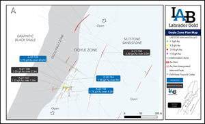
Figure 1.

Doyle Zone plan map.

TORONTO, June 07, 2022 (GLOBE NEWSWIRE) — Labrador Gold Corp. (TSX.V:LAB | OTCQX:NKOSF | FNR: 2N6) (“LabGold” or the “Company”) is pleased to announce results from seven drill holes, including the first hole drilled at the Golden Glove Target in the south end of its 100% owned Kingsway project near Gander, Newfoundland. These holes were drilled as part of the Company’s ongoing 100,000 metre drill program at Kingsway.

Hole K-22-150 intersected 6.22 g/t Au over 4 metres that included 10.31 g/t Au over 2m at a vertical depth of 246 metres. This intersection is located approximately 160 m south of the Golden Glove discovery outcrop where six grab samples, three of which contained visible gold, assayed between 2.99 g/t and 338.1 g/t Au (see news release dated September 21, 2021). This intersection at Golden Glove is the fourth of four targets drilled by LabGold to return significant gold intercepts.

While there are many similarities between the mineralization observed at Golden Glove and that at Big Vein, a significant difference is that while Big Vein occurs on the west side of the Appleton Fault Zone, Golden Glove is situated on the East Side. This is the first drilling on the east side of the fault at the Kingsway Property.https://embed.fireplace.yahoo.com/embed?ctrl=Monalixa&m_id=monalixa&m_mode=document&site=sports&os=android&pageContext=%257B%2522ctopid%2522%253A%25221542500%253B1577000%2522%252C%2522hashtag%2522%253A%25221542500%253B1577000%2522%252C%2522wiki_topics%2522%253A%2522Labrador%253BFault_(geology)%253BGold%2522%252C%2522lmsid%2522%253A%2522a0770000002m0AbAAI%2522%252C%2522revsp%2522%253A%2522globenewswire.com%2522%252C%2522lpstaid%2522%253A%252256728853-316a-31bc-a98d-be02627be93e%2522%252C%2522pageContentType%2522%253A%2522story%2522%257D

Six holes drilled at the Pristine target intersected near surface gold mineralization over significant widths in the Doyle Zone, including 1.86 g/t Au over 8m in hole K-22-144 and 1.75 g/t over 20.2m that included 2.76 g/t Au over 6.2m in Hole K-22-139.

“We are very pleased with the results from the first hole drilled at Golden Glove especially considering that the intersection is approximately 160m south of the discovery outcrop. This indicates excellent potential for the area between this hole and the outcrop and we are certainly looking forward to the results from the remaining five holes drilled there to date,” said Roger Moss, President and CEO of LabGold. “The continued near surface gold intercepts extending the strike length of the Doyle Zone are nice to see especially those with wider intersections. We are encouraged by the successful drilling of our four initial targets, all of which have delivered significant gold mineralization. We will continue to test the new targets developed along the Appleton Fault Zone through the summer, starting with the CSAMT target approximately eight kilometres northeast of Big Vein.”

Hole IDFrom (m)To (m)Interval (m)Au (g/t)Zone
K-22-1526670.244.241.78Doyle
 879032.24
 939631.17
K-22-15034835246.22Golden Glove
including348350210.31
K-22-149131411.27Doyle
K-22-1465757.950.951.12Doyle
K-22-144647281.86Doyle
including697123.32
K-22-14392.2930.81.42Doyle
K-22-13957.277.420.21.75Doyle
including62.268.46.22.76
 89.492.431.59

Table 1. Summary of Assay Results. All intersections are downhole length
as there is insufficient Information to calculate true width.

Hole numberEastingNorthingElevationAzimuthDipDepth
K-22-15266180454360205430050221
K-22-15066053954317764826545452.57
K-22-14966180454360216226045227
K-22-14666180354360326426062176
K-22-14466180854360706528045200.27
K-22-14366180154360345426045299.06
K-22-13966180254360335430045215

Table 2. Drill hole collar details

Figure 1. Doyle Zone plan map.

https://www.globenewswire.com/NewsRoom/AttachmentNg/5909d35d-b977-40ba-81da-f664988cc5e1

QA/QC

True widths of the reported intersections have yet to be calculated. Assays are uncut. Samples of HQ split core are securely stored prior to shipping to Eastern Analytical Laboratory in Springdale, Newfoundland for assay. Eastern Analytical is an ISO/IEC17025 accredited laboratory. Samples are routinely analyzed for gold by standard 30g fire assay with atomic absorption finish as well as by ICP-OES for an additional 34 elements. Samples containing visible gold are assayed by metallic screen/fire assay, as are any samples with fire assay results greater than 1g/t Au. The company submits blanks and certified reference standards at a rate of approximately 5% of the total samples in each batch.

Qualified Person

Roger Moss, PhD., P.Geo., President and CEO of LabGold, a Qualified Person in accordance with Canadian regulatory requirements as set out in NI 43-101, has read and approved the scientific and technical information that forms the basis for the disclosure contained in this release.

The Company gratefully acknowledges the Newfoundland and Labrador Ministry of Natural Resources’ Junior Exploration Assistance (JEA) Program for its financial support for exploration of the Kingsway property.

About Labrador Gold
Labrador Gold is a Canadian based mineral exploration company focused on the acquisition and exploration of prospective gold projects in Eastern Canada.

In early 2020, Labrador Gold acquired the option to earn a 100% interest in the Kingsway project in the Gander area of Newfoundland. The three licenses comprising the Kingsway project cover approximately 12km of the Appleton Fault Zone which is associated with gold occurrences in the region, including those of New Found Gold immediately to the south of Kingsway. Infrastructure in the area is excellent located just 18km from the town of Gander with road access to the project, nearby electricity and abundant local water. LabGold is drilling a projected 50,000 metres targeting high-grade epizonal gold mineralization along the Appleton Fault Zone following encouraging early results. The Company has approximately $28 million in working capital and is well funded to carry out the planned program.

The Hopedale property covers much of the Florence Lake greenstone belts that stretches over 60 km. The belt is typical of greenstone belts around the world but has been underexplored by comparison. Work to date by Labrador Gold show gold anomalies in rocks, soils and lake sediments over a 3 kilometre section of the northern portion of the Florence Lake greenstone belt in the vicinity of the known Thurber Dog gold showing where grab samples assayed up to 7.8g/t gold. In addition, anomalous gold in soil and lake sediment samples occur over approximately 40 km along the southern section of the greenstone belt (see news release dated January 25th 2018 for more details). Labrador Gold now controls approximately 40km strike length of the Florence Lake Greenstone Belt.

The Company has 159,199,026 common shares issued and outstanding and trades on the TSX Venture Exchange under the symbol LAB.

For more information please contact:

Roger Moss, President and CEOTel: 416-704-8291

Or visit our website at: www.labradorgold.com

Twitter: @LabGoldCorp

Neither TSX Venture Exchange nor its Regulation Services Provider (as that term is defined in policies of the TSX Venture Exchange) accepts responsibility for the adequacy or accuracy of this release.

Forward-Looking Statements: This news release contains forward-looking statements that involve risks and uncertainties, which may cause actual results to differ materially from the statements made. When used in this document, the words “may”, “would”, “could”, “will”, “intend”, “plan”, “anticipate”, “believe”, “estimate”, “expect” and similar expressions are intended to identify forward-looking statements. Such statements reflect our current views with respect to future events and are subject to risks and uncertainties. Many factors could cause our actual results to differ materially from the statements made, including those factors discussed in filings made by us with the Canadian securities regulatory authorities. Should one or more of these risks and uncertainties, such as actual results of current exploration programs, the general risks associated with the mining industry, the price of gold and other metals, currency and interest rate fluctuations, increased competition and general economic and market factors, occur or should assumptions underlying the forward looking statements prove incorrect, actual results may vary materially from those described herein as intended, planned, anticipated, or expected. We do not intend and do not assume any obligation to update these forward-looking statements, except as required by law. Shareholders are cautioned not to put undue reliance on such forward-looking statements.

Categories
Junior Mining Lion One Metals Precious Metals Uncategorized

Lion One Discovers Major New Gold Feeder Structure – 20.86 G/t Au over 75.9 Meters at Depth Beneath the Current Resource at Tuvatu, Fiji

North Vancouver, British Columbia–(Newsfile Corp. – June 6, 2022) – Lion One Metals Limited (TSXV: LIO) (OTCQX: LOMLF) (ASX: LLO) (“Lion One” or the “Company”) is delighted to announce the discovery of a major new feeder structure at its Tuvatu Alkaline Gold Project in Fiji. Hole TUG-141, targeting a complex network of high-grade structures called the 500 Zone, has encountered the longest high-grade intercept yet recorded at Tuvatu, 20.86 g/t Au over 75.9m, including 43.62 g/t Au over 30.0m which includes 90.35 g/t Au over 7.2m. The new discovery is located at depth beneath the current resource fully within the permit boundaries of the Tuvatu mining lease.

High-grade intercepts from TUG-141 include:

  • 20.86 g/t Au over 75.9m from 443.4-519.3m
  • including 35.25 g/t Au over 37.5m from 471.3-508.8m
  • including 43.62 g/t Au over 30.0m from 477.6-507.6m
  • including 90.35 g/t Au over 7.2m from 494.4-501.6m
  • and notable individual high-grade assay intervals including:

– 138.15 g/t Au over 0.30m from 450.9-451.2m

– 396.16 g/t Au over 0.30m from 479.1-479.4m

– 103.54 g/t Au over 0.30m from 498.6-498.9m

– 340.07 g/t Au over 0.30m from 498.9-499.2m

– 600.42 g/t Au over 0.30m from 499.5-499.8m

– 244.37 g/t Au over 0.30m from 502.5- 503.1m

– 230.18 g/t Au over 0.30m from 507.3-507.6m

– 105.58 g/t Au over 0.30m from 518.7-519.0m

Lion One CEO, Walter Berukoff, stated: “Like the initial discovery of the high-grade 500 Zone drilled two years ago, I believe this new robust high-grade gold feeder mineralization encountered by hole TUG-141 represents a substantial discovery for Lion One. The notable high grades and continuity of mineralization of this intercept demonstrate Tuvatu’s potential to become a large-scale, high-grade underground gold mine. I have long encouraged our team to find that “gold room” at Tuvatu, and hole TUG-141 leads me to believe they have found it. We have only to look at other notable large alkaline Au deposits as direct analogues to better understand what this latest discovery tells us, and it is clear that the discovery of a major high-grade feeder such as this should be viewed as very promising. I am confident that Tuvatu will one day fall in the ranks of notable multi-million ounce Au deposits such as Porgera and Vatukoula. I commend our team on this truly outstanding discovery and I look forward to continued successful execution of both our exploration strategy to realize growth at Tuvatu and our development strategy targeting the commencement of gold production in the second half of 2023.”

Lion One Senior VP of Exploration, Sergio Cattalani, commented: “The mineralized intercepts reported by TUG-141 represent a highly significant development. The grades and continuity observed by the intercepts in hole TUG-141 are of a magnitude not previously documented at Tuvatu, and highlights the largely untapped potential of this deposit. The significance of having identified what may be a new principal feeder conduit for Tuvatu confirms the model that has driven this deep exploration program since the discovery of hole TUDDH-500 in July 2020. Our immediate priority is to follow up of this significant discovery with additional drilling in what remains a relatively poorly drilled portion of the Tuvatu system. Lion One, is now more than ever, convinced of the potential of Tuvatu to become a prominent, multi-million ounce Au deposit at the top of the Au grade distribution worldwide.”

Lion One Technical Advisor, Quinton Hennigh, commented: “Alkaline gold systems tend to be deep-rooted and very structurally complex. Exploring them can be analogous to drilling a tree from the top down. In the shallow part of the system, one finds the upper “branches,” or gold-bearing lodes, but as exploration persists to depth, bigger and bigger “branches,” or lodes, are encountered ultimately leading to the “trunk,” the feeder. The way this remarkable discovery at Tuvatu has unfolded is quite similar to the experience at Porgera, where after approximately ten years of diligent drilling, the high-grade Romane Fault Zone was discovered beneath a myriad of smaller lodes. What is most exciting about this discovery is that now that we have a clear idea where the deep fluid-tapping conduit of this system is located, we can effectively chase it to depth, and alkaline gold systems are known to persist to great depths, sometimes as deep as 2 km. Considering this intercept is only approximately 500m below surface, this discovery is wide open for growth at depth.”

TUG-141 was drilled in the area between modelled 500 Zone lodes 500A, 500C and 500F (Figure 1) where it intersected continuous high-grade Au mineralization grading 20.86 g/t Au over 75.9m that is predominantly hosted by intensely altered, fractured and brecciated andesite. The highest grade core of this zone is characterized by hydrothermal breccia displaying extreme silicification, potassic alteration and sulfidation with regular occurrences of visible gold (Figure 2). In addition, the presence of abundant roscoelite (a vanadium mica mineral) is very encouraging and is a mineral synonymous with the high-grade zones of world-class alkali gold systems such as Cripple Creek in Colorado and Porgera in Papua New Guinea. Some fragments within portions of this breccia are visibly milled, or rounded, indicating vigorous fluid flow. Observations of fracture patterns and textures ranging from incipient and in-situ to full-on brecciation (Figure 2) point to this zone being a dilational breccia that likely formed along a major structural intersection where stresses were being released at the time of mineralization. Rapid depressurisation accompanying seismic movement along such a dilational zone would allow rapid ascent of hydrothermal fluids resulting in silicification, K-metasomatism, sulfidation and rapid precipitation of Au. Textures of minerals observed in veins and open spaces is consistent with a rapid depositional regime.

Lion One is concurrently undertaking a two-pronged exploration drill campaign: 1) shallow infill drilling to enhance definition of its current resource in preparation for mine planning, and 2) deep drilling focussed on better understanding the geometry and extent of the underlying high-grade feeder network. As part of the latter program, hole TUG-141 targeted the upper portion of the 500 Zone at depths between approximately 450-550m where it is projected to connect with the base of lodes making up the Inferred resource. As discussed above, TUG-141 drilled into a very wide and exceptionally high-grade zone, 20.86 g/t Au over 75.9m, cored by hydrothermal breccia (Figure 2). Such a zone of extreme fracturing and brecciation has never before been observed at Tuvatu. It is significant to note that the bulk of this mineralized interval is hosted within andesite rather than by intrusive monzonite, the typical host rock for many lodes at Tuvatu. The significance of this observation has yet to be determined.

Furthermore, it is also notable that the nearest drill holes to TUG-141 are TUG-135 (70m below), TUG-136 (45m to the E), and TUG-138 (60m to the W), indicating that there is considerable space for a substantial increase in the ultimate size of the feeder conduit. All three of these holes have returned previously reported bonanza grade mineralization, similar in tenor and texture to that in TUG-141, including:

24.92 g/t Au over 3.70m from 415.7-419.4m in hole TUG-135 including 159.3 g/t Au over 0.30m;

87.83 g/t Au over 1.5m from 445.1-446.6m in hole TUG-136 including 108.41 g/t Au over 0.60m;

and 23.14 g/t Au over 3.0m from 571.5-574.5m in hole TUG-138 including 118.6 g/t Au over 0.30m.

The area remains open at depth. This target has now become of utmost importance for follow up drilling.

In addition to the impressive intercept of 20.86 g/t Au over 75.9m discussed above, hole TUG-141 encountered numerous other significant mineralized intercepts both above and below this interval including:

Above the high-grade intercept

  • 3.93 g/t Au over 5.7m from 101.7-107.4m including 12.17 g/t Au over 0.30m
  • 4.48 g/t Au over 10.2m from 109.8-120.0m including 38.27 g/t Au over 0.30m
  • 10.98 g/t Au over 1.5m from 291.3-292.8m including 17.20 g/t Au over 0.60m
  • 5.63 g/t Au over 19.2m from 311.7-330.9m including 20.50 g/t Au over 3.00m from 322.2-325.2m, which includes 71.01 g/t Au over 0.30m and 13.75 g/t Au over 0.60m
  • 3.33 g/t Au over 4.50m from 366.3-370.8m including 7.40 g/t Au over 1.20m
  • 11.38 g/t Au over 2.1m from 380.7-382.8m including 22.30 g/t Au over 0.90m
  • 1.97 g/t Au over 13.5m from 391.8-405.3m including 15.25 g/t Au over 0.30m
  • 2.82 g/t Au over 3.90m from 425.1-429.0m including 8.47 g/t Au over 0.30m

Below the high-grade intercept

  • 3.08 g/t Au over 1.50m from 524.1-525.6m including 7.50 g/t Au over 0.30m

In aggregate, all mineralized intercepts reported from hole TUG-141 total 1,909 g/t Au-meters.

Complete results, received to date, from hole TUG-141 are summarized below in Table 1. This is the first drill hole in this part of the Tuvatu alkaline gold system, and as such, orientation and true thicknesses of mineralized intercepts discussed above are not known at this time. Further drilling is required to better understand this new discovery. At the time of writing, hole TUG-141 is still being drilled, and is currently >600m in depth with other mineralised structures yet to be assayed.


Figure 1. Plan view (upper) and vertical section looking E (lower) of the trace of TUG-141 and selected drill holes relative to the 500 Zone lodes modeled to date. TUG-141 was drilled from underground along the Tuvatu exploration decline. The traces of known lodes UR2 and UR4, and modelled lodes of the 500 Zone feeder are shown in red.

To view an enhanced version of Figure 1, please visit:
https://orders.newsfilecorp.com/files/2178/126617_fig%201ed%20lm.jpg.


Figure 2. Compilation of photographs from TUG-141. (A) Abundant visible gold grains (0.2-2mm) in highly altered potassium metasomatized groundmass and roscoelite. (B) Visible gold (~2mm grains) associated with coarse pyrite in a silicified breccia. (C & D) Intensely silicified and pyritized andesite with microfractures of visible gold (~0.5mm grains).

To view an enhanced version of Figure 2, please visit:
https://orders.newsfilecorp.com/files/2178/126617_81354d06c4e0dad0_003full.jpg.


Figure 2 (continued). (E) Vuggy breccia with coarse pyrite and silicified-sulfidized ground mass. Breccia clasts are angular to sub-rounded. (F) Coarse pyrite breccia with silicified-sulfidized ground mass. (G) Network fracture stockwork ~1-5mm veins with two generations of pyrite. The clasts are highly altered silicified andesite, with the veins containing quartz-pyrite. (H) Network fracture stockwork veins at multiple angles, with intense silicification, quartz-carbonate infill and pyrite.

To view an enhanced version of Figure 2 continued, please visit:
https://orders.newsfilecorp.com/files/2178/126617_81354d06c4e0dad0_004full.jpg.

Mineralization is observed as two generations of pyrite; an earlier bright euhedral pyrite that forms coarse crystals in the core of the veins and breccia, and a darker brownish, spongy pyrite that typically forms extremely fine-grained encrustations or overgrowths on earlier pyrite and wallrock fragments, as well as lining the edges of most veins (Figure 2). Quartz occurs commonly as bluish grey, amorphous to locally colloform silica. Open space vuggy textures are common, as are visible gold grains. Highest grades (up to 600 g/t Au) appear to be associated with an interval of intense pervasive silicification and sulfidation by up to 30% or more extremely fine-grained pyrite developed throughout the host rock, giving the rock an overall massive chocolate brown appearance (Figure 2). The intensity of replacement suggests this is a zone of very high and sustained fluid flux.

Table 1: Table showing all drilling intervals returning >0.5 g/t Au for hole TUG-141. Intervals > 3.0 g/t Au, which is the cutoff grade used for the current resource, are shown in red, and intervals >9.0 g/t Au, which is the average grade of the resource, are bolded.

Sample IDFrom (m)To (m)Interval (m)Grade (g/t Au)
TUG0858471.7720.30.96
TUG08535101.71020.33.96
TUG08536102102.30.312.17
TUG08537102.3102.60.35.35
TUG08538102.6102.90.31.42
TUG08539102.9103.20.33.09
TUG08541103.5103.80.31.19
TUG08542103.8104.10.38.64
TUG08543104.1104.40.37.67
TUG08544104.4104.70.37.56
TUG08545104.71050.37.90
TUG08546105105.30.33.53
TUG08548105.6105.90.30.60
TUG08549105.9106.50.64.83
TUG08452107.1107.40.31.42
TUG08456109.8110.10.315.41
TUG08457110.1110.40.30.74
TUG08458110.4110.70.31.12
TUG08459110.71110.35.28
TUG08460111111.30.30.80
TUG08462111.6111.90.32.66
TUG08463111.9112.20.31.45
TUG08464112.2112.50.31.22
TUG08466112.5112.80.31.50
TUG08467112.8113.10.32.67
TUG08468113.1113.40.33.47
TUG08469113.4113.70.32.92
TUG08470113.71140.32.93
TUG08471114114.30.38.74
TUG08473114.6114.90.37.36
TUG08474114.9115.50.60.90
TUG08475115.5115.80.37.20
TUG08476115.8116.10.33.14
TUG08477116.1116.40.30.92
TUG08479116.71170.33.62
TUG08481117117.30.315.85
TUG08482117.3117.60.32.06
TUG08483117.6117.90.31.95
TUG08484117.9118.20.30.58
TUG08485118.2118.50.35.51
TUG08486118.5118.80.36.35
TUG08487118.8119.10.338.27
TUG08488119.1119.40.33.02
TUG08489119.4119.70.31.41
TUG08490119.71200.32.19
TUG08494122.4122.70.31.35
TUG08946213.6213.90.32.11
TUG08947213.9214.20.30.97
TUG08948214.2214.50.33.03
TUG09446214.5214.80.30.82
TUG08949214.8215.10.31.50
TUG09401215.1215.40.31.61
TUG09402215.4215.70.31.75
TUG09407216.9217.20.33.22
TUG09408217.2217.50.30.18
TUG09409217.5217.80.30.62
TUG09423222.9223.20.30.72
TUG09432226.5226.80.31.41
TUG09444233.4233.70.31.32
TUG09445233.72340.33.13
TUG09447234234.30.36.30
TUG09448234.3234.60.32.08
TUG09529274.8275.10.30.77
TUG09536276.6276.90.30.59
TUG09540277.8278.10.30.64
TUG09566291.3291.60.314.77
TUG09567291.6291.90.34.01
TUG09568291.9292.20.316.55
TUG09569292.2292.50.317.85
TUG09570292.5292.80.31.75
TUG09582299.1299.40.32.12
TUG09583299.4299.70.31.94
TUG09584299.73000.30.63
TUG09585300300.30.31.13
TUG09586300.3300.60.30.99
TUG09587300.6300.90.30.79
TUG09588300.9301.20.34.31
TUG09591301.8302.10.31.58
TUG09594302.73030.30.92
TUG09595303303.30.30.78
TUG09605308.1308.40.31.28
TUG09614311.73120.31.35
TUG09616312312.30.32.61
TUG09617312.3312.60.30.08
TUG09619313.2313.50.34.56
TUG09620313.5313.80.33.54
TUG09621313.8314.10.32.47
TUG09622314.1314.40.31.65
TUG09625315.3315.60.31.25
TUG09626315.6315.90.37.71
TUG09628316.8317.10.30.54
TUG09629317.1317.40.32.57
TUG09631317.4317.70.31.00
TUG09633318318.30.31.42
TUG09634318.3318.60.33.11
TUG09635318.6318.90.35.42
TUG09636318.9319.20.34.25
TUG09637319.2319.50.37.68
TUG09638319.5319.80.35.78
TUG09639319.8320.10.30.85
TUG09641320.4320.70.33.19
TUG09642320.73210.33.49
TUG09643321321.30.37.93
TUG09644321.3321.60.32.40
TUG09645321.6321.90.32.04
TUG09646321.9322.20.37.42
TUG09647322.2322.50.318.75
TUG09648322.5322.80.312.75
TUG09650322.8323.10.312.55
TUG09651323.1323.40.315.64
TUG09652323.4323.70.319.67
TUG09653323.73240.313.55
TUG09654324324.30.315.18
TUG09655324.3324.60.311.27
TUG09656324.6324.90.314.62
TUG09657324.9325.20.371.01
TUG09658325.2325.50.35.61
TUG09659325.5326.40.90.60
TUG09660326.4326.70.33.97
TUG09661326.73270.34.93
TUG09662327327.30.311.64
TUG09663327.3327.60.315.86
TUG09667328.5329.40.90.98
TUG09668329.4329.70.32.77
TUG09669329.73300.32.58
TUG09670330330.30.36.51
TUG09671330.3330.60.34.28
TUG09672330.6330.90.36.21
TUG09694345.3345.60.30.60
TUG09695345.6345.90.34.62
TUG09696345.9346.20.34.07
TUG09697346.2346.50.31.76
TUG09699346.8347.10.32.13
TUG09703348.3348.60.333.25
TUG09704348.6348.90.33.52
TUG09703348.3348.60.333.25
TUG09707350.1350.40.312.62
TUG09710351.3351.60.33.20
TUG09711351.6351.90.30.51
TUG09733366.3366.60.31.26
TUG09734366.6366.90.32.37
TUG09736367.5367.80.30.80
TUG09737367.8368.10.311.02
TUG09738368.1368.40.37.96
TUG09739368.4368.70.33.68
TUG09740368.73690.36.95
TUG09741369369.30.31.82
TUG09742369.3369.60.31.29
TUG09744369.9370.20.34.11
TUG09745370.2370.50.33.89
TUG09746370.5370.80.34.54
TUG09759380.73810.32.63
TUG09760381381.60.623.15
TUG09761381.6381.90.320.60
TUG09762381.9382.20.36.13
TUG09763382.2382.50.33.37
TUG09764382.5382.80.30.64
TUG09777391.8392.10.31.08
TUG09778392.1392.40.31.08
TUG09779392.4392.70.30.89
TUG09781392.73930.30.55
TUG09783393.6393.90.30.65
TUG09784393.9394.20.30.54
TUG09785394.2394.50.32.90
TUG09786394.5394.80.32.34
TUG09787394.8395.10.33.74
TUG09788395.1395.40.32.82
TUG09789395.4395.70.31.98
TUG09790395.73960.31.55
TUG09792396.3396.60.32.25
TUG09794396.9397.20.30.44
TUG09795397.2397.50.31.78
TUG09796397.5397.80.33.20
TUG09797397.8398.10.31.27
TUG09798398.1398.40.315.27
TUG09799398.4398.70.32.96
TUG09801398.73990.35.34
TUG09802399399.30.32.38
TUG09803399.3399.60.32.93
TUG09804399.6400.50.94.00
TUG09805400.5400.80.30.68
TUG09806400.8401.10.32.41
TUG09807401.1401.40.32.06
TUG09808401.4401.70.31.61
TUG09809401.74020.31.67
TUG09811402.3402.60.31.46
TUG09812402.6402.90.30.91
TUG09814403.2403.50.33.71
TUG09817403.8404.10.30.77
TUG09819405405.30.31.56
TUG09811402.3402.60.31.40
TUG09812402.6402.90.30.95
TUG09814403.2403.50.33.57
TUG09817403.8404.10.30.83
TUG09819405405.30.31.61
TUG09824406.8407.10.32.78
TUG09827408408.30.31.21
TUG09828408.3408.60.30.72
TUG09829408.6409.20.61.14
TUG09831409.2409.50.33.27
TUG09832409.5409.80.30.90
TUG09836410.74110.31.86
TUG09837411411.30.32.11
TUG09838411.3411.60.33.40
TUG09839411.6411.90.30.70
TUG09842412.8413.10.30.93
TUG09843413.1413.40.30.76
TUG09848416.14170.90.63
TUG10354418.8419.10.30.82
TUG10355419.1419.40.30.65
TUG10360420.6420.90.30.75
TUG10361420.9421.20.31.05
TUG10362421.2421.50.31.59
TUG10363421.5421.80.31.23
TUG10367422.74230.30.68
TUG10368423423.30.30.72
TUG10373425.1425.40.32.48
TUG10374425.4425.70.32.83
TUG10375425.74260.33.52
TUG10376426426.30.33.77
TUG10377426.3426.60.38.47
TUG10378426.6426.90.31.64
TUG10379426.9427.20.31.53
TUG10381427.2427.80.64.11
TUG10382427.8428.10.31.65
TUG10383428.14290.90.86
TUG10387429.9430.20.30.72
TUG10393433.2433.50.32.04
TUG10394433.5433.80.30.85
TUG10395433.8434.10.30.76
TUG10408440.4440.70.32.36
TUG10413443.1443.40.31.02
TUG10414443.4443.70.36.82
TUG10417444.9445.20.317.94
TUG10418445.2445.50.35.83
TUG10423447447.30.31.16
TUG10425448.2448.50.34.54
TUG10426448.5448.80.30.76
TUG10428450450.30.34.94
TUG10429450.3450.60.31.53
TUG10431450.6450.90.30.97
TUG10432450.9451.20.3138.15
TUG10434451.5451.80.30.76
TUG10435451.8452.10.31.25
TUG10436452.1452.40.31.35
TUG10438452.74530.31.65
TUG10439453453.30.34.70
TUG10440453.3453.60.32.57
TUG10441453.6453.90.34.99
TUG10444454.8455.10.314.02
TUG10445455.1455.40.32.07
TUG10446455.4455.70.31.09
TUG10447455.74560.31.28
TUG10448456456.30.32.55
TUG10453459460.21.21.14
TUG10454460.2460.80.61.00
TUG10455460.84621.21.74
TUG10456462462.30.31.28
TUG10457462.3462.60.324.98
TUG10458462.6462.90.387.13
TUG10459462.9463.80.911.34
TUG10461464.44650.60.67
TUG10463465.9466.20.30.91
TUG10464466.2466.50.31.36
TUG10466466.5466.80.31.27
TUG10467466.8467.10.31.28
TUG10468467.1467.40.33.79
TUG10469467.4467.70.320.93
TUG10470467.74680.320.64
TUG10471468468.30.319.40
TUG10473468.6468.90.33.46
TUG10474468.9469.20.32.78
TUG10475469.2469.50.32.10
TUG10482471.3471.60.30.81
TUG10483471.6471.90.31.03
TUG10484471.9472.20.36.72
TUG10485472.2472.50.30.88
TUG10486472.5472.80.31.45
TUG10487472.8473.10.39.05
TUG10488473.1473.40.31.35
TUG10490473.74740.30.48
TUG10492474.3474.60.30.78
TUG10493474.6474.90.31.37
TUG10494474.9475.20.31.43
TUG10496475.5475.80.31.67
TUG10497475.84771.21.80
TUG10498477477.60.62.64
TUG10500477.6477.90.393.49
TUG10501477.9478.20.31.01
TUG10502478.2478.50.334.17
TUG10503478.5478.80.394.57
TUG10504478.8479.10.335.04
TUG10505479.1479.40.3396.16
TUG10506479.4479.70.325.06
TUG10507479.74800.37.09
TUG10508480480.30.34.06
TUG10509480.3480.60.331.63
TUG10510480.6480.90.35.3
TUG10511480.9481.20.3114.95
TUG10512481.2481.50.31.90
TUG10513481.5481.80.30.83
TUG10514481.8482.10.39.99
TUG10516482.1482.40.30.71
TUG10517482.4482.70.36.64
TUG10518482.74830.36.05
TUG10519483483.30.36.64
TUG10520483.3483.60.32.47
TUG10521483.6483.90.30.93
TUG10522483.9484.20.35.15
TUG10523484.2484.50.310.90
TUG10524484.5484.80.314.76
TUG10525484.8485.10.320.24
TUG10526485.1485.40.321.93
TUG10527485.4485.70.320.79
TUG10528485.74860.332.89
TUG10529486486.30.316.13
TUG10531486.3486.60.32.55
TUG10532486.6486.90.313.04
TUG10533486.9487.20.35.42
TUG10534487.2487.50.33.95
TUG10535487.5487.80.34.89
TUG10536487.8488.10.34.24
TUG10537488.1488.40.34.41
TUG10538488.4488.70.35.21
TUG10539488.74890.31.80
TUG10540489489.30.316.42
TUG10541489.3489.60.37.17
TUG10542489.6489.90.36.47
TUG10543489.9490.20.34.07
TUG10544490.2490.50.34.75
TUG10545490.5490.80.34.86
TUG10546490.8491.10.37.13
TUG10547491.1491.40.311.64
TUG10548491.4491.70.335.68
TUG10549491.74920.322.53
TUG10551492492.30.310.72
TUG10552492.3492.60.325.23
TUG10553492.6492.90.316.77
TUG10554492.9493.20.320.86
TUG10555493.2493.50.323.61
TUG10556493.5493.80.35.85
TUG10557493.8494.10.36.41
TUG10558494.1494.40.34.25
TUG10559494.4494.70.336.13
TUG10560494.74950.319.66
TUG10561495495.30.372.65
TUG10562495.3495.60.3241.21
TUG10563495.6495.90.331.77
TUG10564495.9496.20.351.52
TUG10566496.2496.50.325.17
TUG10567496.5496.80.3100.35
TUG10568496.8497.10.312.86
TUG10569497.1497.40.34.68
TUG10570497.4497.70.333.81
TUG10571497.74980.337.11
TUG10572498498.30.320.74
TUG10573498.3498.60.326.29
TUG10574498.6498.90.3103.54
TUG10575498.9499.20.3340.07
TUG10576499.2499.50.3269.25
TUG10577499.5499.80.3600.42
TUG10578499.8500.10.373.02
TUG10579500.1500.40.313.41
TUG10581500.4500.70.31.85
TUG10582500.7501.30.613.32
TUG10583501.3501.60.326.54
TUG10584501.6501.90.39.04
TUG10585501.9502.20.34.79
TUG10586502.2502.50.33.93
TUG10587502.5502.80.3126.85
TUG10588502.8503.10.3361.90
TUG10589503.1503.40.31.95
TUG10590503.4503.70.33.27
TUG10591503.75040.332.78
TUG10592504504.30.323.63
TUG10596505.2505.50.38.07
TUG10598505.8506.10.318.51
TUG10599506.1506.40.353.78
TUG10602506.75070.37.50
TUG10604507.3507.60.3234.39
TUG10605507.6507.90.32.22
TUG10606507.9508.80.90.58
TUG10612510.3510.60.33.37
TUG10613510.6510.90.31.32
TUG10614510.9511.20.35.53
TUG10616511.2511.50.324.91
TUG10617511.5511.80.364.47
TUG10618511.8512.10.372.56
TUG10619512.1512.40.313.35
TUG10620512.4512.70.32.08
TUG10621512.75130.31.59
TUG10622513513.30.30.74
TUG10623513.3513.60.30.94
TUG10624513.6513.90.30.53
TUG10625513.9514.20.31.17
TUG10626514.2514.50.323.17
TUG10627514.5514.80.30.85
TUG10628514.8515.10.32.39
TUG10629515.1515.40.31.03
TUG10631515.4515.70.30.83
TUG10632515.75160.31.74
TUG10633516516.30.33.50
TUG10634516.3516.60.30.59
TUG10636516.9517.20.30.80
TUG10637517.2517.50.32.99
TUG10638517.5517.80.30.76
TUG10639517.8518.10.33.34
TUG10640518.1518.40.38.94
TUG10641518.4518.70.312.80
TUG10642518.75190.3105.58
TUG10643519519.30.334.42
TUG10644519.3519.60.30.55
TUG10645519.6519.90.30.80
TUG10656522.6522.90.30.59
TUG10657522.9523.20.30.88
TUG10658523.2523.50.30.76
TUG10659523.5523.80.31.09
TUG10660523.8524.10.30.61
TUG10661524.1524.40.32.11
TUG10664525525.30.35.56
TUG10666525.3525.60.37.50
TUG10667525.6525.90.30.87
TUG10668525.9526.20.30.78
TUG10693543.9544.20.30.63
TUG10695544.5544.80.30.75
TUG10696544.8545.10.30.59
TUG10699545.75460.30.81
TUG10701546546.30.30.63
TUG10702546.3546.60.30.59
TUG10706547.5547.80.30.52
TUG10719554.1554.40.30.84

Table 2: Survey details of diamond drill holes referenced in this release

Hole NoCoordinates (Fiji map grid)RLfinal depthdipazimuth
NEm(TN)
TUG-13539207591876459139.2689.4-64149
TUG-13639207591876459139.2617.4-58151
TUG-13839207591876459139.2746.4-64163
TUG-14139207591876459139.2633.0 *-55°162°

* Current depth, hole is still drilling

Qualified Person
In accordance with National Instrument 43-101 – Standards of Disclosure for Mineral Projects (“NI 43-101”), Sergio Cattalani, P.Geo, Senior Vice President Exploration, is the Qualified Person for the Company and has reviewed and is responsible for the technical and scientific content of this news release.

QAQC Procedures
Lion One adheres to rigorous QAQC procedures above and beyond basic regulatory guidelines in conducting its sampling, drilling, testing, and analyses. The Company utilizes its own fleet of diamond drill rigs, using PQ, HQ and NQ sized drill core rods. Drill core is logged and split by Lion One personnel on site. Samples are delivered to and analysed at the Company’s geochemical and metallurgical laboratory in Fiji. Duplicates of all samples with grades above 0.5 g/t Au are both re-assayed at Lion One’s lab and delivered to ALS Global Laboratories in Australia (ALS) for check assay determinations. All samples for all high-grade intercepts are sent to ALS for check assays. All samples are pulverized to 80% passing through 75 microns. Gold analysis is carried out using fire assay with an AA finish. Samples that have returned grades greater than 10.00 g/t Au are then re-analysed by gravimetric method. For samples that return greater than 0.50 g/t Au, repeat fire assay runs are carried out and repeated until a result is obtained that is within 10% of the original fire assay run. For samples with multiple fire assay runs, the average of duplicate runs is presented. Lion One’s laboratory can also assay for a range of 71 other elements through Inductively Coupled Plasma Optical Emission Spectrometry (ICP-OES), but currently focuses on a suite of 9 important pathfinder elements. All duplicate anomalous samples are sent to ALS labs in Townsville QLD and are analysed by the same methods (Au-AA26, and Au-GRA22 where applicable). ALS also analyses for 33 pathfinder elements by HF-HNO3-HClO4 acid digestion, HCl leach and ICP-AES (method ME-ICP61).

About Lion One Metals Limited
Lion One’s flagship asset is 100% owned, fully permitted high grade Tuvatu Alkaline Gold Project, located on the island of Viti Levu in Fiji. Lion One envisions a low-cost high-grade underground gold mining operation at Tuvatu coupled with exciting exploration upside inside its tenements covering the entire Navilawa Caldera, an underexplored yet highly prospective 7km diameter alkaline gold system. Lion One’s CEO Walter Berukoff leads an experienced team of explorers and mine builders and has owned or operated over 20 mines in 7 countries. As the founder and former CEO of Miramar Mines, Northern Orion, and La Mancha Resources, Walter is credited with building over $3 billion of value for shareholders.

On behalf of the Board of Directors of
Lion One Metals Limited
Walter Berukoff
Chairman and CEO

For further information
Contact Investor Relations
Toll Free (North America) Tel: 1-855-805-1250
Email: info@liononemetals.com
Website: www.liononemetals.com

Neither the TSX Venture Exchange nor its Regulation Service Provider
accepts responsibility for the adequacy or accuracy of this release.

This press release may contain statements that may be deemed to be “forward-looking statements” within the meaning of applicable Canadian securities legislation. All statements, other than statements of historical fact, included herein are forward-looking information. Generally, forward-looking information may be identified by the use of forward-looking terminology such as “plans”, “expects” or “does not expect”, “proposed”, “is expected”, “budget”, “scheduled”, “estimates”, “forecasts”, “intends”, “anticipates” or “does not anticipate”, or “believes”, or variations of such words and phrases, or by the use of words or phrases which state that certain actions, events or results may, could, would, or might occur or be achieved. This forward-looking information reflects Lion One Metals Limited’s current beliefs and is based on information currently available to Lion One Metals Limited and on assumptions Lion One Metals Limited believes are reasonable. These assumptions include, but are not limited to, the actual results of exploration projects being equivalent to or better than estimated results in technical reports, assessment reports, and other geological reports or prior exploration results. Forward-looking information is subject to known and unknown risks, uncertainties and other factors that may cause the actual results, level of activity, performance or achievements of Lion One Metals Limited or its subsidiaries to be materially different from those expressed or implied by such forward-looking information. Such risks and other factors may include, but are not limited to: the stage development of Lion One Metals Limited, general business, economic, competitive, political and social uncertainties; the actual results of current research and development or operational activities; competition; uncertainty as to patent applications and intellectual property rights; product liability and lack of insurance; delay or failure to receive board or regulatory approvals; changes in legislation, including environmental legislation, affecting mining, timing and availability of external financing on acceptable terms; not realizing on the potential benefits of technology; conclusions of economic evaluations; and lack of qualified, skilled labour or loss of key individuals. Although Lion One Metals Limited has attempted to identify important factors that could cause actual results to differ materially from those contained in forward-looking information, there may be other factors that cause results not to be as anticipated, estimated or intended. Accordingly, readers should not place undue reliance on forward-looking information. Lion One Metals Limited does not undertake to update any forward-looking information, except in accordance with applicable securities laws.

Categories
Uncategorized

Quebec Precious Metals drills La Pointe Extension: 0.84 g/t Au Over 63 m Downhole, Higher-Grade Core Extended +200 m at Depth, Open in All Directions

MONTREAL, QC / ACCESSWIRE / May 26, 2022 / Quebec Precious Metals Corporation (“QPM” or the “Company”) (TSXV:QPM)(OTCQB:CJCFF)(FSE:YXEP) is pleased to announce drill hole assay results from drill hole 189 and the six (6) drill holes from the 2022 winter program (7 holes, totalling 2,982 m). The results demonstrate the depth and strike extension of higher gold mineralization for an additional 200 m at the La Pointe Extension gold deposit, on the Company’s 100% owned Sakami project in the Eeyou Istchee James Bay territory of Quebec.

Highlights (Table 1, Figures 1, 2 and 3)

  • All seven (7) holes have intersected extensive mineralization over wide intervals.
  • The three most significant drill intersections are:
    • Hole PT-21-190: 1.61 g/t Au over 19.5 m including 4.91 g/t Au over 1.5 m
    • Hole PT-21-191: 0.84 g/t Au over 63.0 m including 1.25 g/t Au over 18.0 m
    • Hole PT-21-194: 0.94 g/t Au over 26.9 m including 1.77 g/t Au over 9.0 m
  • These holes confirm the continuity of the sub-vertically dipping higher-grade core of the deposit (500 m strike length, a depth of 600 m with an estimated average true thickness of
    40 m, up to 75 m in the central part of the deposit, and plunging about 45 degrees to the northeast) which could be amenable to open pit mining.

Normand Champigny, QPM’s Chief Executive Officer, stated: “These results show that the
La Pointe Extension deposit keeps expanding at depth and remains open in all directions. The drill results will add an important mineralized volume. In addition, we have numerous undrilled targets in interpreted large intrusive bodies near the deposit and over a strike length of 2.5 km to the south of the deposit. Additional drilling will be required to better define the mineralized zones and to optimize open pit geometries.

The 2021 fall and 2022 winter drilling aimed to expand the La Pointe Extension deposit that could be amenable to open pit mining. To date, a total of 47 holes (14,535 m) have intersected the
La Pointe Extension deposit.

The La Pointe Extension deposit and the La Pointe deposit are part of the Sakami project located along a 23-kilometre-long favourable geological contact that hosts gold mineralization. Both deposits are of similar geological character and a sub-vertically dipping higher-grade portion. They show a generally good spatial correlation between the gold mineralization and the abundance of disseminated arsenopyrite, pyrite and pyrrhotite hosted in a silicified paragneiss that is observed in drill holes. At the La Pointe deposit, the mineralized zone has a strike length 950 m, a depth of 450 m with an estimated average true thickness of 35 m, up to 63 m in the central part of the deposit.

Complete assay results and calculated composite grades released to date are available on QPM’s website (https://www.qpmcorp.ca/en/projects/sakami-technical-information/). For previously disclosed results in connection with the La Pointe and La Pointe Extension deposits, see press releases of June 9, 2021, November 2, 2021, February 24, 2022 and March 10, 2022.

Quality Assurance/Quality Control

The drilling contract was awarded to Orbit Garant Drilling Inc., based in Val-d’Or, Quebec. The hole diameter is NQ. Quality assurance and quality control procedures have been implemented to ensure best practices in sampling and analysis of the core samples. The drill core was logged and then split, with one-half sent for assay and the other retained in the core box as a witness sample. Duplicates, standards and blanks were regularly inserted into the sample stream. The samples were delivered, in secure tagged bags, directly to the ALS Minerals laboratory facility in Val-d’Or, Quebec. The samples are weighed and identified prior to sample preparation. All samples are analyzed by fire assay with AA finish on a 30 g sample (0.005-10 ppm Au), with a gravimetric finish for assays over 10 ppm Au.

The Sakami Project

The Sakami Project provides the Company with a controlling position over a 23-km long segment of a favourable geological contact and comprises 281 claims (142 km2). It is located 570 km north of Val d’Or, Quebec, 120 km east of the municipality of Wemindji, 90 km from the Éléonore gold mine and 47 km northeast of the paved James Bay Road. Good infrastructure, including major access roads, a hydro-powered electric grid and airports, are present in the region. Drilling can be carried out throughout the year.

Qualified Persons

Normand Champigny, Eng., Chief Executive Officer of the Company, and Qualified Person under NI 43-101 on standards of disclosure for mineral projects, has prepared and reviewed the content of this press release. François Gagnon, P. Geo., Senior Exploration Geologist with Consul-Teck Exploration Minière Inc. has also reviewed the content of this release.

About Quebec Precious Metals Corporation

QPM is a gold explorer with a large land position in the highly prospective Eeyou Istchee James Bay territory, Quebec, near Newmont Corporation’s Éléonore gold mine. QPM’s flagship project is the Sakami project with significant grades and well-defined drill-ready targets. QPM’s goal is to rapidly explore the Sakami project and advance to the mineral resource estimate stage.

For more information, please contact:

Normand Champigny
Chief Executive Officer
Tel.: 514 979-4746
Email: nchampigny@qpmcorp.ca

Neither TSX Venture Exchange nor its Regulation Services Provider (as that term is defined in the policies of the TSX Venture Exchange) accept responsibility for the adequacy or accuracy of this release.

Forward-Looking Statements

This release includes forward looking statements. Often, but not always, forward-looking statements can generally be identified by the use of forward-looking words such as “may”, “will”, “expect”, “intend”, “plan”, “estimate”, “anticipate”, “continue”, and “guidance”, or other similar words and may include, without limitation statements regarding plans, strategies and objectives of management, anticipated production or construction commencement dates and expected costs or production output.

Forward-looking statements inherently involve known and unknown risks, uncertainties and other factors that may cause actual results, performance and achievements to differ materially from any future results, performance or achievements. Relevant factors may include, but are not limited to, changes in commodity prices, foreign exchange fluctuations and general economic conditions, increased costs and demand for production inputs, the speculative nature of exploration and project development, including the risks of obtaining necessary licences and permits and diminishing quantities or grades of resources or reserves, political and social risks, changes to the regulatory framework within which the entity operates or may in the future operate, environmental conditions including extreme weather conditions, recruitment and retention of personnel, industrial relations issues and litigation.

Forward-looking statements are based on the entity and its management’s good faith assumptions relating to the financial, market, regulatory and other relevant environments that will exist and affect business and operations in the future. There are no assurances that the assumptions on which forward-looking statements are based will prove to be correct, or that the business or operations will not be affected in any material manner by these or other factors not foreseen or foreseeable by the entity or management or beyond the entity’s control.

Although there have been attempts to identify factors that would cause actual actions, events or results to differ materially from those disclosed in forward-looking statements, there may be other factors that could cause actual results, performance, achievements or events not to be anticipated, estimated or intended, and many events are beyond the reasonable control of the entity. Accordingly, readers are cautioned not to place undue reliance on forward-looking statements.

Forward-looking statements in this release are given as at the date of issue only. Subject to any continuing obligations under applicable law or any relevant stock exchange listing rules, in providing this information the entity does not undertake any obligation to publicly update or revise any of the forward-looking statements or to advise of any change in events, conditions or circumstances on which any such statement is based.

Table 1: Summary of significant drill hole assay results from the winter 2022 program,
Sakami project – Press release of May 26, 2022

Notes:

  1. All widths are drill-indicated core length.
  2. Drill holes are generally planned to intersect mineralization as close to perpendicular to strike as possible.
  3. All gold values presented are not capped.

La Pointe Extension deposit

Hole #UTM EUTM NLength (m)Azimuth(°)Dip(°)Number of samplesFrom
(m)
To(m)Interval (m)Au
(g/t)
PT-21-1893741175893902369125-65303205.50223.0017.500.52
258.50261.503.000.83
270.00274.004.000.51
PT-21-1903741175893902501125-79.7427327.00342.0015.000.77
Including330.00331.501.501.94
390.00409.5019.501.61
including402.00403.501.504.91
PT-22-1913741175893902693150-85557496.70507.0010.300.59
520.50583.5063.000.84
including535.50553.5018.001.25
PT-22-1923741175893902303139.55-62.3249198.00207.009.000.96
including199.10202.903.801.56
241.50273.0031.500.77
including244.50259.5015.001.16
PT-22-1933741175893902375155-60311196.50207.0010.501.72
including202.50205.503.004.99
264.00271.507.500.81
PT-22-1943740125893887441145-60359267.00293.9026.900.94
including271.50280.509.001.77
PT-22-1953738735893541300145-70238144.00160.2016.200.94
including150.00156.006.001.47

Figure 1

Quebec Precious Metals Corporation, Thursday, May 26, 2022, Press release picture
Figure 1
Quebec Precious Metals Corporation, Thursday, May 26, 2022, Press release picture
Figure 2

Quebec Precious Metals Corporation, Thursday, May 26, 2022, Press release picture
Figure 3
Categories
Collective Mining Energy Junior Mining Precious Metals Uncategorized

Collective Mining Outlines Multiple, High-Grade Vein Systems at Olympus with Assay Results from Channel Sampling of up to 221 g/t Gold and 812 g/t Silver

Collective Mining Ltd.

Collective Mining Ltd.

Figure 1

Plan View of the Guayabales Project and the Olympus South Target

Figure 2

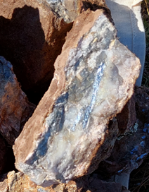
Photos of High-Grade Polymetallic Grab Samples Taken at Olympus

TORONTO, May 12, 2022 (GLOBE NEWSWIRE) — Collective Mining Ltd. (TSXV: CNL) (“Collective” or the “Company”) is pleased to announce high-grade gold and silver channel sample assay results from its grassroot generated Olympus target (“Olympus”) within the Guayabales project (“Guayabales”), Colombia. The Company presently has three diamond drill rigs operating at Guayabales with drills turning at the Olympus and Apollo targets as well as the newly discovered Trap target. At Olympus, the Company is focused on expanding upon the recently announced discovery holes of 302 metres @ 1.11 g/t gold equivalent and 216.7 metres @ 1.08 g/t gold equivalent (refer to press release dated March 15 and May 9, 2022, respectively).

Highlights (Table 1 and Figures 1 and 2)

  • Assay results of chip channel samples taken from veins located within historical, shallow underground workings from Olympus confirm the continuation of the high-grade carbonate base metal (“CBM”) sheeted vein system into the southwest portion of the target area with results as follows:

Table 1: Chip Channel Sample Assay Results from Olympus

Sample IDAu (g/t)Ag (g/t)
R5465220.97812
R5437134.73598
R545088.28409
R521673.83675
R541259.15365
CM394838.78450
R522633.9133
R546417.0268
R54539.06353
R52245.611
R54485.28329
R54565.1789
R54675.0262
R54134.97238
R54354.39108
R54344.20193
R54172.87161
R54522.7576
R54492.65102
R52192.5754
R54571.45347

*Channel chip samples reported above are over true horizontal sampling widths of between 0.1 and 1 metre. Sample grades are uncapped
**Channel samples are representative of 2dimensional space and as a result should not be relied upon as being representative of average grades anticipated in any future resource estimate or mining scenario.
***Assay results for base metals are still pending for all samples listed.

  • Multiple CBM veins were sampled, where possible at Olympus, over an area measuring 250 metres x 250 metres from limited and partial exposures of rock in old tunnels. The CBM veins are sulphide rich and associated with intense sericite-illite alteration superimposed on porphyry diorite and mineralized, hydrothermal breccia. Porphyry-related CBM veins can demonstrate robust continuity over significant vertical and lateral dimensions.
  • Drilling, underground sampling and surface mapping to date have expanded Olympus to a target area measuring more than 1,400 metres by 900 metres, which hosts over 50 artisanal mines with over 25 veins mapped from available exposures. The Company believes that the probability is high that additional veins will be discovered as exploration ramps up. The Olympus target is open to the east, west, northwest, south and at depth.
  • Olympus now includes two mineralized zones. Both zones contain multiple porphyry and overprinting CBM veins associated with intense pyrite-sericite-carbonate alteration and hosted in a porphyry diorite (Eastern zone) and within schist country rocks intruded by porphyritic diorite (Western zone).
  • The highest-grade samples collected to date at Olympus come from areas that have yet to be drill tested by the Company. Diamond drilling completed to date has only focused on a small northern portion of the Eastern and Western zones while recent surface and underground mapping has expanded the Western zone to the west and southwest.
  • The Company is planning to move two underground rigs in Q2 into the area covered by these high-grade channel sampling results.

“With the scale of veining and alteration at Olympus and mineralized systems that come to surface, the Company now believes that we have a discovered a vein and broad mineralized system,” commented Ari Sussman, Executive Chairman. “The more exploration we undertake, the more high-grade veins we find. We will remain aggressive with drilling at Olympus and look forward to commencing the first underground drill-hole into the high-grade vein portion of the system in June 2022.”

Figure 1: Plan View of the Guayabales Project and the Olympus South Target
https://www.globenewswire.com/NewsRoom/AttachmentNg/a3099c7e-51eb-4385-89ec-620f9c6a649d

Figure 2: Photos of High-Grade Polymetallic Grab Samples Taken at Olympus
https://www.globenewswire.com/NewsRoom/AttachmentNg/cbbce069-dbb1-4ad0-b430-f28519b8285c
Veins of massive sulfides with pyrite, sphalerite, galena and chalcopyrite.

Qualified Person (QP) and NI43-101 Disclosure

David J Reading is the designated Qualified Person for this news release within the meaning of National Instrument 43-101 (“NI 43-101”) and has reviewed and verified that the technical information contained herein is accurate and approves of the written disclosure of same. Mr. Reading has an MSc in Economic Geology and is a Fellow of the Institute of Materials, Minerals and Mining and of the Society of Economic Geology (SEG).

Technical Information

Rock samples have been prepared and analyzed at SGS laboratory facilities in Medellin, Colombia and Lima, Peru. Blanks, duplicates, and certified reference standards are inserted into the sample stream to monitor laboratory performance. Crush rejects and pulps are kept and stored in a secured storage facility for future assay verification. No capping has been applied to sample composites. The Company utilizes a rigorous, industry-standard QA/QC program.

About Collective Mining Ltd.

To view the Company’s most recent investor presentation, please visit www.collectivemining.com

Collective Mining is an exploration and development company focused on identifying and exploring prospective mineral projects in South America. Founded by the team that developed and sold Continental Gold Inc. to Zijin Mining for approximately $2 billion in enterprise value, the mission of the Company is to repeat its past success in Colombia by making a significant new mineral discovery and advancing the projection to production. Management, insiders and close family and friends own approximately 40% of the outstanding shares of the Company and as a result, are fully aligned with shareholders. Collective currently holds an option to earn up to a 100% interest in two projects located in Colombia. As a result of an aggressive exploration program at both the Guayabales and San Antonio projects a total of eleven major targets have been defined. The Company is fortuitous to have made significant grassroots discoveries on both projects with discovery holes of 302 metres 1.1 g/t AuEq and 104 metres @ 1.3 g/t AuEq at the Guayabales project and 710 metres @ 0.53 AuEq at the San Antonio project. (See press releases dated October 18th and 27th, 2021 and March 15, 2022, for AuEq calculations.)

Contact Information

Collective Mining Ltd.
Steve Gold, Vice President, Corporate Development and Investor Relations
Tel. (416) 648-4065

To schedule a one-on-one meeting with management please use the following link:
https://calendly.com/collectivemining/30min?month=2021-11

FORWARD-LOOKING STATEMENTS

This news release contains certain forward-looking statements, including, but not limited to, statements about the drill programs, including timing of results, and Collective’s future and intentions. Wherever possible, words such as “may”, “will”, “should”, “could”, “expect”, “plan”, “intend”, “anticipate”, “believe”, “estimate”, “predict” or “potential” or the negative or other variations of these words, or similar words or phrases, have been used to identify these forward-looking statements. These statements reflect management’s current beliefs and are based on information currently available to management as at the date hereof.

Forward-looking statements involve significant risk, uncertainties, and assumptions. Many factors could cause actual results, performance, or achievements to differ materially from the results discussed or implied in the forward-looking statements. These factors should be considered carefully, and readers should not place undue reliance on the forward-looking statements. Although the forward-looking statements contained in this news release are based upon what management believes to be reasonable assumptions, Collective cannot assure readers that actual results will be consistent with these forward-looking statements. These forward-looking statements are made as of the date of this news release, and Collective assumes no obligation to update or revise them to reflect new events or circumstances, except as required by law.

Neither the TSXV nor its Regulation Services Provider (as that term is defined in the policies of the TSXV) accepts responsibility for the adequacy or accuracy of this news release.

Categories
Uncategorized

Eloro Resources Intersects 160.00 g Ag eq/t (27.37g Ag/t, 0.62% Zn, 0.52% Pb and 0.11% Sn) over 251.87m and 133.45 g Ag eq/t (19.10g Ag/t, 0.20 g Au/t, 0.42% Zn, 0.64% Pb and 0.08% Sn) over 289.45m in the Santa Barbara Target area at the Iska Iska Silver-Tin Polymetallic Project, Potosi Department, Bolivia

Eloro Resources Ltd.Wed, May 25, 2022, 6:00 AMIn this article:

  • ELRRF0.00%

Eloro Resources Ltd.

Figure 1

Geological Plan Map showing Major Drilling areas.  Santa Barbara drilling is shown in more detail in Figure 2.
Geological Plan Map showing Major Drilling areas. Santa Barbara drilling is shown in more detail in Figure 2.

Figure 2

Geological Plan Map of the Santa Barbara Mineral Resource Target Area with Diamond Drill Holes

Figure 3

Northeast-Southwest Geological Section looking Northwest Showing Potential Higher Grade Feed Zone in the Santa Barbara Adit Area
  • These new drill results combined with previously released drill results for the underground drilling are defining a potential major feeder structure for the Ag-Sn polymetallic mineralization in the Santa Barbara Adit area.
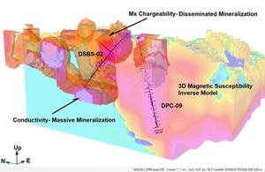
  • Bore Hole Induced Polarization (BHIP) surveys to a depth of almost 1,000m indicates that the conductivity increases with depth indicating that this potential feeder zone could be substantive.

TORONTO, May 25, 2022 (GLOBE NEWSWIRE) — Eloro Resources Ltd. (TSX-V: ELO; OTCQX: ELRRF; FSE: P2QM) (“Eloro”, or the “Company”) is pleased to announce assay results from an additional four (4) diamond drill holes from its on-going drilling program at the Iska Iska silver-tin polymetallic project in the Potosi Department, southern Bolivia. Holes DSBU-08, DSBU-07 and DSBU-04 are underground holes drilled from the Santa Barbara adit to test the southwestern and southern extension of the higher-grade mineralized zone. Surface drill hole DSB-26 tested the northwest extension of the Santa Barbara mineralized zone approximately 800m northwest of the Santa Barbara adit underground drill bay. Drilling is currently focussed primarily on the Santa Barbara Resource Definition Drilling Area with two surface drills and one underground drill. One surface drill is completing holes in the Porco area to test for a potential tin porphyry as suggested by the 3D inverse magnetic model (see Eloro press release dated March 1, 2022).

Overall, the Company has completed 56,863m in 92 drill holes to-date, including four holes in progress, as shown in Figures 1 and 2. Tables 1 and 2 list significant assay results for the drill holes in the major target areas. Prices used for calculating Ag equivalent grades are as outlined in Eloro’s February 1, 2022, press release. Table 3 summarizes drill holes with assays pending. Highlights are as follows:

Santa Barbara Mineral Resource Definition Target Area – Underground Drilling

Hole DSBS-07 was drilled underground at an azimuth of 2350 and dip of -500 to test the southwestern extension of the potential higher-grade area in the Santa Barbara Adit area. Hole DSBS-08 was drilled at the same inclination at an azimuth of 2000 while DSBU-04 was drilled due south at an angle of -200. All three holes intersected very long higher-grade intersections:

  • Hole DSBU-07 intersected 160.00 g Ag eq/t (27.37 g Ag/t, 0.62% Zn, 0.52% Pb and 0.11% Sn) over 251.87m from 0.00m to 251.87m, including a higher-grade section of:
    • 178.37 g Ag eq/t (28.84 g Ag/t, 0.69% Zn, 0.62% Pb, and 0.13% Sn) over 208.47m from 0.00m to 208.47m.
  • This hole had a second major intersection of 83.72 g Ag eq/t (6.67 g Ag/t and 0.11%Sn) over 208.93m from 272.87m to 481.8m. This included higher grade sections of:
    • 115.37g Ag eq/t (5.34 g Ag/t and 0.16%Sn) over 40.98m from 328.54 to 369.52m and
    • 224.01g Ag eq/t (1.50 g Ag/t and 0.35% Sn) over 21.58m from 438.11m to 459.69m.
  • Hole DSBU-08 intersected 133.45 g Ag eq/t (19.10 g Ag/t, 0.20 g Au/t, 0.42% Zn, 0.64% Pb, 0.06% Cu and 0.08% Sn) over 289.45m from 0.00m to 289.45m which included higher grade sections of:
    • 152.70 g Ag eq/t (44.65 g Ag/t, 0.08 g Au/t, 0.01% Zn, 0.58 %Pb, 0.20 %Cu and 0.09% Sn) over 22.56m from 0.00m to 22.56m,
    • 150.23 g Ag eq/t (47.17 g Ag/t, 0.03g Au/t, 0.01% Zn, 0.58 %Pb, 0.20% Cu and 0.09% Sn) over 10.82m from 57.10m to 67.92m,
    • 182.92 g Ag eq/t (40.31 g Ag/t, 0.13 g Au/t, 0.30% Zn, 0.88% Pb, 0.05% Cu and 0.14% Sn) over 27.09 m from 90.71m to 117.80m.
    • 222.51 g Ag eq/t (20.38 g Ag/t, 0.12 g Au/t, 1.09% Zn, 1.45% Pb, 0.05% Cu and 0.15% Sn) over 51.24 m from 163.14m to 214.38m, and
    • 254.55 g Ag eq/t (31.50 g Ag/t, 1.17 g Au/t, 0.73% Zn, 0.27% Pb, 0.08% Cu and 0.13% Sn) over 16.42 m from 244.48m to 260.90.
    • Overall, 65% of this 641.9m long hole had reportable intersections which collectively average 107.73 g Ag eq/t.
  • Hole DSBU-04 intersected 97.09 g Ag eq/t (30.11 g Ag/t, 0.41% Pb, 0.06% Cu and 0.07% Sn) over 154.62m from 0.00m to 154.62m which included higher grade sections of:
    • 126.66 g Ag eq/t (7.00 g Ag/t, 0.63 %Pb and 0.15% Sn) over 16.78m from 0.00m to 16.78m,
    • 174.32 g Ag eq/t (70.30 g Ag/t, 0.45 %Pb and 0.12% Sn) over 15.02m from 61.79m to 76.81m

Dr. Bill Pearson, P.Geo. Executive Vice President, Exploration commented: “As shown in Figure 3, a N-S cross section looking east, holes DSBU-07, DSBU-08 and DSBU-4 define a significant extension to the southwest and south of the major high grade mineralized area in the southern part of Santa Barbara. These results combined with previously released drill results for the underground drilling are defining a potential major feeder structure for the Ag-Sn polymetallic mineralization in the Santa Barbara area. Data from on-going borehole induced polarization surveys (BHIP) further reinforce the potential extent of this feeder zone.”

Dr. Chris Hale, P.Geo., Chief Geophysicist for Eloro commented: “Field personnel from MES Geophysics have advanced the borehole induced polarization (BHIP) survey technique to achieve excellent IP/Res data over 1000 m downhole, by reading while the drill is still on the hole. Preliminary analysis of Pole-dipole data at 25m intervals shows that the conductivity within about 10m of the axis of hole DHK-25 increases with depth between 500m and the end of the hole. Chargeability is highest near 525m but remains high (> 10 mV/V) over the entire interval to 975m. Cross hole chargeability and resistivity data have also been collected to a depth of 1000 m, between this hole and both DHK-24 and DSB-06. Data were also collected to 900m in DHK-24. Cross hole data from both DHK-24 and DHK-25 will be used for inverse modelling of the chargeable mineralization. Future BHIP surveys will use the “through-the-drill” technique to collect data, resolving fine detail in the geophysical models even at depths over a kilometer.”

Dr. Osvaldo Arce, P.Geo., General Manager of Eloro’s Bolivian subsidiary Minera Tupiza S.R.L. (“Minera Tupiza”), further commented: “Recent drill assay results from the Santa Barbara zone continue to expand a large and robust tin-silver polymetallic likely feeder zone located to the southeast of the Santa Barbara breccia pipe that is wide open at depth. Holes DSBU-4, DSBU-07 and DSBU-08 encountered numerous intervals of polymetallic oxide and sulphide mineralization that confirm multiple mineralizing events that occurred during the Miocene, which is an important feature of other large polymetallic deposits in the Eastern Andes of southern Bolivia.”

Northwest Extension, Santa Barbara Mineral Resource Definition Target Area

Hole DSBS-26 was collared 800m northwest of the Santa Barbara adit drill bay at an azimuth of 225 and dip of -400. This hole intersected 23 reportable mineralized intersections of which the most significant were as follows:

  • 76.10 g Ag eq/t (2.78 g Ag/t and 0.50% Cu) over 22.19m from 50.22 to 72.41m including a higher-grade section of:
    • 214.83 g Ag eq/t (10.90 g Ag/t and 1.48% Cu) over 4.44m from 50.22 to 54.66m
  • 735.49 g Ag eq/t (615.71 g Ag/t, 0.40 g Au/t, 0.20% Zn, 0.40% Pb and 0.17% Cu) over 10.46m from 134.74 to 145.20m
  • 93.02 g Ag eq/t (41.08 g Ag/t and 0.36% Zn) over 26.75m from 335.85 to 362.60m.
  • 264.05 g Ag eq/t (14.04 g Ag/t, 0.20% Zn, 0.38% Cu, and 0.31% Sn) over 20.06m from 407.51m to 427.57m
  • 70.56 g Ag eq/t (6.31 g Ag/t, 0.08 % Cu and 0.08 % Sn) over 67.50m from 591.71m to 659.21m including higher-grade sections of:
    • 93.46 g Ag eq/t (5.07 g Ag/t, 0.09% Cu and 0.11% Sn) over 18.06m from 594.72 to 612.78m and
    • 105.19 g Ag eq/t (13.00 g Ag/t, 0.11% Cu and 0.12% Sn) over 13.45m from 636.69 to 650.14m

Table 1: Significant Results, Underground Diamond Drilling, Santa Barbara Resource Definition Target Area as at May 25, 2022.

SANTA BARBARA RESOURCE DEFINITION TARGET ZONE
UNDERGROUND DRILL HOLES – SANTA BARBARA ADIT
Hole No.From (m)To (m)Length (m)AgAuZnPbCuSnBiCdAg eq
g/tg/t%%%%%%g/t
DSBU-080.00289.45289.4519.100.200.420.640.060.080.0070.003133.45
Incl.0.0022.5622.5644.650.080.010.580.200.090.0160.001152.70
Incl.57.1067.9210.8247.170.030.010.890.150.090.0020.001150.23
Incl.90.71117.8027.0940.310.130.300.880.050.140.0050.004182.92
Incl.163.14214.3851.2420.380.121.091.450.050.150.0070.006222.51
Incl.244.48260.9016.4231.501.170.730.270.080.130.0180.003254.55
 305.90308.882.9823.590.170.020.120.030.070.0120.00187.58
 322.42325.392.9732.450.380.030.070.030.040.0160.00199.55
 353.90410.3356.4348.530.080.100.030.050.050.0100.00196.73
Incl.353.90373.3019.40105.690.100.110.050.090.080.0150.001184.92
 417.77420.773.007.500.230.180.100.050.040.0050.00170.29
 428.29429.801.516.000.201.300.020.160.040.0040.001126.85
 434.15438.584.4312.140.140.330.010.060.040.0050.00171.88
 458.16472.9814.825.920.250.110.060.020.150.0050.001122.90
 488.01503.0315.024.900.800.050.010.030.090.0080.001129.61
 524.08527.093.014.010.200.060.010.310.510.0110.001363.98
 534.58552.6318.0510.270.390.030.010.050.070.0160.00197.09
 563.17578.2815.116.380.190.190.120.030.120.0080.001110.23
 585.79587.321.537.000.390.110.010.020.060.0410.00187.49
 596.56619.1022.546.940.300.050.050.000.090.0140.00188.81
 628.10632.634.537.560.480.310.020.020.050.0240.00196.64
 641.70643.211.511.000.010.350.010.010.060.0010.00154.10
 656.54659.442.905.970.050.600.010.020.020.0040.00152.15
 664.40669.054.657.330.060.570.030.020.010.0090.00150.98
 681.10682.651.554.000.070.040.030.010.220.0020.001146.14
 811.56813.061.504.000.030.510.040.040.040.0090.00160.25
 835.90842.006.1012.970.060.470.120.040.050.0030.00178.19
DSBU-070.00251.87251.8727.370.100.620.520.080.110.0080.007160.00
Incl.0.00208.47208.4728.840.080.690.620.090.130.0080.008178.37
 272.87481.80208.936.670.030.080.030.020.110.0120.00183.72
Incl.328.54369.5240.985.340.020.110.040.020.160.0180.002115.37
Incl.438.11459.6921.581.500.060.070.030.040.350.0280.001224.01
 535.76540.344.582.670.160.070.020.010.110.0700.00198.79
 556.84558.381.543.000.320.030.010.030.070.0160.00176.69
 565.93585.4819.552.580.140.100.080.030.070.0240.00170.81
Incl.565.93570.434.507.010.370.250.310.100.160.0710.001179.75
 589.98591.401.426.000.100.050.010.000.070.0010.00159.90
 594.40595.871.473.000.320.050.010.010.050.0040.00161.97
 609.38613.954.571.660.060.120.010.000.080.0040.00162.70
 636.47660.2723.801.560.140.030.010.050.050.0130.00152.97
 669.34670.921.586.000.850.020.040.070.080.1310.001157.15
 685.90690.534.6313.000.050.410.160.010.060.0010.00175.96
 693.73695.241.514.000.031.050.010.000.010.0010.00661.12
 740.65742.181.5313.000.210.010.010.120.110.0570.001121.41
DSBU-040.00154.62154.6230.110.030.010.410.040.070.0040.00597.09
Incl.0.0016.7816.787.000.080.010.630.020.150.0040.005126.66
Incl.61.7976.8115.0270.300.020.020.450.090.120.0050.005174.32
 256.93272.0215.0914.060.030.970.410.010.040.0010.007100.31
 276.62278.101.487.000.010.020.490.010.070.0010.00566.06
 288.64290.141.5040.000.046.152.720.020.260.0080.020572.30
 360.98368.437.451.000.010.910.130.020.040.0010.00471.39
 377.41385.047.632.000.010.930.210.010.030.0020.00274.41
 414.12415.631.511.000.010.850.590.000.000.0010.04464.52
 427.17445.1517.9816.830.022.790.470.010.040.0020.019186.76
 496.44499.262.822.040.011.440.110.000.020.0010.00683.24
 504.88506.431.551.000.011.190.030.010.010.0010.00263.57
 513.00514.481.488.000.010.751.810.000.040.0010.002123.93
 524.85532.247.396.930.011.440.340.000.070.0020.004127.29
 551.78553.301.521.000.071.190.070.000.070.0030.003106.03

Note: True width of the mineralization is not known at the present time, but based on the current understanding of the relationship between drill orientation/inclination and the mineralization within the breccia pipes and the host rocks such as sandstones and dacites, it is estimated that true width ranges between 70% and 90% of the down hole interval length but this will be confirmed by further drilling and geological modelling.

Chemical symbols: Ag= silver, Au = gold, Zn = zinc, Pb = lead, Cu = copper, Sn = tin, Bi = bismuth, Cd = cadmium and g Ag eq/t = grams silver equivalent per tonne. Quantities are given in percent (%) for Zn, Pb Cu, Sn, Bi and Cd and in grams per tonne (g/t) for Ag, Au and Ag eq.

Metal prices and conversion factors used for calculation of g Ag eq/t (grams Ag per grams x metal ratio) are as follows (Prices updated as of February 1, 2022, to more accurately reflect current metal prices):

ElementPrice $US
(per kg)
Ratio to Ag
Ag$722.561.0000
Sn$42.560.0589
Zn$3.300.0046
Pb$2.330.0032
Au$57,604.0079.7221
Cu$9.680.0134
Bi$12.760.0177
Cd$5.500.0076


In calculating the intersections reported in this press release a sample cutoff of 30 g Ag eq/t was used with generally a maximum dilution of 3 continuous samples below cutoff included within a mineralized section unless more dilution is justified geologically.

The equivalent grade calculations are based on the stated metal prices and are provided for comparative purposes only, due to the polymetallic nature of the deposit. Metallurgical tests are in progress by Blue Coast Ltd. to establish levels of recovery for each element reported but currently the potential recovery for each element has not yet been established. While there is no assurance that all or any of the reported concentrations of metals will be recoverable, Bolivia has a long history of successfully mining and processing similar polymetallic deposits which is well documented in the landmark volume “Yacimientos Metaliferos de Bolivia” by Dr. Osvaldo R. Arce Burgoa, P.Geo.

Table 2: Significant Results, Surface Diamond Drilling, Santa Barbara Resource Definition Target Area – Northwest Extension as at May 25, 2022.

SANTA BARBARA RESOURCE DEFINITION TARGET ZONE
SURFACE DIAMOND DRILLING – NORTHWEST EXTENSION
Hole No.From (m)To (m)Length (m)AgAuZnPbCuSnBiCdAg eq
g/tg/t%%%%%%g/t
DSB-2650.2272.4122.192.780.010.010.030.500.010.0010.00176.10
Incl.50.2254.664.4410.900.020.000.051.480.000.0010.001214.83
 104.71121.2716.5611.320.120.350.080.010.020.0090.00155.20
Incl.104.71106.221.5184.001.250.100.140.010.040.0950.001231.91
 134.74145.2010.46615.710.400.200.410.170.070.0090.001735.49
 194.50195.991.4943.000.210.080.150.070.080.0130.002126.20
 203.69205.191.507.000.400.370.140.010.080.0130.035113.80
 241.27262.3221.050.920.010.770.270.010.010.0010.00356.00
 295.20298.203.0014.000.160.400.010.050.030.0040.00171.28
 304.22313.208.9831.520.100.110.010.090.080.0070.001102.83
 335.85362.6026.7541.080.080.360.020.060.030.0150.00293.02
 357.97362.604.63195.650.050.330.010.080.040.0220.001255.05
 407.51427.5720.0614.040.050.200.020.380.310.0180.001264.05
 446.96449.922.965.410.060.140.010.150.120.0130.001108.61
 476.98478.451.476.000.130.140.000.090.060.0120.00171.41
 487.42488.931.516.000.070.010.010.100.090.0250.00184.30
 530.79532.351.563.000.030.010.000.100.070.0060.00163.06
 538.29572.3734.082.210.120.250.000.090.020.0030.00149.76
 591.71659.2167.506.310.060.040.000.080.080.0130.00170.56
Incl.594.72612.7818.065.070.070.080.000.090.110.0210.00193.46
Incl.636.69650.1413.4513.000.030.020.000.110.120.0110.001105.19
 665.21666.721.519.000.120.040.010.210.180.1070.001170.93
 693.35696.403.0528.950.270.050.010.630.550.0670.001474.73
 725.89727.531.640.501.200.460.000.010.000.0030.001120.48
 766.09770.694.608.080.130.570.010.240.090.1720.001160.65
 789.80791.301.507.000.320.720.040.410.010.7220.001256.32
 806.33807.801.476.000.140.390.050.270.000.3850.001142.79

See Note Table 1.

Figure 1 – Geological Plan Map showing Major Drilling areas. Santa Barbara drilling is shown in more detail in Figure 2.
https://www.globenewswire.com/NewsRoom/AttachmentNg/d72bf44c-804d-43c5-8a0d-6d488775ab10 

Figure 2: Geological Plan Map of the Santa Barbara Mineral Resource Target Area with Diamond Drill Holes
https://www.globenewswire.com/NewsRoom/AttachmentNg/1d597c7a-be89-4fef-b7dc-ae0c15c8c1eb

Figure 3: Northeast-Southwest Geological Section looking Northwest Showing Potential Higher Grade Feed Zone in the Santa Barbara Adit Area
https://www.globenewswire.com/NewsRoom/AttachmentNg/310b1001-0864-4f3c-a249-7b31cb081f2e

Table 3: Summary of Diamond Drill Holes Completed with Assays Pending and Drill Holes in Progress at Iska Iska from May 25, 2022 press release.

SUMMARY DIAMOND DRILLING ISKA ISKA
Hole No.TypeCollar
Easting
Collar
Northing
ElevAzimuthAngleHole length
(m)
Surface Drilling Santa Barbara Breccia
DHK-24S205529.47656222.54153.4225°-60°812.5
DHK-25S205526.97656384.74178.1225°-55°803.2
      Subtotal1615.7
Surface Drilling Northwest Extension Santa Barbara
DSB-16S204973.97657053.14147.1225°-65°862.0
DSB-17S205136.37656770.84168.1225°-40°841.0
DSB-18S205209.37656683.34172.5225°-40°890.4
DSB-19S205209.97656684.04172.5225°-65°803.3
DSB-23S205343.37656534.44176.1225°-40°863.2
DSB-27S205044.57656982.64150.0225°-65°800.4
      Subtotal5060.3
DSB-28S205512.07656112.04162.0225°-60°In progress
DSB-29S205511.07655966.94134.0225°-60°In progress
Underground Drilling Santa Barbara Adit
DSBU-09UG205284.57656080.04167.190°-60°904.0
      Subtotal904.0
DSBU-10UG205284.57656080.04167.140°-60°In Progress
Surface Drilling South Extension Santa Barbara
DSBS-02S205300.07655563.04195.0-45°1023.4
      Subtotal1,724.2
Porco Target Area – Surface Drill Program Testing Magnetic Inverse Model
DPC-07S205090.17655340.94310.0235°-60°791.4
DPC-08S205585.07655423.64089.0235°-65°800.4
DPC-09S205456.77655516.64125.0180°-75°1124.4
DPC-10S205396.57655701.24148.0225°-60°1088.4
DPC-11S205456.77655516.64125.0235°-70°1065.0
DPC-12S205650.07655200.04100.0235°-70°941.4
      Subtotal5,811.0
DM2-01S2059447654211367430°-60°In Progress
      Total15,115.2

S = Surface UG=Underground; collar coordinates in metres; azimuth and dip in degrees. Total drilling completed since the start of the program on September 13, 2020 to December 17, 2021 is 40,468 m in 73 holes (26 underground holes and 47 surface holes). From re-start of drilling on January 17, 2022, an additional 16,395m has been completed bringing the overall total to 56,863m in 92 drill holes (30 underground drill holes and 62 surface drill holes) including 4 holes in progress.


Qualified Person

Dr. Osvaldo Arce, P. Geo., General Manager of Minera Tupiza, and a Qualified Person in the context of NI 43-101, has reviewed and approved the technical content of this news release.  Dr. Bill Pearson, P.Geo., Executive Vice President Exploration Eloro, and who has more than 45 years of worldwide mining exploration experience including extensive work in South America, manages the overall technical program working closely with Dr. Osvaldo Arce, P.Geo., Manager of Minera Tupiza. Dr. Quinton Hennigh, P.Geo., Senior Technical Advisor to Eloro and Independent Technical Advisor, Mr. Charley Murahwi P. Geo., FAusIMM of Micon International Limited are regularly consulted on technical aspects of the project.

The magnetic survey was carried out by MES Geophysics using a GEM Systems GSM-19W Overhauser magnetometer. Dr. Chris Hale, P.Geo. and Mr. John Gilliatt, P.Geo. of Intelligent Exploration provided the survey design, preparation of the maps and interpretation from data processed and quality reviewed by Rob McKeown, P. Geo. of MES Geophysics. Messrs. Hale, Gilliatt and McKeown are Qualified Persons as defined under NI 43-101. Mr. Joe Mihelcic, P.Eng., P.Geo., of Clearview Geophysics, a QP under NI 43-101, completed the 3D magnetic inversion model in consultation with Dr. Hale and Mr. Gilliatt. The Borehole IP surveys are being carried out by MES Geophysics under the supervision of Dr. Hale and Mr. Gilliatt.

Eloro is utilizing both ALS and AHK for drill core analysis, both of whom are major international accredited laboratories. Drill samples sent to ALS are prepared in both ALS Bolivia Ltda’s preparation facility in Oruro, Bolivia and the preparation facility operated by AHK in Tupiza with pulps sent to the main ALS Global laboratory in Lima for analysis. More recently Eloro has had ALS send pulps to their laboratory at Galway in Ireland. Eloro employs an industry standard QA/QC program with standards, blanks and duplicates inserted into each batch of samples analyzed with selected check samples sent to a separate accredited laboratory.

Drill core samples sent to AHK Laboratories are prepared in a preparation facility installed and managed by AHK in Tupiza with pulps sent to the AHK laboratory in Lima, Peru. Au and Sn analysis on these samples is done by ALS Bolivia Ltda in Lima. Check samples between ALS and AHK are regularly done as a QA/QC check. AHK is following the same analytical protocols used as with ALS and with the same QA/QC protocols. Turnaround time continues to improve, as laboratories return to more normal staffing levels.

About Iska Iska

Iska Iska silver-tin polymetallic project is a road accessible, royalty-free property, wholly controlled by the Title Holder, Empresa Minera Villegas S.R.L. and is located 48 km north of Tupiza city, in the Sud Chichas Province of the Department of Potosi in southern Bolivia. Eloro has an option to earn a 99% interest in Iska Iska.

Iska Iska is a major silver-tin polymetallic porphyry-epithermal complex associated with a Miocene possibly collapsed/resurgent caldera, emplaced on Ordovician age rocks with major breccia pipes, dacitic domes and hydrothermal breccias. The caldera is 1.6km by 1.8km in dimension with a vertical extent of at least 1km. Mineralization age is similar to Cerro Rico de Potosí and other major deposits such as San Vicente, Chorolque, Tasna and Tatasi located in the same geological trend.

Eloro began underground diamond drilling from the Huayra Kasa underground workings at Iska Iska on September 13, 2020. On November 18, 2020, Eloro announced the discovery of a significant breccia pipe with extensive silver polymetallic mineralization just east of the Huayra Kasa underground workings and a high-grade gold-bismuth zone in the underground workings. On November 24, 2020, Eloro announced the discovery of the SBBP approximately 150m southwest of the Huayra Kasa underground workings.

Subsequently, on January 26, 2021, Eloro announced significant results from the first drilling at the SBBP including the discovery hole DHK-15 which returned 129.60 g Ag eq/t over 257.5m (29.53g Ag/t, 0.078g Au/t, 1.45%Zn, 0.59%Pb, 0.080%Cu, 0.056%Sn, 0.0022%In and 0.0064% Bi from 0.0m to 257.5m. Subsequent drilling has confirmed significant values of Ag-Sn polymetallic mineralization in the SBBP and the adjacent CBP. A substantive mineralized envelope which is open along strike and down-dip extends around both major breccia pipes. Continuous channel sampling of the Santa Barbara Adit located to the east of SBBP returned 442 g Ag eq/t (164.96 g Ag/t, 0.46%Sn, 3.46% Pb and 0.14% Cu) over 166m including 1,092 g Ag eq/t (446 g Ag/t, 9.03% Pb and 1.16% Sn) over 56.19m. The west end of the adit intersects the end of the SBBP.

Since the initial discovery hole, Eloro has released a number of significant drill results in the SBBP and the surrounding mineralized envelope which along with geophysical data has defined a target zone 1400m along strike, 500m wide and that extends to a depth of 600m. This zone is open along strike to the northwest and southeast as well as to the southwest. The Company’s nearer term objective is to outline a maiden NI 43-101 compliant mineral resource within this large target area. This work is advancing well with the mineral resource targeted to be completed in Q3 2022. Exploration drilling is also planned on other major targets in the Iska Iska Caldera Complex, including the Porco and Mina 2 areas.

About Eloro Resources Ltd.

Eloro is an exploration and mine development company with a portfolio of gold and base-metal properties in Bolivia, Peru and Quebec. Eloro has an option to acquire a 99% interest in the highly prospective Iska Iska Property, which can be classified as a polymetallic epithermal-porphyry complex, a significant mineral deposit type in the Potosi Department, in southern Bolivia. Eloro commissioned a NI 43-101 Technical Report on Iska Iska, which was completed by Micon International Limited and is available on Eloro’s website and under its filings on SEDAR. Iska Iska is a road-accessible, royalty-free property. Eloro also owns an 82% interest in the La Victoria Gold/Silver Project, located in the North-Central Mineral Belt of Peru some 50 km south of Barrick’s Lagunas Norte Gold Mine and Pan American Silver’s La Arena Gold Mine. La Victoria consists of eight mining concessions and eight mining claims encompassing approximately 89 square kilometres. La Victoria has good infrastructure with access to road, water and electricity and is located at an altitude that ranges from 3,150 m to 4,400 m above sea level.

For further information please contact either Thomas G. Larsen, Chairman and CEO or Jorge Estepa, Vice-President at (416) 868-9168.

Information in this news release may contain forward-looking information. Statements containing forward-looking information express, as at the date of this news release, the Company’s plans, estimates, forecasts, projections, expectations, or beliefs as to future events or results and are believed to be reasonable based on information currently available to the Company. There can be no assurance that forward-looking statements will prove to be accurate. Actual results and future events could differ materially from those anticipated in such statements. Readers should not place undue reliance on forward-looking information.

Neither the TSXV nor its Regulation Services Provider (as that term is defined in the policies of the TSXV) accepts responsibility for the adequacy or accuracy of this release.

Categories
Gold Shore Resources Junior Mining Precious Metals Uncategorized

Goldshore Resources Announces Innovative Technology Application for Moss Lake Project Exploration and Closing of Non-Brokered Financing

Vancouver, British Columbia–(Newsfile Corp. – May 18, 2022) – Goldshore Resources Inc. (TSXV: GSHR) (OTCQB: GSHRF) (FSE: 8X00) (“Goldshore” or the “Company“), is pleased to announce that it is working with Dr. Russell Birrell of Globex on implementing his innovative ionic leach soil sampling technique that will enable the Company to detect bedrock anomalies beneath muskeg swamp and glacial till. Initial sampling will be conducted across known mineralization at the QES Zone to calibrate the geochemical response and enable a more accurate assessment of results in new areas.

Peter Flindell, Vice President Exploration, comments“I have worked with Dr. Birrell and the ionic leach technique in Scotland where we successfully identified several mineralized targets. This technique is well suited to the type of cover at Moss Lake and I look forward to reviewing the first results over the QES Zone. The ionic leach program will continue throughout the 2022 summer field season and focus on the targets developed from last year’s VTEM/magnetics survey. This will help us to rank and rate all targets, and to prioritize the scout drilling program, outside the historical Moss Lake deposit.”

Dr. Birrell was part of the team that developed the Mobile Metal Ion (MMI) sampling technique at CSIRO. The MMI technique has been widely used in exploration programs for the past three decades. His work on ionic leach marks an order of magnitude increase in sensitivity that has mapped several concealed mineralized targets in similar terranes.

Closing of Non-Brokered Financing

The Company is also pleased to announce that it has closed a non-brokered private placement of 1,000,000 units (each, a “Unit“) at a price of $0.50 per Unit for gross proceeds of $500,000 (the “Financing“). Each Unit issued in connection with the Financing is comprised of one common share of the Company (each, a “Common Share“) and one-half common share purchase warrant (each whole warrant, a “Warrant“). Each Warrant shall entitle the holder thereof to acquire one Common Share at an exercise price of $0.75, for a period of 24 months following the date hereof, subject to acceleration if the Common Shares trade above $1.10 on the TSX Venture Exchange (the “Exchange“) for twenty (20) consecutive days.

The Company intends to use the proceeds raised from the Financing for future exploration work on its Moss Lake gold deposit in Northwest Ontario, Canada and for general working capital purposes.

The securities issued pursuant to the Financing will be subject to a four-month and one day hold period under applicable securities laws in Canada. Closing of the Financing is subject to final approval by the Exchange.

About Goldshore

Goldshore is an emerging junior gold development company, and owns the Moss Lake Gold Project located in Ontario. Wesdome Gold Mines Ltd. is currently a strategic shareholder of Goldshore with an approximate 22% equity position in the Company. Well-financed and supported by an industry-leading management group, board of directors and advisory board, Goldshore is positioned to advance the Moss Lake Gold Project through the next stages of exploration and development.

About the Moss Lake Gold Project

The Moss Lake Gold Project is located approximately 100 km west of the city of Thunder Bay, Ontario. It is accessed via Highway 11 which passes within 1 km of the property boundary to the north. The Moss Lake Gold Project covers 14,292 hectares and consists of 282 unpatented and patented mining claims.

Moss Lake hosts a number of gold and base metal rich deposits including the Moss Lake Deposit, the East Coldstream Deposit (Table 1), the historically producing North Coldstream Mine (Table 2), and the Hamlin Zone, all of which occur over a mineralized trend exceeding 20 km in length. A historical preliminary economic assessment was completed on Moss Lake in 2013 and published by Moss Lake Gold1. A historical mineral resource estimate was completed on the East Coldstream Deposit in 2011 by Foundation Resources Inc2,3. In addition to these zones, the Moss Lake Gold Project also hosts a number of under-explored mineral occurrences which are reported to exist both at surface and in historically drilled holes. The Moss Lake Deposit is a shear-hosted disseminated-style gold deposit which outcrops at surface. It has been drilled over a 2.5 km length and to depths of 300 m with 376 holes completed between 1983 and 2017. The last drilling program conducted in 2016 and 2017 by Wesdome Gold Mines Ltd. (“Wesdome“), which consisted of widely spaced holes along the strike extension of the deposit was successful in expanding the mineralized footprint and hydrothermal system 1.6 km to the northeast. Additionally, the deposit remains largely open to depth. In 2017, Wesdome completed an induced polarization survey which traced the potential extensions of pyrite mineralization associated with the Moss Lake Deposit over a total strike length of 8 km and spanning the entire extent of the survey grids.

The East Coldstream Deposit is a shear-hosted disseminated-style gold deposit which locally outcrops at surface. It has been drilled over a 1.3 km length and to depths of 200 m with 138 holes completed between 1988 and 2017. The deposit remains largely open at depth and may have the potential for expansion along strike. Historic drill hole highlights from the East Coldstream Deposit include 4.86 g/t Au over 27.3 m in C-10-15.

The historically producing North Coldstream Mine is reported to have produced significant amounts of copper, gold and silver4 from mineralization with potential iron-oxide-copper-gold deposit style affinity. The exploration potential immediately surrounding the historic mining area is not currently well understood and historic data compilation is required.

The Hamlin Zone is a significant occurrence of copper and gold mineralization, and also of potential iron-oxide-copper-gold deposit style affinity. Between 2008 and 2011, Glencore tested Hamlin with 24 drill holes which successfully outlined a broad and intermittently mineralized zone over a strike length of 900 m. Historic drill hole highlights from the Hamlin Zone include 0.9 g/t Au and 0.35% Cu over 150.7 m in HAM-11-75.

The Moss Lake, East Coldstream and North Coldstream deposits sit on a mineral trend marked by a regionally significant deformation zone locally referred to as the Wawiag Fault Zone in the area of the Moss Lake Deposit. This deformation zone occurs over a length of approximately 20 km on the Moss Lake Gold Project and there is an area spanning approximately 7 km between the Moss Lake and East Coldstream deposits that is significantly underexplored.

Table 1: Historical Mineral Resources1,2,3

INDICATEDINFERRED
DepositTonnesAu g/tAu ozTonnesAu g/tAu oz
Moss Lake Deposit1 (2013 resource estimate)
Open Pit Potential39,795,0001.11,377,30048,904,0001.01,616,300
Underground Potential1,461,1002.9135,400
Moss Lake Total39,795,0001.11,377,30050,364,0001.11,751,600
East Coldstream Deposit2 (2011 resource estimate)
East Coldstream Total3,516,7000.8596,40030,533,0000.78763,276
Combined Total43,311,7001.081,473,70080,897,0000.982,514,876

Notes:

(1) Source: Poirier, S., Patrick, G.A., Richard, P.L., and Palich, J., 2013. Technical Report and Preliminary Economic Assessment for the Moss Lake Project, 43-101 technical report prepared for Moss Lake Gold Mines Ltd. Moss Lake Deposit resource estimate is based on 0.5 g/t Au cut-off grade for open pit and 2.0 g/t Au cut-off grade for underground resources.

(2) Source: McCracken, T., 2011. Technical Report and Resource Estimate on the Osmani Gold Deposit, Coldstream Property, Northwestern Ontario, 43-101 technical report prepared for Foundation Resources Inc. and Alto Ventures Ltd. East Coldstream Deposit resource estimate is based on a 0.4 g/t Au cut-off grade.

(3) The reader is cautioned that the above referenced “historical mineral resource” estimates are considered historical in nature and as such is based on prior data and reports prepared by previous property owners. A qualified person has not done sufficient work to classify the historical estimates as current resources and Goldshore is not treating the historical estimates as current resources. Significant data compilation, re-drilling, re-sampling and data verification may be required by a qualified person before the historical estimate on the Moss Lake Gold Project can be classified as a current resource. There can be no assurance that any of the historical mineral resources, in whole or in part, will ever become economically viable. In addition, mineral resources are not mineral reserves and do not have demonstrated economic viability. Even if classified as a current resource, there is no certainty as to whether further exploration will result in any inferred mineral resources being upgraded to an indicated or measured mineral resource category.

Table 2: Reported Historical Production from the North Coldstream Deposit4

DepositTonnesCu %Au g/tAgCu lbsAu ozAg oz
Historical Production2,700,00001.890.565.59102,000,00044,000440,000

Note:

(4) Source: Schlanka, R., 1969. Copper, Nickel, Lead and Zinc Deposits of Ontario, Mineral Resources Circular No. 12, Ontario Geological Survey, pp. 314-316.

Peter Flindell, MAusIMM, MAIG, Vice President – Exploration of the Company, a qualified person under NI 43-101 has approved the scientific and technical information contained in this news release.

Neither the TSXV nor its Regulation Services Provider (as that term is defined in the policies of the TSXV) accepts responsibility for the adequacy or accuracy of this release.

For More Information – Please Contact:

Brett A. Richards
President, Chief Executive Officer and Director
Goldshore Resources Inc.

P. +1 604 288 4416 M. +1 905 449 1500
E. brichards@goldshoreresources.com
W. www.goldshoreresources.com

Facebook: GoldShoreRes | Twitter: GoldShoreRes | LinkedIn: goldshoreres

Cautionary Note Regarding Forward-Looking Statements

This news release contains statements that constitute “forward-looking statements.” Such forward-looking statements involve known and unknown risks, uncertainties and other factors that may cause the Company’s actual results, performance or achievements, or developments to differ materially from the anticipated results, performance or achievements expressed or implied by such forward-looking statements. Forward-looking statements are statements that are not historical facts and are generally, but not always, identified by the words “expects,” “plans,” “anticipates,” “believes,” “intends,” “estimates,” “projects,” “potential” and similar expressions, or that events or conditions “will,” “would,” “may,” “could” or “should” occur.

Forward-looking statements in this news release include, among others, statements relating to expectations regarding the exploration and development of the Moss Lake Gold Project, the use of proceeds from the Financing, and other statements that are not historical facts. By their nature, forward-looking statements involve known and unknown risks, uncertainties and other factors which may cause our actual results, performance or achievements, or other future events, to be materially different from any future results, performance or achievements expressed or implied by such forward-looking statements. Such factors and risks include, among others: the Company may require additional financing from time to time in order to continue its operations which may not be available when needed or on acceptable terms and conditions acceptable; compliance with extensive government regulation; domestic and foreign laws and regulations could adversely affect the Company’s business and results of operations; the stock markets have experienced volatility that often has been unrelated to the performance of companies and these fluctuations may adversely affect the price of the Company’s securities, regardless of its operating performance; and the impact of COVID-19.

The forward-looking information contained in this news release represents the expectations of the Company as of the date of this news release and, accordingly, is subject to change after such date. Readers should not place undue importance on forward-looking information and should not rely upon this information as of any other date. The Company undertakes no obligation to update these forward-looking statements in the event that management’s beliefs, estimates or opinions, or other factors, should change.

This news release does not constitute an offer to sell, or a solicitation of an offer to buy, any securities in the United States. The securities have not been and will not be registered under the United States Securities Act of 1933, as amended (the “U.S. Securities Act”) or any state securities laws and may not be offered or sold within the United States or to U.S. Persons unless registered under the U.S. Securities Act and applicable state securities laws or an exemption from such registration is available.

Categories
Uncategorized

Mountain Province Diamonds Announces Successful Exploration Update for Kennady North

TORONTO and NEW YORK, May 17, 2022 /CNW/ – Mountain Province Diamonds Inc. (“Mountain Province”, the “Company”) (TSX: MPVD) (OTC: MPVD) today announces interim exploration results for its 100%-held Kennady North Project. The Kennady North Project consists of over 107,000 hectares of claims and leases that completely surround the Gahcho Kué Diamond Mine. The 2022 exploration program is focussed on finding new kimberlites based on a detailed analysis of historical technical information including ground and airborne geophysics, kimberlite indicator minerals, and geological mapping. Approximately 3,000 of the ongoing 6,000 meter winter drill program have been completed.

Exploration Highlights for the Winter Program

  • Kimberlite intersected in 16 of 20 drill holes
  • 3 of 4 target areas have returned Kimberlite Intersections
  • Winter geophysics completed

Mark Wall, the Company’s President and Chief Executive Officer, commented:

We began 2022 with a plan to launch an aggressive winter exploration campaign over Kennady North, and we have achieved that plan. We have discovered kimberlite in three of four targets tested to date, and completed all of our scheduled airborne and ground geophysics. In the final weeks of our winter program, we will continue to drill-test as many priority anomalies as feasible with the intent to discover more kimberlite and add value to the Kennady North Project. As a pure Canadian diamond producer and explorer, we see this as an important time to aggressively explore for new Canadian diamond production”

Of the sixteen targets identified four have been tested by drilling so far. Drilling will continue through the rest of the winter 2022 program which is expected to culminate at the end of May. Summer exploration will start in Q3 with emphasis on follow-up sampling of indicator mineral results generated from the 2021 till sampling program, which are expected to be complete by the end of Q3. A review of all winter 2022 ground geophysical data continues through Q2 with the intent to drill areas of interest (“AOI”) with land-based anomalies in the summer program.

To date, 2,935 meters from 20 drillholes have been collected from the North Anomaly, South Anomaly, KS Anomaly and G6 Anomaly. These anomalies were defined using ARRT (a high-resolution ground resistivity system developed by Aurora Geoscience Ltd., Yellowknife), and by ground gravity. Both systems recognize the physical contrast between competent country rock and country rock adjacent to kimberlite that is broken and altered from emplacement of the kimberlite. Locations for these anomalies relative to the Kelvin and Faraday kimberlites are shown in the first set of images.

Locations for the anomalies relative to the Kelvin and Faraday kimberlites (CNW Group/Mountain Province Diamonds Inc.)

Seven drillholes completed at the North Anomaly have identified depth-extensive zones of highly altered country rock intermixed with intersects of hypabyssal kimberlite (‘HK’) ranging from 0.03 to 6.93 meters in thickness (average thickness 1.54m). Suspected volcaniclastic kimberlite (‘VK’) has been intersected in three drillholes and ranges from 0.16 to 2.13 meters in thickness (average 0.95m), with 3D modeling of the drilling indicating lateral continuity for the VK. For Kelvin and Faraday kimberlites at Kennady North, VK comprises the greatest volume and its presence in the exploration drilling is considered a good indication for volume potential at the North Anomaly.

At the South Anomaly all five drillholes have HK present with thicknesses ranging from 0.68 to 6.96 meters (average 3.23m). Country rock breccia consisting of highly comminuted gneiss mixed with kimberlite has also been observed, and is indicative of volume potential for the South Anomaly.

Four of six drillholes at the KS anomaly intersected HK kimberlite ranging from 0.22 to 1.49 meters in thickness. The present interpretation for the KS anomaly is that the system is lacking the kimberlitic fluids necessary to break up country rock and provide volume for VK to develop. A table of drill results for the North, South and KS Anomaly is provided below.

Drill HoleAzimuth2Inclination2Kimberlite Intersect1,2 (m)End of
Hole2(m)
FromToLength1
North Anomaly
KDI-22-008128.5-71.275.8681.485.62121.0
KDI-22-010135.8-49.483.2786.593.32127.4
KDI-22-01247.9-46.1107.05113.986.93150.0
KDI-22-01349.4-60.781.5681.750.19121.0
plus82.6182.980.37
plus83.6883.880.20
plus85.0785.450.38
plus86.1086.130.03
plus86.3086.520.22
plus87.7288.751.03
KDI-22-01545.0-52.576.7676.900.14
plus77.6678.600.94
plus80.7381.100.37
plus83.9087.003.10
KDI-22-01645.0-62.069.5072.402.90
plus73.1573.700.55
KDI-22-019223.7-52.476.6076.760.16
plus77.1378.831.70
South Anomaly
KDI-22-001307.4-46.1109.00113.134.13163.0
KDI-22-002294.3-65.084.1990.065.87114.7
KDI-22-00348.6-45.5115.02121.986.96142.0
KDI-22-00446.2-69.498.5799.250.68139.0
KDI-22-007182.0-89.066.0368.422.39121.0
plus79.9781.451.48
plus85.4886.571.09
KS Anomaly
KDI-22-00535.1-46.1217.08218.571.49163.0
KDI-22-00631.3-54.7114.7
KDI-22-00926.0-67.763.5163.760.2593.2
KDI-22-01124.9-52.5152.0
KDI-22-01827.0-50.035.5035.650.15160.0
plus37.0037.250.25
plus40.2040.500.30
plus46.4647.711.25
plus65.1466.000.86
1Intersects are not true thicknesses. 2Initial measurements from field logs may change with further drillhole surveying and logging.

The target AOI were selected from recently-compiled studies of glacial geology and kimberlite indicator mineral (KIM) dispersions over the project area. Additional target AOI were selected after a review of historical geophysical data for Kennady North. These datasets were reviewed during several in-house workshops held in late 2021 and early 2022, with final ranking of sixteen AOI completed in a joint workshop held with De Beers in February 2022. The sixteen AOI were scheduled for ARRT and ground gravity surveys during the winter program, with a total of 188.8 line-km of ARRT and 3,139 gravity stations completed over the targets. A map image of the AOI that received ground geophysics for drill-targeting is shown in the third image.

A map image of the AOI that received ground geophysics for drill-targeting (CNW Group/Mountain Province Diamonds Inc.)

Drilling has started at the G6 anomaly, situated on the winter spur road to Gahcho Kué Mine. The G6 anomaly is the result of a 1997 DIGHEM airborne survey that delineated the Kelvin, Faraday and Gahcho Kué kimberlites. Recent drilling over follow-up coincident ARRT and ground gravity anomalies encountered no kimberlite. Assessment of the drill data is underway.

In addition to the ground geophysical surveys, a small airborne magnetic/electromagnetic survey was conducted over an unsurveyed area located one kilometer southeast of Gahcho Kué. A total of 1,291 line-km of data were collected over the area.

In 2021 over 600 till samples were collected over the project area, including the recently staked Kennady East claims. Preliminary results for 47 samples confirm the presence of pyrope, chromite and picroilmenite in esker samples from the southern portion of the Kennady East claims. The distribution of 2021 till samples and outline of the 2022 airborne geophysics program are shown in the fourth and final image.

The distribution of 2021 till samples and outline of the 2022 airborne geophysics program. (CNW Group/Mountain Province Diamonds Inc.)

About the Company

Mountain Province Diamonds is a 49% participant with De Beers Canada in the Gahcho Kué diamond mine located in Canada’s Northwest Territories. The Gahcho Kué Joint Venture property consists of several kimberlites that are actively being mined, developed, and explored for future development. The Company also controls 106,202 hectares of highly prospective mineral claims and leases that surround the Gahcho Kué Joint Venture property that include an indicated mineral resource for the Kelvin kimberlite and inferred mineral resources for the Faraday kimberlites.

For further information on Mountain Province Diamonds and to receive news releases by email, visit the Company’s website at www.mountainprovince.com.

Qualified Person

The disclosure in this news release of scientific and technical information regarding Mountain Province’s mineral properties has been reviewed and approved by Matthew MacPhail, P.Eng., MBA, and Tom E. McCandless, Ph.D., P.Geo., both employees of Mountain Province Diamonds and Qualified Persons as defined by National Instrument 43-101 Standards of Disclosure for Mineral Projects.

Caution Regarding Forward Looking Information
This news release contains certain “forward-looking statements” and “forward-looking information” under applicable Canadian and United States securities laws concerning the business, operations and financial performance and condition of Mountain Province Diamonds Inc. Forward-looking statements and forward-looking information include, but are not limited to, statements with respect to operational hazards, including possible disruption due to pandemic such as COVID-19, its impact on travel, self-isolation protocols and business and operations, estimated production and mine life of the project of Mountain Province; the realization of mineral reserve estimates; the timing and amount of estimated future production; costs of production; the future price of diamonds; the estimation of mineral reserves and resources; the ability to manage debt; capital expenditures; the ability to obtain permits for operations; liquidity; tax rates; and currency exchange rate fluctuations. Except for statements of historical fact relating to Mountain Province, certain information contained herein constitutes forward-looking statements. Forward-looking statements are frequently characterized by words such as “anticipates,” “may,” “can,” “plans,” “believes,” “estimates,” “expects,” “projects,” “targets,” “intends,” “likely,” “will,” “should,” “to be”, “potential” and other similar words, or statements that certain events or conditions “may”, “should” or “will” occur. Forward-looking statements are based on the opinions and estimates of management at the date the statements are made, and are based on a number of assumptions and subject to a variety of risks and uncertainties and other factors that could cause actual events or results to differ materially from those projected in the forward-looking statements. Many of these assumptions are based on factors and events that are not within the control of Mountain Province and there is no assurance they will prove to be correct.

Factors that could cause actual results to vary materially from results anticipated by such forward-looking statements include the development of operation hazards which could arise in relation to COVID-19, including, but not limited to protocols which may be adopted to reduce the spread of COVID-19 and any impact of such protocols on Mountain Province’s business and operations, variations in ore grade or recovery rates, changes in market conditions, changes in project parametres, mine sequencing; production rates; cash flow; risks relating to the availability and timeliness of permitting and governmental approvals; supply of, and demand for, diamonds; fluctuating commodity prices and currency exchange rates, the possibility of project cost overruns or unanticipated costs and expenses, labour disputes and other risks of the mining industry, failure of plant, equipment or processes to operate as anticipated.

These factors are discussed in greater detail in Mountain Province’s most recent Annual Information Form and in the most recent MD&A filed on SEDAR, which also provide additional general assumptions in connection with these statements. Mountain Province cautions that the foregoing list of important factors is not exhaustive. Investors and others who base themselves on forward-looking statements should carefully consider the above factors as well as the uncertainties they represent and the risk they entail. Mountain Province believes that the expectations reflected in those forward-looking statements are reasonable, but no assurance can be given that these expectations will prove to be correct and such forward-looking statements included in this news release should not be unduly relied upon. These statements speak only as of the date of this news release.

Although Mountain Province has attempted to identify important factors that could cause actual actions, events or results to differ materially from those described in forward-looking statements, there may be other factors that cause actions, events or results not to be anticipated, estimated or intended. There can be no assurance that forward-looking statements will prove to be accurate, as actual results and future events could differ materially from those anticipated in such statements. Mountain Province undertakes no obligation to update forward-looking statements if circumstances or management’s estimates or opinions should change except as required by applicable securities laws. The reader is cautioned not to place undue reliance on forward-looking statements. Statements concerning mineral reserve and resource estimates may also be deemed to constitute forward-looking statements to the extent they involve estimates of the mineralization that will be encountered as the property is developed.

Further, Mountain Province may make changes to its business plans that could affect its results. The principal assets of Mountain Province are administered pursuant to a joint venture under which Mountain Province is not the operator. Mountain Province is exposed to actions taken or omissions made by the operator within its prerogative and/or determinations made by the joint venture under its terms. Such actions or omissions may impact the future performance of Mountain Province. Under its current note and revolving credit facilities Mountain Province is subject to certain limitations on its ability to pay dividends on common stock. The declaration of dividends is at the discretion of Mountain Province’s Board of Directors, subject to the limitations under the Company’s debt facilities, and will depend on Mountain Province’s financial results, cash requirements, future prospects, and other factors deemed relevant by the Board

Categories
Base Metals Junior Mining Noram Lithium Uncategorized

Noram Completes Major Milestone: Infill Drill Program for Pre-Feasiblity Study Completion and Commencement of Plan of Operations

VANCOUVER, BC / ACCESSWIRE / May 12, 2022 / Sandy MacDougall, CEO of Noram Lithium Corp. (“Noram” or the “Company“) (TSXV:NRM)(OTCQB:NRVTF)(Frankfurt:N7R) is pleased to announce” that the Company has successfully completed the Phase VI infill drill program on the Zeus Lithium Project in Clayton Valley, Nevada. The Zeus Project contains a current NI 43-101 measured and indicated resource estimate* of 363 million tonnes grading 923 ppm lithium, and an inferred resource of 827 million tonnes grading 884 ppm lithium utilizing a 400 ppm Li cut-off. In December 2021, a robust PEA** indicated an After-Tax NPV(8) of US$1.3 Billion and IRR of 31% using US$9,500/tonne Lithium Carbonate Equivalent (LCE). Using the LCE long term forecast of US$14,000/tonne, the PEA indicates an NPV (8%) of approximately US$2.6 Billion and an IRR of 52% at US$14,000/tonne LCE.

All 12 of the Phase VI proposed holes were completed to, or beyond, their anticipated depths for a total of 5246 ft (1599 m) of drilling. Most of the holes were drilled with HQ-size core with a diameter of 2.5 inches (63.5 mm). However, 4 of the holes were drilled with PQ-size (3.35 inches, 85 mm diameter) to be used for the ongoing metallurgical test work. The samples from the core have been hand-delivered to ALS Laboratory in Reno, Nevada for processing. QA/QC samples have been inserted into the sample stream to confirm sample results.

Noram Lithium Corp., Thursday, May 12, 2022, Press release picture

Figure 1 – The last batch of Phase VI drilling samples as they were delivered to ALS in Reno, Nevada.

“This is a significant milestone for Noram” stated CEO and Director, Sandy MacDougall “with the completion of this drilling, the inferred resource calculation will be confidently upgraded to the indicated category. This marks one of the final steps required to complete the Prefeasibility Study (“PFS”) in the near term. While we have only received results from 2 of the 12 holes, the results supersede our expectations, and we can confidently say that a PFS superior to the PEA would not be surprising. All assays are being processed on a rush basis and we expect to receive the balance of the results shortly. Noram is on track to complete the PFS in the fall of 2022 while simultaneously working on new and innovative solutions to become a leader in the green technology space.”

Noram Lithium Corp., Thursday, May 12, 2022, Press release picture

Figure 2 – Location of all past drill holes (Phase I to Phase V) previously completed in addition to the 12 holes completed under the Phase VI Program. Phase VI holes are shown as purple squares.https://embed.fireplace.yahoo.com/embed?ctrl=Monalixa&m_id=monalixa&m_mode=document&site=sports&os=android&pageContext=%257B%2522ctopid%2522%253A%25221542500%253B1480989%253B1481489%2522%252C%2522hashtag%2522%253A%25221542500%253B1480989%253B1481489%2522%252C%2522wiki_topics%2522%253A%2522Lithium_carbonate%253BNor-Am_Cup%253BClayton_Valley_Charter_High_School%253BMineral_resource_classification%253BNevada%253BCompany%253BPea%2522%252C%2522lmsid%2522%253A%2522a077000000LnOyOAAV%2522%252C%2522revsp%2522%253A%2522accesswire.ca%2522%252C%2522lpstaid%2522%253A%2522ca745aaf-aa7e-3d2b-b9ed-9909e7380b49%2522%252C%2522pageContentType%2522%253A%2522story%2522%257D

The Company has also begun initial preparation for the completion of a Plan of Operations (PoO) with the Tonopah, Nevada field office of the Bureau of Land Management. Results from the Phase VI drilling will be needed to determine whether additional drilling, bulk sampling, etc. will be required to carry the project through the PFS and DFS stages. These elements are essential to determine what goes into the PoO. The DFS is expected to follow closely on the heels of this fall’s PFS.

The technical information contained in this news release has been reviewed and approved by Brad Peek., M.Sc., CPG, who is a Qualified Person with respect to Noram’s Clayton Valley Lithium Project as defined under National Instrument 43-101.

About Noram Lithium Corp.
Noram Lithium Corp. (TSXV:NRM)(OTCQB:NRVTF)(Frankfurt:N7R) is a well-financed Canadian based advanced Lithium development stage company with less than 90 million shares issued. Noram is aggressively advancing its Zeus Lithium Project in Nevada from the development-stage level through the completion of a Pre-Feasibility Study in 2022. The Company’s flagship asset is the Zeus Lithium Project (“Zeus”), located in Clayton Valley, Nevada. The Zeus Project contains a current 43-101 measured and indicated resource estimate* of 363 million tonnes grading 923 ppm lithium, and an inferred resource of 827 million tonnes grading 884 ppm lithium utilizing a 400 ppm Li cut-off. In December 2021, a robust PEA** indicated an After-Tax NPV(8) of US$1.299 Billion and IRR of 31% using US$9,500/tonne Lithium Carbonate Equivalent (LCE). Using the LCE long term forecast of US$14,000/tonne, the PEA indicates an NPV (8%) of approximately US$2.6 Billion and an IRR of 52% at US$14,000/tonne LCE.

Please visit our web site for further information: www.noramlithiumcorp.com.

ON BEHALF OF THE BOARD OF DIRECTORS
Sandy MacDougall
CEO and Director
C: 778.999.2159

For additional information please contact:
Peter A. Ball
President and Chief Operating Officer
peter@noramlithiumcorp.com
C: 778.344.4653

Neither the TSX Venture Exchange nor its Regulation Services Provider (as that term is defined in the policies of the TSX Venture Exchange) accepts responsibility for the adequacy or accuracy of this release. This news release may contain forward-looking information which is not comprised of historical facts. Forward-looking information involves risks, uncertainties and other factors that could cause actual events, results, performance, prospects and opportunities to differ materially from those expressed or implied by such forward-looking information. Forward-looking information in this news release includes statements regarding, among other things, the completion of the engagement of Bridgeview and the approval of the TSX Venture Exchange. Factors that could cause actual results to differ materially from such forward-looking information include, but are not limited to, regulatory approval processes. Although Noram believes that the assumptions used in preparing the forward-looking information in this news release are reasonable, including that all necessary regulatory approvals will be obtained in a timely manner, undue reliance should not be placed on such information, which only applies as of the date of this news release, and no assurance can be given that such events will occur in the disclosed time frames or at all. Noram disclaims any intention or obligation to update or revise any forward-looking information, whether as a result of new information, future events or otherwise, other than as required by applicable securities laws. *Updated Lithium Mineral Resource Estimate, Zeus Project, Clayton Valley, Esmeralda County, Nevada, USA (August 2021) **Preliminary Economic Assessment Zeus Project, ABH Engineering (December 2021).

SOURCE: Noram Lithium Corp.


View source version on accesswire.com:
https://www.accesswire.com/701089/Noram-Completes-Major-Milestone-Infill-Drill-Program-for-Pre-Feasiblity-Study-Completion-and-Commencement-of-Plan-of-Operations

Categories
Uncategorized

The Stock Market Crash Continues and Takes Gold Stocks Down Too

Bob Moriarty
Archives
May 10, 2022

Investors want to see the market and their investments go up day after day and never go down. Alas, markets go up and markets go down. We are in one of those periods where all markets are going to go down.

Including resource stocks.

You can lie down and go to sleep for six months or so and you will probably be ok when you wake. The market will recover just as fast as it crashes. But watching your shares drop by big numbers can be terrifying. Cash is king right now and that is not a recommendation from me to sell everything you have. Just figure out for yourself what YOU should do. It is your money. I am not a GURU any more than anyone else is. I just get it right a lot.

In February of 2008 I spoke at the Vancouver gold show. It was President’s day as I recall. Joe Martin insisted that everyone speaking title what they were going to talk about. I called mine “The Crash of 2008” even though I never make a canned speech on any subject. I am far more interested in what my viewers want to discuss.

I started and explained that I didn’t do canned speeches. If everyone else doing them was boring, why would I be any different? And I explained that if I needed a title for speaking, that would be as good as any and if they didn’t believe I was right, they could go home and turn on their idiot box and watch the crash start. And it crashed that day. And continued for many months.

Then in Chicago on March 17th of 2008 I was on a panel at another conference talking about where we all saw silver. The best-known silver guru at the time bragged about how he was buying silver with both hands. I predicted silver would decline with the general market. It did. From about $21 or so an ounce to a low of about $9 in October. The silver guru blew up. I survived.

Here is one of the best charts I have seen lately. I think we are going to see an instant replay in resources this year.

(Click on image to enlarge)

Many other forecasters including a few a lot smarter than I am are calling for a market crash for a variety of reasons. Since 95% of brokers today have never seen a real market crash, it will go on longer and lower than most people believe.

Tom McClellan is one of the best chart guys I know and he posted this a few days ago. I think it is spot on.

Others feel the same way. Here is another good view of the near future.

You have two choices as I see things. Sit on your hands and ignore share prices.

While the market declined 89% from September of 1929 until July of 1932, it also climbed 150% from July of 1932 to June of 1933. I see something similar happening again. And remember I spent much of last year predicting a major crash beginning in October of 2021. It wasn’t obvious in the Nifty Fifty and the DOW/S&P but the internals of the market began crashing in October and most investors missed it.

Alternatively, get cashed up and sit on your hands until a hundred resource stocks are selling for less than the cash they have on hand and no one ever wants to own resource stocks or gold ever again. The DSI for gold will be 7 or 8 and the DSI for silver will be 5 or 6. That does not mean sell everything. It means keep a good solid cash position. Be prepared to put in absurdly cheap low-ball offers for great stocks and be surprised when they get filled.

While it’s perfectly true that markets do go down, eventually they will go up and the next big up move in resources will make fortunes for those wise enough to heed good advice.

###

Bob Moriarty
President: 321gold
Archives

321gold Ltd

Categories
Energy Junior Mining MillRock Resources Precious Metals Project Generators Uncategorized

Millrock Resources Updates on 64 North Gold Project Exploration, Goodpaster Mining District, Alaska

Millrock Resources Inc.

Figure 1.

A Fall 2021 photograph showing the Tourmaline Ridge prospect area in the foreground with an excavator digging trenches through shallow overburden to expose bedrock. Northern Star’s Pogo mine and the Goodpaster deposit is visible in the distance five to six kilometers to the east.

VANCOUVER, British Columbia, May 11, 2022 (GLOBE NEWSWIRE) — Millrock Resources Inc. (TSX-V: MRO, OTCQB: MLRKF) (“Millrock” or the “Company”) reports on advancements at the 64North gold exploration project, including an imminent drilling program. The project is the subject of an earn-in agreement whereby Resolution Minerals Limited (ASX: RML) (“Resolution”) is earning a joint venture interest from Millrock.

Drilling Program: The Resolution–Millrock technical team has developed a strong drill target area at the Tourmaline Ridge prospect, located on the West Pogo block. The target area was developed through analysis of all historic data, in addition to work that has been funded by Resolution over the past thirty months. Resolution plans to execute a drilling program of approximately 2,200 meters in five boreholes that will commence in late June 2022.

Figure 1. A Fall 2021 photograph showing the Tourmaline Ridge prospect area in the foreground with an excavator digging trenches through shallow overburden to expose bedrock. Northern Star’s Pogo mine and the Goodpaster deposit is visible in the distance five to six kilometers to the east.
https://www.globenewswire.com/NewsRoom/AttachmentNg/f90d17bf-5651-489c-905c-27163607e3d5https://embed.fireplace.yahoo.com/embed?ctrl=Monalixa&m_id=monalixa&m_mode=document&site=sports&os=android&pageContext=%257B%2522ctopid%2522%253A%25221542500%253B1577000%2522%252C%2522hashtag%2522%253A%25221542500%253B1577000%2522%252C%2522wiki_topics%2522%253A%2522Gold_mining%253BThe_Glass_Passenger%253BBritish_Columbia%253BTourmaline%253BExploration%2522%252C%2522lmsid%2522%253A%2522a0770000002m0AbAAI%2522%252C%2522revsp%2522%253A%2522globenewswire.com%2522%252C%2522lpstaid%2522%253A%2522ba632f00-730c-3234-ae82-c09cc166c809%2522%252C%2522pageContentType%2522%253A%2522story%2522%257D

Earned Interest: Resolution has earned a 42% interest in the project by making cash payments (US$150,000), share payments (30,000,000 shares), and expending at least US$7.0 million on exploration (US$7.87 million spent as at January 31, 2022). Additionally, Resolution has elected to continue sole-funding exploration to earn a 51% interest by making further expenditures in 2022 and making further share and cash payments to Millrock.

Millrock President & CEO Gregory Beischer commented: “There is an abundance of geologic evidence pointing to a possible gold deposit at Tourmaline Ridge. We wish Resolution the best of luck as they move the project forward, and we are hopeful for a new gold discovery.”

A large soil geochemical anomaly measuring 1,800 by 750 meters occurs on the Tourmaline Ridge prospect. Recently Resolution reported that it had received rock sample assay results from trenches excavated at Tourmaline Ridge in fall of 2021. Numerous narrow, gold-bearing veins were detected. These steep-dipping veins are interpreted to be “antithetic veins”, which commonly occur in the hanging wall above gold ore bodies at the nearby Pogo mine. Prior historical drilling intersected these veins along with characteristic rock alteration and pathfinder minerals. From geophysical surveys, a moderately northwest dipping structure is interpreted to lie beneath the soil anomaly and historic drill holes. Resolution and Millrock interpret this structure to be the “Pogo Trend”, which appears to be traced from the Goodpaster deposit on the adjacent Pogo Mine property operated by Northern Star Mines Ltd. (“Northern Star”).

Northern Star recently announced a maiden inferred resource estimate of 1.1 million ounces of gold in 3.2 million tonnes of rock, averaging 10.3 grams per ton gold for the Goodpaster deposit.

As of March 31, Pogo is reported by Northern Star to host 6.59 million metric tonnes of proven and probable reserves, averaging 8.5 grams per metric tonne (1.8 million ounces) gold. (Northern Star ANNUAL MINERAL RESOURCE AND ORE RESERVE STATEMENT, May 5, 2022). More than 4 million ounces of gold has been mined at Pogo.

Note: Millrock has not independently verified the information reported by Northern Star. Also, Millrock cannot assure that the structures that host gold ore bodies at Pogo continue onto ground controlled by Millrock and that gold deposits of similar magnitude and concentration will be discovered.

Qualified Person
The scientific and technical information disclosed within this document has been prepared, reviewed, and approved by Gregory A. Beischer, President, CEO, and a director of Millrock Resources. Mr. Beischer is a qualified person as defined in NI 43-101.

About Millrock Resources Inc.
Millrock Resources Inc. is a premier project generator to the mining industry. Millrock identifies, packages, and operates large-scale projects for joint venture, thereby exposing its shareholders to the benefits of mineral discovery without the usual financial risk taken on by most exploration companies. The company is recognized as the premier generative explorer in Alaska, holds royalty interests in British Columbia, Canada, and Sonora State, Mexico, is a significant shareholder of junior explorer ArcWest Exploration Inc., and owns a large shareholding in each of Resolution Minerals Limited and Felix Gold Limited. Funding for drilling at Millrock’s exploration projects is primarily provided by its joint venture partners. Business partners of Millrock have included some of the leading names in the mining industry: EMX Royalty, Coeur Explorations, Centerra Gold, First Quantum, Teck, Kinross, Vale, Inmet, and Altius, as well as junior explorers Resolution, Riverside, PolarX, Felix Gold and Tocvan.

ON BEHALF OF THE BOARD
“Gregory Beischer”
Gregory Beischer, President & CEO

FOR FURTHER INFORMATION, PLEASE CONTACT:
Melanee Henderson, Investor Relations
Toll-Free: 877-217-8978 | Local: 604-638-3164
Twitter | Facebook | LinkedIn

Some statements in this news release may contain forward-looking information (within the meaning of Canadian securities legislation) including without limitation the intention to perform further exploration on the 64North project. These statements address future events and conditions and, as such, involve known and unknown risks, uncertainties and other factors which may cause the actual results, performance or achievements to be materially different from any future results, performance or achievements expressed or implied by the statements.