Denver, Colorado–(Newsfile Corp. – September 14, 2026) – Elemental Royalty Corporation (NASDAQ: ELE) (TSX: ELE) (“Elemental” or “the Company“) is pleased to announce that it has been added to the MVIS® Global Junior Gold Miners Index (“MVGDXJ”), the underlying benchmark index for the VanEck Junior Gold Miners ETF (“GDXJ”).
The change will become effective after market close on Friday, September 18, 2026, pursuant to the GDXJ’s semi-annual review and quarterly rebalance.
Elemental Chief Executive Officer, David M. Cole, commented: “Elemental’s inclusion in the GDXJ represents another important milestone in the transformation of the Company over the past twelve months. During that period, we have significantly increased our scale, trading liquidity and portfolio quality, establishing Elemental as a leading mid-tier royalty company with a diversified production base and compelling long-term growth profile. Our inclusion in one of the world’s largest precious metals equity ETFs reflects Elemental’s growing profile in the global capital markets and is expected to further enhance our liquidity and visibility among both institutional and retail investors.”
About the GDXJ The VanEck Junior Gold Miners ETF seeks to replicate, before fees and expenses, the price and yield performance of the MVIS® Global Junior Gold Miners Index, which tracks the performance of liquid small-cap companies in the global gold and silver mining industries.
GDXJ is one of the world’s largest exchange-traded funds focused on junior gold and silver companies, with approximately US$9.3 billion in total net assets as of September 11, 2026.
About Elemental Royalty Corporation. Elemental is a new mid-tier, gold-focused streaming and royalty company with a globally diversified portfolio of 18 producing assets and more than 200 royalties, anchored by cornerstone assets and operated by world-class mining partners. Formed through the merger of Elemental Altus and EMX, the Company combines Elemental Altus’s track record of accretive royalty acquisitions with EMX’s strengths in royalty generation and disciplined growth. This complementary strategy delivers both immediate cash flow and long-term value creation, supported by a best-in-class asset base, diversified production, and sector-leading management expertise.
Elemental Royalty trades on NASDAQ and on the TSX under the ticker symbol “ELE”.
Cautionary note regarding forward-looking statements and financial outlook This news release contains certain “forward looking statements” and certain “forward-looking information” as defined under applicable United States and Canadian securities laws. Forward-looking statements and information can generally be identified by the use of forward-looking terminology such as “may”, “will”, “should”, “expect”, “intend”, “estimate”, “anticipate”, “believe”, “continue”, “plans” or similar terminology (including negative and grammatical variations thereof).
Forward-looking statements and information include, but are not limited to, statements regarding future royalties and future consideration payments or issuances of shares, or other statements that are not statements of fact. Forward-looking statements and information are based on forecasts of future results, estimates of amounts not yet determinable and assumptions that, while believed by management to be reasonable, are inherently subject to significant business, economic and competitive uncertainties and contingencies.
Forward-looking statements and information are subject to various known and unknown risks and uncertainties, many of which are beyond the ability of Elemental to control or predict, that may cause Elemental’s actual results, performance or achievements to be materially different from those expressed or implied thereby, and are developed based on assumptions about such risks, uncertainties and other factors set out herein, including but not limited to: the impact of general business and economic conditions, the absence of control over the mining operations from which Elemental will receive royalties, risks related to international operations, government relations and environmental regulation, the inherent risks involved in the exploration and development of mineral properties; the uncertainties involved in interpreting exploration data; the potential for delays in exploration or development activities; the geology, grade and continuity of mineral deposits; the possibility that future exploration, development or mining results will not be consistent with Elemental’s expectations; accidents, equipment breakdowns, title matters, labour disputes or other unanticipated difficulties or interruptions in operations; fluctuating metal prices; unanticipated costs and expenses; uncertainties relating to the availability and costs of financing needed in the future; the inherent uncertainty of production and cost estimates and the potential for unexpected costs and expenses, commodity price fluctuations; currency fluctuations; regulatory restrictions, including environmental regulatory restrictions; liability, competition, loss of key employees and other related risks and uncertainties. For a discussion of important factors which could cause actual results to differ from forward-looking statements, refer to the annual information form of Elemental for the year ended December 31, 2025. Elemental undertakes no obligation to update forward-looking statements and information except as required by applicable law. Such forward-looking statements and information represent management’s best judgment based on information currently available. No forward-looking statement or information can be guaranteed, and actual future results may vary materially. Accordingly, readers are advised not to place undue reliance on forward-looking statements or information.
Neither the Nasdaq Stock Market LLC, or the TSX, or its Regulation Service Provider (as that term is defined in the policies of the TSX) accepts responsibility for the adequacy or accuracy of this press release.
Vancouver, British Columbia–(Newsfile Corp. – September 14, 2026) – Capitan Silver Corp. (TSXV: CAPT) (OTCQX: CAPTF) (“Capitan” or “the Company”) is pleased to report additional results from its 60,000-metre drill program at its Cruz de Plata silver-gold project, located in Durango, Mexico. The Company is reporting assay results from thirty-five (35) drill holes.
Highlights:
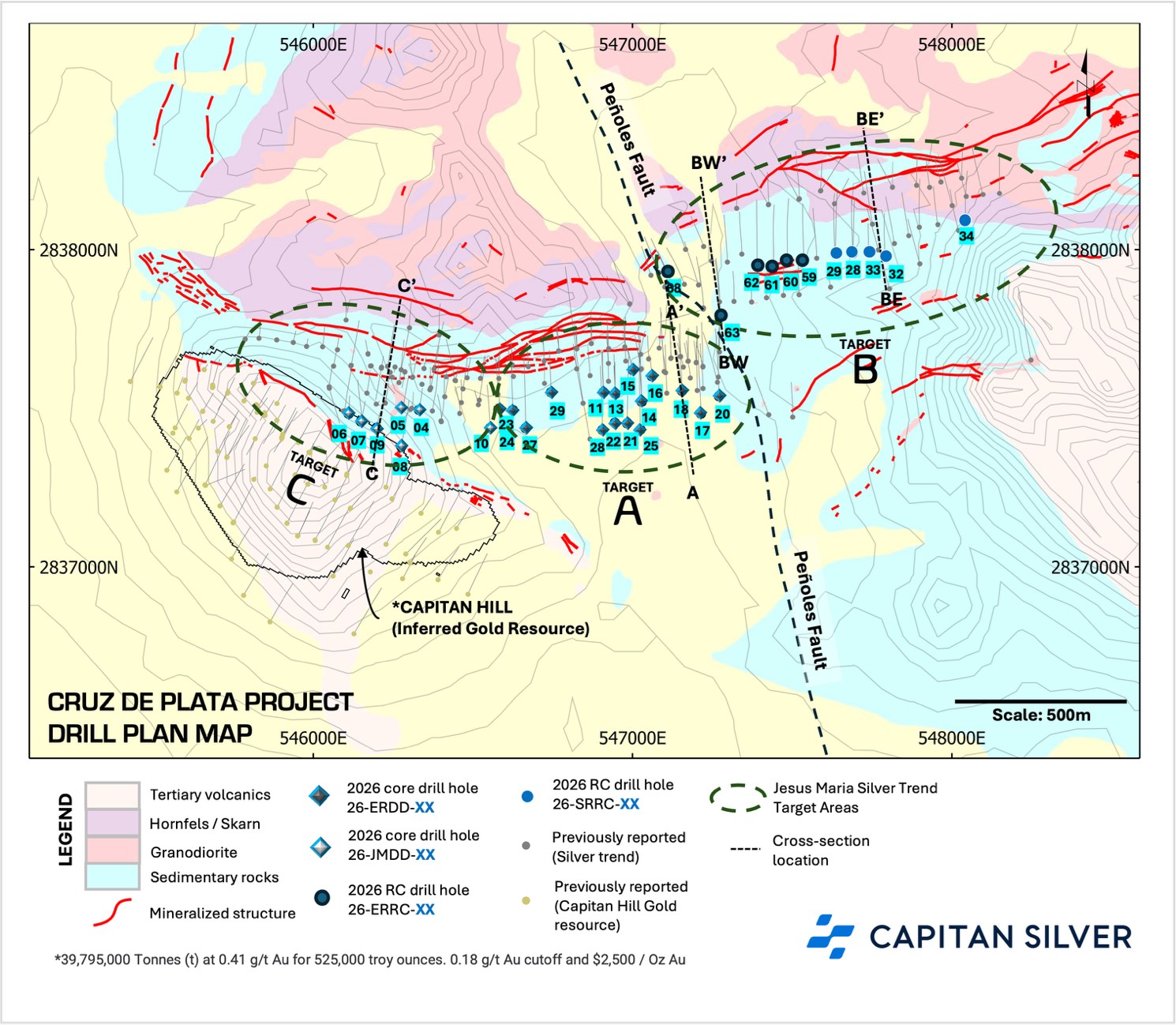
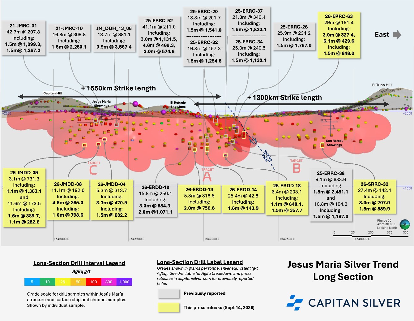
Capitan’s Jesus Maria Silver Trend Expands Drilled Strike Length to 2.8 km: Drilling continues to expand silver mineralization both at depth and on strike along the continuous 2.8 km Jesus Maria Silver Trend, with the Company returning multiple high-grade intercepts from all three target areas (See Figure 1)
Two (2) New High-Grade Silver Zones Discovered at Depth, East of the Peñoles Fault: Drill holes 26-ERRC-63 and 26-SRRC-32 represent two (2) of the widest and highest-grade intervals reported in this target area; both zones remain open along strike and at depth (see Figure 1, Target B)
Drill highlights include:
848.0 g/t AgEq over 1.5 m, within a wider interval of 29.0 m of 181.4 g/t AgEq, as well as a lower zone which returned 429.9 g/t AgEq over 1.5 m, within a wider zone of 3.0 m of 340.5 g/t AgEq in drill hole26-ERRC-63
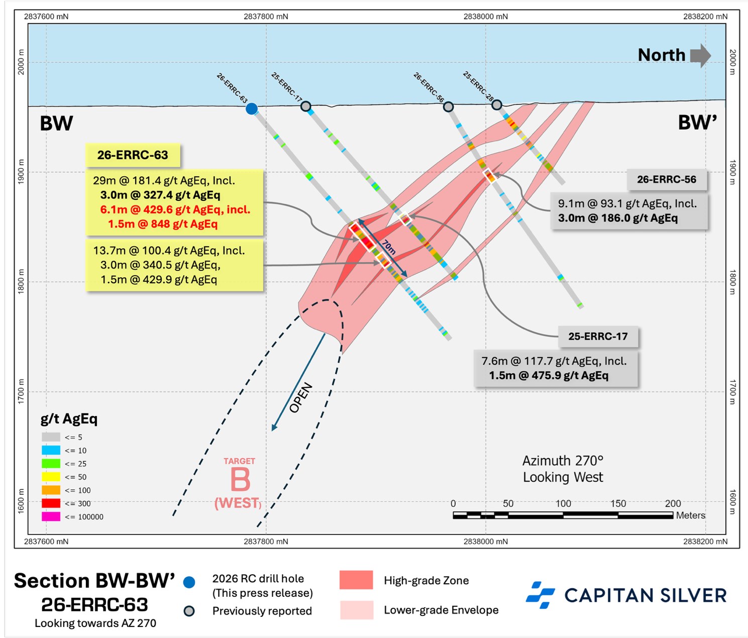
Drill hole 26-ERRC-63 intersected a 70 m wide zone of mineralization (see Figure 2)
889.9 g/t AgEq over 1.5 m, within a wider interval of 27.4 m of 142.4 g/t AgEq and a lower zone of 12.2 m of 63.6 g/t AgEq in drill hole 26-SRRC-32
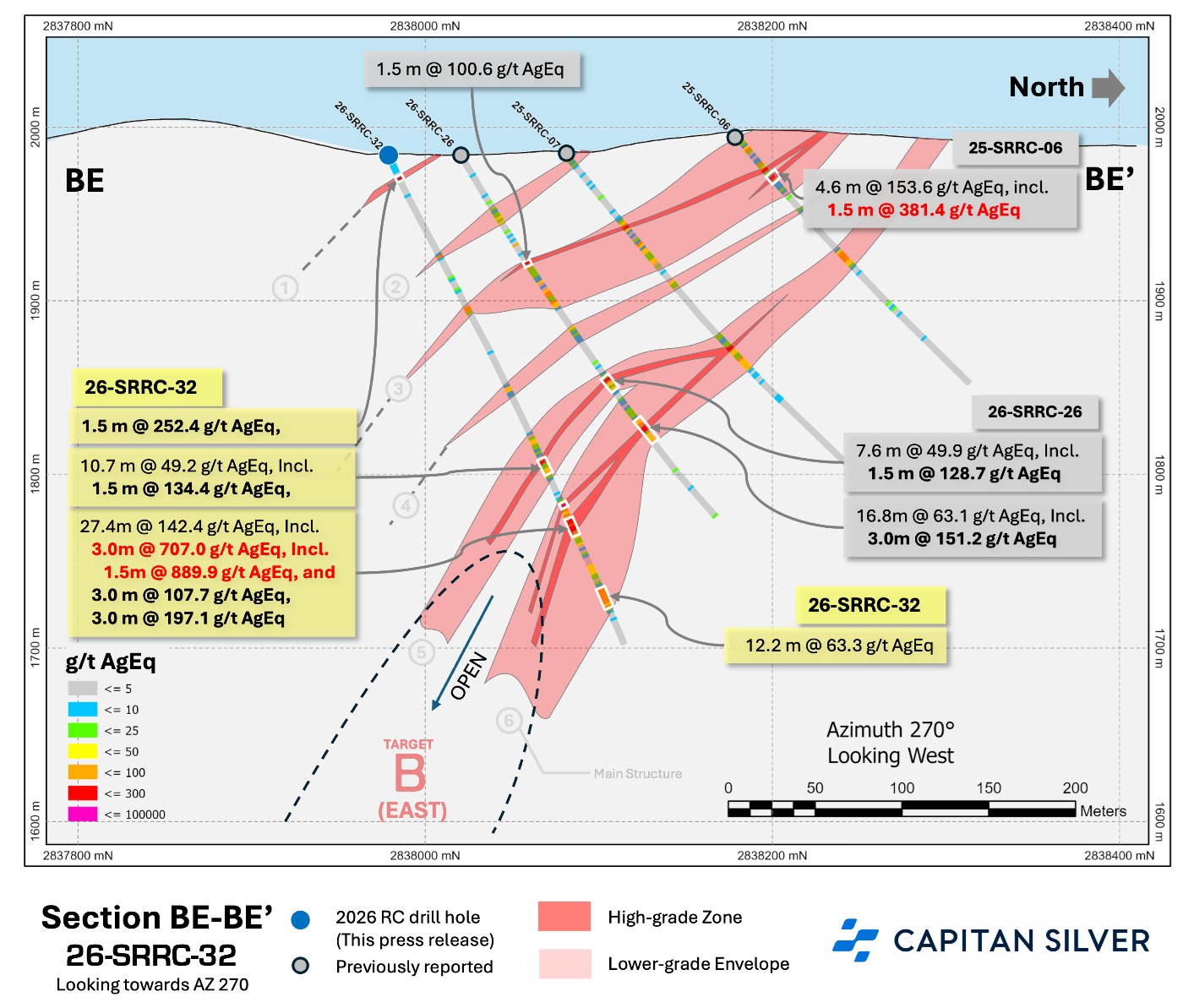
Drill hole 26-SRRC-32 intersected six (6) silver mineralized zones (see Figure 3)
1,363.1 g/t AgEq over 1.1 m, within a wider interval of 3.1 m of 731.3 g/t AgEq in an upper zone, with the middle zone returning 389.7 g/t AgEq over 1.6 m and 288.6 g/t AgEq over 1.3 m, within a wider interval of 11.6 m of 173.5 g/t AgEq and a lower zone of 198.8 g/t AgEq over 1 m, within 6.3 m of 82.6 g/t AgEq in drill hole 26-JMDD-09
1,123.6 g/t AgEq over 1.0 m and 597.2 g/t AgEq over 1.1 m, within a wider interval of 6.0 m of 125.3 g/t AgEq and a third mineralized zone which intersected 143.9 g/t AgEq over 1.8 m, within a wider interval 25.4 m of 42.8 g/t AgEq in drill hole 26-ERDD-14
368.9 g/t AgEq over 4.3 m, within a wider interval of 18.1 m of 159.2 g/t AgEq in drill hole 26-JMDD-06
798.7 g/t AgEq over 1.0 m, within a wider interval of 11.1 m of 192 g/t AgEq in drill hole 26-JMDD-08
756.6 g/t AgEq over 2.0 m, within a wider interval of 5.3 m of 316.8 g/t AgEq in drill hole 26-ERDD-13
632.2 g/t AgEq over 1.5 m, within a wider interval of 5.3 m of 313.7 g/t AgEq in drill hole 26-JMDD-04
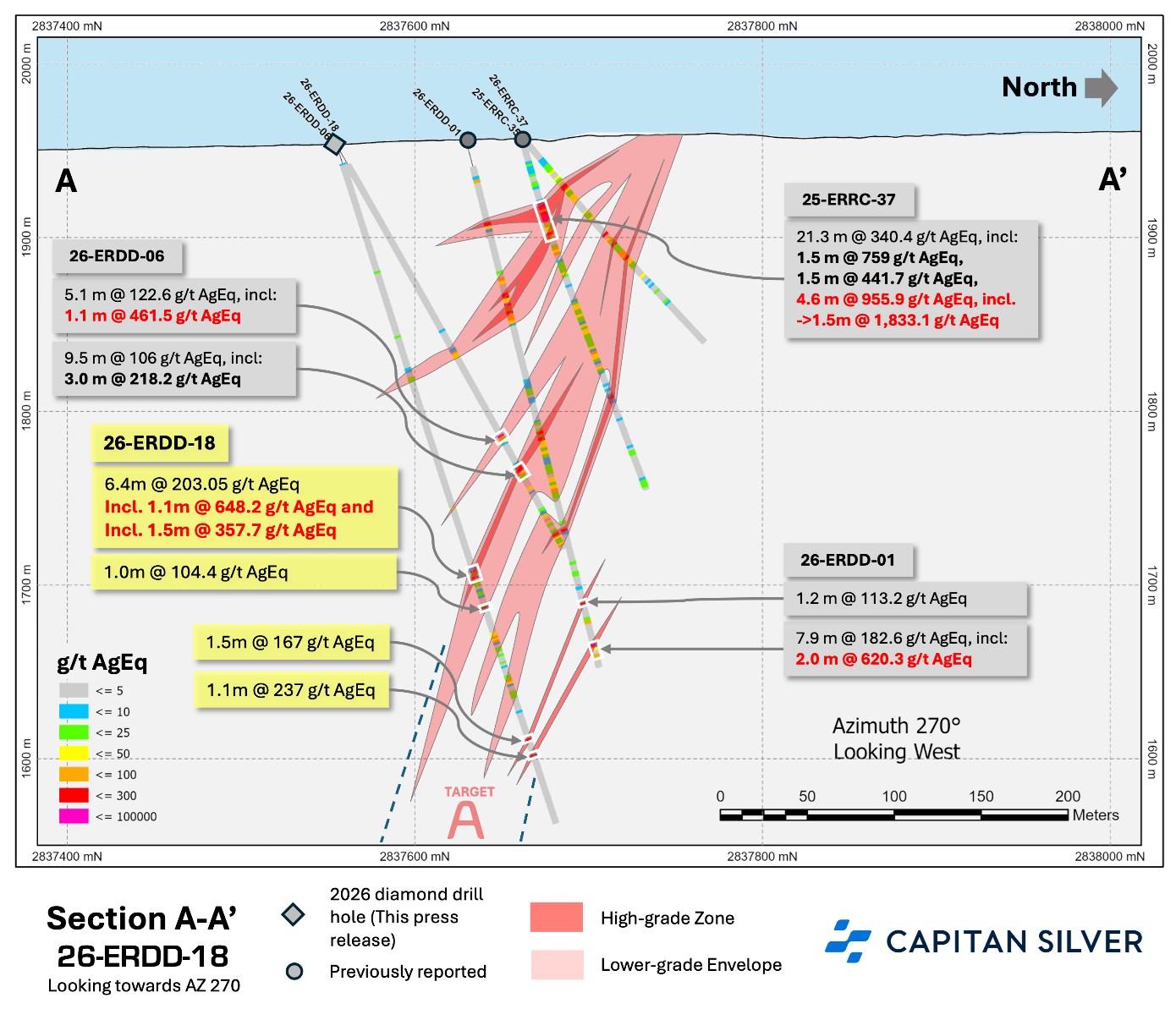
648.2 g/t AgEq over 1.1 m, within a wider interval of 6.4 m of 203.1 g/t AgEq in drill hole 26-ERDD-18
Upcoming Catalysts:
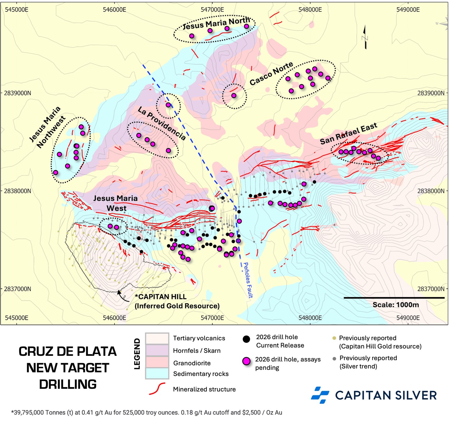
Assays pending for 78 drill holes in multiple priority targets: 31 core, 47 reverse circulation (“RC“) holes, with more arriving weekly (see new target drill plan map in Figure 7)
Acquiring new structural data: Pilot Televiewer Survey has commenced
Alberto Orozco, CEO of Capitan Silver, commented:
“I’m very pleased with the results from our 2026 drill program. The footprint of the Cruz de Plata continues to expand and confirms our thesis that we have a large, silver-rich mineralized system. Our most recent batch of assay results have returned an abundance of high-grade silver intercepts, which not only expand known mineralization to 2.8 km along the Jesus Maria Silver Trend, but also expand the mineralized envelope deeper. Most significant – and encouraging – is the fact that these results have also encountered high-grade mineralization in all three of our major target areas, which reinforces our confidence in the robustness and large-scale potential of this asset.”
The 2026 drill program at the Cruz de Plata project is fully ramped up, with four (4) drill rigs currently operating at site. Drilling through the late spring and summer focused on extending known zones of high-grade silver mineralization at depth over the entire strike length of the Jesus Maria Silver Trend (see Figure 1, Targets A, B, and C). This phase of drilling was executed primarily with diamond drilling, with some supporting RC holes. Down-dip step-outs varied between 35 to 150 m.
The remainder of the 60,000 m program for this area is focused on drilling the strike length of the Jesus Maria Silver Trend to a depth of 500 m vertically from surface with down-dip step outs increasing to 80 to 175 m with diamond drilling. The RC rig is now fully dedicated to drilling newly-permitted targets and has moved from a single to a double shift to increase the drill rate for the remainder of the program.
Drill Results: Target Area B
Recent drilling at Target Area B has resulted in the discovery of two (2) new high-grade zones of silver mineralization at depth, with grades approaching bonanza levels starting to appear in drilling.
Drill highlights from Target Area B include:
Drill hole 26-ERRC-63 intersected a 70 m wide zone of mineralization (see Figure 2), that includes a number of reported mineralized intervals:
848.0 g/t AgEq over 1.5 m, within a wider interval of 29. 0 m of 181.4 g/t AgEq, as well as a lower zone which returned 429.9 g/t AgEq over 1.5 m, within a wider zone of 3.0 m of 340.5 g/t AgEq
Drill hole 26-SRRC-32 intersected six (6) separate silver mineralized zones (see Figure 3). This includes:
889.9 g/t AgEq over 1.5 m, within a wider interval of 27.4 m of 142.4 g/t AgEq and a lower zone of 12.2 m of 63.6 g/t AgEq
Drill hole 26-ERRC-63 was drilled proximal to the hanging wall of the Peñoles Fault, which has demonstrated to be a controlling structure for mineralization on the stratigraphically higher west side of the fault (see previously reported drill holes 25-ERRC-12, 26, 35, 37).
This drill hole returned one of the most significant intersections of silver equivalent mineralization to date along this portion of the Jesus Maria Silver Trend, returning multiple intervals including an upper zone which returned 410.7 g/t AgEq over 1.5 m within a wider zone of 3.0 m of 327.4 g/t AgEq, 848 g/t AgEq over 1.5m, within a wider zone of 6.1 m of 429.6 g/t AgEq, all within a wider interval of 29 m of 181.4 g/t AgEq. The lower zone contained 429.9 g/t AgEq over 1.5 m, within a wider zone of 3.0 m of 340.5 g/t AgEq. This new high-grade zone remains open to expansion down-dip to the south and along strike to the east, with follow-up drilling currently being coordinated.
Drill hole 26-SRRC-32 intersected the second high-grade zone of silver mineralization in Target B in the vicinity of the historic San Rafael Mine. The hole returned six zones of mineralization (see Figure 3), of which the most significant was a lower zone (labeled as 6 in Figure 3), which contains 889.9 g/t AgEq over 1.5 m, within a wider zone of 3.0 m of 707 g/t AgEq, 107.7 g/t AgEq over 3.0 m and 197.1 g/t AgEq over 3.0 m, all within a wider interval of 27.4 m of 142.4 g/t AgEq.
These results confirm the Company’s current working geological thesis that this portion of the Jesus Maria Silver Trend has been dropped down several hundred metres by the Peñoles Fault, preserving the upper portions of the vertically zoned hydrothermal system, which is generally more gold dominated, and characterized by more widespread silica alteration and boiling textures in the higher, near surface portions. As exploration has continued to expand mineralization to depth, a transition to high-grade silver mineralization has started to evolve, with mineralization wide open to expansion at depth over this portion of the trend.
Drill Results: Target Area C
Drilling at Target Area C continued to return encouraging results, with drilling focused on extending mineralization down-dip from known high-grade zones in the vicinity of the historic Jesus Maria Mine.
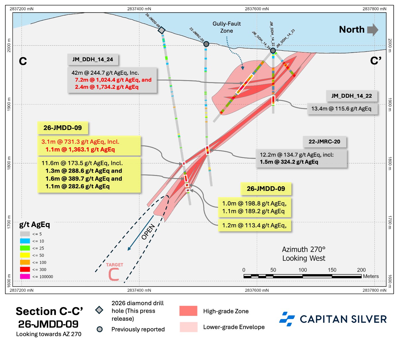
Drill holes 26-JMDD-04, 06, 07, 08, 09 and 10 all returned significant intervals of silver mineralization, with all holes reporting values more than 300 g/t AgEq, with bonanza grades greater than 1,000 g/t AgEq returned in drill hole 26-JMDD-09 (see Table 1 and Figure 4). All drill holes extended mineralization between 35 and 150 m down-dip from previously reported intersections.
Drill highlights from Target Area C include:
1,363.1 g/t AgEq over 1.1 m, within a wider interval of 3.1 m of 731.3 g/t AgEq in an upper zone, with the middle zone returning 389.7 g/t AgEq over 1.6 m and 288.6 g/t AgEq over 1.3 m, within a wider interval of 11.6 m of 173.5 g/t AgEq and a lower zone of 198.8 g/t AgEq over 1 m, within 6.3 m of 82.6 g/t AgEq in drill hole 26-JMDD-09
798.7 g/t AgEq over 1.0 m, within a wider interval of 11.1 m of 192 g/t AgEq in drill hole 26-JMDD-08
632.2 g/t AgEq over 1.5m, within a wider interval of 5.3 m of 313.7 g/t AgEq in drill hole 26-JMDD-04
368.9 g/t AgEq over 4.3 m, within a wider interval of 18.1 m of 159.3 g/t AgEq in drill hole 26-JMDD-06
At Target Area A, diamond core drilling continued to expand the main Jesus Maria Vein down-dip from the historic El Refugio Mine. The primary goal of this drilling is to extend previously reported high-grade silver mineralization to depth, with the secondary goal of exploring/infilling areas with poor drill density in the vicinity of the Target C and Target A boundary.
The best intercept in this zone was in drill hole 26-ERDD-14, which intersected up to 1,123.6 g/t AgEq over 1.0 m. Five of the holes returned grades in excess of 500 g/t AgEq, with the majority of the holes intersecting values in excess of 200 g/t AgEq.
Drill highlights from Target Area A include:
1,123.6 g/t AgEq over 1.0 m and 597.2 g/t AgEq over 1.1 m, within a wider interval of 6.0 m of 125.3 g/t AgEq and a third mineralized zone which intersected 143.9 g/t AgEq over 1.8 m, within a wider interval 25.4 m of 42.8 g/t AgEq in drill hole 26-ERDD-14
648.2 g/t AgEq over 1.1 m, within a wider interval of 6.4 m of 203.1 g/t AgEq in drill hole 26-ERDD-18
756.6 g/t AgEq over 2.0 m, within a wider interval of 5.3 m of 316.8 g/t AgEq in drill hole 26-ERDD-13
643.1 g/t AgEq over 0.9 m in drill hole 26-ERDD-23
538.7 g/t AgEq over 1.7 m, within a wider interval of 5.2 m of 285.2 g/t AgEq in drill hole 26-ERDD-27
305.5 g/t AgEq over 1.3 m, within a wider interval of 25.6 m of 85.0 g/t AgEq in drill hole 26-ERDD-29
Drilling at Target area A continues to extend mineralization at depth with base metal tenors continuing to increase as drilling targets deeper and higher temperature portions of the mineralized system. The Company anticipates base metals tenors to continue to increase at depth, similar to what is seen to the west at the Jesus Maria Mine area.
AgEq considers Ag, Au, Pb and Zn and calculated as follows: AgEq = Ag g/t + (80x Au g/t) + (0.003 x Pb g/t) + (0.0037 x Zn g/t). High grades have not been capped. RC and Diamond Core Drill samples have been analysed at SGS labs in Durango and Hermosillo using fire assay and Four-acid multi-element analysis with the following codes: GE-FAA30V6 and GEICP40Q12, with over assays using the following codes: GO_FAG37V for Au and Ag. QAQC: Capitan Silver maintains a rigorous QAQC program and inserts multiple standards, blanks and duplicates into the sample stream at regular intervals. Check Assays are performed at ALS laboratories in Zacatecas, Mexico. True widths along the Jesús María Trend are estimated to be 70-90% of the drilled width. At new drill targets/discoveries, true widths are unknown. Intervals are calculated at a 25 g/t AgEq cut-off and are cut at a maximum of 3 metres of internal dilution. Some numbers may not sum correctly due to rounding.
Qualified Person
The scientific and technical information in this news release has been reviewed and approved by Marc Idziszek, P.Geo, Vice President Exploration of Capitan, and a “qualified person” (with the meaning of National Instrument 43-101 – Standards of Disclosure for Mineral Projects).
About Capitan Silver Corp.
Capitan Silver is defining a new high-grade silver system at its Cruz de Plata project, located in the heart of Mexico’s primary silver belt. The Company is led by a proven and accomplished management team that has previously advanced three projects into production, on time and on budget. The Company has been diligent in maintaining a tight share structure and has one of the tightest share structures among its peer group, with the top three shareholders owning approximately 37% of the Company’s share capital. Capitan Silver is fully funded and actively drilling at its Cruz de Plata silver project.
CAUTIONARY STATEMENT REGARDING FORWARD-LOOKING INFORMATION
Certain statements contained in this news release constitute “forward-looking statements“ within the meaning of applicable Canadian securities legislation (collectively, “forward-looking statements“). All statements, other than statements of historical fact, contained in this news release are forward-looking statements. These forward-looking statements, by their nature, require Capitan to make certain assumptions and necessarily involve known and unknown risks and uncertainties that could cause actual results to differ materially from those expressed or implied in these forward-looking statements. Forward-looking statements are not guarantees of future performance.
Forward-looking statements may be identified by the use of words or phrases such as “may“, “will“, “would“, “could“, “should“, “expect“, “believe“, “plan“, “anticipate“, “intend“, “estimate“, “continue“, “objective“, “potential“, “target“, “strategy“, “project“, “forecast“, “outlook“, “scheduled“, “seek“, “explore“ and other similar terminology, as well as terms usually used in the future and the conditional, and the negatives thereof, or comparable terminology, are intended to identify forward-looking statements. In particular, but without limiting the foregoing, this news release contains forward-looking statements with respect to: expectations regarding the Company’s 2026 drilling program at the Cruz de Plata project, including the planned 60,000-metre multi-rig program; anticipated timing and results of future assay results; the potential scale, continuity, and grade of mineralization at the Cruz de Plata project; the potential to expand known zones of mineralization; the prospectivity of the Cruz de Plata project and its exploration potential; management’s beliefs regarding the mineralized system at Cruz de Plata; and the Company’s strategy and exploration objectives.
The forward-looking statements contained in this news release are based upon certain material assumptions that were applied in drawing a conclusion or making a forecast or projection, including assumptions and expectations regarding: the continued validity of exploration results and geological interpretations; the ability to complete planned exploration programs on time and within budget; the availability of financing for future exploration and development activities; commodity prices remaining at levels that support continued exploration; the ability to obtain and maintain all necessary permits and approvals; the accuracy of current mineral resource estimates; the continuity of mineralization between drill holes; and general economic and business conditions. Although the Company believes that the assumptions underlying these forward-looking statements are reasonable, they may prove to be incorrect, and the Company cannot assure investors that actual results will be consistent with these forward-looking statements.
Forward-looking statements involve known and unknown risks, uncertainties and other factors which may cause the actual results, performance or achievements of the Company to be materially different from any future results, performance or achievements expressed or implied by the forward-looking statements. Such risks and uncertainties include, but are not limited to: exploration and development risks, including risks related to the interpretation of geological data and exploration results; the uncertainty of mineral resource estimates; risks inherent in the mining industry including environmental hazards, industrial accidents, unusual or unexpected geological formations, pressures, cave-ins, flooding, and the risk of inadequate insurance or inability to obtain insurance; fluctuations in commodity prices; currency exchange rate fluctuations; risks related to obtaining and maintaining necessary permits and licenses; risks related to the Company’s title to its mineral properties; risks related to the political and economic climate in Mexico; regulatory changes; reliance on key personnel; competition in the mining industry; risks related to the Company’s ability to raise additional capital; dilution to existing shareholders; risks related to global economic conditions and market volatility; environmental risks and hazards; and other risks and uncertainties described in the Company’s public filings.
The foregoing list of risks and uncertainties is not exhaustive. For a more complete discussion of the risk factors affecting the Company, readers are encouraged to review the Company’s filings available on SEDAR+ (www.sedarplus.ca) under the Capitan’s issuer profile.
Although the Company has attempted to identify important factors that could cause actual actions, events or results to differ materially from those described in forward-looking statements, there may be other factors that cause actions, events or results to differ from those anticipated, estimated or intended. Forward-looking statements contained herein are made as of the date of this news release and the Company disclaims any obligation to update any forward-looking statements, whether as a result of new information, future events or results or otherwise, except as required by applicable securities laws. There can be no assurance that forward-looking statements will prove to be accurate, as actual results and future events could differ materially from those anticipated in such statements. Accordingly, readers should not place undue reliance on forward-looking statements.
Neither the TSX Venture Exchange nor its Regulation Services Provider (as that term is defined in the policies of the TSX Venture Exchange) accepts responsibility for the adequacy or accuracy of this release. No stock exchange, securities commission or other regulatory authority has approved or disapproved the information contained herein.
10.19 g/t AuEq over 10.50 m marks the highest-grade intercept of down-plunge extension
VANCOUVER, British Columbia, Sept. 14, 2026 (GLOBE NEWSWIRE) — Blue Jay Gold Corp. (TSXV: JAY) (OTCQB: JAYGF) (FSE: JAY) (“Blue Jay” or the “Company“), is pleased to announce the first assay results from its maiden 2026 diamond drill program at the Steller Gold Project (“Steller” or the “Project“) in the Yukon Territory. Hole SC26-003 returned 14.00 metres (m) of 6.15 grams per tonne (g/t) gold (Au) and 124 g/t silver (Ag), or 8.04 g/t gold equivalent (AuEq), from 495.00 m, including 10.50 m of 7.84 g/t Au and 154 g/t Ag (10.19 g/t AuEq). The intersection represents an approximate 32 m down-plunge extension of the mineralization intersected in drill hole SC21-027, which returned 14.8 m of 5.79 g/t Au and 100.9 g/t Ag in 20211. The results highlight continuity of the mineralization and its host structure across multiple intercepts, with room for further expansion. The system displays an intermediate sulfidation epithermal style comparable to giant districts such as Fresnillo, Zacatecas and Pachuca in Mexico. Intercepts extending from surface to over 500 m down dip demonstrate the continuity and scale potential of the Skukum Creek system. Initial drilling at Mt. Skukum, the site of historical gold production between 1986 and 1988, returned 0.5 m of 57.4 g/t Au and 44.1 g/t Ag from 160.8 m in hole MS26-001. The historical high-grade production at Mt. Skukum, combined with the presence of multiple undertested vein sets, points to resource growth potential on this target corridor. The Company has identified similar potential for expansion along strike at other target areas across the Project’s 170 km² land package.
“SC26-003 is the kind of result we underwrote when we bought this project,” said Geordie Mark, CEO of Blue Jay Gold. “It confirmed mineralization more than 30 metres down-plunge of SC21-027, drilled in 2021, with effectively the same width, grade and grade distribution. That is what continuity looks like: not just a string of separate hits, but a zone you can follow. We identified this area as being completely open to depth and down-plunge. That was the call, and we have delivered results that exemplify our thesis.”
Most exploration programs start with a blank map. Steller handed us one already partly drawn, aided by historical drilling, 7.5 kilometres of underground development, and a high-grade resource in the ground. What has never existed is a structural framework that explains where the grade goes, and a hydrothermal model that predicts where other mineralized systems could be.”
“Hyperspectral core logging is central to how we are building it,” added Mark. “We have now put roughly 18,000 metres of historical core through the scanner system, reading alteration mineral distribution and chemistry directly from the core ahead of assay results from the lab. It shows a consistent, zoned alteration envelope around the mineralized structures that points toward mineralization. Every metre we scan turns rock we already own into data we can use to refine targets.
At Mt. Skukum, our first hole returned a high-grade intercept at the site of the former Mt. Skukum mine, which produced gold between 1986 and 1988. Seeing grades of that order in our own first holes tells us the system at Steller is not confined to a single deposit.
We are only about 3 months after listing, and the picture we formed in due diligence of Steller is holding. Rigs are turning and assays are pending on further holes. Today’s results are the first assay confirmation that the framework we are building points the right way.”
Highlights
High-grade down-plunge extension at Rainbow Zone at Skukum Creek: 14.0 m of 6.15 g/t Au and 124.1 g/t Ag (8.04 g/t AuEq) from 495.0 m in SC26-003, including 10.50 m of 7.84 g/t Au and 154.0 g/t Ag (10.19 g/t AuEq), approximately 32 m below SC21-027 (14.8 m of 5.79 g/t Au, 100.9 g/t Ag) (Figure 1).
Mineralization is continuous within the structure between drill holes: SC26-003 returned essentially the same width and grade as SC21-027, which is >30 m up-plunge. The structure carries consistent gold and silver tenor between the two holes rather than occurring as isolated lenses.
Our interpretation, now drill-tested: we projected that this zone was open. SC26-003 is the first drilling phase to test it and has unearthed that reality.
Hyperspectral logging of 18,000 m of core has produced a vectoring tool: a consistent, zoned alteration envelope wrapped around the mineralized structures, measurable directly in core and applicable to material already in the core yard. It has generated new targets along the Skukum Creek Structural Corridor.
First drilling at Mt. Skukum returns high-grade gold: MS26-001 returned 0.5 m of 57.4 g/t Au from 160.8 m, on the site of the former Mt. Skukum gold mine, which recovered 77,790 ounces of gold between 1986 and 1988.
Initial batch of many: 5 holes are reported today, with assays pending for further holes that have been completed. Mineralization at Skukum Creek remains open down-plunge and along strike, and rigs are turning.
2026 Technical Report. TECHNICAL REPORT AND UPDATED MINERAL RESOURCE ESTIMATE OF THE STELLER GOLD PROJECT, WHITEHORSE MINING DISTRICT, YUKON TERRITORY, CANADA. P&E Mining Consultants Inc. Effective Date: Oct. 31, 2025. Cut-off: 3.0 g/t AuEq. Au: US$2,850/oz. Ag: US$34.20/oz. AuEq ratio = Au:Ag 85.6:1
Cross-section through the Rainbow zone that highlights the continuity of the Au-Ag mineralization, and the >30 metre down dip extension of SC-26-003 compared with the most proximal intersection (SC-21-027). Holes being surveyed during drilling.
Figure 1: Cross-section through the Rainbow zone that highlights the continuity of the Au-Ag mineralization, and the >30 metre down dip extension of SC-26-003 compared with the most proximal intersection (SC-21-027). Holes being surveyed during drilling.
Table 1: Assay Results
Location
From (m)
To (m)
Au (g/t)
Ag (g/t)
AuEq (g/t)1
Interval (m)
Skukum Creek
SC-26-003
495.00
509.00
6.15
124.0
8.04
14.00
including
498.50
509.00
7.84
154.0
10.19
10.50
And including
499.60
504.00
12.00
258.0
15.94
4.40
SC-26-001
444.63
448.96
4.63
74.0
5.76
4.33
SC-26-004*
377.00
378.00
1.15
0.2
1.15
1.00
Mt. Skukum
MS (26-01)
160.80
161.30
57.40
44.1
58.07
0.50
This press release is reporting on the first three holes at Skukum Creek hole 1, 3 and 4 and holes 1 and 4a at Mt. Skukum which is 200 samples in total. True widths are estimated at approximately 60-80 % of the down-hole interval based on currently available results and observations. Interval average grades are calculated using un-capped assays. Composites are calculated using a 1.0 g/t AuEq cut-off grade with a maximum of 2.0 m of internal dilution of below-cut-off material and a minimum composite length of 1.0 m.
Gold equivalent (AuEq) is calculated as AuEq (g/t) = Au (g/t) + [Ag (g/t)]*($67*0.93/$4300*0.95)], using US$4,300/oz gold and US$67.00/oz silver. Project recoveries of 95% for gold and 93% for silver and are consistent with the assumptions used in the Mineral Resource Estimate with an effective date of October 31, 2025. AuEq values are provided for comparison only and do not reflect payable metal.
Hole SC26-001 returned 4.33 m of 4.63 g/t Au and 74.0 g/t Ag (5.76 g/t AuEq) from 444.63 m to 448.96 m, lending further support to the continuity of mineralization at Skukum Creek. Hole SC26-004 deviated from its planned trajectory and did not reach its intended target, returning 1.00 m of 1.15 g/t Au and 0.2 g/t Ag (1.15 g/t AuEq) from 377.00 m to 378.00 m in a separate zone for subvertical Au-Ag mineralization. The Company plans to re-drill this target in a future phase of the program.
Skukum Creek Plan Section showing drill traces for initial holes from 2026, compared with historical holes on the Northeast portion of the deposit area. Note that SC-26-004 drill hole deviated off target and out of structural plane.
Figure 2: Skukum Creek Plan Section showing drill traces for initial holes from 2026, compared with historical holes on the Northeast portion of the deposit area. Note that SC-26-004 drill hole deviated off target and out of structural plane.
Table 2: Drill Hole Collar Locations
Hole ID
East
North
Elevation
Depth
Dip
Azimuth
SC-26-001
478102
6671141
1386
529
-52
300
SC-26-003
478102
6671141
1386
542
-56
307.5
SC-26-004
478102
6671141
1386
537
-56
314.5
MS-26-001
473531
6674889
1913
222
-66.5
065
MS-26-004A
473455
6674883
1916
213
-54
112
Next Steps
Drilling is ongoing. Follow-up holes are being planned to test further down-plunge and along strike continuity of mineralization on the Rainbow zone. Drill results are expected to be delivered from Skukum Creek and other target areas on Steller during and post the completion of the exploration program.
Drilling and Geology Discussion
Structural Setting and Controls on Mineralization
The 2026 Skukum Creek drill program is testing structural extensions to Au-Ag mineralization hosted within composite breccia-shear zones. These zones acted as fluid conduits and record multiple pulses of overprinting hydrothermal alteration, Au-(Ag) mineralization and coeval felsic to intermediate dyking, all formed during the Eocene. This system is comparable to major epithermal districts including Guanajuato, Pachuca-Real del Monte, Fresnillo and Tayoltita in Mexico, and the Comstock district in Nevada and Creede in Colorado in the United States. These districts share a similar Eocene-Oligocene age and formed within calderas and large volcanic complexes, comparable to the geological systems preserved across the Stellar project.
Rainbow Zone Down-Plunge Extension
The holes reported today are the first tranche of results from the 2026 program and test the down-plunge extension of the Rainbow Zone.
SC26-003 extends high-grade Au-Ag mineralization >30 m down-plunge of SC-21-027, drilled in 2021. The intersection grades 8.04 g/t AuEq. over 14 m and preserves the across-structure grade distribution seen up-plunge. Equally important, the holes confirm that the bounding structures are continuous and that they remained active as conduits through repeated pulses of hydrothermal alteration, mineralization and Eocene dyking. This dyking is comparable to that found in the Mexican examples of major intermediate sulfidation systems, which can extend more than 1 km vertically and 8 km along strike, forming multi-million AuEq systems that enjoyed protracted mining histories. Our framework exploration represents the first systematic integration of Steller’s historical data within the geological context of these major epithermal systems and the application of next generation geological tools (e.g., LithologIQ) to unravel Stellar’s potential.
Not to be overlooked, SC26-001 returned 4.33 metres grading 5.70 g/t AuEq. on the Rainbow Zone and importantly shows continuity of the structure that hosts mineralization. The Au-Ag mineralization is hosted within composition vein-breccia that is spatially associated with the same alteration patterns witnessed in SC26-003, as such we are developing an improved confidence in the hydrothermal evolution of this system.
Hyperspectral Core Logging and Alteration Zoning
Blue Jay has completed hyperspectral logging of approximately 18,000 m of archived drill core. The results show a consistent, zoned alteration envelope along and up-dip of the mineralized structures. Measured as down-hole lengths outward from the mineralized zone, the envelope grades from an outer white-mica-rich halo of more than 100 m, through an inner halo of up to 90 m in which chlorite becomes progressively more Fe-rich, to a proximal zone of tens of metres in which hydrothermal carbonate is Mg-rich.
The practical value is vectoring. The zoning is measurable in core, it repeats across holes, and it can be applied to material already in the core yard. It has generated new targets within the strike length of the mineralized corridor. This begins to define the scale potential for multiple target areas that warrant broad step out drilling.
The Skukum Creek Structural Corridor
Skukum Creek mineralization is currently defined over a strike length of more than 1 km. It sits within the Skukum Creek Structural Corridor, which extends for more than 15 km as defined by regional magnetic data and comprises a zone of multiple sub-parallel and curvilinear structures: the continuity and distribution of these structures were unmapped before magnetics could be interrogated.
These structures are interpreted as second order features relative to a longer-wavelength, north-south trending, deeper penetrative structure that shows spatial association with Eocene dyke swarms. Both the corridor length and the structural hierarchy are interpretations drawn from airborne magnetics, that was reprocessed and reinterpreted in 2026.
District-Scale Associations
The same spatial and temporal associations between alteration, mineralization, dyking and dilation are seen at Raca, at Goddell Gully, and more broadly across the Tellurium-rich, low sulphidation epithermal vein field at Mt. Skukum. North-south and east-west trending composite dyke swarms are documented across that field and around Skukum Creek, Raca, Chieftain and Goddell. Comparable associations are mapped historically along east-west trending composite dyke sets of rhyolitic, andesitic and quartz-feldspar porphyry composition east of Skukum Creek, where copper- and molybdenum-bearing mineralization is also present.
At depth in the altered footwall of the Rainbow Zone, a sub-population of quartz-pyrite-molybdenite veins has been documented. These form part of a hydrothermal evolution progressing from early potassic alteration, through localized magnetite alteration and sericite-quartz-chlorite alteration, to Au-Ag mineralization with Mg-rich carbonate, and finally to late low-temperature epithermal quartz veining. This progressive hydrothermal, magmatic and chemical evolution bears similarities to the geological systems documented in Guanajuato and Creede Colorado.
That progression, together with the copper-molybdenum mineralization east of Skukum Creek and the quartz-feldspar porphyry dykes, is interpreted as consistent with hydrothermal centres being driven by magmatic intrusions at depth. No drilling has ever tested that integrated interpretation, and no such target construction has been defined before.
Oriented Core
Oriented core is being collected at Steller and will be used for the first time in the property’s history. It is one of the defining elements of this framework year of exploration and gives Blue Jay the capacity to target future drilling across a project that shows district-scale mineralization with broad commonalities within a major regional architecture.
Market Making Engagement
The Company announces that it has engaged the services of ICP Securities Inc. (“ICP”) to provide automated market making services, including use of its proprietary algorithm, ICP Premium® in compliance with the policies and guidelines of the TSX Venture Exchange (the “Exchange“) and other applicable legislation. ICP will be paid a monthly fee of C$7,500, plus applicable taxes. The agreement between the Company and ICP was signed with a start date of September 10th, 2026, and is for four (4) months (the “Initial Term”) and shall be automatically renewed for subsequent one (1) month terms (each month called an “Additional Term”) unless either party provides at least thirty (30) days written notice prior to the end of the Initial Term or an Additional Term, as applicable. There are no performance factors contained in the agreement and no stock options or other compensation in connection with the engagement. ICP and its clients may acquire an interest in the securities of the Company in the future. The Company’s engagement of ICP remains subject to the approval of the Exchange.
ICP is an arm’s length party to the Company. ICP’s market making activity will be primarily to correct temporary imbalances in the supply and demand of the Company’s shares. ICP will be responsible for the costs it incurs in buying and selling the Company’s shares, and no third party will be providing funds or securities for the market making activities.
Quality Assurance and Quality Control
Drill core was transported from the drill platform to the logging facility where it was logged, photographed, and samples split by diamond saw. Samples were then bagged, and a blank, duplicate or certified reference material inserted into the sample stream every 10 samples. Samples were submitted by hole, and placed in large sacks, sealed with numbered tags in order to maintain a chain-of-custody, and transported to ALS Laboratories in Whitehorse, Yukon where they were shipped by ALS to the prep and analytical lab in North Vancouver, British Columbia.
Individual samples were crushed to 2mm (10 mesh) and a 250g split was ground until at least 85% of the material passes through a 75-micron (75 µm / <200 mesh) screen. Samples were prepared for analysis according to ALS method ME-MS61 where multi-element (48) geochemical analysis was performed by four-acid digest of a 0.25g split followed by a combination of ICP-AES and ICP-MS finishes. Over-limits for gold and silver samples were re-analyzed using ALS method ME-GRA21 where a 30g split is analyzed with fire assay and gravimetric finish.
All results passed the QA/QC screening at the lab, all company inserted standards and blanks returned results that were within acceptable limit.
Qualified Person
The scientific and technical content of this news release has been reviewed and approved by Freeman Smith, P.Geo., VP Exploration of Blue Jay Gold Corp., who is a Qualified Person as defined by National Instrument 43-101 – Standards of Disclosure for Mineral Projects.
About ICP Securities Inc.
ICP Securities Inc. is a Toronto based CIRO dealer-member that specializes in automated market making and liquidity provision, as well as having a proprietary market making algorithm, ICP Premium®, that enhances liquidity and quote health. Established in 2023, with a focus on market structure, execution, and trading, ICP has leveraged its own proprietary technology to deliver high quality liquidity provision and execution services to a broad array of public issuers and institutional investors.
About Blue Jay Gold Corp.
Blue Jay Gold Corp. is a Canadian gold exploration company focused on growing and discovering resources within established gold producing regions in Canada. The Company’s flagship asset is the 100%-owned Steller Gold Project in southern Yukon, an infrastructure-supported, past-producing mine with significant exploration upside and clear near-term catalysts. Blue Jay has also built a portfolio of projects in Ontario. With strategically located assets and a leadership team experienced in geology and capital markets, Blue Jay will advance disciplined, modern exploration programs focused on target definition, resource growth, and new discoveries in known gold-mineralized regions. For more information, please visit: www.bluejaygoldcorp.com.
Eric Negraeff Investor Relations Blue Jay Gold Corp. eric@bluejaygoldcorp.com Phone: (604) 235-4059
Cautionary Note Regarding Forward-Looking Statements Certain statements in this press release contain forward-looking information. Forward-looking information involves risks, uncertainties and other factors that could cause actual results to differ materially from those expressed or implied by such forward-looking information. In addition, the forward-looking statements require management to make assumptions and are subject to inherent risks and uncertainties. There is significant risk that the forward-looking statements will not prove to be accurate, that the management’s assumptions may not be correct and that actual results may differ materially from such forward-looking statements.
These statements can be identified by the use of forward-looking terminology (e.g., “expect”,” estimates”, “intends”, “anticipates”, “believes”, “plans”). Forward-looking statements contained in this press release may include, but are not limited to, the results of the Skukum Creek drill program (including drilling of the Rainbow Zone and other areas of Steller), the timing and scope of the rest of the Company’s exploration program, and future business plans of the Company. Such information involves known and unknown risks, including the receipt of regulatory approval, the results of future financing and exploration activities, the interpretation of exploration results and other geological data, or unanticipated costs and expenses and other risks identified by Blue Jay in its public securities filings that may cause actual events to differ materially from current expectations. Readers are cautioned not to place undue reliance on these forward-looking statements, which speak only as of the date of this press release. Except as required by applicable securities laws and regulation, Blue Jay disclaims any intention or obligation to update or revise any forward-looking statement, whether as a result of new information, future events or otherwise.
DALLAS, TX / ACCESS Newswire / September 11, 2026 / AIAI Holdings Corporation (NASDAQ:AIAI) (“Ai2” or the “Company”), an AI-enabled diversified holding company utilizing Transformational AI (TAI) to enhance portfolio performance announced today that it has entered into amendments to its existing lock-up agreements entered into in connection with the Company’s direct listing with holders of the Company’s outstanding shares of Class A Common Stock. The list of those signing the amendment includes the Company’s founder and Chairman, other members of the Company’s board of directors, members of management and a majority of its largest stockholders.
The revised release schedule incorporates a layered approach to share restrictions, with certain release dates being extended and the applicable percentages distributed over a longer period of time. The amended lock-up agreement extends restrictions on the sale of 70% of the shares restricted under the current lock-up agreements until mid-February 2027 when the restrictions fall to 50%. Restrictions then fall to 30% of the restricted shares in mid-March with the final 30% falling away entirely in mid-April 2027.
“We remain focused on protecting and enhancing long-term shareholder value,” said Todd Furniss Chief Executive Officer and Co-Founder of AIAI Holdings Corporation. “The adoption of this revised restriction schedule reflects our commitment to disciplined capital management, responsible stewardship and a measured approach to managing our share structure. We believe this approach is in the best interests of the Company and our shareholders at this time.”
AIAI Holdings Corporation (Ai2) (NASDAQ:AIAI) is an AI-enabled diversified holding company that acquires and grows companies across multiple industries. We expect to drive revenue and earnings growth throughout our portfolio by applying exclusively licensed Transformational AI to enhance operational efficiency and financial performance.
Ai2 is building a next-generation model for technology-enabled business operations, which is expected to create sustainable value for shareholders through the strategic integration of artificial intelligence across diverse industries.
This press release contains “forward-looking statements” or “forward-looking information” within the meaning of the Private Securities Litigation Reform Act of 1995, including statements regarding the plans, intentions, beliefs, and current expectations of the Company with respect to future business activities and plans of the Company. All statements contained in this press release that do not relate to matters of historical fact should be considered forward-looking statements, including without limitation statements regarding our expectations, intentions, beliefs, plans, objectives, goals, strategies, future events or performance, and underlying assumptions. Forward-looking statements are often identified by the use of words such as “may,” “will,” “expect,” “believe,” “anticipate,” “intend,” “would,” “could,” “should”, “estimate,” “plan,” “predict,” “project,” “estimate”, or “continue,” or similar expressions, including the negative of these terms or other comparable terminology.
Forward-looking statements are based on the Company’s current expectations regarding its strategy, plans, intentions, performance, or future occurrences or results, the information on which such expectations were based may change. These forward-looking statements rely on a number of assumptions concerning future events and are subject to a number of known and unknown risks, uncertainties, and other factors, many of which are outside of the Company’s control, that could cause actual results, performance, or achievements to materially differ from any future results, performance, or achievements expressed or implied by the forward-looking statements. Such risks, uncertainties and other factors include, but are not limited to our lack of operating history, our ability to attract new investments, our failure to manage growth effectively, our acquisition activities may pose risks that could harm our business, and our licensed AI may not perform up to the expected standards, as well as general business and economic conditions, competitive pressures, regulatory changes, technological developments, and other factors identified in the Company’s most recent filings with the U.S. Securities and Exchange Commission, including our Registration Statement on Form S-1, which are available for review at www.sec.gov. Furthermore, the Company operates in a competitive environment where new and unanticipated risks may arise. Accordingly, investors should not place any reliance on forward-looking statements as a prediction of actual results.
The forward-looking statements in this press release are based on information available to us as of the date hereof, and we disclaim any intention to, and, except as may be required by law, undertake no obligation to, update or revise forward-looking statements to reflect events or circumstances that subsequently occur or of which the Company hereafter become aware. These forward-looking statements should not be relied upon as representing our views as of any date subsequent to the date of this press release.
The platinum market is forecast to return to a modest surplus in 2026, but the improvement says little about the industry’s ability to produce more metal.
The World Platinum Investment Council (WPIC), an industry body funded by major global platinum producers, expects a 265,000-ounce surplus this year after the market recorded a revised deficit of 1.44 million ounces (Moz) in 2025. Yet global mine supply is forecast to remain broadly flat at 5.55 Moz, with the entire 2% increase in total supply coming from recycling.
The findings come as the WPIC publishes its Platinum Quarterly for the second quarter of 2026, including a full-year market forecast.
Although WPIC focuses on platinum, the metal is mined as part of a wider basket of PGMs including palladium, rhodium, iridium, ruthenium and osmium. Its analysis therefore also highlights the broader supply challenges facing PGM miners.
The surplus is therefore largely a consequence of weaker investment demand rather than a meaningful increase in primary production. WPIC expects total demand to fall 18% in 2026, principally because of lower investment demand, while above-ground stocks are forecast to end the year at just over 3.4 months of global demand.
For miners, the more important question is why primary production has proved so difficult to increase despite three consecutive years of significant deficits.
Edward Sterck, director of research at WPIC, said the principal constraint was geological. South African PGM mines are deep-level underground operations working narrow, tabular reefs that cannot simply be scaled up when prices rise.
“On the primary side, on the mining side, it’s just geology,” he said.
The problem is particularly acute in South Africa’s Bushveld Igneous Complex, a roughly 66,000km² geological formation in the north-eastern part of the country. Its economically important PGM-bearing regions include the Merensky Reef and the Upper Group 2 (UG2) Reef.
The scale of the complex helps explain South Africa’s importance to the global market. The country accounts for about 70% of mined global platinum production and has supplied roughly 71% over the past decade.
Sterck said the Merensky Reef is around 70cm thick, while the UG2 can reach about 1.3m. Although the reefs extend laterally over large distances, their limited vertical thickness makes them difficult to mechanise. Sterck described the resulting mining method as “small scale” and “non-conventional”, with operations still heavily reliant on manual work.
The concentration also extends beyond South Africa. PGM reef mining is concentrated in South Africa and, to a degree, Zimbabwe, while much of Russia’s and Canada’s production is recovered as a by-product of nickel mining. Supply in those countries can therefore also be influenced by the economics of another metals.
There is a further complication: platinum is not mined on its own. PGM deposits also contain metals such as gold, nickel, copper and chrome, while the individual PGMs have very different demand outlooks.
Detail of catalytic converter. Credit: 3DMI / Shutterstock.com.
Around 40% of platinum demand is linked to catalytic converters, which sit in vehicle exhaust systems and use PGM catalysts to convert pollutants from internal-combustion engines into less harmful substances. Palladium and rhodium are even more heavily exposed to the automotive market: Sterck said more than 80% of demand for each is linked to catalytic converters.
The transition towards electric drivetrains therefore presents a longer-term challenge for the PGM basket. Platinum has potential new demand from applications including green hydrogen and AI infrastructure, but palladium and rhodium have fewer obvious replacement markets.
That creates a difficult investment picture for miners. A company considering a new project may have confidence in platinum demand a decade from now, but much less certainty over the value of the palladium and rhodium produced alongside it.
“I can be quite confident in the outlook for platinum in 12 years’ time,” Sterck said. “But I’m not so certain about palladium and rhodium.”
The development timelines make that uncertainty more significant. Sterck estimated that a brownfield restart or expansion could take four to five years, while a greenfield project could take around a decade. He said geology and economics, rather than regulation, were the main barriers to developing new mines, with relatively few deposits having the grades required to be economic.
For now, recycling is providing the more immediate supply response. WPIC expects recycled platinum supply to rise 8% in 2026 to 1.80 Moz, compared with virtually no growth in mine supply.
But Sterck cautioned that the increase is partly a temporary response to higher prices. Lower PGM prices between 2022 and 2024 led to catalytic converters being stockpiled because they were uneconomic to recycle. Higher prices have brought some of that material back into the market, but the effect will eventually normalise.
The longer-term constraint is the number of end-of-life vehicles available for recycling. Metallurgical recovery is highly efficient once a catalytic converter reaches a recycler, at around 98–99%, but Sterck said slightly less than half of scrapped vehicles currently have their converters recovered and recycled, a ratio that has remained broadly unchanged for around 30 years.
Meanwhile, new sources of platinum demand are beginning to emerge. WPIC forecasts industrial platinum demand to rise 5% in 2026, with growth in glass and electrical applications linked partly to AI infrastructure, alongside smaller increases in hydrogen demand.
Sterck said a large-scale build-out of AI infrastructure could ultimately become a meaningful source of PGM demand and potentially replace automotive demand for platinum, although he was considerably less confident about the implications for palladium and rhodium.
“Platinum surplus masks persistent supply challenge for PGM miners” was originally created and published by Mining Technology, a GlobalData owned brand.
VANCOUVER, British Columbia, Sept. 09, 2026 (GLOBE NEWSWIRE) — Riverside Resources Inc. (“Riverside” or the “Company”) (TSX-V: RRI) (OTCQB: RVSDF) (FSE: 5YY0), is pleased to report the assay results from the Phase 2A summer 2026 core drilling campaign following up on the high-grade gold-zinc mineralization and successful Phase 1 drilling of late last year. The Phase 2A drill program at the Union Project in northwest Sonora, Mexico has again intersected gold and base metals, continuing to expand upon the carbonate hosted replacement deposits (CRD) associated with past mining while also delivering success at new targets and advancing district-wide targeting. The exploration work is being carried out by Riverside in partnership with Questcorp Mining Inc. (CSE: QQQ), who is earning into the project through an option agreement (see news release, May 6, 2025). The success from this part of the program, which included core drilling, can now be expanded upon when Phase 2B drilling resumes following the seasonal break for the monsoon rainy season, which typically wraps up toward the end of September. These results confirm two main target areas. The program will continue drilling these areas, along with sediment-hosted gold targets at Luis Hill and vein targets at the Jabali area. Union and Union Norte drill results are summarized below, with further drilling planned for the Phase 2B drill campaign.
Phase 2A Highlights
An initial 7 holes were drilled with positive drill intercepts at the Union Mine and Union Norte areas (Figure 1) comprising Phase 2A which will then be next followed with Phase 2B after monsoon season ends in early October 2026.
UND26-015 at the Union Norte target returned 14.60 m of 0.45 g/t Au Eq starting at 1.0 m with higher interval of 7.60 m grading 0.80 g/t Au Eq and 4.60 m of 1.09 g/t Au Eq from 8.00 m. This hole successfully crossed an interpreted NNW-trending feeder structure with anomalous gold, lead, and zinc values from near surface and can be next drilled along strike and down dip to continue to expand as shown in figure below.
UND26-014 at the Union Norte target returned 9.10 m of 0.76 g/t Au Eq from 1.90 m, including a higher-grade subset of 1.5 m of 3.38 g/t Au Eq from 9.50 m confirming the near-surface mineralized feeder structure along strike from UND26-015 as can be seen in figure below.
UND26-013 at the Union Mine intersected the continuity of the historic Sproul manto mine near the past underground mining, with anomalous Pb and Zn values indicating proximity to the replacement body which can be followed up with additional drilling.
Induced Polarization survey at Luis Hill delineated a large chargeability anomaly extending over 1 km in strike along the IP line and with a 200 m depth thickness of a chargeable signal interpreted to potentially be associated with the sediment-hosted gold target identified in Phase 1 drilling (see news release, January 22, 2026). The anomaly remains ready for follow up drilling.
“Working with our partner Questcorp, we are pleased with the positive results from the initial part of Phase 2 drilling, and we look forward to further drilling once the rainy season ends. Grades above 0.5 g/t are significant, as mines in the region produce at this grade or higher. We see high grades in old workings, at surface, and in targets within the CRD-style and sediment-hosted bulk gold-style mineralization. Consistent near-surface intercepts are encouraging, with grades similar to those at nearby operations near Union. The positive results at the Union and Union Norte targets build on our last drill campaign, and we can now move to Phase 2B drilling at these areas, as well as additional locations outlined in the exploration program,” said John-Mark Staude, CEO of Riverside Resources.
Drill Collar Location Map – 2025-2026 Drill Program. The figure illustrates the collar locations for both 2025 and 2026. The 7 drill holes reported in this news release are in green. Section lines correspond to drill cross-sections presented in Figures 2, 3, and 4. Collar coordinates are summarized in Table 2
Figure 1. Drill Collar Location Map – 2025-2026 Drill Program. The figure illustrates the collar locations for both 2025 and 2026. The 7 drill holes reported in this news release are in green. Section lines correspond to drill cross-sections presented in Figures 2, 3, and 4. Collar coordinates are summarized in Table 2
Phase 2A Drill Results
Union Norte Target
The Union Norte Target is located 1.5 km north of Union Mine (Figure 1), where recent underground sampling returned 20.2 g/t Au and 226 g/t Ag with 2.7% Zn over a 30 m channel at the Union Mine (see news release, January 22, 2026).
UND26-014 and UND26-015 were designed to test the NNW-trending feeder structure identified through surface sampling, which returned values from 4.0 to 9.0 g/t Au with anomalous Pb and Zn. Both drill holes intercepted the structure at shallow depth, with UND26-015 returning 14.60 m of 0.45 g/t Au Eq from 1.0 m and UND26-014 returning 9.10 m of 0.76 g/t Au Eq from 1.90 m (Figure 2).
These results indicate the potential for a larger mineralized system, supported by the continuity of this structure and the host Clemente Formation as a major CRD host lithology, with potential for sediment hosted gold in the reactive shales above and below the CRD host carbonate. Some of the high angle, cross cutting feeder structures, or (“chimneys”), can be projected northward toward the La Negra target, where surface sampling and mineral evidence indicate hydrothermal activity that remains untested by drilling and could fit well within the upcoming drill program.
Drill Section (30 m thickness) through the Union Norte Target (looking northwest); section line A-A’ Figure 1.
Figure 2: Drill Section (30 m thickness) through the Union Norte Target (looking northwest); section line A-A’ Figure 1.
Table 1: Assay results for UND26-014 and UND26-015 Union Norte
From (m)
To (m)
Width (m)
Au_Eq (g/t)
Au_ppm
Ag_ppm
Cu_ppm
Pb %
Zn %
UND26-015
1.00
15.60
14.60
0.45
0.19
10.21
96.61
0.08
0.17
including
8.00
13.60
5.60
0.96
0.48
12.86
209.88
0.21
0.44
including
8.00
12.60
4.60
1.09
0.56
14.13
211.80
0.26
0.53
including
9.60
12.60
3.00
1.10
0.30
20.60
324.50
0.40
0.81
UND26-014
1.90
11.00
9.10
0.76
0.34
9.25
74.35
0.11
0.53
including
1.90
2.60
0.70
1.97
0.30
25.57
541.74
1.00
6.67
including
4.50
11.00
6.50
0.84
0.44
2.85
57.29
0.11
0.72
including
6.50
11.00
4.50
1.18
0.63
4.51
75.21
0.15
1.03
including
9.50
11.00
1.50
3.38
1.81
27.33
216.38
0.43
3.03
Reported intersections are calculated using a 0.10 g/t Au Eq cut-off grade. Maximum inclusion of 20 consecutive metres below cut-off grade.
True thickness of mineralization is unknown as the Company is still conducting exploration
AuEq Calculation Gold-equivalent values (AuEq) were calculated using USD metal prices of $1,700/oz gold, $23.61/oz silver, $0.94/lb lead, $1.32/lb zinc, and $3.78/lb copper; metal recoveries of 92.9% for gold, 95.0% for silver, 80.5% for lead, 86.9% for zinc and 71.3% for copper; and payability factors as described in Table 14.12 of the 2023 Cristina Technical Report. The formula incorporating these factors is: AuEq = Au + 0.014*Ag + 0.480*Zn + 0.351*Pb + 1.246*Cu. AuEq calculations are reported for illustrative purposes only.
UND26-013 was collared to test the southward extension of the Sproul manto; a previously mined orebody. The drill hole was successful in finding Pb and Zn mineralization and intercepted the replacement body south of the known artisanal workings. Anomalous Pb (>36 ppm) and Zn (0.1-0.7%) values confirm proximity to the CRD replacement body (Figure 3). Deeper drilling is warranted to intersect the interpreted main feeder structure beneath the Union Mine, where the highest-grade results on the project were obtained (20.2 g/t Au, 226 g/t Ag, 2.7% Zn over 30 m; (see news release, January 22, 2026). Further drilling at the Union target can drill the newly identified IP features including the geologic targets that were progressed during the 2026 exploration work.
Drill Section (30 m thickness) through the Union Mine Target (looking north); section line B-B’ Figure 1.
Figure 3: Drill Section (30 m thickness) through the Union Mine Target (looking north); section line B-B’ Figure 1.
Additional Phase 2A Targets
Jabali and Luis Hill Targets
Drill hole UND26-017, drilled southward toward the Jabali target, improved the understanding of the structural controls in this area. Elevated As values (10 – 80 ppm, Figure 4) indicate proximity to a feeder zone similar to those observed at Union Norte and the Union Mine and identified in the drill hole.
An IP survey at the project included lines at Jabali and Luis Hill with targets delineated as chargeability highs for both areas, particularly at Luis Hill, with the anomaly extending over 1 km along strike and 300 m at depth. This IP feature at Luis Hill coincides with the sediment-hosted gold mineralization identified in Phase 1 drilling. The anomaly remains open along strike and at depth, significantly expanding the exploration footprint for this target Hole UND26-18 was drilled above the anomaly and terminated prior to reaching the 150 m planned target depth due to complications. Follow up drilling for Jabali and Luis Hill are warranted.
Drill Section (30 m thickness) through the Jabali Mine (looking northwest); section line C-C’ Figure 1.
Figure 4: Drill Section (30 m thickness) through the Jabali Mine (looking northwest); section line C-C’ Figure 1.
Seven holes totaling 530.1 metres were completed during Phase 2A. Significant faulting within the targeted formations slowed core drilling and limited progress and recovery in several holes. To improve drilling efficiency in these ground conditions, the Company is actively evaluating a reverse-circulation contractor for Phase 2B. The change in drilling method is intended to increase penetration rates and improve access to priority targets while preserving the option to use diamond core where detailed geological information is required.
Table 2: Drill Collar Information for Drill Holes
Hole ID
East
North
Elev (m)
Azimuth (°)
Dip (°)
Depth (m)
Drilling Program
UND26-013
376137
3347087
364
55
-75
76.8
Union Mine
UND26-014
376169
3347610
400
30
-70
63.5
Union Norte
UND26-015
376169
3347610
400
320
-70
69.6
Union Norte
UND26-016
376112
3347670
388
160
-75
106
Union Norte
UND26-017
375593
3346327
367
190
-45
109.2
Jabalí
UND26-018
375188
3347547
410
0
-90
70
Luis Hill
UND26-019
375659
3347820
384
30
-70
35
El Cobre
Next Steps – Phase 2B
Drilling has been successful, with the first portion of the Phase 2 program meeting its objectives and delivering positive exploration results at both the Union mine and Union Norte targets. Restarting and continuing drilling at Union is warranted, with multiple targets identified, particularly those building on the recent drilling and geophysics completed at the property.
General Overview of La Union Project and Drill Coordinates
The Project is summarized in the published NI 43-101 Technical Report and, more briefly, on the Riverside website. Riverside initially acquired the Project and subsequently consolidated additional inlier mineral claims to build a strong land position. The company then advanced the Project through surface access agreements and drill permitting, making it a turnkey exploration opportunity for the Optionee.
At the Project, historical mining by Peñoles Mining Company targeted chimney and manto-style replacement bodies within the upper oxide zones. As a result, the underlying sulfide zones represent immediate drill targets for further exploration.
The Project features favorable limestone host rocks, an extensive alteration footprint, and multiple small-scale historical workings, with mineralization styles similar to those at the Hermosa Project in southern Arizona. At Hermosa, South32 is advancing mine development after acquiring the project from Arizona Mining for over $400 million, and Hermosa is now considered one of Arizona’s most promising upcoming mining operations.
At La Union, immediate drill targets offer the potential for significant-scale discoveries. The Project is well positioned for near-term exploration results, with targets that include both oxide and deeper sulfide mineralization.
Qualified Person & QA/QC
The scientific and technical data contained in this news release pertaining to the Project was reviewed and approved by Julian Manco, P.Geo, a non-independent qualified person to Riverside Resources Inc., who is responsible for ensuring that the information provided in this news release is accurate and who acts as a “qualified person” under National Instrument 43-101 Standards of Disclosure for Mineral Projects.
All drill core samples were sawn in half, labeled, and bagged on site. The remaining half-core was retained and securely stored. Numbered security tags were applied to all sample shipments to ensure chain of custody. Samples were submitted to SGS’s analytical facility in Hermosillo, Sonora, Mexico, for sample preparation and analysis. SGS is independent of the Company.
Analytical methods include fire assay for gold, gravimetric finish for high-grade silver, multi-element ICP digestion, and high-range fusion-ICP for over-limit concentrations.
The Company’s QAQC program includes certified reference materials (CRMs), field blanks, and field duplicates inserted at regular intervals throughout each sample batch. CRM performance has had no failures yet identified and is evaluated using a Z-score criterion, where Z = (observed − certified value) / standard deviation, with acceptance thresholds of PASS (|Z| ≤ 2), WARNING (2 < |Z| ≤ 3), and FAIL (|Z| > 3). Field duplicate precision is assessed using relative percent difference (RPD), with PASS ≤ 20%, WARNING > 20–30%, and FAIL > 30%. Blanks are evaluated against the gold detection limit, with any result above that threshold flagged for investigation. Results below detection limits are retained as reported and excluded from RPD calculations. No QAQC failures have been found in the batches associated with the results reported herein.
About Riverside Resources Inc.
Riverside is a well-funded exploration company driven by value generation and discovery. The Company has a solid balance sheet with no debt and fewer than 95M shares outstanding with a strong portfolio of gold-silver and copper assets and royalties in North America. Riverside has extensive experience and knowledge operating in Mexico and Canada and leverages its large database to generate a portfolio of prospective mineral properties. Riverside has properties available for option, with information available on the Company’s website at www.rivres.com.
ON BEHALF OF RIVERSIDE RESOURCES INC.
“John-Mark Staude”
Dr. John-Mark Staude, President & CEO
For additional information contact:
John-Mark Staude President, CEO Riverside Resources Inc. info@rivres.com Phone: (778) 327-6671 Fax: (778) 327-6675 Web: www.rivres.com
Eric Negraeff Corporate Communications Riverside Resources Inc. Eric@rivres.com Phone: (778) 327-6671 TF: (877) RIV-RES1 Web: www.rivres.com
Certain statements in this press release may be considered forward-looking information. These statements can be identified by the use of forward-looking terminology (e.g., “expect”,” estimates”, “intends”, “anticipates”, “believes”, “plans”). Such information involves known and unknown risks — including the risk that the Transaction will not be completed as contemplates, or at all, availability of funds, the results of financing and exploration activities, the interpretation of exploration results and other geological data, or unanticipated costs and expenses and other risks identified by Riverside in its public securities filings that may cause actual events to differ materially from current expectations. Readers are cautioned not to place undue reliance on these forward-looking statements, which speak only as of the date of this press release.
Neither the TSX Venture Exchange nor its Regulation Services Provider (as that term is defined in the policies of the TSX Venture Exchange) accepts responsibility for the adequacy or accuracy of this release.
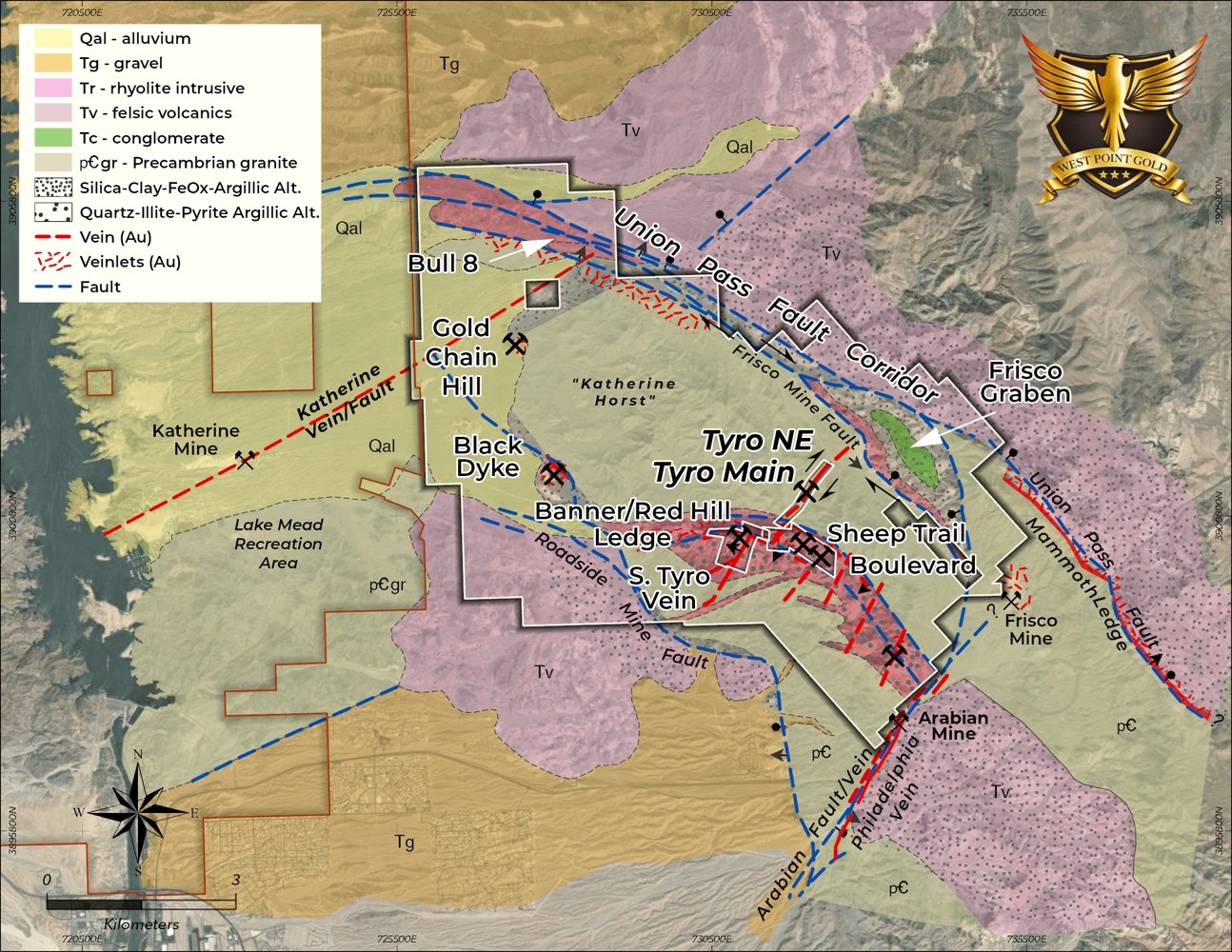
Vancouver, British Columbia–(Newsfile Corp. – September 9, 2026) – West Point Gold Corp. (TSXV: WPG) (OTCQX: WPGCF) (FSE: LRA0) (“West Point Gold” or the “Company”) is pleased to announce that it plans to start the next phase of drilling at the Gold Chain project in Arizona this month. The program will combine reverse circulation (“RC”) and core drilling for a total of 30,000m. The focus of the drill program is to expand both the high-grade NE Tyro and Tyro Main zones to depth and along strike. Additional targets are expected to include Black Dyke, Sheep Trail, Bull 8 and the Frisco Graben.
“Gold Chain is approaching a key milestone with its maiden resource, and this 30,000m program is designed to build on that foundation. The goal is to expand the high-grade NE Tyro deeper below 66.2 m at 6.57 g/t Au (GC26-148) while advancing Black Dyke, Sheep Trail, and the district-scale Frisco Graben target. Each represents an opportunity to grow the resource base beyond the upcoming initial estimate, which will only be based on the 20,696m drilled to date at Tyro,” stated Derek Macpherson, President & CEO.
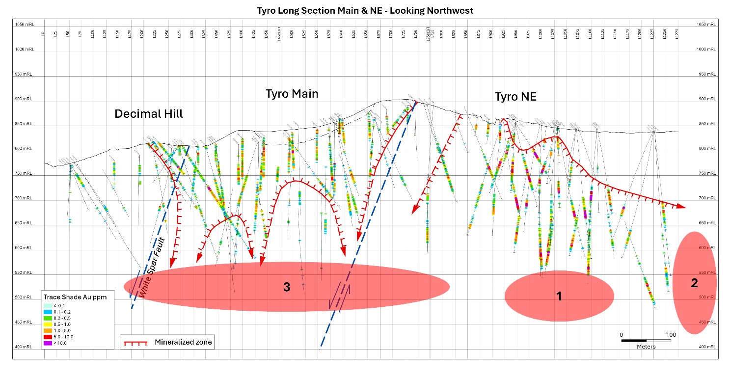
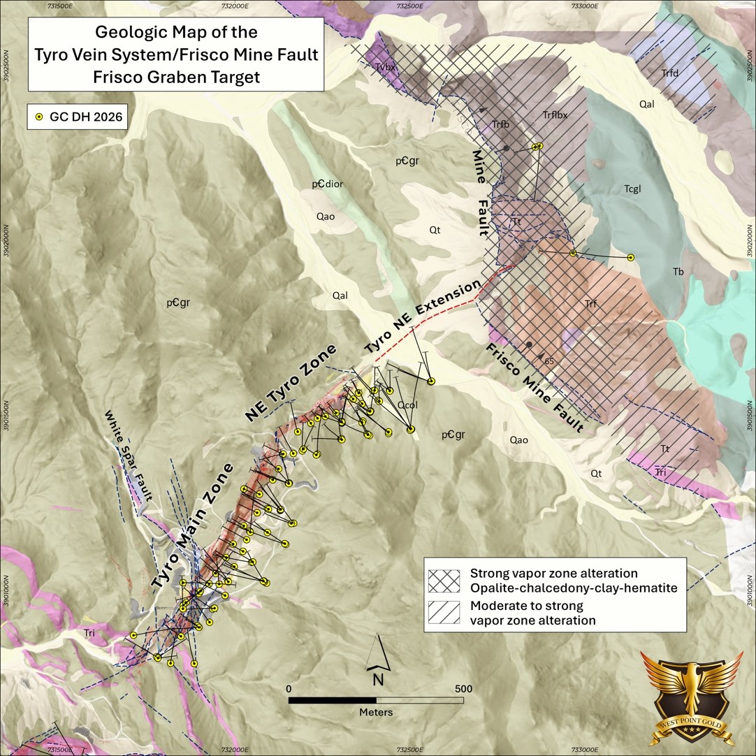
Northeast (“NE”) Tyro The best drill results at the Gold Chain project to date have been from NE Tyro. This shallow zone has returned significant grades and widths. Drilling in 2026 materially expanded this zone along strike and at depth, providing critical mass for the pending maiden resource. The next drilling phase at this zone will focus on pushing gold mineralization deeper and below some of the final high-grade holes from the most recent drill program (Target Area 1 – Figure 2). Additionally, the zone remains open to the northeast towards the Frisco Mine fault, the southwest boundary of the Frisco Graben target. West Point Gold believes that the Frisco Mine fault may serve as a regional conduit for mineralizing fluids, and moving toward the fault and downwards along the footwall is very prospective. Figure 2 shows the target areas at NE Tyro (Target Area 2). The amount of drilling at NE Tyro will be dependent on results.
Tyro Main Zone Tyro Main is also expected to contribute materially to the maiden resource. Recent drilling at the Tyro Main Zone demonstrated weakening gold grades to depth; however, the alteration in those drill holes appears to more closely resemble what one would typically see above a low sulphidation epithermal gold zone, not below. As such, the plan is to continue testing the Tyro Main zone to depth (Target Area 3 – Figure 2) using two strategies: first, stepping down below the 2026 intercepts; and second, pushing the limits of Target Area 1 to the southwest and beneath the current Tyro Main mineralized zone.
Figure 2: Tyro Long Section showing drill hole traces and intercepts. Also shown are the generalized targets (#1 – #3) in order of priority for the upcoming drilling campaign.
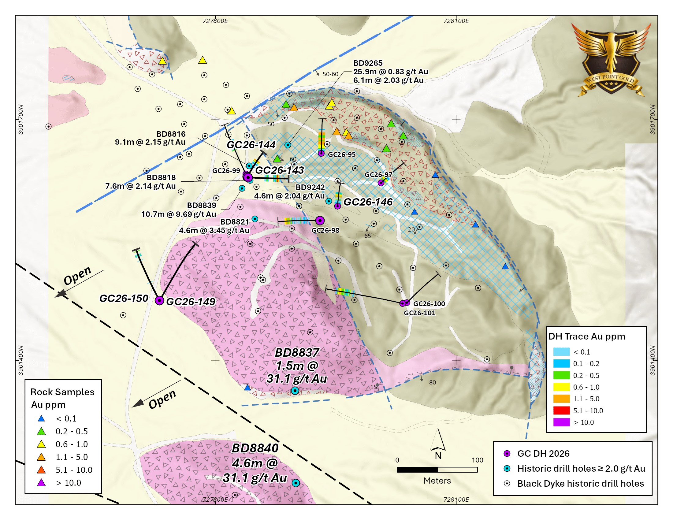
Black Dyke Target Black Dyke has evolved from a historical prospect into a credible second potential resource-development area at Gold Chain but will not be included in the maiden resource. Its shallow, low-angle geometry, along with its oxidized nature, could make it particularly attractive for potential open-pit development if additional drilling establishes sufficient scale and continuity. The zone is located approximately 4km west of the Tyro Main Zone along the Roadside Mine fault, which borders the southwest flank of the Katherine Horst. Alteration and vein textures observed in the shallow drilling suggest additional potential exists at depth, which has been supported by recently acquired historical drilling data.
Initial RC drilling has defined a shallow-dipping zone extending for at least 200m along strike and approximately 250m down-dip. Importantly, mineralization begins at or near surface, is largely oxidized, and remains open to the west and down-dip to the southwest. Initial drilling returned encouraging, relatively consistent widths and grades, highlighted by 36.6 m at 1.04 g/t Au (GC26-095) from surface, 21.3 m at 0.92 g/t Au (GC26-098), 7.6 m at 1.56 g/t Au (GC26-099), and 12.2 m at 1.09 g/t Au (GC26-101).
Drilling is planned to follow up on the high-grade historical results and continue expanding the zone towards the Roadside Mine fault.
Figure 3: Geologic Map of the Black Dyke prospect showing historical and 2026 (purple) drill holes along with surface samples. Please note historical holes BD8837 and BD8840 with 1.5 to 4.6m of >1 opt Au.
Sheep Trail Sheep Trail was the highest grade mine in the Katherine (North Oatman) District when it was last mined over 100 years ago. Recent drill results suggest that it is a third potential resource-development area at Gold Chain. Located approximately 600 metres south of the Tyro Main Zone, drilling at Sheep Trail has intersected broad zones of shallow gold mineralization within an extensive structural corridor that can be traced for more than one kilometre. Recent drilling has returned encouraging near-surface intersections, including 32.0 metres grading 1.05 g/t Au from only 9.1 metres depth (GC26-106), 19.8 metres grading 1.42 g/t Au from 51.8 metres (GC26-111), and 7.6 metres grading 2.41 g/t Au from 61.0 metres (GC26-113).
Importantly, mineralization remains open along strike, providing an opportunity to expand the system through additional drilling. Continued drilling will focus on expanding the known mineralized zones, testing extensions along the broader Banner-Sheep Trail trend and evaluating the potential for Sheep Trail to contribute meaningful additional ounces to the Gold Chain resource base.
Bull 8 Target Bull 8 is an early-stage gold discovery located approximately 6 km northwest of the Tyro Zone. The prospect occurs along the northwest-trending Union Pass Fault Corridor characterized by strongly sheared, brecciated and altered Precambrian granite cut by fault-bounded dikes. Historical pits, adits and trenches occur throughout the prospect, with surface samples returning up to 2.09 g/t Au. Widespread quartz veining, hydrothermal alteration and anomalous gold occur along the broader Union Pass Fault Corridor, which extends for roughly 12 km across the property. The fault corridor is interpreted as a major pre-, intra- and post-mineral structural control on the broader Gold Chain mineralizing system. The 2026 drilling consisted of six RC holes totalling 856 m, with gold mineralization intersected in every hole. The standout result was GC26-136: 21.4 m at 1.01 g/t Au, including an estimated 18 m true width, beginning at 71.6 m depth. A second hole, GC26-130, returned 12.2 m at 0.41 g/t Au from only 6.1 m depth, demonstrating that mineralization also occurs close to surface.
Drilling is expected to follow up on the 2026 results and expand the zone to depth and along strike.
Frisco Graben The Frisco Graben represents one of the largest and most compelling discovery opportunities at the Gold Chain Project. Located immediately northeast of the high-grade Northeast Tyro zone, Frisco Graben is a large-scale, concealed low-sulphidation epithermal gold target extending approximately four kilometres in length and up to 750m in width. The target lies at the intersection of the northeast extension of the mineralized Tyro structural corridor and the regionally significant northwest-trending Frisco Mine Fault, creating a highly prospective structural setting for the development of a substantial gold system (Figure 4).
Exploration at Frisco has identified widespread, intense hydrothermal alteration associated with rhyolite dikes, flow domes, volcanic rocks, and major graben-bounding structures. Initial drilling encountered broad zones of deeply oxidized kaolinite-silica-hematite alteration in the hanging wall of the Frisco Mine fault. Prior drilling intersected anomalous gold and elevated mercury, an important pathfinder element in low-sulphidation epithermal systems. Hyperspectral and geochemical studies indicate that the initial drill holes remained within the upper, steam-heated portion of the hydrothermal system, suggesting that the prospective gold-bearing boiling zone may occur deeper and remains largely untested.
Drilling conducted in 2026 at NE Tyro reveals that gold mineralization is extending toward and plunging into the footwall of the Frisco Mine fault. This provides West Point Gold the opportunity to follow mineralization into and beneath the Frisco Graben domain. Recognizing the complex structural and hydrothermal history at Gold Chain, determining the relationship between gold mineralization in the footwall and steam-generated alteration in the hanging wall of the Frisco Mine fault is an important objective in the 2026-2027 drilling campaign.
Figure 4: Geologic Map of the intersection of the Tyro Vein System and the Frisco Mine fault revealing the spatial relation between gold mineralization and steam-generated alteration of the Frisco Graben target area
Approval of Deferred Share Unit and Restricted Share Unit Plan The Company also announces that, on August 20, 2026, disinterested shareholders of the Company approved the adoption of its deferred share unit and restricted share unit plan (the “DSU/RSU Plan”). The DSU/RSU Plan is intended to attract, retain, and motivate key individuals to provide services to the Company. The DSU/RSU Plan permits a maximum of 13,708,176 common shares in the capital of the Company that may be issued to eligible participants under the DSU/RSU Plan, subject to adjustment as provided for in the DSU/RSU Plan. Please refer to the Company’s management information circular dated July 21, 2026, available on SEDAR+ under the Company’s profile, for a copy and summary of the DSU/RSU Plan.
Equedia Marketing Agreement West Point Gold has engaged Equedia Network Corp., an arm’s-length service provider, to provide communications and advisory services in accordance with TSX Venture Exchange policies and applicable securities laws.
Based in Richmond, B.C., Equedia specializes in marketing, communications, media engagement and public awareness services within the mining and metals sector. Under a media and investor relations services agreement dated September 8, 2026, Equedia will provide communications, marketing and advisory services to the company for a three-month term for a one-time fee of $500,000, plus applicable taxes payable at the commencement of services.
The company will not issue any securities to Equedia as compensation for its marketing services. As of the date hereof, to the Company’s knowledge, Equedia (including its directors and officers) does not own any securities of the Company.
The marketing agreement with Equedia is subject to TSX Venture Exchange approval.
Qualified Person Robert Johansing, M.Sc. Econ. Geol., P. Geo., the Company’s Vice President, Exploration, is a qualified person (“QP”) as defined by NI 43-101 and has reviewed and approved the technical content of this press release. Mr. Johansing has also been responsible for overseeing all phases of the drilling program, including logging, labelling, bagging and transport from the project to American Assay Laboratories of Sparks, Nevada. Drillholes have a diameter of about 10cm, and samples have an approximate weight of 5 to 10kg. Samples were then dried, crushed and split, and pulp samples were prepared for analysis. Gold was determined by fire assay with an ICP finish, and over-limit samples were determined by fire assay and gravimetric finish. Silver plus 15 other elements were determined by Aqua Regia ICP-AES (IM-2A16), and over-limit samples were determined by fire assay and gravimetric finish. Both certified standards and blanks were inserted on site along with duplicates, standards and blanks inserted by American Assay. The results summarized above have been carefully reviewed with reference to the QA/QC results. Standard sample chain of custody procedures were employed during drilling and sampling campaigns until delivery to the analytical facility.
The QP has not completed sufficient work to verify the historical information received on the Black Dyke, Bull 8 and Gold Chain Hill targets, particularly with regard to historical drill results. However, the QP believes that prior drilling and analytical results were completed to industry standard practices at the time they were drilled.
About West Point Gold Corp. West Point Gold is an exploration and development company focused on unlocking value across four strategically located projects along the prolific Walker Lane Trend in Nevada and Arizona, USA, providing shareholders with exposure to multiple discovery opportunities across one of North America’s most productive gold regions. The Company’s near-term priority is advancing its flagship Gold Chain Project in Arizona.
For further information regarding this press release, please contact: Aaron Paterson, Corporate Communications Manager Phone: +1 (778) 358-6173 Email: info@westpointgold.com
FORWARD-LOOKING STATEMENTS: Certain statements contained in this press release constitute forward-looking information. These statements relate to future events or future performance. Forward-looking statements include estimates and statements that describe the Company’s future plans, objectives or goals, including words to the effect that the Company or management expects a stated condition or result to occur. The use of any of the words “could”, “intend”, “expect”, “believe”, “will”, “projected”, “estimated” and similar expressions and statements relating to matters that are not historical facts are intended to identify forward-looking information and are based on the Company’s current belief or assumptions as to the outcome and timing of such future events including, among others, assumptions about future prices of gold, silver, and other metal prices, currency exchange rates and interest rates, timing of the Company’s maiden resource estimate, favourable operating conditions, political stability, obtaining government approvals and financing on time, obtaining renewals for existing licenses and permits and obtaining required licenses and permits, labour stability, stability in market conditions, availability of equipment, availability of drill rigs, and anticipated costs and expenditures. The Company cautions that all forward-looking statements are inherently uncertain, and that actual performance may be affected by a number of material factors, many of which are beyond the Company’s control. Such factors include, among other things: risks and uncertainties relating to West Point Gold’s ability to complete any payments or expenditures required under the Company’s various option agreements for its projects; and other risks and uncertainties relating to the actual results of current exploration activities, the uncertainties related to resources estimates; the uncertainty of estimates and projections in relation to production, costs and expenses; risks relating to grade and continuity of mineral deposits; the uncertainties involved in interpreting drill results and other exploration data; the potential for delays in exploration or development activities; uncertainty related to the geology, grade and continuity of mineral deposits; the possibility that future exploration, development or mining results may vary from those expected; statements about expected results of operations, royalties, cash flows, financial position may not be consistent with the Company’s expectations due to accidents, equipment breakdowns, title and permitting matters, labour disputes or other unanticipated difficulties with or interruptions in operations, fluctuating metal prices, unanticipated costs and expenses, uncertainties relating to the availability and costs of financing needed in the future and regulatory restrictions, including environmental regulatory restrictions. The possibility that future exploration, development or mining results will not be consistent with adjacent properties and the Company’s expectations; operational risks and hazards inherent with the business of mining (including environmental accidents and hazards, industrial accidents, equipment breakdown, unusual or unexpected geological or structural formations, cave-ins, flooding and severe weather); metal price fluctuations; environmental and regulatory requirements; availability of permits, failure to convert estimated mineral resources to reserves; the inability to complete a feasibility study which recommends a production decision; the preliminary nature of metallurgical test results; fluctuating gold prices; possibility of equipment breakdowns and delays, exploration cost overruns, availability of capital and financing, general economic, political risks, market or business conditions, regulatory changes, timeliness of government or regulatory approvals and other risks involved in the mineral exploration and development industry, and those risks set out in the filings on SEDAR+ made by the Company with securities regulators. Although the Company believes that the assumptions and factors used in preparing the forward-looking information in this corporate press release are reasonable, undue reliance should not be placed on such information, which only applies as of the date of this news release, and no assurance can be given that such events will occur in the disclosed time frames or at all. The Company expressly disclaims any intention or obligation to update or revise any forward-looking statements whether as a result of new information, future events or otherwise, other than as required by applicable securities legislation.
Neither the TSX Venture Exchange nor its Regulation Services Provider (as that term is defined in the policies of the TSX Venture Exchange) accepts responsibility for the adequacy or accuracy of this release.
Denver, Colorado–(Newsfile Corp. – September 8, 2026) – Elemental Royalty Corporation (NASDAQ: ELE) (TSX: ELE) (“Elemental” or “the Company“) is pleased to announce the receipt of the clearance decision from Mexico’s Antitrust agency, the Comisión Nacional Antimonopolio (“CNA“) with respect to the Company’s acquisition of Vizsla Royalties Corp. (TSXV: VROY) (OTCQX: VROY) (“Vizsla Royalties“) (the “Transaction“).
The Transaction provides Elemental with exposure to Vizsla Royalties’ 2.0% to 3.5% net smelter returns royalties (the “Panuco Royalties“) on Vizsla Silver Corp.’s Panuco silver-gold project in Mexico. The Panuco Royalties will be cornerstone assets in the Elemental portfolio and are life-of-mine interests with no caps, buybacks or step-downs, covering the entire existing resources at Panuco.
Elemental Chief Executive, David M. Cole, commented: “Receiving Antitrust approval is the final regulatory milestone needed to complete the acquisition of Vizsla Royalties, and we look forward to announcing the closing of the Transaction soon.”
Next Steps and Timing Subject to the satisfaction or waiver of all conditions precedent to the Arrangement, the Transaction is anticipated to be completed shortly.
Further details of the Transaction are set out in the Arrangement Agreement dated May 13, 2026, and the management information circular of Vizsla Royalties prepared in connection with the Transaction, each of which is available under Vizsla Royalties’ profile on SEDAR+ at www.sedarplus.ca.
Technical Disclosure and Qualified Person The scientific and technical information contained in this news release has been reviewed and approved by Michael Sheehan, an employee of the Company and a “Qualified Person” as defined in NI 43-101.
NASDAQ: ELE | TSX: ELE | ISIN: CA28620K1066 | CUSIP: 28620K
About Elemental Royalty Corporation. Elemental Royalty is a new mid-tier, gold-focused streaming and royalty company with a globally diversified portfolio of 18 producing assets and more than 200 royalties, anchored by cornerstone assets and operated by world-class mining partners. Formed through the merger of Elemental Altus and EMX, the Company combines Elemental Altus’s track record of accretive royalty acquisitions with EMX’s strengths in royalty generation and disciplined growth. This complementary strategy delivers both immediate cash flow and long-term value creation, supported by a best-in-class asset base, diversified production, and sector-leading management expertise.
Elemental Royalty trades on NASDAQ and on the TSX under the ticker symbol “ELE”.
Cautionary note regarding forward-looking statements and financial outlook This news release contains certain “forward looking statements” and certain “forward-looking information” as defined under applicable United States and Canadian securities laws. Forward-looking statements and information can generally be identified by the use of forward-looking terminology such as “may”, “will”, “should”, “expect”, “intend”, “estimate”, “anticipate”, “believe”, “continue”, “plans” or similar terminology (including negative and grammatical variations thereof).
Forward-looking statements and information include, but are not limited to, statements regarding future royalties and future consideration payments or issuances of shares, or other statements that are not statements of fact. Forward-looking statements and information are based on forecasts of future results, estimates of amounts not yet determinable and assumptions that, while believed by management to be reasonable, are inherently subject to significant business, economic and competitive uncertainties and contingencies.
Forward-looking statements and information are subject to various known and unknown risks and uncertainties, many of which are beyond the ability of Elemental to control or predict, that may cause Elemental’s actual results, performance or achievements to be materially different from those expressed or implied thereby, and are developed based on assumptions about such risks, uncertainties and other factors set out herein, including but not limited to: the impact of general business and economic conditions, the absence of control over the mining operations from which Elemental will receive royalties, risks related to international operations, government relations and environmental regulation, the inherent risks involved in the exploration and development of mineral properties; the uncertainties involved in interpreting exploration data; the potential for delays in exploration or development activities; the geology, grade and continuity of mineral deposits; the possibility that future exploration, development or mining results will not be consistent with Elemental’s expectations; accidents, equipment breakdowns, title matters, labour disputes or other unanticipated difficulties or interruptions in operations; fluctuating metal prices; unanticipated costs and expenses; uncertainties relating to the availability and costs of financing needed in the future; the inherent uncertainty of production and cost estimates and the potential for unexpected costs and expenses, commodity price fluctuations; currency fluctuations; regulatory restrictions, including environmental regulatory restrictions; liability, competition, loss of key employees and other related risks and uncertainties. For a discussion of important factors which could cause actual results to differ from forward-looking statements, refer to the annual information form of Elemental for the year ended December 31, 2025. Elemental undertakes no obligation to update forward-looking statements and information except as required by applicable law. Such forward-looking statements and information represent management’s best judgment based on information currently available. No forward-looking statement or information can be guaranteed, and actual future results may vary materially. Accordingly, readers are advised not to place undue reliance on forward-looking statements or information.
Neither the Nasdaq Stock Market LLC, or the TSX, or its Regulation Service Provider (as that term is defined in the policies of the TSX) accepts responsibility for the adequacy or accuracy of this press release.
Edmonton, Alberta–(Newsfile Corp. – September 8, 2026) – Grizzly Discoveries Inc. (TSXV: GZD) (FSE: G6H) (OTCQB: GZDIF) (“Grizzly” or the “Company”) is pleased to announce that preliminary results for a Phase 2 sampling program conducted in June 2026 to follow up trenching conducted at the Midway Precious Metals and Critical Minerals Target and Induced Polarization (“IP”) chargeability results at the Sappho Critical Minerals Target (Figure 1).
Highlights
Significant Gold and Silver from chip samples in a trench extending the Main Midway Mine trend with up to 22.8 grams per tonne (g/t or ppm) gold (Au) and up to 1,120 g/t silver (Ag) (Figures 2 and 3; Table 1).
Additional samples in trenches immediately east of the Main Midway Mine with up to 1.7 g/t Au and to the southwest with up to 2.7 g/t Au. Drilling is set to test these anomalous samples and the historical Midway Mine this fall, 2026 (Figures 2 and 3; Table 1).
The Midway area is a window into the Paleozoic – Triassic rocks through the Toroda Graben and Tertiary volcanics that fill the graben.
Follow up sampling in the vicinity of the Sappho Chargeability Anomaly identified in early to mid 2026 (See Company News Release dated July 6, 2026) has yielded 4.73 g/t Au from quartz float at the headwaters of Norwegian Creek but coincident with the northeast edge of the anomaly (Figure 4).
Host rocks in the area are mapped as late Paleozoic to Early Triassic metasedimentary rocks including carbonates and calcareous shales. A number of dykes, stocks and large intrusions are mapped in the area and likely range from Jurassic to Cretaceous to Eocene in age.
The Geological Setting is the East Fault Contact of the Toroda Graben with numerous pyroxenite-monzonite-diorite (older – Jurassic) and younger quartz-feldspar porphyry (QFP)-diorite (Tertiary) intrusions into the sedimentary package and the overlying younger intermediate-mafic volcanics.
The East and West Faults of the Toroda Graben likely played a role in controlling the Au-Ag mineralization for the Buckhorn Skarn and Mine to the southwest and the Cu-Au-Ag mineralization for the Motherlode/Greyhound skarns in the Greenwood area (Figure 1).
Permitting of drill locations to test the Sappho Chargeability Anomaly is underway. The Company is planning to complete an initial drill test this fall, 2026.
The Company is currently in the process of permitting additional drillhole pads to complete drill testing of a number of the chargeability targets during a fall drilling program at the Motherlode Critical Minerals Target area along with potentially the Sappho Critical Minerals Target area and the Midway Precious Metals – Critical Minerals Target area. Further IP work, geological mapping and surface sampling centered on several of the targets is planned prior to the commencement of drilling.
Brian “Griz” Testo, President & CEO of Grizzly Discoveries, states: “Trenching during June 2026 has extended the known surface extent of the Main Midway vein structure and mineralization pictured in Figure 3. New samples have yielded significant gold and silver and the Grizzly team is excited to see what drilling might show us at both the historical Midway Mine and the Sappho Chargeability Target – we will continue to refine these targets to the drill ready stage for drilling in the next couple of months and look forward to identifying and presenting some new discoveries for the shareholders of Grizzly.”
Table 1: Midway Mine and Sappho Rock Sampling 2026 – Summary Results.
The 2026 exploration work was suspended in July and August during high fire season but has recommenced and will be ongoing through the fall and includes prospecting and rock sampling at targets in the Motherlode area, the Rock Creek area, the Midway area, the Copper Mountain area, the Overlander-Attwood area and at the Sappho area (Figure 1). Additional groundwork including ground geophysical surveys are being planned and will comprise IP, magnetics and Loupe electromagnetics (EM) for the Sappho, the Midway and Motherlode areas (Figure 1). Additional drilling is planned from October to December. Results as they become available from the 2026 work will be released as they are received.
Figure 4: Sappho Chargeability Anomaly Plan View – Recent Rock Sample Results.
At Midway, selective rock grab and composite rock grab samples collected during 2022 from outcrop at the Midway Mine-Picturestone area, yielded a range of 12.05 g/t or 0.351 ounces per ton (opt) Au up to 70.8 g/t (2.065 opt) Au (See Company news release dated October17, 2022 and Figure 5 below).
Three (3) of the 7 selective rock grab samples from the Midway Mine yielded from 1,360 g/t Ag (39.7 opt) up to 2,140 g/t Ag (62.4 opt) (see Company news release dated October 17, 2022).
Two new showings identified in 2023 near the historical Midway Mine including up to 5.64 g/t Au (0.165 opt) from a showing 400 m to the north of Midway and up to 4.19 g/t Au (0.122 opt) from a grab sample collected about 375 m to the west of the Midway Mine.
At least 6 new areas with anomalous gold (> 100 ppb), copper (>200 ppm) and silver in soils have been identified at Midway in work conducted between 2022 and 2024.
The Midway area is being targeted for copper-gold skarn and epithermal gold-silver.
All highly anomalous samples are from outcrop and characterized by the presence of abundant pyrite, arsenopyrite with visible galena and sphalerite in a siliceous chalcedonic host. The mineralization is hosted in polymetallic veins that display the presence of Pb, Zn, Cu, arsenic (As) and antimony (Sb) and are likely epithermal in nature.
A selective rock grab sample from outcrop 200 m west of the main Midway Mine yielded 15.85 g/t Au (0.462 opt) and 1,530 g/t Ag (44.6 opt), illustrating that there is potential for additional high-grade mineralization in the area.
Figure 5: Midway geology and showings with gold in soils and rocks.
The analytical work on the Greenwood Critical Minerals Project was performed by the ALS Global Limited in Kamloops and North Vancouver, an internationally recognized analytical service provider. All core and rock samples were prepared using ALS procedure PREP-31A (dry, crush to 70% passing 2mm, riffle split off 250g, pulverize split to better than 85% passing 75 microns) and analyzed by method PGM-ICP27 (30g fire assay with ICP finish for Au, Pt and Pd) and ME-ICP61a (0.5g, four acid digestion and ICP-AES/MS analysis) for multi-elements. Any samples containing >10g/t Au are reanalyzed using method FAS-415 (30g Fire Assay with gravimetric finish). Samples containing >100 ppm Ag and/or >1% Cu, Pb, & Zn are reanalyzed using method ICF-6 (0.2g, 4-acid digest and ore grade ICP-AES analysis). Rock samples were analyzed using Au-ICP21 (30g fire assay with ICP-AES finish) and multi-elements using ME-ICP41 (0.5g, aqua regia digestion and ICP-AES analysis).
The reported work has been completed using industry standard procedures, including a quality assurance/quality control (“QA/QC”) program consisting of the insertion of certified standards, blanks and duplicates into the sample stream by APEX personnel. The ALS geochemical laboratory data was provided directly to APEX and the QP and has been verified by the QP.
QUALIFIED PERSON STATEMENT
The technical content of this news release and the Company’s technical disclosure has been reviewed and approved by Michael B. Dufresne, M. Sc., P. Geol., P.Geo., who is a non-independent Qualified Person as defined by National Instrument 43-101 Standards of Disclosure for Mineral Projects.
ABOUT GRIZZLY DISCOVERIES INC.
Grizzly is a diversified Canadian mineral exploration company with its primary listing on the TSX Venture Exchange focused on developing its approximately 72,700 ha (approximately 180,000 acres) of precious and critical minerals properties in southeastern British Columbia. Grizzly is run by a highly experienced junior resource sector management team, who have a track record of advancing exploration projects from early exploration stage through to feasibility stage.
On behalf of the Board,
GRIZZLY DISCOVERIES INC. Brian Testo, CEO, President
Suite 363-9768 170 Street NW Edmonton, Alberta T5T 5L4
Neither the TSX Venture Exchange nor its Regulation Services Provider (as that term is defined in the policies of the TSX Venture Exchange) accepts responsibility for the adequacy or accuracy of this release.
Caution concerning forward-looking information
This press release contains “forward-looking information” and “forward-looking statements” within the meaning of applicable securities laws. This information and statements address future activities, events, plans, developments and projections. All statements, other than statements of historical fact, constitute forward-looking statements or forward-looking information. Such forward-looking information and statements are frequently identified by words such as “may,” “will,” “should,” “anticipate,” “plan,” “expect,” “believe,” “estimate,” “intend” and similar terminology, and reflect assumptions, estimates, opinions and analysis made by management of Grizzly in light of its experience, current conditions, expectations of future developments and other factors which it believes to be reasonable and relevant. Forward-looking information and statements involve known and unknown risks and uncertainties that may cause Grizzly’s actual results, performance and achievements to differ materially from those expressed or implied by the forward-looking information and statements and accordingly, undue reliance should not be placed thereon.
Risks and uncertainties that may cause actual results to vary include but are not limited to the availability of financing; fluctuations in commodity prices; changes to and compliance with applicable laws and regulations, including environmental laws and obtaining requisite permits; political, economic and other risks; as well as other risks and uncertainties which are more fully described in our annual and quarterly Management’s Discussion and Analysis and in other filings made by us with Canadian securities regulatory authorities and available at www.sedarplus.ca. Grizzly disclaims any obligation to update or revise any forward-looking information or statements except as may be required by law.
Coyote Copper Mines (TSXV:CCMM) is advancing an ambitious exploration programme at its Copper Springs property, with recent geophysical work, surface mineralisation and a newly identified zone pointing towards the potential for a much larger copper system at depth.
For copper explorers, one of the most important questions is whether a known historic resource represents the full extent of mineralisation, or simply the beginning of something considerably larger.
At Coyote Copper Mines, the company believes Copper Springs could offer that kind of potential.
The exploration opportunity has also attracted attention from Optimo Research, which has highlighted the combination of Copper Springs’ historic copper resource, the newly identified zone and the large geophysical anomalies across the property. The research points to the potential significance of the upcoming exploration programme, particularly as drilling begins to test whether the mineralisation identified at surface forms part of a much larger porphyry copper system at depth.
Read the full Optimo Research report here
With extensive geophysical surveys completed across the property and an active field programme underway, the company is now preparing for drilling designed to test both shallow mineralisation and deeper targets that could reveal the scale of the underlying system.
Speaking about the project, Dan Weir, CEO of Coyote Copper Mines, highlighted the significant amount of exploration work already being undertaken at Copper Springs, including magnetotelluric (MT) and spectral induced polarisation (SIP) surveys.
“We’re currently having every single day about 11 geologists and labourers out working on the property,” Weir explained, underlining the level of activity currently taking place on the ground.
Geophysics points to significant exploration potential
The company’s exploration programme has generated a number of large geophysical anomalies across the property, providing targets for the next phase of drilling.
According to Weir, the results have increased the company’s interest in the potential for a substantial porphyry copper system beneath Copper Springs.
The upcoming drilling programme is therefore expected to play an important role in testing the company’s geological model, with a combination of shallow and deeper holes planned.
The objective is to establish whether the mineralisation identified at surface continues into a larger system at depth.
For investors, this represents an important potential catalyst: successful drilling could provide the geological evidence needed to demonstrate that Copper Springs extends well beyond its historic resource footprint.
Newly identified zone adds another layer of upside
Adding to the exploration story is a newly identified zone containing surface copper-molybdenum sulphides and magmatic breccias.
The presence of these features is particularly interesting because they may represent part of a broader mineralised system extending below surface.
Rather than being confined to a shallow mineralised occurrence, the company believes the surface indications could potentially be associated with a much larger sulphide system at depth.
This is where the forthcoming deep drilling programme becomes particularly significant.
The first deep holes will provide an opportunity to test the company’s interpretation of the geophysical data and determine whether the anomalies correspond to substantial copper mineralisation.
Location provides an important geological reference point
Coyote Copper’s exploration thesis is also supported by the property’s proximity to one of the world’s most significant undeveloped copper projects.
Copper Springs is adjacent to the Resolution Copper project in Arizona, a major development being advanced by Rio Tinto and BHP.
Resolution is a very large, deep-seated copper deposit, providing an important geological reference point for the region.
Weir pointed to the depth and scale of Resolution when discussing the potential significance of Coyote Copper’s geophysical results, noting that some of the company’s work indicates the possibility of a similarly substantial system at depth.
While exploration results at Copper Springs will ultimately determine the property’s potential, the geological setting provides an intriguing backdrop for the company’s current programme.
Copper at surface could be a major advantage
One of the aspects of Copper Springs that particularly stands out is the presence of sulphide mineralisation at surface.
Weir contrasted this with the considerable depth at which mineralisation occurs at Resolution.
For Coyote Copper, the combination of surface mineralisation and deep geophysical anomalies creates an exploration model that the company believes warrants systematic testing.
The key question now is whether the surface expressions, newly identified zone and geophysical anomalies are all connected to a larger porphyry copper system.
Drilling will be critical in answering that question.
Drilling could define the next phase of the story
With field teams active on the property and geophysical work helping to identify priority targets, Coyote Copper is moving towards a potentially important exploration phase.
The company intends to use both shallow and deeper drilling to test the Copper Springs system from multiple angles.
For investors following the company, the forthcoming drill results could therefore provide a series of important milestones, from confirming the continuity of known mineralisation to potentially demonstrating the presence of a much larger copper system at depth.
The combination of a historic copper resource, newly identified surface mineralisation, extensive geophysical anomalies and a strategically interesting geological setting gives Copper Springs a compelling exploration proposition.
As Coyote Copper moves from target generation towards drilling, the focus will increasingly turn to what lies beneath the surface, and whether the company’s exploration model can unlock a significantly larger copper opportunity.
With exploration activity accelerating, Copper Springs is entering an important stage in its development, with drilling now set to test the scale and continuity of the mineralised system and potentially reshape the company’s growth story.