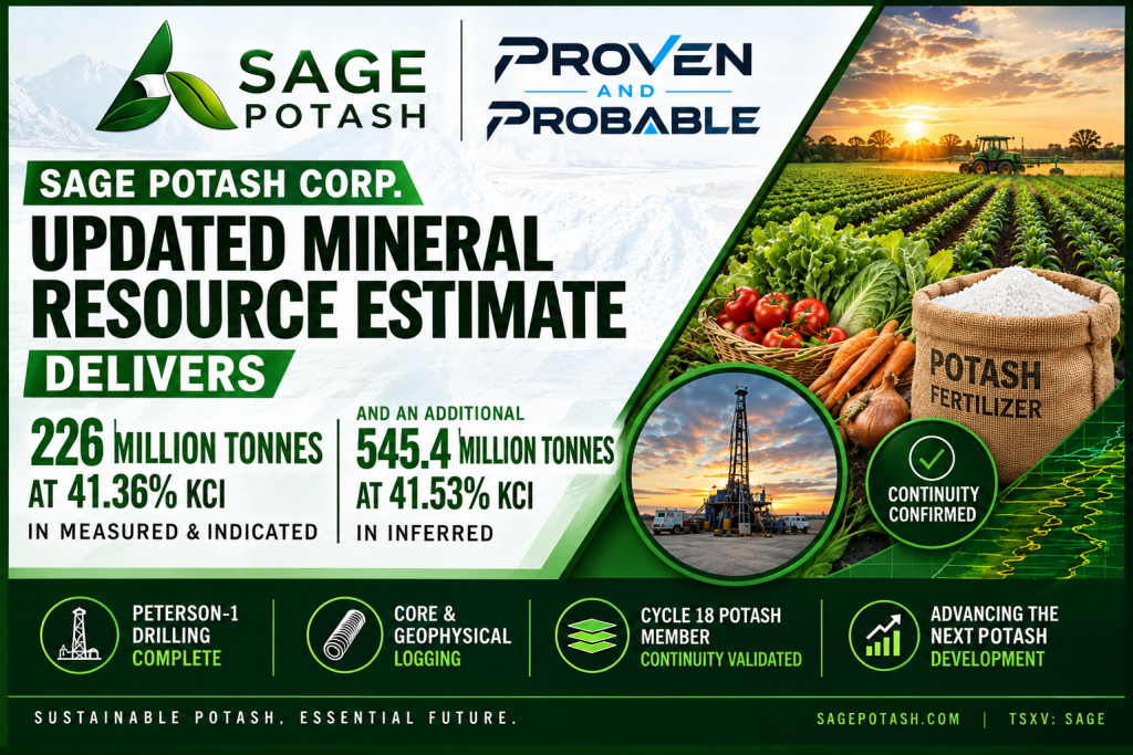
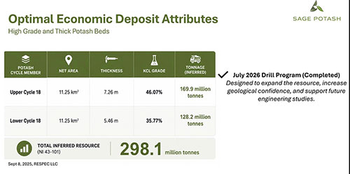
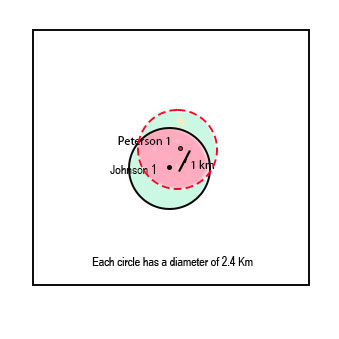
Vancouver, British Columbia and Salt Lake City, Utah–(Newsfile Corp. – October 19, 2026) – Sage Potash Corp. (TSXV: SAGE) (OTCQB: SGPTF) (“Sage Potash” or the “Company”) is pleased to announce a significant upgrade to its potash resource estimates after the successful completion of its Summer 2026 drill program at the Company’s flagship Sage Plain Potash Project in Utah’s Paradox Basin. The new Mineral Resource Estimate (“MRE”), as prepared by independent engineering firm RESPEC LLP, materially expands the inferred potash resource and allows the addition of measured and indicated resource categories.
Summary
Measured Potash Resource of 54.3 million tonnes grading 41.31% KCl.
Indicated Potash Resource of 171.8 million tonnes grading 41.37% KCl
Inferred Potash Resource of 545.4million tonnes grading 41.53% KCl
Executive Comment
“Completion of the Summer 2026 drilling of the Peterson 1 Well and the resulting Mineral Resource Estimate mark a major milestone for the Company,” said Pat Varas, CEO of Sage Potash. “The results validate the project’s extensive potash resources and confirm the Paradox Basin’s potential to support a scalable, high-quality potash operation. The upgraded estimate provides a strong foundation for our next core objective: completing a Pre-Feasibility Study to demonstrate the viability and economic metrics of the Sage Plain Potash Project. We will now focus on optimizing the mining and processing plans, including the potential to scale up the project substantially from the preliminary economic assessment reported in September 2025.”
Resource Estimate
The Summer 2026 drilling of the Peterson 1 Well delivered high-grade thick intervals of both the Upper and Lower Cycle 18 potash beds. The new data confirms consistent lateral continuity of potash horizons, confirmation of high-grades and impressive thicknesses for solution mining.
Table 1.0 – Sage Plain Project Resource Estimate
Cycle 18 Member
Classification
Area (km2)
Area with Exclusions (km2)8,9
Thickness (m)
Average KCl Grade (%11)
In-Place Sylvinite Tonnage (MMT)1,2,3,4
Average Carnallite Content (%)
Average Insoluble Content (%)
Upper 18
Measured
3.05
2.29
7.2
40.73
33.9
0.09
0.47
Lower 18
Measured
3.05
2.29
4.3
42.27
20.4
0.01
0.42
Total Measured5
54.3
Upper 18
Indicated
9.64
7.23
7.1
40.88
106.8
0.09
0.48
Lower 18
Indicated
9.64
7.23
4.3
42.17
65.0
0.01
0.42
Total Indicated6
171.8
Total Measure and Indicated
226.1
Upper 18
Inferred
30.56
22.92
7.1
41.17
336.9
0.09
0.48
Lower 18
Inferred
30.56
22.92
4.4
42.11
208.5
0.01
0.42
Total Inferred7,10
545.4
Total Resource
771.5
MMT = Million Metric Tonnes.
Density of Sylvinite = 2.07 tonnes/m3.
In-Place Sylvinite is based on Area x Thickness.
Gross Resource based on 100% extraction ratio and 0% plant loss.
Measured Resource radius of influence is 0-750m.
Indicated Resource radius of influence is 750 – 2,000 m.
Inferred Resource radius of influence is 2,000 – 4,000 m.
Exclusions or deductions for unknown seismic anomalies are 25% of the area as no 3D seismic has been completed
The following deductions are anticipated, but not yet applied: A) Mining Parameter deductions for extraction ratio and cavern or plan loss; B) Economic Cut-offs from a project specific analysis. The appropriate deductions values are anticipated as outputs from further studies.
Potash Bed Inferred Resource uses a 5% K2O cutoff to define the upper and lower contacts.
Average KCl Grades are the weighted average for the interval thickness based on core recovered and Gamma ray readings in instances of core removal for geomechanical testing or core losses (Johnson 1 hole Lower Bed only and eight 30 cm sections form Peterson 1 Well).
The upgraded resource estimate provides an overall 259% increase in tonnage compared to the resource estimate in the Preliminary Economic Assessment Technical Report (dated November6, 2025, with an effective date of September 8, 2025, and available on www.sedarplus.ca under the Company’s profile) as shown in Table 2.
Resource classifications and estimates have been determined by RESPEC LLC of Grand Junction Colorado. RESPEC is the Qualified Professional (QP) as required by National Instrument 43-101, Standards of Disclosure for Mineral Projects (“NI 43-101″). Mr. Erik Hemstad – Principal Consultant with RESPEC commented, “RESPEC has been involved with the Sage Plain Project for many years and is pleased to provide this mineral resource estimate. We are also pleased to provide ongoing input on geological interpretation and appropriate potash solution mining techniques for this basin in general and the Sage Plain Project specifically. The Sage Plain Project is located within the heart of the Paradox Basin and is showing very strong potential as a potash producer in Utah.”
Next Steps
The Company will publish and file on Sedar+ a Technical Report in accordance with the requirements of NI43-101 within 45 days of this news release. Thereafter, the next phases of work will include:
Advancement of solution-mining engineering and process design including determination of solution mining and plant throughput capacity
Continued environmental study work and permitting activities for the new throughput capacity design
Ongoing collaboration with regional stakeholders and local communities
Trade-off and availability studies for the provision of power, water and transportation logistics to the Sage Plain site.
The Company plans to summarize the above facets and demonstrate the financial viability of the project in a Pre-Feasibility Study.
Qualified Person
The scientific and technical information contained in this news release has been reviewed and approved by Eric Hemstad, PE, a Qualified Person as defined by NI 43-101. Mr. Hemstad is a Consulting PE at RESPEC Company, LLC and is independent of Sage Potash.
About Sage Potash Corp.
Sage Potash Corp. (TSXV: SAGE) (OTCQB: SGPTF) is dedicated to the development of its flagship Sage Plain Potash Project, located in the Paradox Basin, Utah. With a large and high-grade resource base, the Company is advancing toward its goal of establishing a secure and sustainable domestic potash production platform in the United States. Sage Potash is committed to food security, environmental stewardship, and creating value for shareholders and stakeholders alike.
Neither the TSX Venture Exchange nor its Regulation Services Provider (as that term is defined in the policies of the TSX Venture Exchange) accepts responsibility for the adequacy or accuracy of this release.
Forward-Looking Statements
This news release contains “forward-looking information” and “forward-looking statements” within the meaning of applicable securities legislation. The forward-looking statements herein are made as of the date of this news release only, and the Company does not assume any obligation to update or revise them to reflect new information, estimates or opinions, future events or results or otherwise, except as required by applicable law. Often, but not always, forward-looking statements can be identified by the use of words such as “plans”, “expects”, “is expected”, “budgets”, “scheduled”, “estimates”, “forecasts”, “predicts”, “projects”, “intends”, “targets”, “aims”, “anticipates” or “believes” or variations (including negative variations) of such words and phrases or may be identified by statements to the effect that certain actions “may”, “could”, “should”, “would”, “might” or “will” be taken, occur or be achieved. Forward-looking information in this news release includes, but is not limited to, statements with respect to future events or future performance of Sage Potash, including but not limited to: filing on Sedar+ within 45 days of the date hereof a technical report to support the contents of this news release; advancement of solution mining engineering and process design including determination of solution mining and plant throughput capacity; completing environmental study work and permitting activities for the new throughput capacity design; continuing ongoing collaboration with regional stakeholders and local communities; completion of trade-off and availability studies for the provision of power, water and transportation logistics to the Sage Plain site; completion of a Pre-Feasibility Study to demonstrate the viability and economic metrics of Sage Plain Potash Project; and establishing a secure and sustainable domestic potash production platform in the United States. Forward-looking statements and information are subject to various known and unknown risks and uncertainties, many of which are beyond the ability of the Company to control or predict, that may cause the Company’s actual results, performance or achievements to be materially different from those expressed or implied thereby, and are developed based on assumptions about such risks, uncertainties and other factors set out herein, including, but not limited to, the risk factors set out under the heading “Risk Factors and Uncertainties” in the Company’s Management’s Discussion & Analysis available for review under the Company’s profile at www.sedarplus.ca. Such forward-looking information represents management’s best judgement based on information currently available. No forward-looking statement can be guaranteed and actual future results may vary materially. Accordingly, readers are advised not to place undue reliance on forward-looking statements or information.
Toronto, Ontario–(Newsfile Corp. – October 16, 2026) – Coyote Copper Mines Inc. (TSXV: CCMM) (“Coyote Copper” or the “Company “) is pleased to announce that it has signed a drilling contract to commence drilling the first half of November.
Warrant Acceleration
As of October 15, 2026 at 4:00 pm the following Warrants were exercised
7,311,901 Warrants with an exercise price of $0.15 from a financing that was completed in July and August of 2025 were exercised.
10,622,351 Warrants with an exercise price of $0.20 from a financing that was completed in January and February of 2026 were exercised.
1,052,152 finder’s Warrants with an exercise price of $0.14 from a financing that was completed in January and February of 2026 were exercised.
The total amount received by the Company from the exercising of the Warrants was C$3,368,556.63
97.7% of the Warrants were exercised.
The money received from the Warrant exercise will help fund the ongoing and planned exploration program, and fund additional mining claims being staked and acquired.
Exploration Update
The previously announced geophysical programs will be completed shortly. Once completed and interpreted, the company shall release the results.
Soil and channel sampling continue, results will be disseminated prior to drilling.
Drill roads and pads are being built, all necessary permits are in hand.
Drilling to start the first half of November. The drill slated for our program is finishing up another company’s project, so the exact date for our drilling to start is not known yet.
Dan Weir, CEO of Coyote Copper Mines Inc., stated: “We are very excited to see the drilling begin in approximately 20 to 30 days. The geophysics programs are yielding great results. We completed a site visit at the end of November which 35 people attended including 4 geologists from major mining and fund companies and numerous investors. Having 97.75% of the Warrants exercised, shows that our investors believe in the company, and the work we are doing. I would like to acknowledge all the amazing work that our geologists and geophysical contractors are completing. The large mining companies that have visited the project, have positively commented on the professional work.”
Qualified Person Michael N. Feinstein, PhD, CPG, is a “Qualified Person” under National Instrument 43-101 – Standards of Disclosure for Mineral Projects, and he has reviewed and approved the scientific and technical disclosure contained in this press release. Mr. Feinstein is independent of the Company.
For more information, please contact: Dan Weir CEO, Coyote Copper Mines Inc. DanWeir@CoyoteCopper.com Tel: +1-416-720-0754
Neither the Exchange nor its Regulation Services Provider (as that term is defined in the policies of the Exchange) accepts responsibility for the adequacy or accuracy of this release.
This news release does not constitute an offer to sell or a solicitation of an offer to buy any of the securities in the United States. The securities of the Company have not been and are not expected to be registered under the United States Securities Act of 1933, as amended (the “U.S. Securities Act“), or any state securities laws, and may not be offered or sold within the United States or to U.S. persons absent registration or an applicable exemption from registration requirements.
Cautionary Statement Regarding Forward-Looking Information This news release contains statements which constitute “forward-looking information” within the meaning of applicable securities laws, including statements regarding the plans, intentions, beliefs and current expectations of the Company.
Often, but not always, forward-looking information can be identified by the use of words such as “plans”, “expects”, “is expected”, “budget”, “scheduled”, “estimates”, “forecasts”, “intends”, “anticipates”, or “believes” or variations (including negative variations) of such words and phrases, or statements formed in the future tense or indicating that certain actions, events or results “may”, “could”, “would”, “might” or “will” (or other variations of the foregoing) be taken, occur, be achieved, or come to pass. Forward-looking information in this news release includes, without limitation, statements regarding, planned exploration activities including drilling, permitting for exploration, environmental remediation outcomes, and the potential for mineral resource delineation on the property. Forward-looking information is based on currently available financial and economic data and operating plans, strategies or beliefs as of the date of this news release, but involve known and unknown risks, uncertainties, assumptions and other factors that may cause the actual results, performance or achievements of the Company to be materially different from any future results, performance or achievements expressed or implied by the forward-looking information. Such factors may be based on information currently available to the Company including information obtained from third-party industry analysts and other third-party sources, and are based on management’s current expectations or beliefs. Any and all forward-looking information contained in this news release is expressly qualified by this cautionary statement.
Investors are cautioned that forward-looking information is not based on historical facts but instead reflects management’s expectations, estimates or projections concerning future results or events based on the opinions, assumptions and estimates of management considered reasonable at the date the statements are made. Forward-looking information reflects management’s current beliefs and is based on information currently available to them and on assumptions they believe to be not unreasonable in light of all of the circumstances. In some instances, material factors or assumptions are discussed in this news release in connection with statements containing forward-looking information. Such material factors and assumptions include, but are not limited to, those risk factors applicable to mineral exploration companies, including risks related to title to mineral properties, environmental liabilities, permitting delays, exploration results, and commodity prices. Although the Company has attempted to identify important factors that could cause actual actions, events or results to differ materially from those described in forward-looking information, there may be other factors that cause actions, events or results to differ from those anticipated, estimated or intended. Forward-looking information contained herein is made as of the date of this news release and, other than as required by law, the Company disclaims any obligation to update any forward-looking information, whether as a result of new information, future events or results or otherwise. There can be no assurance that forward-looking information will prove to be accurate, as actual results and future events could differ materially from those anticipated in such statements. Accordingly, readers should not place undue reliance on forward-looking information.
Edmonton, Alberta–(Newsfile Corp. – October 16, 2026) – Grizzly Discoveries Inc. (TSXV: GZD) (FSE: G6H) (OTCQB: GZDIF) (“Grizzly” or the “Company”) announces that it closed on a private placement originally announced on September 15, 2026 (the “Offering”) by the issuance of 1,000,000 Units, 325,000 FT Units, and 4,866,668 CMFT Units for gross proceeds of $359,875. The Company also completed the Midway-Beaverdell Option entered into on October 10, 2023.
PRIVATE PLACEMENT
Each Unit, priced at $0.05 per Unit, consisted of one common share of the Company (“Common Share”) and one Common Share purchase warrant entitling the warrant holder to purchase an additional Common Share for $0.12 and expiring on the earlier of a) 30 days following written notice by the Company to the warrant holder that the volume-weighted average trading price of the Common Shares on the TSX Venture Exchange is at or greater than CA$0.18 per Common Share for 10 consecutive trading days; and (b) 24 months (2 years) from the date of issuance (“Warrant”). Each FT Unit, priced at $0.055 per FT Unit, consisted of one Common Share and one half of one Warrant, each issued as a “flow through share” for the purposes of the Income Tax Act (Canada). Each CMFT Unit, priced at $0.06 per CMFT Unit, consisted of one Common Share and one half of one Warrant, each issued as a “flow through share” for the purposes of the Income Tax Act (Canada).
The Offering was offered to qualified subscribers in the Provinces of Alberta, British Columbia and Ontario and in other jurisdictions as the Company in its discretion determined, in reliance upon exemptions from the registration and prospectus requirements of applicable securities legislation. The Offering is now closed.
The Company intends to use the proceeds of the sale of the Units for mineral property exploration and general working capital the proceeds from the sale of FT Units for mineral property exploration, and the proceeds from the sale of the CMFT Units for mineral property exploration specifically targeting Critical Minerals (as defined in the Income Tax Act (Canada).
In connection with the sale of 325,000 FT Units and 4,866,668 CMFT Units, the Company paid cash finders fees totaling $21,692 amongst Canaccord Genuity Corp, Hampton Securities Limited, GloRes Securities Inc., and Mr. Jean-Pierre Colin. The Company also issued a total of 328,416 non-transferrable Finder Warrants (with each Finder Warrant having the same terms as the Warrants included in the Units) amongst Canaccord Genuity Corp. among Canaccord Genuity Corp, Hampton Securities Limited, and GloRes Securities Inc. in connection with the sale of 325,000 FT units and 4,366,668 CMFT Units.
Following closing of the Offering, the Company has 240,313,037 common shares issued and outstanding. The Common Shares and any Common Shares issued on exercise of the Warrants and Finder Warrants are subject to restrictions on trading for four months from the date of issuance, expiring on February 17, 2027. The Offering is subject to final acceptance of the TSX Venture Exchange.
COMPLETION OF MIDWAY-BEAVERDELL OPTION
On October 13, 2026, the Company paid $5,000 and issued 100,000 common shares of the Company to Mr. Daniel Hurd of Peachland, British Columbia to complete the Midway-Beaverdell Option Agreement entered into on October 10, 2023. The Company is now the 100% owner of the Midway-Beaverdell mineral rights covering 761.25 hectares (approx. 1,881 acres) in the Greenwood Mining District of British Columbia. Mr. Hurd retains a 1% NSR Royalty and the right to any quarriable rocks.
ABOUT GRIZZLY DISCOVERIES INC.
Grizzly is a diversified Canadian mineral exploration company with its primary listing on the TSX Venture Exchange focused on developing its approximately 72,700 ha (approximately 180,000 acres) of precious and base metals properties in southeastern British Columbia. Grizzly is run by a highly experienced junior resource sector management team, who have a track record of advancing exploration projects from early exploration stage through to feasibility stage.
On behalf of the Board,
GRIZZLY DISCOVERIES INC. Brian Testo, CEO, President
Neither the TSX Venture Exchange nor its Regulation Services Provider (as that term is defined in the policies of the TSX Venture Exchange) accepts responsibility for the adequacy or accuracy of this release.
Caution concerning forward-looking information
This press release contains “forward-looking information” and “forward-looking statements” within the meaning of applicable securities laws. This information and statements address future activities, events, plans, developments and projections. All statements, other than statements of historical fact, constitute forward-looking statements or forward-looking information. Such forward-looking information and statements are frequently identified by words such as “may,” “will,” “should,” “anticipate,” “plan,” “expect,” “believe,” “estimate,” “intend” and similar terminology, and reflect assumptions, estimates, opinions and analysis made by management of Grizzly in light of its experience, current conditions, expectations of future developments and other factors which it believes to be reasonable and relevant. Forward-looking information and statements involve known and unknown risks and uncertainties that may cause Grizzly’s actual results, performance and achievements to differ materially from those expressed or implied by the forward-looking information and statements and accordingly, undue reliance should not be placed thereon.
Risks and uncertainties that may cause actual results to vary include but are not limited to the availability of financing; fluctuations in commodity prices; changes to and compliance with applicable laws and regulations, including environmental laws and obtaining requisite permits; political, economic and other risks; as well as other risks and uncertainties which are more fully described in our annual and quarterly Management’s Discussion and Analysis and in other filings made by us with Canadian securities regulatory authorities and available at www.sedar.com. Grizzly disclaims any obligation to update or revise any forward-looking information or statements except as may be required by law.
Chief Revenue Officer Ken Leith to present on Tuesday, October 20, at 4:30 p.m. Pacific Time
HAGERSTOWN, MD / ACCESS Newswire / October 15, 2026 / First Breach Inc. (NASDAQ:FBDT) (“First Breach” or the “Company”), an American-made defense technologies company focused on vertically integrated ammunition production and next-generation unmanned aerial systems, today announced that Chief Revenue Officer Ken Leith will present at the 20th Annual LD Micro Main Event, taking place October 19-21, 2026, at the Luxe Sunset Boulevard Hotel in Los Angeles, California.
Mr. Leith will also be available for one-on-one investor meetings on Tuesday, October 20. Investors interested in meeting with First Breach can request a meeting through LD Micro or contact the Company’s investor relations representative below.
Presentation Details Event: LD Micro Main Event XX Presenter: Ken Leith, Chief Revenue Officer Date: Tuesday, October 20, 2026 Time: 4:30 p.m. Pacific Time Location: Luxe Sunset Boulevard Hotel, Los Angeles, California Webcast: LD Micro Webcast
About the LD Micro Main Event XX
The 20th Annual LD Micro Main Event will take place October 19-21, 2026, at the Luxe Sunset Boulevard Hotel in Los Angeles. The conference brings together public companies and investors for company presentations, private meetings, and networking opportunities. To register to attend the event or for webcasts, use the following link: LD Micro Webcast.
About First Breach
First Breach Inc. is an ISO 9001:2015 certified, American-made defense technologies company focused on manufacturing match-grade ammunition components, finished ammunition, and developing next-generation unmanned aerial systems for commercial, law enforcement, and military markets. The Company manufactures its products in-house at its Hagerstown, Maryland facility, where it produces brass cups, casings, projectiles, lead cores, lead wire, and completed ammunition with rigorous quality control standards. First Breach is also advancing its drone strategy through the development of U.S.-made unmanned systems, leveraging advanced engineering, robotics, ISR and sensor technologies, and precision manufacturing capabilities to address evolving defense, homeland security, law enforcement, and commercial requirements across domestic and international markets.
This press release contains forward-looking statements within the meaning of the Private Securities Litigation Reform Act of 1995. Forward-looking statements are not historical facts and include statements regarding the Company’s expectations, beliefs, plans, objectives, strategies, future events, future performance, business prospects, growth initiatives, acquisitions, market opportunities, capital resources, operational objectives, and other statements that are predictive in nature. Forward-looking statements may be identified by the use of words such as “anticipate,” “believe,” “continue,” “could,” “estimate,” “expect,” “forecast,” “intend,” “may,” “plan,” “potential,” “predict,” “project,” “seek,” “should,” “target,” “will,” “would,” and similar expressions, although not all forward-looking statements contain these identifying words.
Forward-looking statements are based on management’s current expectations, assumptions, and beliefs regarding future developments and their potential effect on the Company. These statements are not guarantees of future performance and involve known and unknown risks, uncertainties, assumptions, and other factors that may cause actual results, performance, or achievements to differ materially from those expressed or implied by such forward-looking statements.
Factors that could cause actual results to differ materially from those expressed or implied by forward-looking statements include, but are not limited to, changes in economic, business, market, competitive, regulatory, technological, legal, and geopolitical conditions; the Company’s ability to execute its business strategy; access to capital and financing; customer demand; industry developments; and other risks and uncertainties described from time to time in the Company’s filings with the U.S. Securities and Exchange Commission, which are available for review at www.sec.gov.
Readers are cautioned not to place undue reliance on forward-looking statements, which speak only as of the date they are made. Except as required by applicable law, the Company undertakes no obligation to update, revise, or publicly disclose any revisions to any forward-looking statements to reflect events, circumstances, or changes in expectations occurring after the date of this press release.
Vancouver, British Columbia and Salt Lake City, Utah–(Newsfile Corp. – October 13, 2026) – Sage Potash Corp. (TSXV: SAGE) (OTCQB: SGPTF) (“Sage Potash” or the “Company”) is pleased to report positive results from hydrogeological testing completed at the Peterson 1 well at its flagship Sage Plain Potash Project in southeast Utah. Testing confirmed two saline, non-potable water bearing zones within the project area, with preliminary results supporting their potential use as future process water for solution mining operations.
The results represent an important step in advancing Sage’s water strategy, with the identified zones occurring at depths consistent with the Company’s existing water right and providing potential sources of process water that would not compete with potable municipal or agricultural supplies.
HYDROGEOLOGICAL PROGRAM HIGHLIGHTS
Two water-bearing zones confirmed at Peterson 1, providing potential sources of process water within the Sage Plain Project area.
Non-potable saline water has been confirmed, with water chemistry considered adequate for future processing and solution mining applications.
Results align with Sage’s existing water right, which authorizes up to 185,000 cubic meters of brackish groundwater annually for processing and solution mining.
An additional high permeability zone was identified in the Honaker Trail Formation, providing another target for future groundwater evaluation.
Results will now be incorporated into the Company’s ongoing engineering studies alongside the updated NI 43-101 resource estimate.
As previously announced on June 24, 2026, the Peterson 1 drill program included a hydrogeological assessment designed to conduct targeted Drill Stem Tests (“DSTs”) in formations exhibiting water flow. The DSTs are field screening tools used to evaluate yield rates and water quality, primarily targeting saline, non-potable aquifers, for future solution mining operations.
“Peterson 1 continues to deliver important results for the Sage Plain Project. In addition to the strong potash grades and thicknesses we recently reported, we have now identified multiple potential sources of non-potable process water within the project area,” said Patricio Varas, CEO of Sage Potash. “Water is a critical component of solution mining, and these results provide another important piece of the development picture. Importantly, the water identified is saline and non-petpotable, and the tested horizons align with our existing water right. We view this as another meaningful step in de-risking Sage Plain as we advance the project into its next phase of engineering.”
DRILL STEM TEST PROGRAM
Northstar Drillstem Testers Inc. conducted three inflate-straddle DSTs, each over a 38-meter (125-foot) interval of the 8¾ inch hole, between July 17 and July 19, 2026. The tests were designed to measure formation pressure, estimate permeability and inflow rates, and collect downhole fluid samples for water quality analyses.
DST 1 was completed with three flow periods and two shut-in periods. The test recovered 663 m (2,175 feet) of formation water, approximately 2.8 cubic meters (17.5 barrels), and recorded consistent shut-in pressures of 1,068 pound per square inch gauge (“psig”)and 1,061 psig, indicating a pressurized, water-bearing horizon. Downhole temperature was 41°C (105°F).
DST 2 recorded a shut-in pressure of 1,345 psig but produced negligible inflow during a single 16-minute flow period, indicating a low-permeability interval. The fluid recovered consisted predominantly of drilling fluid. The sample was submitted for laboratory analysis, which confirmed it was not representative of formation water, and it has been excluded from the water chemistry summary.
DST 3 was completed with three flow periods and two shut-in periods. The test recovered 610 m (2,000 feet), approximately 2.5 cubic meters (16 barrels), of formation water and recorded shut-in pressures of 1,434 psig and 1,419 psig, confirming a second, deeper water-bearing horizon.
DSTs are short-duration tests that primarily characterize the formation immediately surrounding the wellbore. Yields estimated from DST data are preliminary and may not be representative of sustained, long-term production rates. Additional testing will be completed to further characterize the anticipated available water volumes.
PRELIMINARY YIELD ESTIMATES
The Company engaged RESPEC LLC (“RESPEC”), which completed the Company’s September 8, 2025 NI 43-101 resource estimate, to review the DST data. RESPEC’s preliminary estimates assume a pumping well with the same length and diameter as each tested interval.
Erik Hemstad, PE, MBA, of RESPEC, commented: “From DST 1, preliminary estimates indicate a water volume yield of 7 m³/h (75 gpm), and from DST 3,- 4.5 m³/h (20 gpm). Moreover, DSTs are excellent for measuring formation pressures. While the results can also be used to estimate hydraulic conductivity, these tests are inherently short in duration and therefore primarily characterize the formation immediately surrounding the borehole.”
WATER CHEMISTRY AND ALIGNMENT WITH WATER PERMIT
Fluid samples from all three DSTs were submitted to ACZ Laboratories, Inc. in Steamboat Springs, Colorado, a NELAC-accredited laboratory, for comprehensive inorganic analysis. Results for DST 1 and DST 3 are summarized in Table 2 (Appendix).
Both samples are sodium-chloride type waters. The DST 1 (Cutler) sample has a calculated dissolved solids content of 32,400 mg/L. The DST 3 (Lower Cutler/Rico) sample has a calculated dissolved solids content of 79,600 mg/L. Both waters are non-potable and unsuitable for agricultural or irrigation or domestic use.
Solution mining recovers potash by dissolving it with injected water or brine. Sodium-chloride concentrations in recovered water samples are well below salt saturation and therefore retain substantial dissolving capacity. The Company therefore considers the quality of these waters adequate for processing and solution mining. Specific process design requirements will be addressed in future engineering studies.
Importantly, these findings validate the Company’s existing water permitting framework. In July 2023, the Utah Division of Water Rights approved the Company’s 20-year Fixed-Time Application (Water Right 09-2684, Application F83735) authorizing the withdrawal of up to 150 acre-feet annually, of brackish water to support processing and solution mining cavern operations. The permit specifically contemplated sourcing brackish water from an underground aquifer at an approximate depth of 1,200 meters (3,950 feet)-a target depth directly validated by the productive horizons confirmed in DST 1 (1,033 – 1,071 m; 3,390 – 3,515 feet) and DST 3 (1,295 – 1,334 m; 4,250 – 4,375 feet).
HONAKER TRAIL FORMATION
While drilling the Peterson 1 hole, the well encountered an anticipated lost-circulation zone in the Honaker Trail Formation. Approximately 12.7 cubic meters (80 barrels) of drilling fluid were lost between 1,408 and 1,445 m (4,620 and 4,740 feet) (1,408 – 1,445 m) despite lost circulation material already present in the mud system. Continued fluid losses of approximately 1.6 cubic meters (10 barrels) per hour persisted to 1,509 m (4,950 feet). In order to protect wellbore integrity, the Company elected not to run a DST or sample this interval.
The Company believes the rapid rate and volume of fluid loss indicates a highly permeable, high-transmissivity horizon capable of supplying significant water volumes, representing a compelling target for future hydrogeological evaluation. Regional studies of the Paradox Basin report that formation-water salinity generally increases with depth toward the Paradox evaporites (Hanshaw and Hill, 1969). Consistent with this regional trend and the increasing salinity observed from DST 1 to DST 3 at Peterson 1, the Company expects Honaker Trail formation fluids to be similarly saline and non-potable.
NEXT STEPS
The hydrogeological results will be incorporated into the Company’s ongoing and future engineering studies.
Qualified Person
The scientific and technical information contained in this news release has been reviewed and approved by Greg Vogelsang, P.Geo., P.Eng., the Qualified Person as defined by National Instrument 43-101 Standards of Disclosure for Mineral Projects. Mr. Vogelsang is Vice President, Project Development for the Company.
About Sage Potash Corp.
Sage Potash Corp. (TSXV: SAGE) (OTCQB: SGPTF) is dedicated to developing its flagship Sage Plain Potash Project, located in the Paradox Basin in Utah. With a large, high-grade resource base, the Company is advancing toward its goal of establishing a secure and sustainable domestic potash production platform in the United States. Sage Potash is committed to food security, environmental stewardship, and creating value for shareholders and stakeholders.
Neither the TSX Venture Exchange nor its Regulation Services Provider (as that term is defined in the policies of the TSX Venture Exchange) accepts responsibility for the adequacy or accuracy of this release.
This news release contains “forward-looking information” and “forward-looking statements” within the meaning of applicable securities legislation. The forward-looking statements herein are made as of the date of this news release only, and the Company does not assume any obligation to update or revise them to reflect new information, estimates or opinions, future events or results or otherwise, except as required by applicable law. Often, but not always, forward-looking statements can be identified by the use of words such as “plans”, “expects”, “is expected”, “budgets”, “scheduled”, “estimates”, “forecasts”, “predicts”, “projects”, “intends”, “targets”, “aims”, “anticipates” or “believes” or variations (including negative variations) of such words and phrases or may be identified by statements to the effect that certain actions “may”, “could”, “should”, “would”, “might” or “will” be taken, occur or be achieved. Forward-looking information in this news release includes, but is not limited to, statements with respect to: estimated potential water yields from the Cutler and Lower Cutler/Rico formations; the adequacy of the formation waters for processing and solution mining; the potential of the Honaker Trail Formation to supply significant volumes of water and the expected salinity of its formation waters; future evaluation of the Honaker Trail Formation; and the incorporation of the hydrogeological results into future engineering studies and the updated resource estimate. Forward-looking statements and information are subject to various known and unknown risks and uncertainties, many of which are beyond the ability of the Company to control or predict, that may cause the Company’s actual results, performance or achievements to be materially different from those expressed or implied thereby, and are developed based on assumptions about such risks, uncertainties and other factors set out herein, including, but not limited to, the risk factors set out under the heading “Risk Factors and Uncertainties” in the Company’s Management’s Discussion & Analysis available for review under the Company’s profile at www.sedarplus.ca. Such forward-looking information represents management’s best judgement based on information currently available. No forward-looking statement can be guaranteed and actual future results may vary materially. Accordingly, readers are advised not to place undue reliance on forward-looking statements or information.
Real Yields Spiked, Gold Held Firm: The 10-year TIPS yield jumped 49 basis points (Bps) in September, one of its largest monthly moves in 25 years. Gold’s resilience marked a break from its historically strong inverse relationship with real yields.
Higher Yields Worsen the Fiscal Problem: Roughly $10.5 trillion of U.S. federal debt must be refinanced within 12 months at higher rates, raising interest costs, widening deficits and requiring still more issuance.
Central Banks Seek Control, Not Just Ownership: Reserve managers increasingly view gold as an independent reserve asset, with some moving holdings from foreign vaults to secure physical access and jurisdictional control.
Today’s Headwind May Be Tomorrow’s Catalyst: If restrictive real rates weaken growth and strain government finances, the resulting policy response—accommodation or financial repression—could ultimately support gold.
Silver Faces Headwinds, But Retains Industrial Support: Higher real yields and a stronger dollar pressured silver in September, but elevated Shanghai premiums and stronger Chinese factory activity point to resilient industrial demand.
Silver ETFs** (Total Known Holdings ETSITOTL Index Bloomberg)
803.95
802.85
1.09
0.14%
-6.77%
Third month moving higher.
Gold ETFs** (Total Known Holdings ETFGTOTL Index Bloomberg)
100.93
98.91
2.02
2.04%
2.02%
Surpassed February 2026 highs.
Source: Bloomberg and Sprott Asset Management LP. Data as of September 30, 2026. * BPS stands for basis points. **Bloomberg Indices measure ETF holdings; the ETFGTOTL is the Bloomberg Total Known ETF Holdings of Gold Index; the ETSITOTL is the Bloomberg Total Known ETF Holdings of Silver Index.
Gold Market: Cyclical vs. Structural? The Market’s Core Tension
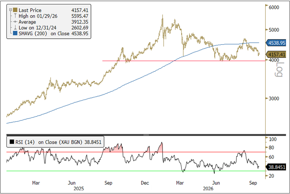
Spot gold fell $279.97 per ounce, or 6.31%, in September to close at $4,157.41. In the third quarter, however, gold gained $149.39, or 3.73%. September was dominated by a rapid rise in real yields and a stronger U.S. dollar. Early in the month, rising short-term yields, together with shifting expectations about likely Federal Reserve (Fed) policy actions, created significant volatility. Following the Fed’s 25 basis point hike on September 16, gold rallied roughly $145 from its intraday low, suggesting that the immediate pressure from rate-hike expectations may have peaked. Attention increasingly shifted toward the long end of the Treasury curve, where rising yields and refinancing costs were worsening the U.S. fiscal outlook.
Figure 1. Gold’s Strong Structural Trends Gold bullion spot price in US$/oz with 14-day relative strength index
Source: Bloomberg. Data as of 10/2/2026. The 14-day RSI (relative strength index) is a momentum oscillator that measures the speed and change in price movements over 14 days, with values ranging from 0 to 100. Levels above 70 indicate overbought conditions, while levels below 30 indicate oversold conditions. Included for illustrative purposes only. Past performance is no guarantee of future results.
Underlying demand remained firm. ETF and futures flows7 recovered toward their January highs, while central bank demand remained historically strong despite slowing from the exceptional pace seen earlier in the year. Chinese physical demand was also notable: non-monetary gold imports to China reached 997 tonnes year-to-date through July, up 80% year-over-year, while August imports were 142 tonnes, up 46%. The increasingly important market tension is that cyclical forces, led by real yields and the U.S. dollar, remain short-term negative for gold. In contrast, structural forces, including fiscal risk, physical demand and reserve diversification, continue to support the longer-term gold thesis.
Gold in the Age of Fiscal Dominance
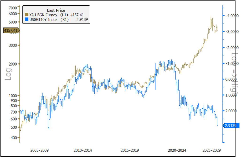
The defining macro development in September was the Treasury bond sell-off, particularly at the long end of the curve. Ten-year real yields, as measured by TIPS,8 approached 3%, rising roughly 49 bps during the month, one of the largest monthly moves in the past 25 years. More broadly, the rise in the 10-year nominal Treasury yield in 2026 has been driven predominantly by real yields, while the break-even inflation yield has moved comparatively little.
This distinction matters for gold. Higher nominal yields driven by inflation expectations can still support gold if real rates remain contained. Higher real yields are more restrictive because they increase the inflation-adjusted return on government bonds and raise the opportunity cost of holding a zero-yielding asset. As Figure 2 highlights, gold has remained unusually resilient despite the sharp rise in real yields, marking a notable divergence from its historically strong inverse relationship with 10-year TIPS yields (note the inverted right axis).
Figure 2. Gold Is Diverging From Real Yields Gold bullion spot price in US$/oz (LHS) and U.S. 10-year TIPS bond yield (RHS, inverted scale), monthly
Source: Bloomberg. Data as of 10/5/2026.
The speed of the move matters as much as the level. Rapidly rising real yields lift discount rates, compress equity valuations and risk premiums, tighten financial conditions and increase the attractiveness of Treasury bonds relative to risk assets. Heavy Treasury supply, large investment-grade issuance associated with the AI capital cycle and reduced demand from less price-sensitive sovereign buyers have added pressure on long-term yields and the term premium. The key question is whether strong growth and earnings can absorb real borrowing costs near 3% or whether the rate shock will eventually restrain consumption, investment and asset prices.
Gold’s resilience signals that fiscal credibility—not just real yields—is increasingly shaping investor demand.
The short-term effect on gold is negative. Yet gold’s resilience is important. If investors can earn close to 3% after inflation on long-duration Treasuries, then gold faces competition. Its ability to hold up suggests growing demand from investors and reserve managers for assets that respond to risks that traditional real-rate models do not fully capture. These include fiscal sustainability, sanctions exposure, jurisdictional risk and the credibility of sovereign debt as a reserve asset.
Why Rising Yields May Strengthen Gold’s Long-Term Case
The deeper significance of the Treasury selloff is that higher yields do not necessarily resolve the underlying fiscal imbalance. In fact, they can worsen it. Large deficits require greater bond issuance, which forces private investors to bear more duration risk. If investors demand higher yields, Treasury interest expense rises just as existing debt is being refinanced. Larger interest expense then widens future deficits and requires still more issuance. The bond market becomes the transmission mechanism through which fiscal expansion collides with restrictive monetary policy.
This marks an important shift away from the post-GFC9 world of monetary dominance and toward a world of fiscal dominance. Under monetary dominance, the central bank can raise rates sufficiently to control inflation without destabilizing government finances. Under fiscal dominance, the scale of the debt outstanding and the cost of servicing it increasingly constrain monetary policy. Tightening suppresses private demand, housing and investment while simultaneously raising the government’s interest burden. The policy intended to restrain inflation can therefore aggravate the fiscal problem.
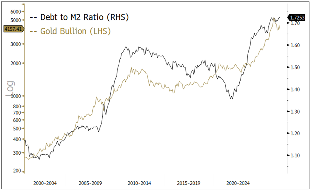
The growing divergence between U.S. federal debt and monetary liquidity (U.S. M2 money supply10) adds to this pressure. The debt-to-M2 ratio (see Figure 3) has risen from roughly 1.35x in 2022 to around 1.73x, above prior-cycle highs, as government debt creation has outpaced money-supply growth. Since the Fed is being restrictive rather than accommodating the fiscal expansion, the adjustment is increasingly being forced through higher bond yields, rising term premiums and tighter private-sector financial conditions. Ultimately, the widening gap between debt and monetary liquidity strengthens the case for some combination of fiscal consolidation, monetary accommodation or financial repression,11 with the latter outcomes particularly supportive for gold.
Figure 3. U.S. Debt Grows Faster Than Money Supply Gold bullion spot price in US$/oz (LHS) and U.S. government debt to U.S. M2 ratio (RHS), monthly
Source: Bloomberg. Data as of 10/5/2026.
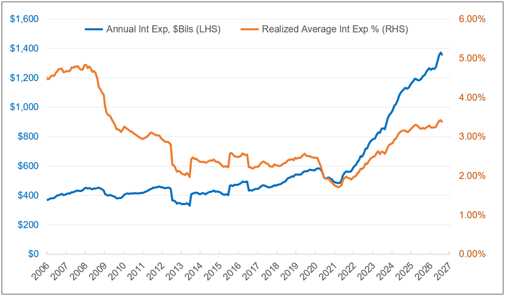
The U.S. Treasury’s refinancing cycle makes the tension increasingly visible. Federal debt totals approximately $40.2 trillion, on which annualized gross interest expense is about $1.36 trillion—a realized average interest rate of just 3.38% across all outstanding debt (see Figure 4). Market rates are now well above that level. As of September 30, Treasury bills were yielding 4.02%, two-year Treasuries 4.89% and 10-year Treasuries 5.28%. As maturing debt rolls over, those higher rates will progressively be reflected in the government’s effective borrowing cost.
Figure 4. The Rising Cost of Borrowing Annual U.S. government debt interest expense, $B (LHS) and realized average interest rate, % (RHS)
Source: Bloomberg. Data as of 9/30/2026.
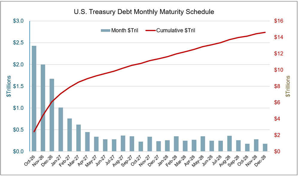
Approximately $10.5 trillion—roughly one-quarter of U.S. federal debt (see Figure 5)—must be refinanced over the next 12 months at these notably higher rates. If debt continues to grow at its recent pace and the average interest rate rises by only 50 bps, annualized interest expense could rise from roughly $1.36 trillion to about $1.67 trillion. The danger is that a self-reinforcing fiscal loop sets in: higher yields increase interest expense, larger interest expense widens deficits, larger deficits require greater Treasury issuance and greater issuance places further upward pressure on yields.
Figure 5. Facing a Near-Term Refinancing Wall U.S. Treasury debt monthly maturity schedule, $Trillions
Source: Bloomberg. Data as of 9/30/2026.
The lag in refinancing is crucial. Interest expense has risen sharply since 2021, while the realized average interest rate cost has climbed more gradually and remains well below current market yields, as shown in Figure 4. This means much of the higher-yield refinancing cycle has not yet been fully passed through to the government’s average borrowing cost. However, total interest expense has increased 2.8x since Q1 2021, growing at a 21% annualized rate, driven by higher total debt and higher yields. Sustained Treasury yields of 4-5% or higher, therefore, become progressively more consequential for the fiscal outlook, even if market rates remain near current levels. Speculation that the U.S. could outgrow its debt does not appear mathematically possible under current conditions.
This is where the short- and long-term implications for gold diverge. Rising real yields are a shorter-term cyclical headwind for gold. However, if those yields expose the economy and the fiscal system’s dependence on low financing costs, they strengthen the structural case for gold. The key transition occurs when policymakers can no longer tolerate the real interest rate required to credibly suppress inflation.
The Economy Takes the Shock
Housing is already showing early signs of pressure. U.S. 30-year fixed mortgage rates reached roughly 7.3% during September as purchase and refinancing activity weakened. Similar pressure should increasingly be reflected in corporate financing costs, investment decisions, equity valuations and household consumption. A 3% real Treasury yield may be attractive to investors, but it also establishes a restrictive benchmark across the financial system.
Energy further complicates the policy dilemma. The U.S.-Iran war and elevated oil, diesel and transportation costs create supply-side inflation that conventional monetary tightening cannot directly resolve. Higher rates cannot increase oil production or refinery capacity; they can only weaken demand elsewhere. An energy shock, therefore, begins as an inflation shock but can evolve into a growth shock through lower purchasing power and higher operating costs. If inflation remains elevated as growth slows, the Fed faces an increasingly unattractive choice between maintaining punitive real rates and protecting growth, financial stability and government financing.
Gold’s strategic value rises as fiscal strain narrows policymakers’ room to maintain restrictive real rates.
The changing base of Treasury buyers strengthens this argument. Official reserve managers have historically purchased government bonds for liquidity, regulatory and strategic reasons rather than solely to maximize returns. As the marginal buyer becomes more price sensitive, investors demand greater compensation for inflation, duration and fiscal risk. Higher yields are the market’s natural solution, but at some point, they may become politically and fiscally intolerable.
Treasury buybacks, maturity management, greater reliance on shorter-term bills and efforts to limit long-duration issuance do not constitute formal yield-curve control. They do, however, show how fiscal pressure can begin to influence the architecture of government financing. Policymakers ultimately have relatively few adjustment mechanisms: fiscal consolidation, faster nominal growth, higher inflation, renewed monetary accommodation or measures that suppress real borrowing costs. With meaningful fiscal consolidation politically difficult and stronger growth uncertain, some combination of monetary accommodation and financial repression becomes an increasingly plausible path of least resistance.
For gold, financial repression is more than inflation; it is a regime in which nominal yields fail to fully compensate investors for inflation, fiscal risk or currency debasement. Sovereign bonds may continue to provide nominal stability, but their real purchasing power becomes less dependable. This is the core of the debasement trade.12 Investors increasingly seek assets that can preserve purchasing power as rising fiscal burdens constrain policymakers’ ability to maintain restrictive real rates. Gold becomes more valuable precisely because it exists outside that policy framework.
Owning Gold Is Not Controlling Gold
The pattern of demand for gold from central banks reflects more than inflation concerns. Reserve managers must increasingly consider the possibility of asset seizure, negative real returns, sanctions risk and an issuing government’s ability to change the rules governing reserve assets. Gold, by contrast, is no one else’s liability. When central banks hold physical gold in their home countries, it reduces both their counterparty exposure and dependence on another country’s legal and financial infrastructure.
This is why reserve location matters. During 2026, France consolidated its remaining foreign-held gold in Paris, while the Netherlands shifted gold out of North America to improve liquidity and access in the event of a crisis. Germany has not initiated a new repatriation program, but there are renewed calls to repatriate its remaining gold held in New York, underscoring a growing focus on jurisdictional control. The broader message is that owning gold and controlling access to gold are not necessarily the same thing.
In a fractured reserve system, ownership of gold matters—but control of it matters more.
China’s development of gold-related infrastructure adds another dimension. China and Hong Kong are developing vaulting, clearing, tokenized gold, Shanghai connectivity and renminbi repo arrangements13 that could make gold more usable as collateral, settlement infrastructure and a reserve asset. This does not require the renminbi to replace the dollar. The more consequential shift may be from a U.S. Treasury-centered reserve system toward a more diversified architecture in which gold plays a larger operational role. Reserve surpluses can increasingly be held in a neutral monetary asset that does not depend on another sovereign’s fiscal credibility, political decisions or sanctions framework.
September highlighted the central tension in the gold outlook. Higher real yields remain gold’s most important cyclical risk. If real yields near 3% can persist alongside robust growth, fiscal sustainability and financial stability, gold could remain under pressure. But if restrictive real rates weaken housing and investment, raise debt-service costs and expose the system’s dependence on inexpensive funding, the same forces weighing on gold today may ultimately create the conditions for the policy response that supports it tomorrow.
Strong growth, supply constraints, energy inflation and heavy issuance are currently supporting higher real yields and creating a difficult backdrop for gold. The next phase begins when those real rates generate sufficient economic, financial or fiscal stress. If deficits and inflation remain elevated as growth weakens, policymakers will face a choice between sustaining monetary credibility and preserving system stability. That is the pathway from a real-rate shock toward fiscal dominance, financial repression and lower real returns on sovereign debt.
Gold’s resilience suggests this longer-term transition may already be influencing investor behavior. September’s bond sell-off is both a near-term headwind and a longer-term validation of the structural thesis. As the tension between monetary credibility and fiscal sustainability intensifies, the strategic case for gold strengthens: it is an asset outside the sovereign liability structure and, when physically controlled, outside another country’s jurisdiction.
Silver Faces Macro Headwinds, but Industrial Demand Remains Supportive
Spot silver prices fell to $60.43 from $66.58 in September, a 9.24% decline. However, silver finished the quarter up 3.12% from its start.14 Silver’s monetary factor remained the key driver of price moves, impacted by the same rapid rise in rates and dollar-strength tailwinds that weighed on gold. Silver-related ETFs also experienced net outflows amid negative monthly momentum.
Freely available silver supply is materially higher year-over-year (YoY), with inventories showing greater stability YoY, indicating a market that is largely in balance for the time being. PV-solar-related industrial demand among Chinese buyers appears set to fall in late 2026, largely due to continued silver thrifting and improved industrial methods, although we note that this factor may see diminishing returns over time.15 Supply side factors have added to the ongoing macro tailwinds for silver, driving its relative underperformance versus gold.
Shanghai premiums signal that Chinese demand for silver remains a key source of support.
Despite the muted forecast for solar PV demand, Shanghai Silver Premiums have remained materially elevated since the end of 2025, suggesting a persistently strong relative Chinese demand for silver even as physical inventories have largely replenished from last year’s lows.16 The recent improvement in Chinese factory activity also offers evidence that broader industrial demand remains intact. The official Chinese purchasing managers’ index (PMI) rose to 50.1 in September from 49.8 in August, ending two consecutive months of contraction, indicating a constructive signal for silver-intensive applications, such as electrical applications, robotics and AI-related infrastructure.17
While silver remains subject to the same rate-related headwinds that impact gold, it has the potential to outperform should rate pressures ease and markets stabilize. Market consensus points to the September spike in yields being driven by real rates and a resilient U.S. economy, both of which have weighed on the precious metals sector through the opportunity-cost effect. However, given silver’s dual role as both a precious and an industrial metal, continued strength in industrial demand is likely to provide additional support and contribute to relative outperformance as macro headwinds stabilize.
Looking ahead, although long-term yields have continued to rise, technical indicators are showing signs of exhaustion in the current bearish bond trend, suggesting the recent move in yields may be approaching an inflection point.18 We also point to the upcoming U.S. midterm election and the potential for divided government in Washington. Such an outcome could constrain the scope of aggressive fiscal outcomes, potentially removing some upward pressure on long-term yields.19 While considerable uncertainty remains, any sustained easing of rate pressures alongside resilient industrial demand could improve the relative risk/reward dynamic for silver.
Footnotes
1
Gold bullion is measured by the Bloomberg GOLDS Comdty Index.
2
Silver bullion is measured by the Bloomberg Silver (XAG Curncy) U.S. dollar spot rate.
3
The NYSE Arca Gold Miners Index (GDM) is a rules-based index designed to measure the performance of highly capitalized companies in the gold mining industry.
4
The Bloomberg Commodity Index (BCOM) is a broadly diversified commodity price index distributed by Bloomberg Indices.
5
The U.S. Dollar Index (USDX, DXY, DX) is an index (or measure) of the value of the United States dollar relative to a basket of foreign currencies, often referred to as a basket of U.S. trade partners’ currencies.
6
The S&P 500 or Standard & Poor’s 500 Index is a market-capitalization-weighted index of the 500 largest U.S. publicly traded companies.
7
Refers to futures and options positions in gold and ETF gold holdings as reported monthly by the U.S. Commodity Futures Trading Commission, which provides insight into speculative and institutional demand for gold.
8
TIPS (Treasury Inflation-Protected Securities) are U.S. government bonds whose principal adjusts with inflation (pegged to the CPI), so their yields reflect a “real” or inflation-adjusted return rather than a nominal one.
9
Post-GFC: refers to the lengthy period following the Great Financial Crisis of 2008/09, when central banks established significant influence over financial markets and economic conditions by using policies like quantitative easing. This dominance was characterized by central banks making substantial asset purchases and attempting to keep interest rates low to encourage growth.
10
The U.S. M2 money supply is a measure of the total money supply in the U.S. economy. It includes M1 (cash and checking deposits) plus savings deposits, small-denomination time deposits and balances in retail money market mutual funds. This represents money that is less liquid than M1 but can be converted into cash quickly.
11
Financial repression refers to government policies that keep interest rates low and channel funds to the public sector, often resulting in savers earning returns below inflation. This approach is used to reduce a country’s debt-to-GDP ratio and can have significant long-term economic implications.
12
The debasement trade is the strategy of shifting into hard assets like gold or other commodities on the expectation that governments will let currencies lose purchasing power through persistent deficits, rising debt and inflation rather than address fiscal imbalances through policy and discipline.
13
China and Hong Kong are attempting to build an Asian alternative to London’s gold infrastructure. The Chinese central bank is shifting some reserves from London into Hong Kong’s expanding vaults and is trying to persuade other countries to hold their gold there or in the Shanghai Gold Exchange (SGE) vaults. A state-owned central clearing system entered trial in July 2026, featuring SGE connectivity, yuan gold futures and new renminbi liquidity facilities. China is also experimenting with tokenized gold and a gold-collateralized renminbi repurchase facility.
Country* United States Canada Argentina Australia Austria Belgium Brazil China Denmark Finland France Germany India Ireland Italy Japan Netherlands New Zealand Norway South Africa Spain Sweden Switzerland United Kingdom Other
I am not a robot.
Please slide to unlock.
I consent to Sprott Inc. and its subsidiaries sending me newsletters, fund information and other electronic messages (E-Communications)*
This article discusses a range of potential economic scenarios that could arise if current geopolitical conditions persist or deteriorate. These scenarios, including those expressed in the present or future tense, are illustrative only and should not be viewed as predictive, promissory or guaranteed.
Relative to other sectors, precious metals and natural resources investments have higher headline risk and are more sensitive to changes in economic data, political or regulatory events, and underlying commodity price fluctuations. Risks related to extraction, storage and liquidity should also be considered.
Gold and precious metals are referred to with terms of art like “store of value,” “safe haven” and “safe asset.” These terms should not be construed to guarantee any form of investment safety. While “safe” assets like gold, Treasuries, money market funds and cash generally do not carry a high risk of loss relative to other asset classes, any asset may lose value, which may involve the complete loss of invested principal.
Past performance is no guarantee of future results. Investments, commentary and statements are unique and may not be reflective of investments and commentary in other strategies managed by any other Sprott entity or affiliate. Opinions expressed in this presentation are those of the presenters and may vary widely from opinions of other Sprott affiliates. Forward-looking language should not be construed as predictive. While third-party sources are believed to be reliable, Sprott makes no guarantee as to their accuracy or timeliness. This information does not constitute an offer or solicitation and may not be relied upon or considered to be the rendering of tax, legal, accounting or professional advice. It does not constitute a recommendation to purchase, sell or hold gold, silver, mining equities, exchange-traded products or any other investment.
Complete results from first drillholes campaign with significant Copper-Gold Mineralization at Pimentón Project
2026 Diamond Drilling Program Confirms and Extends Historical Copper-Gold Mineralization; Drilling Completed 3,084 m Across Four Holes.
Toronto, Ontario–(Newsfile Corp. – August 20, 2026) – Irruptive Metals Corp. (TSXV: IRR) (“Irruptive Metals” or the “Company“), an emerging copper-gold exploration company advancing the high-potential Pimentón Project located in the V Region, Central Chile, is pleased to announce the completion of its first diamond drill campaign, totalling 3,084 metres across four drillholes (IMP001 to IMP004), designed to test the central Cu-Au porphyry system within the Company’s flagship project. All assay results have now been received, validated, and incorporated into the geological model.
Drill Program Highlights
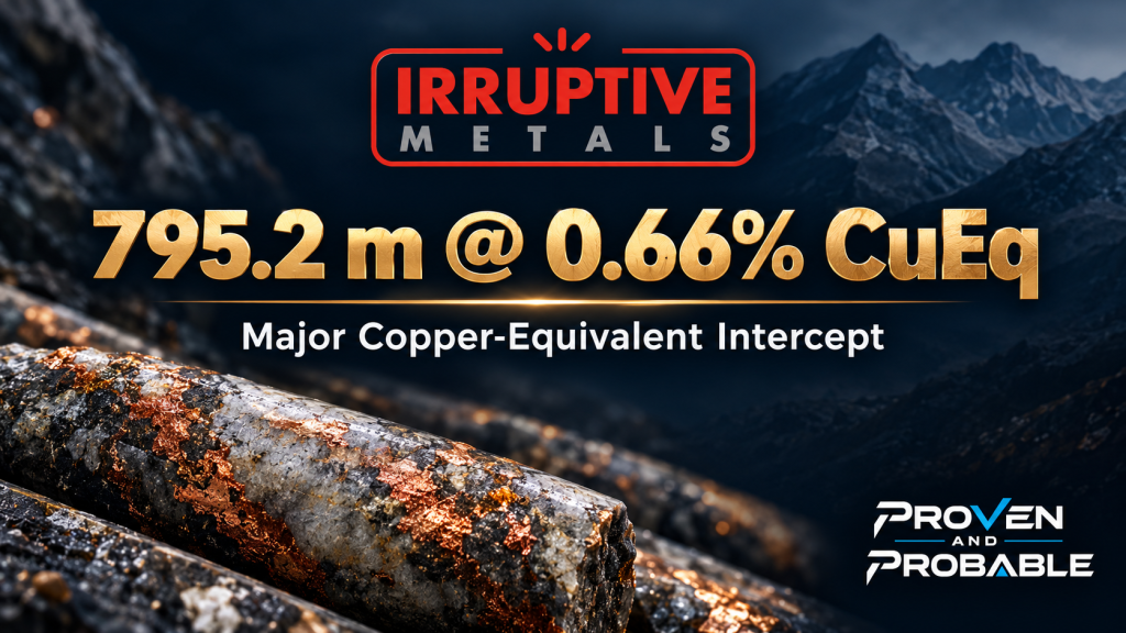
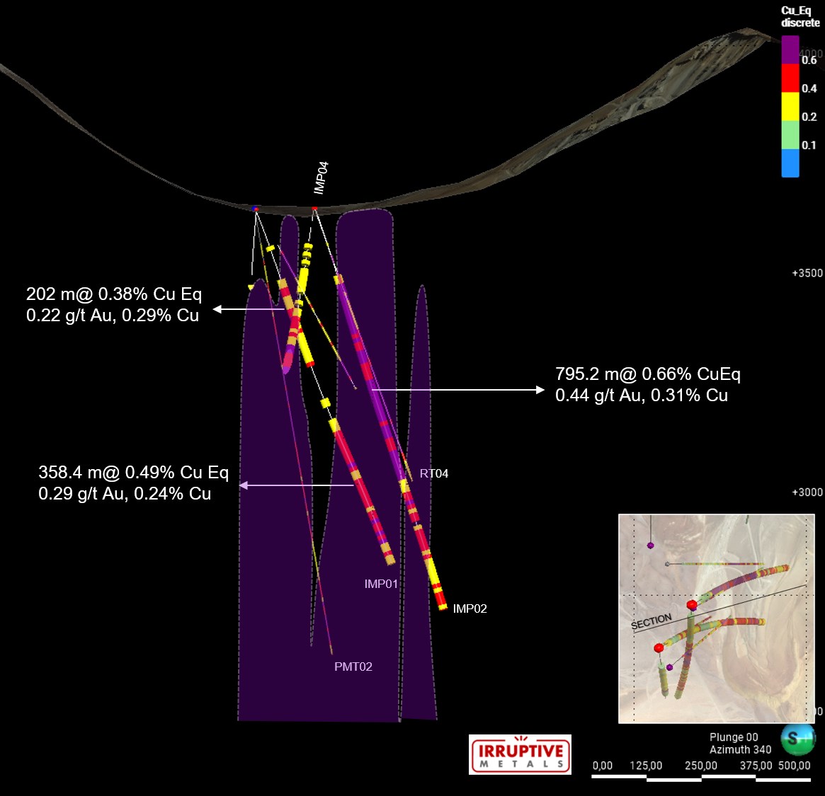
IMP002 returned 795.2 m with 0.66% CuEq (0.41 g/t Au, 0.31% Cu) from 167 m to end of hole at 962.2 m, including a gold-dominant high-grade interval of 60 m grading 1.49% CuEq (1.37 g/t Au, 0.31% Cu)
IMP001 returned two significant intervals: 202 m with 0.38% CuEq (0.22 g/t Au, 0.19% Cu) from 177 m to 379 m, and 358.4 m with 0.49% CuEq (0.29 g/t Au, 0.24% Cu) from 513 m to 871.4 m (EOH)
IMP003 returned 42 m with 0.25% CuEq (0.12 g/t Au, 0.15% Cu) from 171 m to 213 m and 176 m with 0.31% CuEq (0.15 g/t Au, 0.18% Cu) from 227 m to 403 m
IMP004 returned 406 m with 0.47% CuEq (0.26 g/t Au, 0.25% Cu) from 259 m to 665 m.
Results confirm and extend historical drilling by Rio Tinto and Anglo American, demonstrating geological continuity across the Central target area
Drill program completed 3,084 m of drilling across four holes from two platforms, with operations concluded on April 17, 2026
“These results from our 2026 drilling program are highly encouraging and confirm the significant copper-gold potential at Pimentón,”said Alfredo Bazo, President and CEO of Irruptive Metals. “The consistency of our results with historical drilling by Rio Tinto and Anglo American validates our geological model. We are particularly pleased with the 795-metre intercept in IMP002, which demonstrates both the scale and grade potential of the Central target. We look forward to advancing the project toward resource definition as we prepare for our next drilling campaign, as the mineralization remains open.”
The 2026 diamond drilling program was designed to twin or near-twin historical drillholes completed by Rio Tinto and Anglo American, with the objective of confirming historical geological and grade information and testing lateral and vertical extensions of known mineralization. The historical datasets were reviewed by Román Flores, P.Geo., author of the Company’s NI 43-101 Technical Report on the Pimentón Project (effective July 20, 2026). Mr. Flores is independent of Irruptive Metals for the purposes of Section 1.5 of National Instrument 43-101 and is a Qualified Person under NI 43-101.
Results obtained to date are consistent with the historical datasets and support the reliability of the original drilling. No mineral resource or mineral reserve has been estimated on the Pimentón Project, and the mineralization described in this news release is not necessarily indicative of the presence of a mineral resource or mineral reserve.
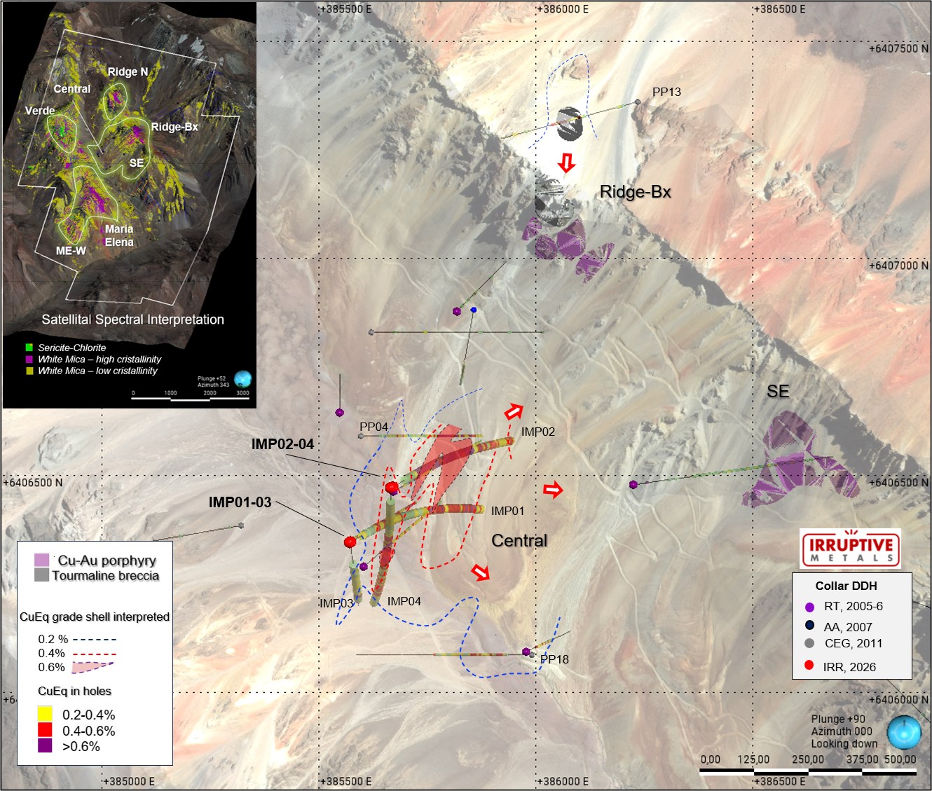
Using the same drill platforms as holes IMP001 and IMP002, IRR completed two additional holes (IMP003 and IMP004) oriented to the south (azimuth 180°, dip -70°) to evaluate the potential southward extension of the mineralized system. Hole IMP004 successfully intersected the targeted Cu-Au porphyry mineralization, including vein styles, sulfide assemblages and alteration consistent with the mineralized center defined in IMP001 and IMP002. These results provide additional evidence that the porphyry system remains open to the southeast, east and northeast supporting continued step-out drilling in that direction.
Mineralization is associated with a complex of Cu-Au porphyry dykes exhibiting potassic alteration (K-feldspar, biotite), EB-type and A-type veins. Higher-grade zones correspond to early mineral porphyry phases overprinted by green-sericite-chalcopyrite assemblages. Some High-sulfidation Au-Ag-Cu vein systems appear telescoped over porphyry and also located peripheral to the center.
The geological interpretation, based on the integration of new drillholes and historical datasets, identifies a Cu-Au porphyry dyke complex with an NNE orientation and near-vertical dip. This Cu-Au porphyry corridor is currently 600 metres long, 300 metres wide and is open to the E, SE, NE and W, representing the principal conduit for mineralization within the Central Target. The geometry and orientation of these dykes provide a coherent framework that explains the distribution of potassic-centred mineralization, the green sericite high-grade transitional halo, and peripheral alteration zones observed across both historical and recent drilling.
Outlook and Next Steps
Reprocessing of historical geophysics (Magnetometry, IP-Res & MT) to improve and prioritize targets, Q3-2026
Conduct geometallurgical sampling and mineralogical/metallurgical test work
Resampling historical holes in central target (PP18 & PP04) to include in updated NI 43-101 Technical Report with initial inferred resource estimate, Q1-2027
Advance drilling to test lateral and deep extensions of the Central target to expand the initial resources, Q4 2026 to Q1 2027
Obtain the environmental permits (DIA) to drill the Ridge-Bx, SE, Verde and Maria Elena targets to consolidate the Pimentón project as a high-potential Cu-Au resource, Q1 2028
Table 1: Summary of Significant Drill Intercepts
Drill Results Summary
From
To
Length (m)
Au g/t
Cu %
CuEq %
Hole
IMP001
177
379
202
0.22
0.19
0.38
513
871.4
358.4
0.29
0.24
0.49
IMP002
167
962.2
795.2
0.41
0.31
0.66
High grade zone
181
317
136
0.44
0.43
0.81
327
387
60
1.37
0.31
1.49
IMP003
171
213
42
0.12
0.15
0.25
227
403
176
0.15
0.18
0.31
IMP004
259
665
406
0.26
0.25
0.47
Notes: Intervals are reported using a cut-off of CuEq >0.2% with three dilution samples (6 m) and no top-cut applied. CuEq = Cu% + (Au g/t × 0.86). Metal prices used are the two-year average (2024-2025): US$4.95/lb Cu and US$2,918/oz Au. Recoveries were assumed equal for all metals. CuEq is used for comparison purposes only. No metallurgical recovery testwork has been completed on the Project; equal recoveries have been assumed for all metals for illustrative purposes only, so the reported CuEq values may not be representative of recoverable or economically recoverable metal.
Reconciliation with Technical Report: These results are final and, where they differ, update the preliminary intercepts disclosed in the NI 43-101 Technical Report (July 20, 2026). Intervals in this release are composited using three dilution samples (6 m); the Technical Report used two dilution samples. Reported intervals are therefore not directly comparable to that report, and the 478 m at 0.80% CuEq interval shown for IMP002 in the Technical Report is not reproduced here.
True Widths: All reported intervals are downhole core lengths. True widths have not yet been determined and are expected to be less than the reported downhole lengths.
Table 2: Drillhole Collar Locations
Hole ID
Easting (m)
Northing (m)
Elevation (m)
Azimuth (°)
Dip (°)
EOH depth (m)
IMP001
385571
6406345
3627
60
−70
871.4
IMP002
385670
6406472
3629
60
−70
962.2
IMP003
385573
6406346
3627
180
-70
503
IMP004
385666
6406471
3629
180
-70
747.3
Note: Coordinates are in WGS84 Zone 19S.
Figure 1: Plan view showing location of Irruptive Metals’ and historical drillholes, CuEq grade shell interpretation at 3200m of elevation in Central target, and key outcrops (Cu-Au porphyry and tourmaline breccia) in Ridge-Bx and SE targets.
Drill core was logged, sampled, and cut under the supervision of Company geologists. Samples were prepared and analyzed by AGS-Cotecna laboratory, which is independent of the Company and an ISO/IEC 17025-accredited laboratory. Gold assays were completed using fire assay with AAS finish. Multi-element determination was completed by four-acid digestion (HF-HNO₃-HClO₄-HCl) followed by ICP-OES analysis. The Company maintains a rigorous QA/QC program including the insertion of certified reference materials (5%), blanks (2.5%), and field duplicates (2.5%) at regular intervals. No material QA/QC issues were identified in the reviewed data. The Qualified Person has verified the data underlying the technical information disclosed in this news release, including by reviewing the assay results, the QA/QC data and the sampling and analytical procedures, and is not aware of any drilling, sampling, recovery or other factors that could materially affect the accuracy or reliability of the data.
Qualified Person
The scientific and technical information in this news release has been reviewed and approved by Claudio Burgoa, P.Geo., Chief Geologist of Irruptive Metals, a qualified person for the purposes of National Instrument 43-101 – Standards of Disclosure for Mineral Projects and Qualified Person #535, Comisión Minera de Chile.
About Irruptive Metals Corp.
Irruptive Metals Corp. (TSXV: IRR) is a Canadian copper-gold exploration company focused on unlocking value from high-quality mineral projects in Chile. The Company’s flagship Pimentón Project is strategically located within one of the world’s most prolific porphyry copper-gold belts and has been the subject of extensive historical exploration by major mining companies, underscoring its significant discovery potential.
100 King Street, Suite 3400, Toronto, ON, Canada, M5X 1A4
Forward-Looking Statements
This news release contains forward-looking statements and forward-looking information (collectively, “forward-looking statements”) within the meaning of applicable securities laws. Any statements that are contained in this news release that are not statements of historical fact may be deemed to be forward-looking statements. Forward-looking statements are often identified by terms such as “may”, “should”, “anticipate”, “will”, “estimates”, “believes”, “intends”, “expects” and similar expressions which are intended to identify forward-looking statements.
More particularly and without limitation, this news release contains forward-looking statements that include, but are not limited to, statements regarding the Company’s drill program results, exploration targets, geological interpretations, future resource evaluation work, and the potential advancement of the Pimentón Project.
Forward-looking statements are inherently uncertain, and the actual performance may be affected by a number of material factors, assumptions and expectations, many of which are beyond the control of the Company, including expectations and assumptions concerning the Company and the Pimentón Project. Readers are cautioned that assumptions used in the preparation of any forward-looking statements may prove to be incorrect. Events or circumstances may cause actual results to differ materially from those predicted as a result of numerous known and unknown risks, uncertainties and other factors, many of which are beyond the control of the Company. Readers are further cautioned not to place undue reliance on any forward-looking statements, as such information, although considered reasonable by the management of the Company at the time of preparation, may prove to be incorrect and actual results may differ materially from those anticipated.
Additional information, including risks facing the Company, are outlined in the Company’s Filing Statement dated July 20, 2026, which is available on SEDAR+ (www.sedarplus.ca) under the Company’s issuer profile. The forward-looking statements contained in this news release are made as of the date of this news release and are expressly qualified by the foregoing cautionary statement. Except as expressly required by securities law, the Company does not undertake any obligation to update publicly or to revise any of the included forward-looking statements, whether as a result of new information, future events or otherwise.
Neither the TSX Venture Exchange nor its Regulation Services Provider (as that term is defined in the policies of the TSX Venture Exchange) accepts responsibility for the adequacy or accuracy of this release.
Management to attend AUSA 2026 Annual Meeting and Exposition in Washington, D.C., October 12-14
HAGERSTOWN, MD / ACCESS Newswire / October 8, 2026 / First Breach Inc. (NASDAQ:FBDT) (“First Breach” or the “Company”), an American-made defense technologies company focused on vertically integrated ammunition production and next-generation unmanned aerial systems, today announced an expanded recruitment initiative to support increased ammunition production and the planned buildout of its drone manufacturing operations in Hagerstown, Maryland.
The initiative is intended to strengthen the Company’s workforce as it scales its ammunition business and develops the technical and operational capabilities needed for its unmanned systems programs.
“Building our workforce is an important part of our efforts to expand ammunition production and prepare for planned drone manufacturing operations,” said Jeffrey Low, Co-Founder and Chief Executive Officer of First Breach. “We are looking to bring additional talent into the Company to support these efforts as we develop our U.S. manufacturing capabilities.”
Interested candidates are encouraged to inquire about employment opportunities and submit their resumes through the Company’s career application page.
Management to Attend AUSA 2026
Members of First Breach’s management team will also attend the Association of the United States Army (AUSA) 2026 Annual Meeting and Exposition, taking place October 12-14 at the Walter E. Washington Convention Center in Washington, D.C.
The annual event brings together military leaders, government representatives, defense companies and international delegations to discuss Army priorities, emerging technologies and the future of land warfare. First Breach management looks forward to on-site meetings with industry participants to discuss the Company’s ammunition capabilities and developing unmanned systems business, explore potential collaborations and better understand customer requirements.
Industry participants interested in arranging an on-site meeting with First Breach management may contact Ken Leith, Chief Revenue Officer, at ken@firstbreach.com. Additional information about the conference is available at the AUSA 2026 Annual Meeting and Exposition website.
About First Breach
First Breach Inc. is an ISO 9001:2015 certified, American-made defense technologies company focused on manufacturing match-grade ammunition components, finished ammunition, and developing next-generation unmanned aerial systems for commercial, law enforcement, and military markets. The Company manufactures its products in-house at its Hagerstown, Maryland facility, where it produces brass cups, casings, projectiles, lead cores, lead wire, and completed ammunition with rigorous quality control standards. First Breach is also advancing its drone strategy through the development of U.S.-made unmanned systems, leveraging advanced engineering, robotics, ISR and sensor technologies, and precision manufacturing capabilities to address evolving defense, homeland security, law enforcement, and commercial requirements across domestic and international markets.
This press release contains forward-looking statements within the meaning of the Private Securities Litigation Reform Act of 1995. Forward-looking statements are not historical facts and include statements regarding the Company’s expectations, beliefs, plans, objectives, strategies, future events, future performance, business prospects, growth initiatives, acquisitions, market opportunities, capital resources, operational objectives, and other statements that are predictive in nature. Forward-looking statements may be identified by the use of words such as “anticipate,” “believe,” “continue,” “could,” “estimate,” “expect,” “forecast,” “intend,” “may,” “plan,” “potential,” “predict,” “project,” “seek,” “should,” “target,” “will,” “would,” and similar expressions, although not all forward-looking statements contain these identifying words.
Forward-looking statements are based on management’s current expectations, assumptions, and beliefs regarding future developments and their potential effect on the Company. These statements are not guarantees of future performance and involve known and unknown risks, uncertainties, assumptions, and other factors that may cause actual results, performance, or achievements to differ materially from those expressed or implied by such forward-looking statements.
Factors that could cause actual results to differ materially from those expressed or implied by forward-looking statements include, but are not limited to, changes in economic, business, market, competitive, regulatory, technological, legal, and geopolitical conditions; the Company’s ability to execute its business strategy; access to capital and financing; customer demand; industry developments; and other risks and uncertainties described from time to time in the Company’s filings with the U.S. Securities and Exchange Commission, which are available for review at www.sec.gov.
Readers are cautioned not to place undue reliance on forward-looking statements, which speak only as of the date they are made. Except as required by applicable law, the Company undertakes no obligation to update, revise, or publicly disclose any revisions to any forward-looking statements to reflect events, circumstances, or changes in expectations occurring after the date of this press release.
I first wrote about a new advertiser named Sage Potash last June. In that piece I wanted to make the point that having a single country potentially controlling a substantial flow of major commodities such as oil and oil related products was especially dangerous for the world economy. It doesn’t make any difference if that country is considered a friend or foe.
That’s exactly the situation Trump has dragged the US into to pay for and fight a war against a country not our enemy. But Israel controls Congress, they control the Senate, now the military and certainly own Donald J. Trump. It’s a war for Israel, not a war the US stands to gain anything. But Israel hates all their neighbors and whines on a constant basis about how they, Israel, are the victims. They are not.
Countries of the world need to be thinking seriously about a Plan B. Anything energy related needs to be considered. Having an alternative source of supply could easily mean issues of life and death. We are going to understand that better this winter when foolish energy decisions such as that of Germany allowing the US military to blow up 75% of the four Nord Stream pipelines cause Europeans to freeze and potentially starve due to the cost and availability of energy and energy products.
Fertilizer is a perfect example. Many of the inputs to fertilizer are produced as a byproduct of refining crude oil such as sulfur. Due to this incredibly stupid and pointless war, the costs of farming such as diesel fuel and urea or sulfur have shot through the roof.
A tiny company in Utah heard a knock on the door and found to their great pleasure that it was opportunity knocking. Sage Potash (SAGE-V) owns a 345 square km potash property in a basin in Utah. Based on the first drill hole they put down named Johnson 1 the company has an existing 43-101 inferred resource of 298.1 million tonnes of high-grade potash. Obviously right from the start it is going to be difficult for potential investors to understand what value the company offers so I am going to lead you through how to determine that.
With some flat lying sedimentary minerals such as coal and potash even a single hole can generate an inferred resource. The theory being that since it is a flat deposit of sedimentary material even a single hole will suggest similar material surrounding the hole. In the case of the first hole, named Johnson 1, the QP used a circle around the hole with a diameter of 2.4 km. The QP concluded the grade of the hole and thickness justified an inferred resource of 298.1 million tonnes at an average of about 40% potash.
The potash market has been relatively stable for the last couple of years because potash doesn’t come from natural gas or crude oil. The value of a tonne of potash in the markets the Utah based Sage would serve would be about $472.50. If you multiply the resource of 298.1 million tonnes by an average grade of about 40% and factor in the current price of $472.50 the theoretical value of the potash in the ground would be about $56 billion in USD.
Here is where it gets very interesting. I have looked at the capex and Opex of other potash companies and it looks to me as if the company could in theory net about $300 a tonne and produce between one and two million tonnes a year. The Capex is not cheap, it could be in the $1 to $2 billion range.
The real news beyond the excellent drill results from Hole 2, named Peterson 1 released on September 28th and promptly ignored by investors is just how it will affect the 43-101 numbers.
If you look at the chart we prepared below. The black circle reflects the 298.1 million tonnes with the resource derived from the Johnson 1 hole. And now the company has drilled the Peterson 1 hole just 1 km to the NE. That hole is surrounded by a 2.4 km diameter dashed line. If the QP shows that in the 43-101 coming in about a month, the red area in between Johnson and Peterson will almost certainly qualify as Measured and Indicated. The green quarter moons above and below the holes will almost certainly be Inferred. So it looks to me as if the resource will only grow perhaps 25% but the high-grade resource shown in red will be about 50% of the total. That’s a giant move higher in confidence and should draw the attention of majors.
The grade of the potash shown in both holes is exceptional and is among the highest grade in the world. It certainly looks to me as if this will be put into production. The US needs to control the inputs to its own agriculture industry.
Sage is an advertiser and I have bought shares in the open market. Naturally I am biased so do your own due diligence. Their only problem is a lack of visibility.
Sage Potash Corp SAGE-V $.13 Oct 01, 2026 SGPTF-OTCQB 171 million shares Sage Potash website
Vancouver, British Columbia–(Newsfile Corp. – October 1, 2026) – West Point Gold Corp. (TSXV: WPG) (OTCQX: WPGCF) (FSE: LRA0) (“West Point Gold” or the “Company”) is pleased to report that following the receipt of permits and the completion of bonding, Kinross Gold U.S.A., Inc. (“Kinross”), a wholly owned subsidiary of Kinross Gold Corporation, has commenced drilling at West Point Gold’s Jefferson Canyon project in Nye County, Nevada.
Highlights
Kinross has commenced drilling on September 23, 2026, at West Point Gold’s Jefferson Canyon, located approximately 7 kilometres from its Round Mountain operations.
Partner-funded exploration allows West Point Gold to retain exposure to Jefferson Canyon while allowing the Company to remain focused on its flagship Gold Chain Project.
Permits were received August 19, 2026, starting the four-year option period laid out in the 2022 Exploration and Option Agreement (the “Agreement”).
The Agreement provides for the potential of up to US$10 million in future option payments.
West Point Gold retains meaningful long-term exposure to Jefferson Canyon, including a 20% project interest if both Kinross options are exercised and royalty protection should its interest subsequently be diluted below 10%.
“We are excited that drilling has begun at West Point Gold’s Jefferson Canyon project. The historical drilling and work we previously completed suggest this project has the potential to deliver a significant deposit. Given the project’s proximity to Kinross’s Round Mountain mine and our partnership on the Jefferson Canyon project with Kinross, we believe the hurdle rate to define a mineable deposit is relatively low,” stated Derek Macpherson, President & CEO.
Jefferson Canyon Project, Nevada The Jefferson Canyon project in Nye County, Nevada is located 7 kilometres from Kinross’s Round Mountain operations (Figure 1). The project has 145 historical drill holes, including 41.2m at 6.4 g/t gold and 402 g/t silver (GJ-81). In 2022, West Point Gold entered into an Exploration and Option Agreement with Kinross (the “Agreement”). Kinross has made all the required payments associated with the agreement to date.
Figure 1: Jefferson Canyon Project Relative to Round Mountain
The Jefferson Canyon project contains a large volcanic-hosted epithermal Au-Ag system that is essentially the same age as the nearby Round Mountain deposit, a world-class low-sulfidation (LS) epithermal deposit. Both are hosted in felsic ash-flow tuffs along the margins of calderas and both contain a strong northwest-trending and north-south structural control to veins. Both areas contain low-grade disseminated and high-grade vein or replacement-type mineralization.
Historical drilling has defined multiple zones of mineralization (Figure 2) and has been highlighted by multiple significant drill intercepts, including 41.2m of 6.4 g/t Au and 402 g/t Ag (GJ-81).
Figure 2: Historical Drill Holes and Mineralized Envelope along the Jefferson Canyon (“JF”) Fault
Soil sampling in 2021 revealed a four-square-kilometre circular gold-in-soil anomaly (Figure 3). The highest Au-in-soil value was 4,470 parts per billion Au and anomalous values were distributed as follows: 29 samples contained greater than 500 parts per billion Au; 99 samples were greater than 200 ppb Au; 234 samples were greater than 100 ppb Au; and, 631 samples were greater than 20 ppb Au. The five rock samples collected were anomalous, with values of up to 15.2 g/t gold and 421 g/t silver.
Figure 3: Gold-in-Soil and Silver-in-Soil Anomalies at Jefferson Canyon with historical drill collars
The CSMAT resistivity data suggests that the Jefferson Canyon fault is a deep structure which likely controls mineralization. This spatial relationship to the gold-silver mineralization supports the potential to expand the mineralized footprint both along strike and depth. A large conductor is evident down plunge along the northeast-dipping Jefferson Canyon fault.
Figure 4: CSAMT /Resistivity Model Showing the Projection of the Jefferson Canyon Fault at Depth
Kinross will continue making ongoing lease payments of US$75,000 per year for the term of the agreement.
Kinross is required to spend US$600,000 on exploration work and will be responsible for making the payments to keep the unpatented claims in good standing.
During the term of the agreement, Kinross has the option to acquire 70% of the project for a cash payment of US$5,000,000 to West Point Gold and form a joint venture LLC, and a second option to acquire an additional 10% of the project for a further payment of US$5,000,000 to the Company.
The term of the Agreement is four years commencing from receipt of drill permits, with a potential extension of up to two years, subject to certain conditions. Drill permits were received on August 19, 2026.
If an LLC is formed, and either party is diluted below 10%, its interest converts to a 1% net smelter returns (NSR) royalty.
Marketing Engagements The Company has engaged New Era Publishing Inc. (“New Era”), also doing business as Katusa Research, an arm’s-length service provider, to provide the Company certain investor relations and marketing services, in accordance with the policies of the TSX Venture Exchange and applicable securities laws. Based in Vancouver, B.C., New Era specializes in media and investor relations services within the natural resource sector. Under a consulting agreement dated September 8, 2026, New Era will provide media relations, investor communication and market awareness services to the Company for a two-month term for a one-time fee of US$150,000, payable at the commencement of services. The Company will not issue any securities to New Era as compensation for its services. As of the date hereof, to the Company’s knowledge, New Era (including its directors and officers) does not own any securities of the Company. The marketing agreement with New Era is subject to TSX Venture Exchange approval.
Additionally, the Company has engaged Freedom Financial Research, LLC (“Freedom Financial”), an arm’s-length service provider, to provide the Company certain investor relations and marketing services, in accordance with the policies of the TSX Venture Exchange and applicable securities laws. Based in Charlottesville, Virginia, Freedom Financial specializes in media and investor relations services. Under a consulting agreement dated September 11, 2026, Freedom Financial will provide media relations, investor communication and market awareness services to the Company for a 90-day term for a one-time fee of US$150,000, payable at the commencement of services. The Company will not issue any securities to Freedom Financial as compensation for its services. As of the date hereof, to the Company’s knowledge, Freedom Financial (including its directors and officers) does not own any securities of the Company. The marketing agreement with Freedom Financial is subject to TSX Venture Exchange approval.
Qualified Person Robert Johansing, M.Sc. Econ. Geol., P. Geo., the Company’s Vice President, Exploration, is a qualified person (“QP”) as defined by NI 43-101 and has reviewed and approved the technical content of this press release. The QP has not completed sufficient work to verify the historical information on the properties, particularly regarding historical drill results. However, the QP believes prior drilling and analytical results were completed in accordance with industry-standard practices.
About West Point Gold Corp. West Point Gold is an exploration and development company focused on unlocking value across four strategically located projects along the prolific Walker Lane Trend in Nevada and Arizona, USA, providing shareholders with exposure to multiple discovery opportunities across one of North America’s most productive gold regions. The Company’s near-term priority is advancing its flagship Gold Chain Project in Arizona.
For further information regarding this press release, please contact: Aaron Paterson, Corporate Communications Manager Phone: +1 (778) 358-6173 Email: info@westpointgold.com
FORWARD-LOOKING STATEMENTS: Certain statements contained in this press release constitute forward-looking information. These statements relate to future events or future performance. Forward-looking statements include estimates and statements that describe the Company’s future plans, objectives or goals, including words to the effect that the Company or management expects a stated condition or result to occur. The use of any of the words “could”, “intend”, “expect”, “believe”, “will”, “projected”, “estimated” and similar expressions and statements relating to matters that are not historical facts are intended to identify forward-looking information and are based on the Company’s current belief or assumptions as to the outcome and timing of such future events including, among others, assumptions about future prices of gold, silver, and other metal prices, currency exchange rates and interest rates, ability to define economic mineralization, favourable operating conditions, political stability, obtaining government approvals and financing on time, obtaining renewals for existing licenses and permits and obtaining required licenses and permits, labour stability, stability in market conditions, availability of equipment, availability of drill rigs, and anticipated costs and expenditures. The Company cautions that all forward-looking statements are inherently uncertain, and that actual performance may be affected by a number of material factors, many of which are beyond the Company’s control. Such factors include, among other things: risks and uncertainties relating to West Point Gold’s ability to complete any payments or expenditures required under the Company’s various option agreements for its projects; and other risks and uncertainties relating to the actual results of current exploration activities, the uncertainties related to resources estimates; the uncertainty of estimates and projections in relation to production, costs and expenses; risks relating to grade and continuity of mineral deposits; the uncertainties involved in interpreting drill results and other exploration data; the potential for delays in exploration or development activities; uncertainty related to the geology, grade and continuity of mineral deposits; the possibility that future exploration, development or mining results may vary from those expected; statements about expected results of operations, royalties, cash flows, financial position may not be consistent with the Company’s expectations due to accidents, equipment breakdowns, title and permitting matters, labour disputes or other unanticipated difficulties with or interruptions in operations, fluctuating metal prices, unanticipated costs and expenses, uncertainties relating to the availability and costs of financing needed in the future and regulatory restrictions, including environmental regulatory restrictions. The possibility that future exploration, development or mining results will not be consistent with adjacent properties and the Company’s expectations; operational risks and hazards inherent with the business of mining (including environmental accidents and hazards, industrial accidents, equipment breakdown, unusual or unexpected geological or structural formations, cave-ins, flooding and severe weather); metal price fluctuations; environmental and regulatory requirements; availability of permits, failure to convert estimated mineral resources to reserves; the inability to complete a feasibility study which recommends a production decision; the preliminary nature of metallurgical test results; fluctuating gold prices; possibility of equipment breakdowns and delays, exploration cost overruns, availability of capital and financing, general economic, political risks, market or business conditions, regulatory changes, timeliness of government or regulatory approvals and other risks involved in the mineral exploration and development industry, and those risks set out in the filings on SEDAR+ made by the Company with securities regulators. Although the Company believes that the assumptions and factors used in preparing the forward-looking information in this corporate press release are reasonable, undue reliance should not be placed on such information, which only applies as of the date of this news release, and no assurance can be given that such events will occur in the disclosed time frames or at all. The Company expressly disclaims any intention or obligation to update or revise any forward-looking statements whether as a result of new information, future events or otherwise, other than as required by applicable securities legislation.
Neither the TSX Venture Exchange nor its Regulation Services Provider (as that term is defined in the policies of the TSX Venture Exchange) accepts responsibility for the adequacy or accuracy of this release.