North Vancouver, British Columbia–(Newsfile Corp. – February 10, 2023) – Lion One Metals Limited (TSXV: LIO) (OTCQX: LOMLF) (ASX: LLO) (“Lion One” or the “Company“) announces the Company has completed its previously announced debt and equity financing transaction and has received total proceeds of US$25 million from: i) the funding of the US$23 million 1st tranche (“Tranche 1“) of its previously announced US$37 million financing facility (the “Financing Facility“) provided by Nebari Gold Fund 1, LP, Nebari Natural Resources Credit Fund I, LP and Nebari Natural Resources Credit Fund II, LP (collectively, “Nebari“), and (ii) Nebari’s completion of a US$2 million equity private placement in the Company, for the development of Lion One’s 100% owned Tuvatu Alkaline Gold Project in Fiji (the “Equity Investment“).
In addition to Tranche 1, an additional US$12 million is available under the Financing Facility at Lion One’s option in up to two further tranches which may be drawn on by Lion One within 18 months of the date of the Financing Facility. The Equity Investment involved Nebari’s subscription for 3,125,348 common shares of Lion One (“Common Shares“) priced at CAD$0.86 per Common Share.
In connection with the funding of Tranche 1, 15,333,087 warrants (the “Warrants“) have been issued to Nebari with each Warrant exercisable into one Common Share at a price of CAD$1.49 for a period of 42 months from the date hereof. The Warrants are non-transferable and will be subject to an accelerator provision whereby the Borrower may accelerate the expiry date of up to 25% of the Warrants in the event that the volume weighted average trading price of the Common Shares exceeds 100% over the strike price for a period of twenty consecutive trading days on the TSX-V. Lion One has the option to accelerate the expiry of further 25% portions of the Warrants at four-month intervals, up to a maximum of 75% of the Warrants.
The Common Shares subscribed for pursuant to the Equity Investment and the Warrants will be subject to a hold period expiring May 11, 2023 in accordance with Canadian securities laws and policies of the TSX-V. Neither the Common Shares subscribed for pursuant to the Equity Investment nor the Warrants have been registered under the U.S. Securities Act of 1933, as amended, and may not be offered or sold in the United States absent registration or an applicable exemption from the registration requirements. This press release shall not constitute an offer to sell or the solicitation of an offer to buy nor shall there be any sale of the securities in any state in which such offer, solicitation or sale would be unlawful.
About Tuvatu The Tuvatu Alkaline Gold Project is located on the island of Viti Levu in Fiji. The January 2018 mineral resource for Tuvatu as disclosed in the technical report “Technical Report and Preliminary Economic Assessment for the Tuvatu Gold Project, Republic of Fiji”, dated September 25, 2020, and prepared by Mining Associates Pty Ltd of Brisbane Qld, comprises 1,007,000 tonnes indicated at 8.50 g/t Au (274,600 oz. Au) and 1,325,000 tonnes inferred at 9.0 g/t Au (384,000 oz. Au) at a cut-off grade of 3.0 g/t Au. The technical report is available on the Lion One website at U and on the SEDAR website at www.sedar.com.
About Nebari Nebari is a US-based investment manager specializing in privately offered pooled investment vehicles including Nebari Gold Fund 1, LP, Nebari Natural Resources Credit Fund I, LP and Nebari Natural Resources Credit Fund II, LP which are funding the Financing Facility to Lion One. The Nebari leadership team has deep experience with leading global mining companies and financial institutions and is known for partnering with motivated and capable management teams focused on achieving clear plan targets.
About Lion One Metals Limited Lion One’s flagship asset is 100% owned, fully permitted high grade Tuvatu Alkaline Gold Project, located on the island of Viti Levu in Fiji. Lion One envisions a low-cost high-grade underground gold mining operation at Tuvatu coupled with exciting exploration upside inside its tenements covering the entire Navilawa Caldera, an underexplored yet highly prospective 7km diameter alkaline gold system. Lion One’s CEO Walter Berukoff leads an experienced team of explorers and mine builders and has owned or operated over 20 mines in 7 countries. As the founder and former CEO of Miramar Mines, Northern Orion, and La Mancha Resources, Walter is credited with building over $3 billion of value for shareholders.
On behalf of the Board of Directors of Lion One Metals Limited “Walter Berukoff“, Chairman and CEO
Neither the TSX Venture Exchange nor its Regulation Service Provider accepts responsibility for the adequacy or accuracy of this release
This press release may contain statements that may be deemed to be “forward-looking statements” within the meaning of applicable Canadian securities legislation. All statements, other than statements of historical fact, included herein are forward-looking information. Generally, forward-looking information may be identified by the use of forward-looking terminology such as “plans”, “expects” or “does not expect”, “proposed”, “is expected”, “budget”, “scheduled”, “estimates”, “forecasts”, “intends”, “anticipates” or “does not anticipate”, or “believes”, or variations of such words and phrases, or by the use of words or phrases which state that certain actions, events or results may, could, would, or might occur or be achieved. This forward-looking information reflects Lion One Metals Limited’s current beliefs and is based on information currently available to Lion One Metals Limited and on assumptions Lion One Metals Limited believes are reasonable. These assumptions include, but are not limited to, the actual results of exploration projects being equivalent to or better than estimated results in technical reports, assessment reports, and other geological reports or prior exploration results. Forward-looking information is subject to known and unknown risks, uncertainties and other factors that may cause the actual results, level of activity, performance or achievements of Lion One Metals Limited or its subsidiaries to be materially different from those expressed or implied by such forward-looking information. Such risks and other factors may include, but are not limited to: the stage development of Lion One Metals Limited, general business, economic, competitive, political and social uncertainties; the actual results of current research and development or operational activities; competition; uncertainty as to patent applications and intellectual property rights; product liability and lack of insurance; delay or failure to receive board or regulatory approvals; changes in legislation, including environmental legislation, affecting mining, timing and availability of external financing on acceptable terms; not realizing on the potential benefits of technology; conclusions of economic evaluations; and lack of qualified, skilled labour or loss of key individuals. Although Lion One Metals Limited has attempted to identify important factors that could cause actual results to differ materially from those contained in forward-looking information, there may be other factors that cause results not to be as anticipated, estimated or intended. Accordingly, readers should not place undue reliance on forward-looking information. Lion One Metals Limited does not undertake to update any forward-looking information, except in accordance with applicable securities laws.
Burlington, Ontario–(Newsfile Corp. – January 31, 2023) – Silver Bullet Mines Corp. (TSXV: SBMI) (OTCQB: SBMCF) (‘SBMI’ or ‘the Company’) is pleased to update the assay results from its Black Copper occurrence, reported earlier on January 31, 2023.
In SBMI’s January 17, 2023 press release, SBMI advised third part geologic consultants including the QP had visited the Black Copper occurrence in late November and early December, 2022. Black Copper is situated on SBMI’s Black Diamond property roughly one point five kilometres south of the Buckeye Mine and is referred to in the January, 2021 Geologic Report. Samples from Black Copper were taken and reported the following results:
Sample number
Au (ppb)
Cu ppm
342151
615
>1000
342152
192
>1000
342153
941
>1000
342154
654
>1000
The over-detection limit for copper on these samples was 1000 parts per million. These four samples were sent for further analysis which returned:
Sample number
Cu ppm
Cu %
342151
22400
2.24
342152
37400
3.740
342153
34000
3.400
342154
54900
5.490
The press release from earlier today incorrectly stated the values in parts per million as a result of manual data entry into the press release. A copy of the Actlabs certificates for these samples is attached.
QAQC For SBMI
All the samples above were collected by Robert Komarechka and John Corkery. Samples were collected and placed in sample bags with their appropriate tag and personally taken to the courier and shipped to Actlabs in Thunder Bay, Ontario for assaying. Certified standards and blanks were used both by the Company and Actlabs.
All samples analyzed by Actlabs were by Fire Assay ICPOES (Induced coupled plasma arc with optical emission spectroscopy).
The multi-element analysis was by digestion with a combination of hydrochloric, nitric, perchloric and hydrofluoric acids.
Mr. Robert G. Komarechka, P.Geo., an independent consultant, has reviewed and verified SBMI’s work referred to herein, and is the Qualified Person for this release.
With respect to the Company’s press release concerning seeking an extension of the Warrants (as that term is defined in that release), SBMI advises it is seeking an extension on a total of 8,528,081 Warrants with new expiry dates ranging from February 6, 2024 to July 8, 2024.
For further information, please contact:
John Carter Silver Bullet Mines Corp., CEO cartera@sympatico.ca +1 (905) 302-3843
Peter M. Clausi Silver Bullet Mines Corp., VP Capital Markets pclausi@brantcapital.ca +1 (416) 890-1232
Cautionary and Forward-Looking Statements
This news release contains certain statements that constitute forward-looking statements as they relate to SBMI and its subsidiaries. Forward-looking statements are not historical facts but represent management’s current expectation of future events, and can be identified by words such as “believe”, “expects”, “will”, “intends”, “plans”, “projects”, “anticipates”, “estimates”, “continues” and similar expressions. Although management believes that the expectations represented in such forward-looking statements are reasonable, there can be no assurance that they will prove to be correct.
By their nature, forward-looking statements include assumptions, and are subject to inherent risks and uncertainties that could cause actual future results, conditions, actions or events to differ materially from those in the forward-looking statements. If and when forward-looking statements are set out in this new release, SBMI will also set out the material risk factors or assumptions used to develop the forward-looking statements. Except as expressly required by applicable securities laws, SBMI assumes no obligation to update or revise any forward-looking statements. The future outcomes that relate to forward-looking statements may be influenced by many factors, including but not limited to: the impact of SARS CoV-2 or any other global virus; reliance on key personnel; the thoroughness of its QA/QA procedures; the continuity of the global supply chain for materials for SBMI to use in the production and processing of ore; shareholder and regulatory approvals; activities and attitudes of communities local to the location of the SBMI’s properties; risks of future legal proceedings; income tax matters; fires, floods and other natural phenomena; the rate of inflation; availability and terms of financing; distribution of securities; commodities pricing; currency movements, especially as between the USD and CDN; effect of market interest rates on price of securities; and, potential dilution. SARS CoV-2 and other potential global pathogens create risks that at this time are immeasurable and impossible to define.
Burlington, Ontario–(Newsfile Corp. – January 31, 2023) – Silver Bullet Mines Corp. (TSXV: SBMI) (OTCQB: SBMCF) (‘SBMI’ or ‘the Company’) is pleased to report results from its Buckeye Mine development, ongoing PGM (platinum group metals) study, assay results from its Black Copper occurrence and the discovery of a new gold occurrence on its Black Diamond Property.
Development drift intersecting a wall of sulphides at the Buckeye Mine, Jan. 28, 2023
As of this date, the development drift at the Buckeye Mine has advanced about 116 metres from the adit alongside the main vein with ongoing bolting and screening.
In its January 17, 2023 press release, the Company advised it “…next intends to drift along the vein to an area believed to contain higher grade mineralization (see page 8 of the Geologic Report dated January 8, 2021).” However, the Company believes it may have intercepted that area of higher grade mineralization sooner than expected.
Approximately 1 metre before turning into the anticipated intersection with the main vertical vein, a 0.6 metre thick horizontal fracture zone was encountered that contained bands of massive sulphides. Horizontal sulphide bands were also noted by the QP for this press release in the Treasure Room along with paper thin layers of high purity native silver, similar to the bands in the newly discovered fracture zone. While the Company expected to locate the area of higher grade mineralization, the placement of this 0.6 metre wide area of sulphide mineralization was a positive surprise to the Company.
A blast in the drift on January 27, 2023 exposed another wall of sulphides at the end of the drift. These sulphides were also encountered sooner than the Company expected. Samples of the sulphide material are being prepared to be sent for assaying and further petrographic examination.
Regarding the earlier reported PGM assays and as previously reported, check assay samples have been sent to three independent certified labs. SBMI is awaiting complete reporting of the assays from the three labs. In addition to these check assays, the Company has contracted Dr. Andy McDonald, Mineralogist, of the Harquail School of Earth Sciences, at Laurentian University in Sudbury, Ontario, Canada, to undertake sample preparation, petrographic and scanning electron microscope examination of two samples derived from the Buckeye Mine.
The first sample being analyzed by Dr. McDonald was taken by the QP in November, 2022. It was diabase from the floor of the Treasure Room of the Buckeye Mine containing a silvery ductile mineral, subsequently confirmed by Dr. McDonald to be high purity native silver. When this sample was examined with an uncalibrated handheld X-ray fluorescent unit, the presence of palladium at 29 and 21 parts per million was noted. The second sample provided to Dr. McDonald was a malformed dore bar poured by SBMI in September, 2022 derived from the Buckeye Mine, containing highly refractory “unknown material.”
Native silver in diabase rock sample collected from the floor of the Treasure Room, Buckeye Mine
Also in SBMI’s January 17, 2023 press release, SBMI advised third part geologic consultants including the QP had visited the Black Copper occurrence in late November and early December, 2022. Black Copper is situated on SBMI’s Black Diamond property roughly one point five kilometres south of the Buckeye Mine and is referred to in the January, 2021 Geologic Report. Samples from Black Copper were taken and reported the following results:
Sample number
Au (ppb)
Cu ppm
342151
615
>1000
342152
192
>1000
342153
941
>1000
342154
654
>1000
The over-detection limit for copper on these samples was 1000 parts per million. These four samples were sent for further analysis which returned:
Sample number
Cu ppm
Cu %
342151
2240
2.24
342152
3740
3.740
342153
3400
3.400
342154
5490
5.490
In addition, during this geological study, an area of broken rusty quartz float was observed by the QP near the trail to the Richmond Basin to the west of the McMorris and Buckeye Mines. This is the Company’s first testing of this area. These quartz fragments appeared to be segments of narrow quartz veins containing sulphides. Due to a soil cover of a few inches to a foot in this area, limited time prevented exposure of the underlying bedrock. Four samples were collected from surface and yielded the following gold assays:
Sample number
Au (ppb)
Bi (ppm)
342109
17
2
342110
4450
412
342111
64
1600
342112
7
16
A bismuth assay of 1600 ppm and a silver assay over 100 ppm was recorded in sample 342111. The QP of this press release highly recommends further evaluation of this new gold occurrence.
Sample 342110 assayed 4.45 g/t Au. from the new gold occurrence.
All the samples above were collected by Robert Komarechka and John Corkery. Samples were collected and placed in sample bags with their appropriate tag and personally taken to the courier and shipped to Actlabs in Thunder Bay, Ontario for assaying. Certified standards and blanks were used both by the Company and Actlabs.
All samples analyzed by Actlabs were by Fire Assay ICPOES (Induced coupled plasma arc with optical emission spectroscopy).
The multi-element analysis was by digestion with a combination of hydrochloric, nitric, perchloric and hydrofluoric acids.
Mr. Robert G. Komarechka, P.Geo., an independent consultant, has reviewed and verified SBMI’s work referred to herein, and is the Qualified Person for this release.
With respect to the Company’s press release concerning seeking an extension of the Warrants (as that term is defined in that release), SBMI advises it is seeking an extension on a total of 8,528,081 Warrants with new expiry dates ranging from February 6, 2024 to July 8, 2024.
For further information, please contact:
John Carter Silver Bullet Mines Corp., CEO cartera@sympatico.ca +1 (905) 302-3843
Peter M. Clausi Silver Bullet Mines Corp., VP Capital Markets pclausi@brantcapital.ca +1 (416) 890-1232
Cautionary and Forward-Looking Statements
This news release contains certain statements that constitute forward-looking statements as they relate to SBMI and its subsidiaries. Forward-looking statements are not historical facts but represent management’s current expectation of future events, and can be identified by words such as “believe”, “expects”, “will”, “intends”, “plans”, “projects”, “anticipates”, “estimates”, “continues” and similar expressions. Although management believes that the expectations represented in such forward-looking statements are reasonable, there can be no assurance that they will prove to be correct.
By their nature, forward-looking statements include assumptions, and are subject to inherent risks and uncertainties that could cause actual future results, conditions, actions or events to differ materially from those in the forward-looking statements. If and when forward-looking statements are set out in this new release, SBMI will also set out the material risk factors or assumptions used to develop the forward-looking statements. Except as expressly required by applicable securities laws, SBMI assumes no obligation to update or revise any forward-looking statements. The future outcomes that relate to forward-looking statements may be influenced by many factors, including but not limited to: the impact of SARS CoV-2 or any other global virus; reliance on key personnel; the thoroughness of its QA/QA procedures; the continuity of the global supply chain for materials for SBMI to use in the production and processing of ore; shareholder and regulatory approvals; activities and attitudes of communities local to the location of the SBMI’s properties; risks of future legal proceedings; income tax matters; fires, floods and other natural phenomena; the rate of inflation; availability and terms of financing; distribution of securities; commodities pricing; currency movements, especially as between the USD and CDN; effect of market interest rates on price of securities; and, potential dilution. SARS CoV-2 and other potential global pathogens create risks that at this time are immeasurable and impossible to define.
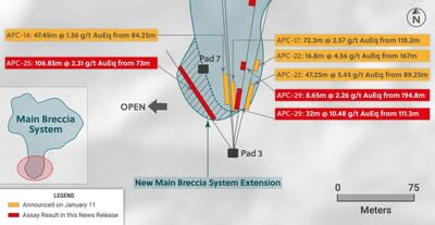
Drill hole APC-29 intercepted the highest grade near-surface copper-silver-gold mineralization encountered to date at the Main Breccia system at the Apollo target (“Apollo”) yielding 32 metres @ 10.48 g/t gold equivalent from 80 metres vertical. This hole was designed to test directly below where the Main Breccia system daylights at surface in the southern part of the system and to follow up on recently announced results for hole APC-22, which intersected 47.25 metres @ 5.45 g/t gold equivalent (see press release dated January 11, 2023). Further down-hole in APC-29, a broad zone of mineralization was encountered averaging 214.4 metres @ 1.04 g/t gold equivalent. APC-29 had to be abandoned short of target depth due to a fault while still in mineralization with the final 0.5 metre sample assaying 1.72 g/t gold, 39 g/t silver and 0.1% copper.
Drill hole APC-25 was designed as a step out hole along strike of the near surface high-grade zone of mineralization and intersected 106.85 metres @ 2.31 g/t gold equivalent starting at 65 metres vertical below surface. As a result, APC-25 has confirmed a shallow, westward expansion to the Main Breccia system and an apparent thickening to the high-grade near surface mineralized zone as the system is traced to the west.
Hole APC-26 was drilled to the northeast from Pad 4 and confirmed continuity of mineralization in that direction returning 136.9 metres @ 1.51 g/t gold equivalent contained within 311.2 metres at 1.04 g/t gold.
The phase II drilling program is underway with three rigs currently operating focused on testing near surface mineralization and expanding the dimensions of the Main Breccia system. Assay results are expected in the near term for the final three holes of the 2022 program, including westwards step-out hole APC-28, which cut more than 600 metres of continuous mineralization. Additionally, the first hole of the Phase II program is now complete, and core has been dispatched to the lab for assaying.
Ari Sussman, Executive Chairman commented: “Not only is the Main Breccia system at Apollo a large, bulk tonnage deposit but it now appears to host an outcropping and shallow zone of high-grade mineralization, which clearly enhances the value of this exciting discovery. Based on surface sampling, the system appears to daylight over an area measuring approximately 150 metres in diameter and remains open for expansion. The Main Breccia system is truly evolving into a brand-new world-class discovery right in the heart of a prolific mining camp with continuous precious metal production dating back more than 500 years.”
TORONTO, Jan. 31, 2023 /CNW/ – Collective Mining Ltd. (TSXV: CNL) (OTCQX: CNLMF) (“Collective” or the “Company”) is pleased to announce assay results from a further three holes drilled into the Main Breccia discovery at the Apollo target (“Apollo”), which is part of the Guayabales project located in Caldas, Colombia. The Main Breccia discovery is a high-grade, bulk tonnage copper-silver-gold porphyry-related system, which owes its excellent metal endowment to multiple phases of mineralization which includes older copper-silver-gold porphyry mineralization and younger, overprinting, precious metal rich sheeted carbonate base metal vein systems.
Details (See Table 1 and Figures 1–6)
Assay results for twenty-eight diamond drill holes have now been announced at Apollo with results for additional holes expected in the near term. This press release announces results of three diamond drill holes with results summarized below.
APC-25 was drilled to the northwest from Pad 3 to a maximum depth of 215.80 metres and intersected a shallow, western extension to the Main Breccia discovery averaging:
106.85 metres @ 2.31 g/t gold equivalent consisting of 0.81 g/t Au, 30 g/t Ag, 0.62% Cu and 30 ppm Mo beginning at 73 metres downhole (65 metres vertical).
The mineralized angular breccia of this intercept contains a sulphide matrix which includes 1.5% to 2.5% chalcopyrite and between 1% and 3% pyrite plus pyrrhotite. The breccia has been overprinted by a zone of carbonate and base metal (sphalerite and galena) veins, which host higher gold grades and returned an interval of 14 metres grading 3.65 g/t gold equivalent. APC-25 is the westernmost hole drilled into the Main Breccia discovery and demonstrates that the mineralization is open and is thickening in this direction. Drill holes have been designed to continue to step-out to the west to expand upon this high grade and near surface mineralization.
APC-26 was drilled northeast from pad 4 and confirms continuity within the Northern Extension Zone of the Main Breccia system, as previously defined in holes APC-17 and APC-22. The hole was drilled to a maximum downhole length of 813.7 metres and intercepted:
311.2 metres @ 1.04 g/t gold equivalent consisting of 0.74 g/t Au, 16 g/t Ag, 0.05% Cu and 10 ppm Mo from 415 metres down hole.
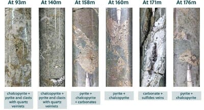
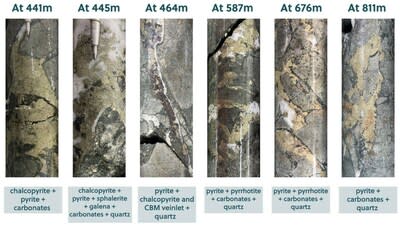
Gold and silver mineralization relates to sulphides hosted within the angular breccia matrix including pyrite (1%-3%), pyrrhotite (1%-2%) and chalcopyrite (0.5%-1%). A higher-grade sub-zone was encountered within the mineralized intercept averaging 136.9 metres at 1.51 g/t gold equivalent and is characterized by an increase in overprinting low and intermediate sulphidation, carbonate base metal (“CBM”) vein material including visible sphalerite and galena.
APC-29 was drilled to the north-northeast from Pad 3 to a maximum depth of 644.8 metres and intercepted three mineralized zones before the hole was abandoned short of target depth due to a complicated fault structure. The two shallow zones within this hole are located directly beneath mineralized surface outcrops with the initial 32.0 metre intercept of mineralization beginning at 111.3 metres downhole (80 metres vertical), and the second 8.65 metre mineralized zone starting at 194.8 metres downhole (143 metres vertical). These high-grade gold, silver, and copper shallow zones of mineralization are hosted within a matrix of angular quartz diorite breccia with the sulphide component consisting of chalcopyrite (0.5%-2%), pyrite (0.5%-2%) and pyrrhotite (0.5-1%). Finally, the third zone, which starts at 343.8 metres downhole (318 metres vertical) intersected more 301 metres of continuous mineralization including a higher-grade subzone over 214.4 metres. The sulphide mineralization within the breccia matrix of this intercept contained pyrrhotite (0.5%-2.5%), pyrite (1%-3%) and multiple zones of sheeted CBM vein material, which are predominantly sphalerite rich with minor galena. The following intercepts are summarized from APC-29:
32.00 metres @ 10.48 g/t gold equivalent consisting of 9.23 g/t Au, 60 g/t Ag, 0.44% Cu and 30 ppm Mo from 89.25 metres downhole (80 metres vertical depth).
8.65 metres @ 2.26 g/t gold equivalent consisting of 0.57 g/t Au, 82 g/t Ag, 0.27% Cu and 10 ppm Mo from 194.80 metres downhole (143 metres vertical depth).
214.40 metres @ 1.04 gold equivalent consisting of 0.77 g/t Au, 14 g/t Ag, 0.05% Cu and 10 ppm Mo from 343.80 metres downhole (318 metres vertical depth), which includes 98.20 metres @ 1.26 g/t gold equivalent.
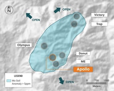
The Company’s Phase II, 2023 program is well underway with two rigs focused on drilling near surface, high grade mineralization below mineralized outcrops in the southern and central areas of the Main Breccia system while simultaneously targeting expansion to the overall dimensions of the system to the west, northwest, north and northeast. Furthermore, a new drill pad (pad 8) has been constructed 150 south of the southernmost modelled boundary of the Main Breccia system at Apollo and reconnaissance drilling is underway to test a recently discovered porphyry target.
The Apollo target area, as defined to date by surface mapping, rock sampling and copper and molybdenum soil geochemistry, covers a 1,000 metres X 1,200 metres area. The Apollo target area hosts the Company’s Main Breccia discovery and multiple additional untested breccia, porphyry and vein targets. The overall Apollo target area also remains open for further expansion.
Table 1: Apollo Target Assays Results for Holes APC-25, APC-26 and APC-29
HoleID
From (m)
To (m)
Intercept (m)
Au (g/t)
Ag (g/t)
Cu %
Mo %
AuEq(g/t) *
CuEq(%) *
APC-25
73.00
179.85
106.85
0.81
30
0.62
0.003
2.31
1.26
Incl.
111.00
125.00
14.00
2.00
35
0.75
0.005
3.65
2.00
APC-26
415.00
726.20
311.20
0.74
16
0.05
0.001
1.04
incl.
415.00
551.90
136.90
1.14
20
0.06
0.001
1.51
APC-29
111.30
143.30
32.00
9.23
60
0.44
0.003
10.48
and
194.80
203.45
8.65
0.57
82
0.27
0.001
2.26
and
343.80
644.80
301.00
0.63
14
0.05
0.001
0.90
Incl.
343.80
558.20
214.40
0.77
14
0.05
0.001
1.04
Incl.
460.00
558.20
98.20
1.26
15
0.04
0.001
1.51
* AuEq (g/t) is calculated as follows: (Au (g/t) x 0.95) + (Ag g/t x 0.016 x 0.95) + (Cu (%) x 1.83 x 0.95)+ (Mo (%)*9.14 x 0.95) and CuEq (%) is calculated as follows: (Cu (%) x 0.95) + (Au (g/t) x 0.51 x 0.95) + (Ag (g/t) x 0.01 x 0.95)+ (Mo(%)x 3.75 x 0.95) utilizing metal prices of Cu – US$4.00/lb, Ag – $24/oz Mo US$20.00/lb and Au – US$1,500/oz and recovery rates of 95% for Au, Ag, Mo and Cu. Recovery rate assumptions are speculative as no metallurgical work has been completed to date.
** A 0.2 g/t AuEq cut-off grade was employed with no more than 15% internal dilution. True widths are unknown, and grades are uncut.
Figure 1: Plan View of the Main Breccia System at Apollo Highlighting Drill Holes APC-25, APC-26 and APC-29 (CNW Group/Collective Mining Ltd.)
Figure 2: Up Close View of Drill Holes Intersecting the Shallow, High-Grade Southern Zone Within the Main Breccia System at Apollo (CNW Group/Collective Mining Ltd.)
Figure 3: Plan View of the Guayabales Project Highlighting the Apollo Target (CNW Group/Collective Mining Ltd.)
To see our latest corporate presentation and related information, please visit www.collectivemining.com
Founded by the team that developed and sold Continental Gold Inc. to Zijin Mining for approximately $2 billion in enterprise value, Collective Mining is a copper, silver and gold exploration company based in Canada, with projects in Caldas, Colombia. The Company has options to acquire 100% interests in two projects located directly within an established mining camp with ten fully permitted and operating mines.
The Company’s flagship project, Guayabales, is anchored by the Apollo target, which hosts the large-scale, bulk-tonnage and high-grade copper, silver and gold Main Breccia discovery. The Company’s near-term objective is to continue with expansion drilling of the Main Breccia discovery while increasing confidence in the highest-grade portions of the system.
Management, insiders and close family and friends own nearly 35% of the outstanding shares of the Company and as a result, are fully aligned with shareholders. The Company is listed on the TSXV under the trading symbol “CNL” and on the OTCQX under the trading symbol “CNLMF”.
Qualified Person (QP) and NI43-101 Disclosure
David J Reading is the designated Qualified Person for this news release within the meaning of National Instrument 43-101 (“NI 43-101”) and has reviewed and verified that the technical information contained herein is accurate and approves of the written disclosure of same. Mr. Reading has an MSc in Economic Geology and is a Fellow of the Institute of Materials, Minerals and Mining and of the Society of Economic Geology (SEG).
Technical Information
Rock and core samples have been prepared and analyzed at SGS laboratory facilities in Medellin, Colombia and Lima, Peru. Blanks, duplicates, and certified reference standards are inserted into the sample stream to monitor laboratory performance. Crush rejects and pulps are kept and stored in a secured storage facility for future assay verification. No capping has been applied to sample composites. The Company utilizes a rigorous, industry-standard QA/QC program.
Information Contact:
Follow Executive Chairman Ari Sussman (@Ariski) and Collective Mining (@CollectiveMini1) on Twitter
FORWARD-LOOKING STATEMENTS
This news release contains certain forward-looking statements, including, but not limited to, statements about the drill programs, including timing of results, and Collective’s future and intentions. Wherever possible, words such as “may”, “will”, “should”, “could”, “expect”, “plan”, “intend”, “anticipate”, “believe”, “estimate”, “predict” or “potential” or the negative or other variations of these words, or similar words or phrases, have been used to identify these forward-looking statements. These statements reflect management’s current beliefs and are based on information currently available to management as at the date hereof.
Forward-looking statements involve significant risk, uncertainties, and assumptions. Many factors could cause actual results, performance, or achievements to differ materially from the results discussed or implied in the forward-looking statements. These factors should be considered carefully, and readers should not place undue reliance on the forward-looking statements. Although the forward-looking statements contained in this news release are based upon what management believes to be reasonable assumptions, Collective cannot assure readers that actual results will be consistent with these forward-looking statements. These forward-looking statements are made as of the date of this news release, and Collective assumes no obligation to update or revise them to reflect new events or circumstances, except as required by law.
Neither the TSXV nor its Regulation Services Provider (as that term is defined in the policies of the TSXV) accepts responsibility for the adequacy or accuracy of this news release.
Vancouver, British Columbia–(Newsfile Corp. – January 30, 2023) – Dolly Varden Silver Corporation (TSXV: DV) (OTCQX: DOLLF) (the “Company” or “Dolly Varden“) is pleased to announce drill results from the 100%-owned Homestake Ridge property in BC’s Golden Triangle.
Highlights from the Homestake Main Deposit include*:
HR22-324: 4.32 g/t Au and 76 g/t Ag over 22.50 meters including 19.42 g/t Au and 375 g/t Ag over 4.50 meters
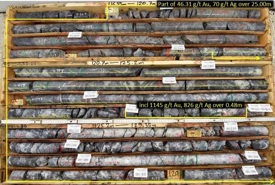
HR22-333: 46.31 g/t Au, 70 g/t Ag and 0.19% Cu over 25.00 meters including 1,145 g/t Au, 826 g/t Ag and 0.51% Cu over 0.48 meters
HR22-336: 6.19 g/t Au and 1,844 g/t Ag over 3.90 meters and 6.37 g/t Au, 29 g/t Ag and 1.51% Cu over 6.00 meters
HR22-338: 4.16 g/t Au, 21 g/t Ag and 1.42% Cu over 5.10 meters including 20.80 g/t Au, 115 g/t Ag and 11.60% Cu over 0.50 meters
HR22-345: 8.73 g/t Au and 12 g/t Ag over 29.54 meters, including 260 g/t Au, 102 g/t Ag over 0.70 meters
HR22-359: Three individual higher grade zones grading; 49.49 g/t Au over 1.52m, 24.00 g/t Au over 0.70m and 46.20 g/t Au over 0.50m within a 40.50 meter interval
* Intervals are core length; estimated true widths vary from 80 to 90% of core length interval, assays are uncut
Highlights from the Homestake Silver Deposit include*:
HR22-349: 211 g/t Ag over 3.50 meters, and 688 g/t Ag over 0.80 meters
HR22-357: Three individual higher grade silver intersects grading; 1,185 g/t Ag over 0.50m, 816 g/t Ag over 0.50m and 1,085 g/t Ag over 0.50m within a 129m wide structural corridor
HR22-361: 2,500 g/t Ag, 15.04 g/t Au and 0.17% Cu over 1.20 meters
HR22-362: 1,252 g/t Ag, 0.81 g/t Au and 0.14% Cu over 2.50 meters, including 3,330 g/t Ag, 0.75 g/t Au and 0.38% Cu over 0.75m
HR22-365: 469 g/t Ag over 2.70 meters including 1,040 g/t Ag over 0.65 meters
* Intervals are core length; estimated true widths vary from 70 to 90% of core length interval, assays are uncut
“Dolly Varden Silver’s initial drilling at the Homestake Main Deposit has returned consistent mineralized intervals with some of the highest grades of gold with silver reported from the Property to date, but also the entire Golden Triangle during the 2022 drilling season,” said Shawn Khunkhun, President and CEO. “Coupled with the exceptional grades and thicknesses of silver mineralization encountered in step-out holes at the Wolf and Kitsol Deposits, we are demonstrating the impressive precious metal endowment and potential of the Kitsault Valley trend.”
The objective of drilling during 2022 at the Homestake Main and Homestake Silver deposits was to expanded multiple, subparallel mineralized zones and to upgrade Inferred Mineral Resources. A total of 41 holes for 10,472 meters were completed at the Homestake Main Deposit, 12 holes for 6,076 meters were completed at the Homestake Silver Deposit and 3 additional exploration holes for 1,900 meters were completed along the Homestake Ridge Trend during the 2022 season.
Figure 1. Homestake Ridge Deposits within Dolly Varden’s Kitsault Valley Trend.
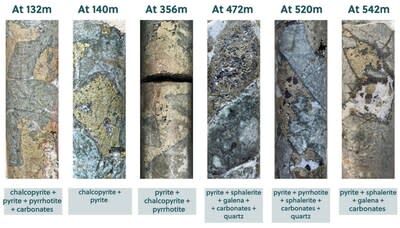
The Homestake Ridge deposits are interpreted as structurally-controlled, multi-phase epithermal vein and breccia systems hosted in early Jurassic-age Hazelton Group volcanic rocks. Mineralization consists primarily of pyrite and chalcopyrite in a breccia matrix within a silica breccia vein system, locally with native gold, silver and electrum. (see Figure 3). The northwestern strike of the main Homestake structural trend hosts multiple, subparallel internal structures that are interpreted to form the controls for high-grade gold shoots within a broader interval of mineralization at the Homestake Main deposit. The main structural corridor dips steeply to the northeast (see Figure 4 to 6).
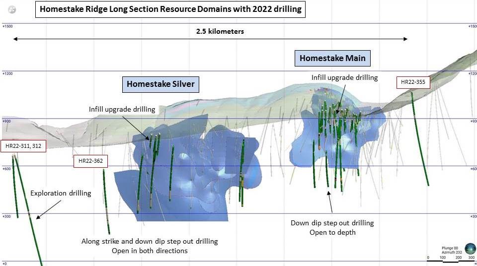
Figure 2. Homestake Main and Homestake Silver Long Section (looking west) with 2022 drilling highlighted.
The results from Homestake Main are primarily infill drilling from areas of current Inferred Mineral Resources and suggest that the higher-grade gold-silver shoots may be more extensive than previously interpreted. In addition, the drilling has generated new targets down-dip the Homestake Main deposit along the projected plunge of the higher grade shoots that are wide open for expansion. Oriented core was used on all drill holes on the project and this detailed structural data is also being integrated in to the geological model to further increase confidence.
Four of the drill holes at Homestake Main were drilled below the Mineral Resource domains to test for down dip extensions. Drill holes HR22-326, 329, 351 and 354 all intersected the structures that host gold mineralization below the resource.
One step out drill hole, HR22-355, was drilled along trend and approximately 250m north of Homestake Main. Alteration associated with the main deposit was encountered with minor brecciation returning anomalous pathfinder elements as seen in the upper levels of the mineralization system at the Homestake Main Deposit indicating the system continues to the north.
Complete Assay results for the second batch of drilling results from Homestake Main are in Table 1.
Figure 3. Drill hole HR22-333 from the Homestake Main deposit showing breccia vein style mineralization.
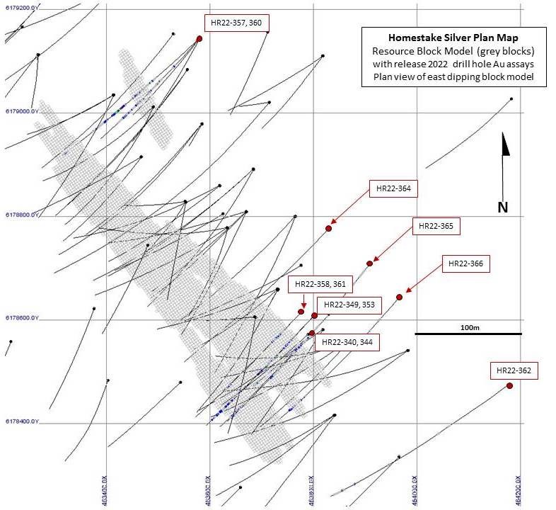
The 2022 drilling at the Homestake Silver Deposit area was a combination of step out holes below the primarily Inferred Mineral Resource as well as some infill drilling designed to convert Inferred resources to Indicated classification. Six infill drill holes, HR22-340, 344, 349, 353, 358 and 361, were collared off three drill pads at the southern end of the deposit (see Figure 8). The mineralization encountered in these holes is consistent with previous drilling.
Expansion drill Holes HR22-364, 365 and 366 targeted the south end while HR22-357 and 360 in the northern end of Homestake Silver testing below several of the resource domains. Drilling intersected silver mineralization (see figure 4) within multiple vein stockwork zones extending the zones to depth. These areas remain open down dip.
Figure 4. Drill hole HR22-366, 473m depth, down dip step out from the Homestake Silver deposit showing Native Silver in breccia vein style mineralization.
Step out drill hole HR22-362, located approximately 200m down dip and along the targeted projection of a Homestake Silver resource domain intersected vein breccia over 2.50m core length grading 1,252 g/t Ag, including 0.75m grading 3,330 g/t Ag. Relatively little drilling has been completed at Homestake Silver and with these step out mineralized intersections the expansion potential to depth and along strike has been demonstrated.
Complete Assay results for the 2022 Homestake Silver drilling are in Table 2.
Homestake Trend Exploration
Two new areas within the Homestake Trend were tested with three drill holes. Drill holes HR22-311 and 312 were collared 425m to the south of the Homestake Silver Deposit to test below sedimentary cover rocks (see Figure 2). Although alteration of the volcanic rock below the sediment cover was present, no significant mineralization was encountered. Further geophysics will be completed over this area to aid in targeting the southern projection of the Homestake Ridge structural corridor below the sediment cover.
Drill hole HR22-363 was drilled 1.2 kilometers to the east of Homestake Main to test a dominant Northeast trending controlling structure within the centre of the valley. No significant mineralization was encountered within the structure in that area.
Plans, Sections and Tables
Figure 5. Homestake Main Plan View highlighting 2022 Infill and Step out drilling (red collars) with Current Mineral Resource block model, primarily of Inferred Classification.
Figure 8. Homestake Silver Plan View highlighting 2022 Step out and Infill drilling (red collars) with Current Mineral Resource block model, primarily of Inferred Classification.
Table 1. Complete Drill Hole Assays from the Homestake Main Deposit Infill drilling
Hole ID
From (m)
To (m)
Length* (m)
Au (g/t)**
Ag (g/t)**
Cu (%)
HR22-324
152.00
174.50
22.50
4.32
76
NSV
including
170.00
174.50
4.50
19.42
375
NSV
including
171.96
172.40
0.44
166
984
NSV
HR22-326
451.00
472.80
21.80
0.47
NSV
NSV
including
461.00
463.00
2.00
3.00
NSV
NSV
HR22-329
413.46
450.55
37.09
0.73
NSV
NSV
including
418.00
422.00
4.00
4.03
6
NSV
including
423.00
424.00
1.00
1.62
9
NSV
HR22-332
252.40
265.20
12.80
0.33
NSV
0.18
including
256.50
258.00
1.50
0.81
11
1.09
including
344.50
345.50
1.00
1.39
16
NSV
and
393.00
403.25
10.25
0.79
NSV
NSV
including
397.50
400.50
3.00
2.30
40
NSV
HR22-333
92.00
105.00
13.00
1.05
21
NSV
including
98.30
99.08
0.78
13.95
196
NSV
and
117.00
142.00
25.00
46.31
70
0.19
including
120.26
130.10
9.84
111.94
162
0.37
including
124.67
125.15
0.48
1,145
826
0.51
HR22-336
96.30
100.20
3.90
6.19
1,844
NSV
including
96.62
97.00
0.38
3.78
13,855
0.49
and
132.00
157.00
25.00
1.95
NSV
0.38
including
133.00
139.00
6.00
6.37
29
1.51
HR22-338
120.90
126.00
5.10
4.16
21
1.42
including
120.90
121.40
0.50
20.80
115
11.60
including
128.60
129.84
1.24
8.92
52
1.38
and
150.50
159.00
8.50
0.63
5
0.21
including
150.50
151.30
0.80
4.89
28
1.43
and
175.50
178.50
3.00
0.61
17
0.45
including
177.00
177.65
0.65
1.17
43
1.55
HR22-341
84.00
113.00
29.00
2.28
5
0.13
including
96.00
107.00
11.00
5.27
9
0.33
including
102.00
104.00
2.00
14.85
20
0.73
HR22-342
79.32
102.00
22.68
0.80
57
NSV
including
88.31
92.00
3.69
2.95
8
NSV
and
120.00
140.44
20.44
0.57
NSV
NSV
including
121.13
123.70
2.57
2.39
5
0.29
HR22-343
84.50
115.00
30.50
1.15
NSV
NSV
including
92.27
96.80
4.53
1.59
NSV
NSV
including
99.19
103.30
4.11
2.67
5
NSV
including
107.00
109.00
2.00
4.45
15
0.35
HR22-345
95.00
124.54
29.54
8.73
12
0.13
including
115.12
124.54
9.42
26.25
28
0.37
including
120.00
120.70
0.70
260
102
NSV
HR22-346
111.00
126.05
15.05
1.04
NSV
NSV
including
119.75
122.75
3.00
3.47
9
0.37
HR22-347
135.00
156.00
21.00
1.88
NSV
0.04
including
135.00
147.00
12.00
2.57
NSV
0.07
HR22-348
63.00
71.00
8.00
0.16
NSV
NSV
and
80.00
111.00
31.00
1.63
NSV
NSV
including
88.00
100.00
12.00
3.24
NSV
0.14
HR22-350
66.00
128.00
62.00
0.87
NSV
NSV
including
77.00
94.00
17.00
2.05
NSV
NSV
HR22-351
436.00
438.00
2.00
0.36
NSV
NSV
and
473.70
477.50
3.80
0.30
NSV
NSV
HR22-352
172.00
227.00
55.00
1.37
4
0.20
including
178.81
179.81
1.00
53.75
54
2.03
including
202.33
203.33
1.00
3.65
63
4.68
including
211.00
212.45
1.45
1.22
9
0.16
HR22-354
495.00
498.90
3.90
0.12
NSV
NSV
HR22-355 (step out)
645.00
648.50
3.50
0.12
NSV
NSV
and
662.00
666.75
4.75
0.18
NSV
NSV
HR22-356
212.00
218.00
6.00
0.38
NSV
NSV
and
221.00
221.50
0.50
4.32
NSV
NSV
and
291.50
308.00
16.50
0.21
NSV
NSV
HR22-359
49.70
50.20
0.50
0.74
6,420
0.11
and
111.63
113.15
1.52
49.49
50
0.96
and
136.85
137.55
0.70
24.00
76
0.38
and
141.00
141.50
0.50
46.20
6
NSV
*Estimated true widths vary depending on intersection angles and range from 80% to 90% of core lengths ** Assays reported are uncut
Table 2. Completed Drill Hole Assays from the Homestake Silver Deposit step out and Infill drilling
Hole ID
From (m)
To (m)
Length* (m)
Au (g/t)**
Ag (g/t)**
Cu (%)
HR22-340
46.00
56.00
10.00
NSV
97
NSV
HR22-344
81.00
82.00
1.00
NSV
112
NSV
and
152.00
153.00
1.00
NSV
103
NSV
and
166.00
167.00
1.00
0.39
NSV
NSV
and
197.75
204.75
7.00
0.13
65
NSV
including
197.75
198.50
0.75
0.13
146
NSV
and
408.00
410.00
2.00
0.14
72
NSV
HR22-349
153.00
156.50
3.50
NSV
211
0.12
and
159.20
160.00
0.80
NSV
688
NSV
and
325.80
329.00
3.20
0.12
210
NSV
and
337.00
341.00
4.00
0.50
287
NSV
and
355.47
356.18
0.71
0.10
434
NSV
and
361.50
362.80
1.30
NSV
151
NSV
HR22-353
239.22
256.00
16.78
NSV
119
NSV
including
239.22
243.27
4.05
NSV
242
NSV
including
253.79
256.00
2.21
0.17
154
NSV
HR22-357
194.38
195.50
1.12
0.16
318
NSV
and
200.00
200.50
0.50
NSV
151
NSV
and
206.60
209.30
2.70
0.08
506
NSV
including
206.60
207.10
0.50
0.11
1,185
NSV
and
239.00
239.50
0.50
0.11
816
NSV
and
298.70
299.20
0.50
NSV
1,085
0.18
and
315.60
316.15
0.55
0.17
585
NSV
and
335.10
335.90
0.80
0.30
351
NSV
HR22-358
110.27
111.92
1.65
NSV
132
NSV
and
136.69
137.10
0.41
NSV
192
NSV
and
250.77
251.17
0.40
0.08
386
NSV
and
326.61
327.12
0.51
0.63
161
NSV
and
331.00
332.00
1.00
0.07
215
NSV
HR22-360
205.40
206.00
0.60
0.08
339
NSV
and
229.00
229.50
0.50
0.07
425
NSV
and
243.75
244.25
0.50
NSV
136
NSV
and
278.25
279.25
1.00
NSV
148
NSV
and
315.00
317.00
2.00
NSV
310
NSV
and
328.50
329.50
1.00
0.10
488
NSV
and
331.00
332.70
1.70
0.13
690
NSV
and
336.00
336.50
0.50
0.60
1,270
NSV
and
337.45
341.70
4.25
0.40
251
NSV
and
396.00
399.00
3.00
2.31
39
NSV
and
444.00
446.00
2.00
0.68
NSV
NSV
HR22-361
165.17
165.63
0.46
NSV
599
NSV
and
213.33
213.65
0.32
0.37
99
NSV
and
226.10
227.30
1.20
15.04
2,500
0.17
and
317.01
317.41
0.40
2.07
45
0.44
HR22-362
633.00
635.50
2.50
0.81
1,252
0.14
including
634.00
634.75
0.75
2.24
3,330
0.38
HR22-364
486.75
488.60
1.85
0.16
15
NSV
HR22-365
184.70
186.85
2.15
NSV
187
NSV
and
190.75
193.45
2.70
NSV
469
NSV
including
192.30
192.95
0.65
NSV
1,040
NSV
and
512.00
512.85
0.85
0.31
98
NSV
HR22-366
472.70
473.27
0.57
0.70
2,760
0.06
*Estimated true widths vary depending on intersection angles and range from 70% to 90% of core lengths ** Assays reported are uncut
Table 3. Drill Hole Collars for 2022 Homestake Main Deposit Area Drilling (this release)
Hole ID
Easting UTM83 (m)
Northing UTM83 (m)
Elev. (m)
Azimuth
Dip
Length (m)
HR22-324
462956
6179462
956
225
-80
201.00
HR22-326
463126
6179555
903
215
-72
472.50
HR22-329
463126
6179555
903
232
-72
495.00
HR22-332
462965
6179544
922
240
-73
402.00
HR22-333
463089
6179383
982
225
-47
210.00
HR22-336
463034
6179363
1009
225
-76
186.00
HR22-338
463034
6179363
1009
240
-56
186.00
HR22-341
462902
6179443
961
220
-48
120.00
HR22-342
462995
6179395
996
225
-65
198.00
HR22-343
462902
6179443
961
220
-50
150.00
HR22-345
462919
6179389
1007
225
-66
132.00
HR22-346
462866
6179514
943
225
-50
180.00
HR22-347
462866
6179514
943
225
-60
192.00
HR22-348
462919
6179389
1007
225
-50
111.00
HR22-350
462919
6179389
1007
200
-45
132.00
HR22-351
463323
6179506
854
225
-45
522.00
HR22-352
463132
6179416
949
200
-55
351.00
HR22-354
463314
6179608
842
226
-45
502.00
HR22-355
462865
6179922
1066
245
-60
682.00
HR22-356
463050
6179452
956
255
-74
399.00
HR22-359
462919
6179389
1007
160
-45
288.00
Table 4. Drill Hole Collars for 2022 Homestake Silver Deposit Area Drilling
Hole ID
Easting UTM83 (m)
Northing UTM83 (m)
Elev. (m)
Azimuth
Dip
Length (m)
HR22340
463802
6178573
801
223
-46
360.00
HR22344
463802
6178573
801
223
-56
435.00
HR22349
463805
6178612
793
223
-45
435.00
HR22353
463805
6178612
793
223
-57
477.00
HR22358
463780
6178621
803
223
-50
467.00
HR22361
463780
6178621
803
223
-56
390.00
HR22357
463578
6179147
834
220
-55
528.00
HR22360
463578
6179147
834
230
-50
600.00
HR22362
464180
6178462
716
235
-50
681.00
HR22364
463833
6178779
763
223
-50
600.00
HR22365
463912
6178711
749
223
-50
531.00
HR22366
463964
6178647
745
220
-53
570.00
Table 5. Drill Hole Collars for 2022 Homestake Exploration Drilling
Hole ID
Easting UTM83 (m)
Northing UTM83 (m)
Elev. (m)
Azimuth
Dip
Length (m)
HR22311
464460
6177976
714
250
-50
903.00
HR22312
464460
6177976
714
230
-55
520.00
HR22363
464217
6179802
840
190
-75
471.00
The Company Engages Gold Standard Media LLC
The Company has engaged internet marketing and advertising company, Gold Standard Media, LLC (“GSM”), to prepare email marketing campaigns, landing pages, advertisements, and other related services to assist the Company in raising public awareness of the Company and enhance its online presence.
GSM is a limited liability company existing under the laws of the State of Texas with an office at 723 W, University Ave. #110-283 Georgetown Texas. GSM uses affiliated entities such as Future Money Trends and Portfolio Wealth Global LLC for the purpose of these marketing activities. Under the terms of the agreement GSM will be paid US$125,000 for a 12 month period.
Quality Assurance and Quality Control
The Company adheres to CIM Best Practices Guidelines for exploration related activities conducted on its property. Quality Assurance and Quality Control (QA/QC) procedures are overseen by the Qualified Person.
Dolly Varden QA/QC protocols are maintained through the insertion of certified reference material (standards), blanks and field duplicates within the sample stream. Drill core is cut in-half with a diamond saw, with one-half placed in sealed bags and shipped to the laboratory and the other half retained on site. Third party laboratory checks on 5% of the samples are carried out as well. Chain of custody is maintained from the drill to the submittal into the laboratory preparation facility.
Analytical testing was performed by ALS Canada Ltd. in North Vancouver, British Columbia. The entire sample is crushed to 70% minus 2mm (10 mesh), of which a 500 gram split is pulverized to minus 200 mesh. Multi-element analyses were determined by Inductively Coupled Plasma Mass Spectrometry (ICP-MS) for 48 elements following a 4-acid digestion process. High grade silver testing was determined by Fire Assay with either an atomic absorption, or a gravimetric finish, depending on grade range. Au is determined by Fire Assay on a 30g split.
Qualified Person
Rob van Egmond, P.Geo., Vice-President Exploration for Dolly Varden Silver, the “Qualified Person” as defined by NI43-101 has reviewed, validated and approved the scientific and technical information contained in this news release and supervises the ongoing exploration program for Dolly Varden on the Kitsault Valley Project.
About Dolly Varden Silver Corporation
Dolly Varden Silver Corporation is a mineral exploration company focused on advancing its 100% held Kitsault Valley Project (which combines the Dolly Varden Project and the Homestake Ridge Project) located in the Golden Triangle of British Columbia, Canada, 25kms by road to tide water. The 163 sq. km. project hosts the high-grade silver and gold resources of Dolly Varden and Homestake Ridge along with the past producing Dolly Varden and Torbrit silver mines. It is considered to be prospective for hosting further precious metal deposits, being on the same structural and stratigraphic belts that host numerous other, on-trend, high-grade deposits, such as Eskay Creek and Brucejack. The Kitsault Valley Project also contains the Big Bulk property which is prospective for porphyry and skarn style copper and gold mineralization, similar to other such deposits in the region (Red Mountain, KSM, Red Chris).
Forward-Looking Statements
This release may contain forward-looking statements or forward-looking information under applicable Canadian securities legislation that may not be based on historical fact, including, without limitation, statements containing the words “believe”, “may”, “plan”, “will”, “estimate”, “continue”, “anticipate”, “intend”, “expect”, “potential”, and similar expressions. Forward-looking statements involve known and unknown risks, uncertainties, and other factors which may cause the actual results, performance, or achievements of Dolly Varden to be materially different from any future results, performance, or achievements expressed or implied by the forward-looking statements. Forward-looking statements or information in this release relates to, among other things, the 2022 drill program at the Kitsault Valley Project, the results of previous field work and programs and the continued operations of the current exploration program, interpretation of the nature of the mineralization at the project and that that the mineralization on the project is similar to Eskay and Brucejack, results of the mineral resource estimate on the project, the potential to grow the project, the potential to expand the mineralization and our beliefs about the unexplored portion of the property.
These forward-looking statements are based on management’s current expectations and beliefs and assume, among other things, the ability of the Company to successfully pursue its current development plans, that future sources of funding will be available to the company, that relevant commodity prices will remain at levels that are economically viable for the Company and that the Company will receive relevant permits in a timely manner in order to enable its operations, but given the uncertainties, assumptions and risks, readers are cautioned not to place undue reliance on such forward-looking statements or information. The Company disclaims any obligation to update, or to publicly announce, any such statements, events or developments except as required by law.
For additional information on risks and uncertainties, see the Company’s most recently filed annual management discussion & analysis (“MD&A“) and management information circular dated January 21, 2022 (the “Circular“), both of which are available on SEDAR at www.sedar.com. The risk factors identified in the MD&A and the Circular are not intended to represent a complete list of factors that could affect the Company.
Neither the TSX Venture Exchange nor its Regulation Services Provider (as that term is defined in the policies of the TSX-V) accepts responsibility for the adequacy or accuracy of this news release.
Silver is a precious metal that has been used for thousands of years in various forms of currency, jewelry, and industrial applications. However, the demand for silver has increased in recent years due to its use in new technologies such as Electric cars, solar panels and electronic devices. As a result, this raises concerns about the possibility of a silver deficit, where demand for the metal exceeds supply. This raises the question of whether or not a silver deficit would have any significant impact on the global economy and the price of silver.
Watch this video on Do Silver Deficits Matter?, then please share with your friends and family on social media and use the caption: Do Silver Deficits Matter?.
I’ve Been Helping My Subscribers Weather the Current Economic Mess. Now I Invite You to Join My Growing Circle of Successful Investors.
The Morgan Report is all about YOU and how you can build and preserve Wealth for generations to come. We know it can sometimes seem a daunting task to protect your assets and preserve or grow your wealth. Over 15 years ago, a small group of us started The Morgan Report and formed an exclusive membership organization to promote personal freedom, an honest money system, free market wealth accumulation, and asset protection.
Thus was born The Morgan Report – since then we’ve helped 11,000-plus members scattered over the globe in every continent and over 100,000+ e-newsletter subscribers have read our weekly e-newsletter — This Week’s View from The Morgan Report.
Through our publication, The Morgan Report, we provide you with ways to achieve greater financial security and wealth in all sorts of environments.
Learn more and become an insider for The Morgan Report, click the link below…
Because there is a 100% failure rate of ALL fiat money throughout history, you will learn what to do by obtaining your Free Report. Just enter your first name, your primary email address and click the Get Special Report button below.
Our mission statement reads…
“To teach and empower people to understand the benefits of an honest monetary system.”
Today’s monetary system is based upon a lie. The lie is that you can get something for nothing, or perhaps more simply stated, wealth can be printed. History has shown throughout 5000 years that whenever a country has tried to maintain this illusion (lie), failure has been the result. We invite you to learn more about what The Morgan Report can do for you. Click on the Learn More About The Morgan Report button now! Learn More About The Morgan Report *
Prices of silver could hit a nine-year high of $30 per ounce this year — possibly outpacing gold prices.
The last time spot silver touched $30 levels per ounce was in February 2013, according to closing price data from Refinitiv.
Insufficient supplies of silver as well as its tendency to be a better performer than gold in periods of high inflation are key drivers supporting the outlook, analysts told CNBC.
“Silver has historically delivered gains of close to 20% per annum in years inflation is high. Given that track record, and how cheap silver remains relative to gold, it wouldn’t surprise to see silver head towards $30 per ounce this year, though that will likely offer significant resistance,” said Janie Simpson, managing director at ABC Bullion.
Spot silver prices notched a record high of $49.45 in 1980 against the backdrop of a 13.5% inflation rate, up from around $4 in 1976, when the rate of inflation was cooler at 5.7%.
The precious metal last traded $24.02 per ounce, against the backdrop of an inflation rate of 6.5%.
Silver shortage
“Silver is in a shortage… and there is a notable drawdown in the available physical stocks held in New York and London’s physical hubs, more so than seen in gold,” said Nicky Shiels, head of metals strategy at precious metals company MKS PAMP.
Shiels added that silver is expected to post deficits of more than 100 million ounces over the next five years, with industrial demand spurring the tight supply.
“The largest segment of silver demand is industrial, [which equates] to almost 50% of total demand,” she said, calling for a base case of silver prices to climb to $28, with a bullish case of $30 or more.
I’m very bullish on gold, but I’m even more bullish on silver.
Randy Smallwood
PRESIDENT OF WHEATON PRECIOUS METALS
That demand is expected to grow more than 15% over the next five years, he said, hinging on accelerated industrial demand from automotive and electronics applications.
Silver is a material commonly used in the manufacturing of automobiles, solar panels, jewelry and electronics.
No silver lining for silver supplies
“We hit peak silver supply back about five, six years ago. Silver production on a worldwide basis has actually been dropping, and we’re not seeing as much silver produced from the mines,” said Randy Smallwood, president of Wheaton Precious Metals.
According to trade group The Silver Institute, the supply of silver from mine production in 2022 was 843.2 million ounces, which was still shy of the decade’s peak of 900 million ounces in 2016.
The supply of silver, which is largely produced as a byproduct of lead-zinc, copper and gold mines, does not generally respond as quickly to demand.
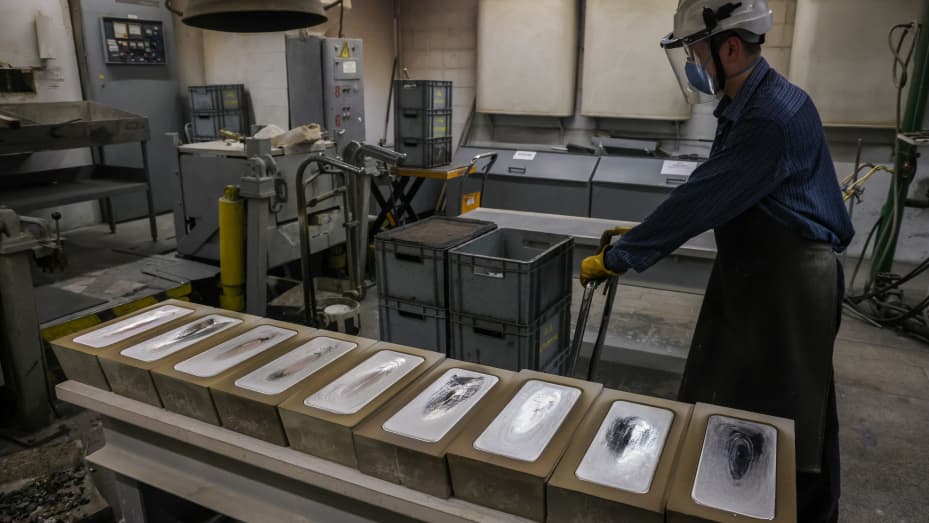
Freshly cast 30 kilogram silver ingots cooling in their molds at the JSC Krastsvetmet non-ferrous metals plant in Krasnoyarsk, Russia, on Monday, July 12, 2021.
Andrey Rudakov | Bloomberg | Getty Images
“When silver prices go up, it’s not like the silver mines can increase production, because the silver mines only supply about 25% of the silver,” Smallwood said, adding that the market often relies on the lead-zinc mines to satisfy the higher demand.
However, he maintained that while it wouldn’t be surprising to see silver touch $30 per ounce, he does not think that price will hold. He calls for prices to “stay comfortably over $20 per ounce.”
“I’m very bullish on gold, but I’m even more bullish on silver,” Smallwood said.
‘Headwind for silver’?
However, recession fears could lead to softer industrial demand, which may cause silver prices to drop as low as $18 per ounce, according to MKS PAMP.
The biggest risk to silver prices is if inflation falls away faster than expected, Pallion’s Simpson seconded.
“If the Fed continues to tighten, and if inflation falls away more rapidly than the market expects, that will be a headwind for silver,” she said, “especially if the economy heads into a recession, given the large share of silver demand tied to industrial output.”
VANCOUVER, BC / ACCESSWIRE / January 25, 2023 / Stillwater Critical Minerals (TSX.V:PGE)(OTCQB:PGEZF)(FSE:5D32) (the “Company” or “SWCM”) is pleased to report a 62% increase in the updated independent National Instrument 43-101 (“NI 43-101”) mineral resource estimate (the “2023 Resource”) for its 100%-owned Stillwater West platinum group element, nickel, copper, cobalt, and gold (“PGE-Ni-Cu-Co + Au”) project in Montana, USA. The study, which was completed by SGS Geological Services (“SGS”), showed significant increases in tonnage and contained metal at both a bulk tonnage 0.20% nickel equivalent (“NiEq”) cut-off (“Base Case”) and a 0.35% NiEq higher grade bulk tonnage cut-off. A high-grade, selective mining component at a 0.70% NiEq cut-off is presented for the first time.
The Company will host a live webcast on January 31, 2023, at 10am PT | 1pm ET to discuss the Stillwater West project and the 2023 Resource. To register, click here.
2023 Resource Highlights
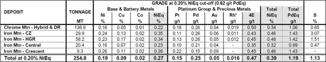
Base Case Inferred mineral resources of 1.6 billion pounds (“Blbs”) of nickel, copper and cobalt and 3.8 million ounces (“Moz”) palladium, platinum, rhodium, and gold (“4E”) in a constrained model totaling 255 million tonnes (“Mt”) at an average grade of 0.39% total estimated recovered NiEq (or 1.19 g/t Palladium Equivalent “PdEq”). See detailed breakdown in Tables 1 and 2, below.
Significant increases in contained metals over the 2021 study at the Base Case 0.20% NiEq cut-off:
Tonnage: 255Mt (62% increase)
Palladium: 2.05Moz (56% increase)
Nickel: 1.05Blbs (52% increase)
Platinum: 1.26Moz (66% increase)
Copper: 499Mlbs (44% increase)
Gold: 395Koz (30% increase)
Cobalt: 91Mlbs (31% increase)
Rhodium: 115Koz (76% increase)
The selective mining high-grade component yielded 11.6Mt at 1.05% Total NiEq (or 3.24 g/t Total PdEq) as 0.56% Ni, 0.33% Cu, 0.03% Co with 0.54 g/t Pd, 0.27 g/t Pt, 0.15 g/t Au and 0.019 g/t Rh. Expansion of this high-grade component results from the addition of high-grade mineralization encountered in the 2021 drill campaign.
Sulphur grades of 1.13% to 6.16% indicate desirable high nickel tenor in sulphide, supporting effective recovery via conventional flotation techniques.
2.27Blbs of chromium has been inventoried. Chromium is defined by the US government as a critical mineral.
Deposits in the 2023 Resource are defined by 156 drill holes from a total of 230 holes drilled on the Stillwater West property and include all holes from the Company’s three campaigns to date.
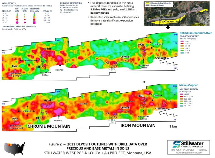
The 2023 Resource is contained within five deposits in the 9-kilometer central area of the project, all of which are open along strike and at depth. Multi-kilometer scale geophysical targets (Figure 1) and metal-in-soil anomalies indicate excellent expansion potential (Figures 2 to 4). Untested anomalies and earlier stage targets extend across much of the 32-kilometer-long Stillwater West project.
An NI 43-101-compliant technical report on the 2023 Resource for the Stillwater West project will be filed on Sedar.com within 45 days.
Michael Rowley, President and CEO stated, “We are very pleased with the expanded 2023 resource, which returned substantial increases in tonnage and contained metals while also increasing the high-grade component. Overall, these increases speak to the fantastic growth potential and under-explored nature of the Stillwater West project, and to our ability to rapidly increase resources in these wide-open deposits with targeted expansion drilling at low discovery costs. Our Stillwater West project, with its world-class endowment of eight critical minerals, is unique in the United States as a district-scale asset located in an active, producing district that has a long history of large-scale critical mineral production. The US government has recognized the importance of critical minerals to both economic and national security interests and is taking increasing action to secure domestic supply of these key metals at a time when we are advancing Stillwater West and demonstrating its potential. Our exceptional team, with multi-decades of experience at both Stillwater and in the parallel layered geology of the Bushveld Igneous Complex, is well-positioned to advance the asset. We look forward to continuing to build on our success and low discovery costs as we finalize our follow up expansion programs for 2023.”
Dr. Danie Grobler, Vice-President of Exploration, commented, “The 2022 field season, with a renewed focus on geology and structure, has contributed to the understanding of the multi-target geometry and mineralization controls within the Ultramafic Series of the Stillwater Complex, as an analogue to the Platreef of the Bushveld Complex. Our advanced understanding of Platreef-style mineralization and ore mineralogy, and our collaboration with Professor Wolfgang Maier at Cardiff University United Kingdom, as well as key staff at the US Geological Survey, has increased our confidence in the stratigraphic and structural models guiding resource estimation. Enhanced continuity and a significant tonnage increase, as well as increased medium and higher-grade categories, is a direct result of this effort. Our 2023 exploration programs will be focused on expansion of these thick zones of mineralized pegmatoidal pyroxenite/peridotite and associated chromites, as well as broad zones of massive to net-textured sulphides near the base of the layered sequence. We are seeing similar metal distribution characteristics when compared to the Platreef, as well as sulfur contents in relation to distance from the footwall contact. Our direct application of the detailed controls to mineralization in the Platreef-style models is guiding us along an exciting path of discovery.”
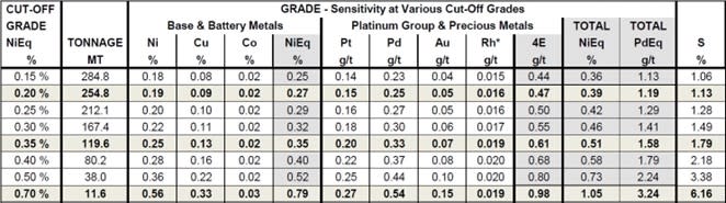
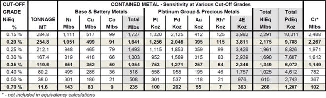
TABLE 1 – Grade and Contained Metal at Various NiEq Cut-off Grades
Stillwater Critical Minerals, Wednesday, January 25, 2023, Press release picture
Stillwater Critical Minerals, Wednesday, January 25, 2023, Press release picture
Stillwater West Inferred Mineral Resource Estimate, January 20, 2023
Notes: 1) In-Pit Inferred Mineral Resources are reported at a base case cut-off grade of 0.20% NiEq. Values in this table reported above and below the cut-off grades are only presented to show the sensitivity of the block model estimates to the selection of cut-off grade. Equivalent grade and contained metal calculations do not include Rhodium values; 2) All figures are rounded to reflect the relative accuracy of the estimate. Totals may not add or calculate exactly due to rounding.
TABLE 2 – BASE CASE – Grade and Contained Metal by Deposit at 0.20% NiEq Cut-Off (Equals 0.62 g/t PdEq) Stillwater West 2023 Inferred Mineral Resource Estimate, January 20, 2023
Stillwater Critical Minerals, Wednesday, January 25, 2023, Press release picture
Stillwater Critical Minerals, Wednesday, January 25, 2023, Press release picture
Notes: 1) No assays shown as – ; 2) equivalent contained metal and grades do not include Rh. See additional notes on page 4.
2023 Exploration Planning
The Company is finalizing 2023 exploration plans with work expected to include extension of the highly effective geophysical surveys and completion of expansion drilling, focused on large, thick zones of mineralized pegmatoidal pyroxenite and peridotite within the resource areas. These zones show direct parallels to the thick Flatreef-style mineralized zones discovered in recent years by Ivanhoe Mines on the Platreef. A second focus for drilling will be to expand on the nickel-rich massive sulphide zones, as well as the very high-grade gold-PGE mineralization within structurally controlled zones.
Metallurgy
Preliminary metallurgical assessments by SWCM returned strong nickel tenor in sulphides drilled by the Company to date. In addition, favorable historic bench-scale metallurgical results completed historically by AMAX at the Iron Mountain target area demonstrate the potential for effective nickel and copper sulphide flotation and PGE recovery. Sample collection for more detailed metallurgical testing is on-going as part of the expanding development of Stillwater West, with a view to including full metallurgical assessment in future studies.
Carbon Capture at Stillwater West
All five deposits in the 2023 Resource contain desirable nickel sulphide mineralization that has been shown to require a much lower environmental footprint in subsequent processing to nickel metal or nickel sulphate in comparison to the laterite nickel ores that dominate global production. As part of SWCM’s commitment to global sustainability initiatives, the Company is also examining the potential for large-scale carbon sequestration with the objective of further reducing and possibly eliminating the carbon footprint of a potential mining operation at Stillwater West.
Preliminary results demonstrate the presence of certain ultramafic minerals that are known to have high capacity to bind carbon dioxide by a natural process known as mineral carbonation. As announced in a news release on September 23, 2021, the Company is continuing its research with Dr. Greg Dipple and his team at ARCA (formerly based at the University of British Columbia, Canada), to assess the capacity of rock samples from Stillwater West to bind carbon dioxide for permanent disposal as part of a potential mining operation. The Company has partnered with Cornell University for more active carbon sequestration methods, as well as hydrometallurgical processing.
This work strongly aligns with SWCM’s Environmental, Social and Governance guidelines and principles, and the incorporation of carbon uptake may bring financial benefits via initiatives such as the 45Q Tax Credit for Carbon Oxide Sequestration that is now in place in the US.
About Stillwater West
Stillwater Critical Minerals is rapidly advancing the Stillwater West PGE-Ni-Cu-Co + Au project towards becoming a world-class source of low-carbon, sulphide-hosted nickel, copper, and cobalt, critical to the electrification movement, as well as key catalytic metals including platinum, palladium and rhodium used in catalytic converters, fuel cells, and the production of green hydrogen. Stillwater West positions SWCM as the second-largest landholder in the Stillwater Complex, with a 100%-owned position adjoining and adjacent to Sibanye-Stillwater’s operating PGE mines in south-central Montana, USA1. The Stillwater Complex is recognized as one of the top regions in the world for PGE-Ni-Cu-Co mineralization, alongside the Bushveld Complex and Great Dyke in southern Africa, which are similar layered intrusions. The J-M Reef, and other PGE-enriched sulphide horizons in the Stillwater Complex, share many similarities with the highly prolific Merensky and UG2 Reefs in the Bushveld Complex. SWCM’s work in the lower Stillwater Complex has demonstrated the presence of large-scale disseminated and high-sulphide battery metals and PGE mineralization, similar to the Platreef in the Bushveld Complex2. Drill campaigns by the Company, complemented by a substantial historic drill database, have delineated five deposits of Platreef-style mineralization across a core 12-kilometer span of the project, all of which are open for expansion into adjacent targets. Multiple earlier-stage Platreef-style and reef-type targets are also being advanced across the remainder of the 32-kilometer length of the project based on strong correlations seen in soil and rock geochemistry, geophysical surveys, geologic mapping, and drilling.
About Stillwater Critical Minerals Corp.
Stillwater Critical Minerals (TSX.V: PGE | OTCQB: PGEZF) is a mineral exploration company focused on its flagship Stillwater West PGE-Ni-Cu-Co + Au project in the iconic and famously productive Stillwater mining district in Montana, USA. With the recent addition of two renowned Bushveld and Platreef geologists to the team, the Company is well positioned to advance the next phase of large-scale critical mineral supply from this world-class American district, building on past production of nickel, copper, and chromium, and the on-going production of platinum group and other metals by neighboring Sibanye-Stillwater. The Platreef-style nickel and copper sulphide deposits at Stillwater West contain a compelling suite of critical minerals and are open for expansion along trend and at depth, with an updated NI 43-101 mineral resource update announced in January 2023.
Stillwater Critical Minerals’ Black Lake-Drayton Gold project adjacent to Treasury Metals’ development-stage Goliath Gold Complex in northwest Ontario is currently under an earn-in agreement with Heritage Mining and the Company also holds the Kluane PGE-Ni-Cu-Co project on trend in Canada‘s Yukon Territory.
Note 1: References to adjoining properties are for illustrative purposes only and are not necessarily indicative of the exploration potential, extent or nature of mineralization or potential future results of the Company’s projects.
Note 2: Magmatic Ore Deposits in Layered Intrusions-Descriptive Model for Reef-Type PGE and Contact-Type Cu-Ni-PGE Deposits, Michael Zientek, USGS Open-File Report 2012-1010.
The classification of the current Mineral Resource Estimate into Inferred is consistent with current 2014 CIM Definition Standards – For Mineral Resources and Mineral Reserves.
All figures are rounded to reflect the relative accuracy of the estimate. Totals may not add or calculate exactly due to rounding.
All Resources are presented undiluted and in situ, constrained by continuous 3D wireframe models, and are considered to have reasonable prospects for eventual economic extraction.
Mineral resources which are not mineral reserves do not have demonstrated economic viability. An Inferred Mineral Resource has a lower level of confidence than that applying to an Indicated Mineral Resource and must not be converted to a Mineral Reserve. It is reasonably expected that the majority of Inferred Mineral Resources could be upgraded to Indicated Mineral Resources with continued exploration.
The update MRE is based on data for 156 surface drill holes representing 29,392 m of drilling, including data for 14 surface drill holes for 5,143 m completed by Stillwater in 2021.
The mineral resource estimate is based on 6 three-dimensional (“3D”) resource models representing the Chrome Mountain (Hybrid and DR), Camp, HGR, Central and Crescent Zones.
Composites of 1.2 to 3.0 m have been capped where appropriate.
Fixed specific gravity values of 2.90 – 3.10 g/cm3 (depending on deposit) were used to estimate the Mineral Resource tonnage from block model volumes (% block model). Waste in all areas was given a fixed density of 2.9 g/cm3.
Cu, Ni, Co, Pt, Pd, Au and Cr are estimated for each mineralized zone; S and Rh for the majority of the zones. Blocks (5x5x5) within each resource model were interpolated using 1.2 to 3.0 m capped composites assigned to that resource model. To generate grade within the blocks, the inverse distance squared (ID2) interpolation method was used for all domains.
Based on a review of the project location, size, geometry, continuity of mineralization and proximity to surface of the Deposits, and spatial distribution of the five main deposits of interest (all within a 8.7 km strike length), it is envisioned that the Deposits may be mined by open pit.
In-pit Mineral Resources are reported at a base case cut-off grade of 0.20% NiEq. Pit optimization and Cut-off grades are based on metal prices of $9.00/lb Ni, $3.75/lb Cu, $24.00/lb Co, $1,000/oz Pt, $2,000/oz Pd and $1,800/oz Au, assumed metal recoveries of 80% for Ni, 85% for copper, 80% for Co, Pt, Pd and Au, a mining cost of US$2.50/t rock and processing and G&A cost of US$18.00/t mineralized material.
The in-pit Mineral Resource grade blocks were quantified above the base case cut-off grade. At this base case cut-off grade the deposits show excellent geologic and grade continuity. The project is at an early stage of exploration and all deposits are open along strike and down dip. The cut-off grades should be re-evaluated in light of future prevailing market conditions (metal prices, exchange rates, mining costs etc.).
The results from the pit optimization are used solely for the purpose of testing the “reasonable prospects for economic extraction” by an open pit and do not represent an attempt to estimate mineral reserves. There are no mineral reserves on the Property. The results are used as a guide to assist in the preparation of a Mineral Resource statement and to select an appropriate resource reporting cut-off grade. Pit optimization does not represent an economic study.
The estimate of Mineral Resources may be materially affected by environmental, permitting, legal, title, taxation, socio-political, marketing, or other relevant issues.
The Author is not aware of any known mining, processing, metallurgical, environmental, infrastructure, economic, permitting, legal, title, taxation, socio-political, or marketing issues, or any other relevant factors not reported in this technical report, that could materially affect the current Mineral Resource Estimate.
Qualified Person
The Stillwater West PGE-Ni-Cu-Co + Au project 2023 Resource estimate was prepared by Allan Armitage, Ph.D., P.Geo., of SGS Geological Services, an independent Qualified Person, in accordance with the guidelines of the Canadian Securities Administrators’ National Instrument 43-101 – Standards of Disclosure for Mineral Projects (“NI 43-101”) with an effective date of January 20, 2023. Armitage conducted a recent site visit to the property on June 29 and 30, 2022. Mr. Armitage reviewed and approved the technical content of this news release with respect to the 2023 Resource estimate.
Mr. Mike Ostenson, P.Geo., is the Qualified Person for the purposes of National Instrument 43-101, and he has reviewed and approved the technical disclosure outside of the 2023 Resource estimate that is contained in this news release.
Forward-Looking Statements
Forward Looking Statements: This news release includes certain statements that may be deemed “forward-looking statements”. All statements in this release, other than statements of historical facts including, without limitation, statements regarding potential mineralization, historic production, estimation of mineral resources, the realization of mineral resource estimates, interpretation of prior exploration and potential exploration results, the timing and success of exploration activities generally, the timing and results of future resource estimates, permitting time lines, metal prices and currency exchange rates, availability of capital, government regulation of exploration operations, environmental risks, reclamation, title, and future plans and objectives of the company are forward-looking statements that involve various risks and uncertainties. Although Stillwater Critical Minerals believes the expectations expressed in such forward-looking statements are based on reasonable assumptions, such statements are not guarantees of future performance and actual results or developments may differ materially from those in the forward-looking statements. Forward-looking statements are based on a number of material factors and assumptions. Factors that could cause actual results to differ materially from those in forward-looking statements include failure to obtain necessary approvals, unsuccessful exploration results, changes in project parameters as plans continue to be refined, results of future resource estimates, future metal prices, availability of capital and financing on acceptable terms, general economic, market or business conditions, risks associated with regulatory changes, defects in title, availability of personnel, materials and equipment on a timely basis, accidents or equipment breakdowns, uninsured risks, delays in receiving government approvals, unanticipated environmental impacts on operations and costs to remedy same, and other exploration or other risks detailed herein and from time to time in the filings made by the companies with securities regulators. Readers are cautioned that mineral resources that are not mineral reserves do not have demonstrated economic viability. Mineral exploration and development of mines is an inherently risky business. Accordingly, the actual events may differ materially from those projected in the forward-looking statements. For more information on Stillwater Critical Minerals and the risks and challenges of their businesses, investors should review their annual filings that are available at www.sedar.com.
Neither the TSX Venture Exchange nor its Regulation Services Provider (as that term is defined in the policies of the TSX Venture Exchange) accepts responsibility for the adequacy or accuracy of this release.
Stillwater Critical Minerals, Wednesday, January 25, 2023, Press release picture
Figure 1 2023 DEPOSIT MODELS WITH SELECT DRILL RESULTS OVER 3D INDUCED POLARIZATION (IP) GEOPHYSICAL SURVEY RESULTS
Stillwater Critical Minerals, Wednesday, January 25, 2023, Press release picture
Figure 2 2023 DEPOSIT OUTLINES WITH DRILL DATA OVER PRECIOUS AND BASE METALS IN SOILS
Stillwater Critical Minerals, Wednesday, January 25, 2023, Press release picture
Figure 3 2023 DEPOSIT OUTLINES WITH DRILL DATA OVER GEOPHYSICS (CONDUCTIVITY)
Stillwater Critical Minerals, Wednesday, January 25, 2023, Press release picture
Figure 4 14 TARGET AREAS ACROSS MAIN CLAIM BLOCK INCLUDING PICKET PIN (UPDATED JANUARY 2023)
I’m a licensed broker for Miles Franklin Precious Metals Investments, The Only Online Dealer that is Licensed and Bonded Period! Where we provide unlimited options to expand your precious metals portfolio, from:
TORONTO, Jan. 12, 2023 (GLOBE NEWSWIRE) — Labrador Gold Corp. (TSX.V:LAB | OTCQX:NKOSF | FNR: 2N6) (“LabGold” or the “Company”) is pleased to announce the latest results from recent drilling targeting the highly prospective Appleton Fault Zone over a 12km strike length. The drilling is part of the Company’s ongoing 100,000 metre diamond drilling program at its 100% owned Kingsway Project.
Highlights of the drilling include an intersection of 20.88 g/t Au over 5 metres that included 124.21g/t Au over 0.81 metres and 7.41 g/t Au over 1.0 metres in Hole K-22-206, and 6.04 g/t Au over 1.20 metres in Hole K-22-208. Both holes were drilled at the north end of Big Vein.
“We continue to follow up on the success of last year’s drilling at Big Vein with another high-grade intersection at the north end of the zone. Big Vein has now been drilled over a strike length of approximately 520 metres along the west side of the Appleton Fault Zone and remains open to the northeast and to the southwest,” said Roger Moss, President and CEO. “Drilling is ongoing at both ends of the zone to extend the strike length of the mineralization.”
Hole ID
From (m)
To (m)
Interval (m)
Au (g/t)
Zone
K-22-208
116.00
118.00
2.00
1.07
Big Vein
176.58
178.12
1.54
5.00
including
176.58
177.78
1.20
6.04
K-22-206
24.00
25.00
1.00
1.13
Big Vein
319.00
320.00
1.00
7.41
371.00
376.00
5.00
20.88
including
374.56
375.37
0.81
124,213
K-22-204
nsv
CSAMT
K-22-203
nsv
Golden Glove
Table 1. Summary of assay results. All intersections are downhole length as there is insufficient Information to calculate true width.
Big Vein plan map.
Figure 1. Big Vein plan map.
A total of 63,055 metres have been drilled to date out of the planned 100,000 metre program. Assays are pending for samples from approximately 2,700 metres of core.
The Company has $18 million in cash and is well funded to carry out the remaining 37,000 metres of the planned drill program as well as further exploration to add to the pipeline of drill targets on the property.
Hole ID
Easting
Northing
Elevation (m)
Azimuth
Dip
Total depth (m)
K-22-208
661571
5435366
58
145
50
497
K-22-206
661593
5435331
54
155
60
422.11
K-22-204
666713
5443698
50
295
55
482
K-22-203
660958
5432372
40
108
45
520.38
Table 2. Drill hole collar details
QA/QC
True widths of the reported intersections have yet to be calculated. Assays are uncut. Samples of HQ split core are securely stored prior to shipping to Eastern Analytical Laboratory in Springdale, Newfoundland for assay. Eastern Analytical is an ISO/IEC17025 accredited laboratory. Samples are routinely analyzed for gold by standard 30g fire assay with atomic absorption finish as well as by ICP-OES for an additional 34 elements. Samples containing visible gold are assayed by metallic screen/fire assay, as are any samples with fire assay results greater than 1g/t Au. The company submits blanks and certified reference standards at a rate of approximately 5% of the total samples in each batch.
Qualified Person
Roger Moss, PhD., P.Geo., President and CEO of LabGold, a Qualified Person in accordance with Canadian regulatory requirements as set out in NI 43-101, has read and approved the scientific and technical information that forms the basis for the disclosure contained in this release.
The Company gratefully acknowledges the Newfoundland and Labrador Ministry of Natural Resources’ Junior Exploration Assistance (JEA) Program for its financial support for exploration of the Kingsway property.
About Labrador Gold Labrador Gold is a Canadian based mineral exploration company focused on the acquisition and exploration of prospective gold projects in Eastern Canada.
Labrador Gold’s flagship property is the 100% owned Kingsway project in the Gander area of Newfoundland. The three licenses comprising the Kingsway project cover approximately 12km of the Appleton Fault Zone which is associated with gold occurrences in the region, including those of New Found Gold immediately to the south of Kingsway. Infrastructure in the area is excellent located just 18km from the town of Gander with road access to the project, nearby electricity and abundant local water. LabGold is drilling a projected 100,000 metres targeting high-grade epizonal gold mineralization along the Appleton Fault Zone with encouraging results. The Company has approximately $18 million in working capital and is well funded to carry out the planned program.
The Hopedale property covers much of the Florence Lake greenstone belt that stretches over 60 km. The belt is typical of greenstone belts around the world but has been underexplored by comparison. Work to date by Labrador Gold show gold anomalies in rocks, soils and lake sediments over a 3 kilometre section of the northern portion of the Florence Lake greenstone belt in the vicinity of the known Thurber Dog gold showing where grab samples assayed up to 7.8g/t gold. In addition, anomalous gold in soil and lake sediment samples occur over approximately 40 km along the southern section of the greenstone belt (see news release dated January 25th 2018 for more details). Labrador Gold now controls approximately 40km strike length of the Florence Lake Greenstone Belt.
The Company has 170,009,979 common shares issued and outstanding and trades on the TSX Venture Exchange under the symbol LAB.
For more information please contact: Roger Moss, President and CEO Tel: 416-704-8291
Or visit our website at: www.labradorgold.com
Twitter @LabGoldCorp
Neither TSX Venture Exchange nor its Regulation Services Provider (as that term is defined in policies of the TSX Venture Exchange) accepts responsibility for the adequacy or accuracy of this release.
Forward-Looking Statements: This news release contains forward-looking statements that involve risks and uncertainties, which may cause actual results to differ materially from the statements made. When used in this document, the words “may”, “would”, “could”, “will”, “intend”, “plan”, “anticipate”, “believe”, “estimate”, “expect” and similar expressions are intended to identify forward-looking statements. Such statements reflect our current views with respect to future events and are subject to risks and uncertainties. Many factors could cause our actual results to differ materially from the statements made, including those factors discussed in filings made by us with the Canadian securities regulatory authorities. Should one or more of these risks and uncertainties, such as actual results of current exploration programs, the general risks associated with the mining industry, the price of gold and other metals, currency and interest rate fluctuations, increased competition and general economic and market factors, occur or should assumptions underlying the forward looking statements prove incorrect, actual results may vary materially from those described herein as intended, planned, anticipated, or expected. We do not intend and do not assume any obligation to update these forward-looking statements, except as required by law. Shareholders are cautioned not to put undue reliance on such forward-looking statements.