Categories
Base Metals Energy Junior Mining

Granite Creek Copper Announces Updated NI 43-101 Mineral Resource Estimate for High Grade Carmacks Copper-Gold-Silver Project in Yukon Canada Highlighted by 43% Increase in Measured and Indicated Contained Copper

VANCOUVER, BC / ACCESSWIRE / March 15, 2022 / Granite Creek Copper Ltd. (TSXV:GCX)(OTCQB:GCXXF) (“Granite Creek” or the “Company“) is pleased to announce an updated mineral resource estimate (the “2022 Resource Estimate”) for the Company’s 100%-owned Carmacks copper-gold-silver deposit (“Carmacks” or the “Deposit”) located in the Minto Copper District of central Yukon, Canada. The 2022 Resource Estimate represents a major increase in tonnage and contained metal at Carmacks compared to the previous resource estimate1,2, with over 8,200 m of infill and expansion drilling in 25 holes completed by Granite Creek since its acquisition in 2020. The project remains open to significant expansion within the resource area and to new discovery at the underexplored, yet highly prospective, Carmacks North target area.

Highlights

  • 43% Increase in Contained Copper – The high grade Carmacks deposit now hosts 36.2 million tonnes (Mt) in Measured and Indicated categories (M&I), grading 1.07% CuEq (0.81% Cu, 0.26g/t Au, 3.23g/t Ag and 0.011% Mo) for a total of 651 million pounds (Mlbs) of contained M&I copper and an additional 38 Mlbs Cu Inferred (see table 1). The previous resource estimate published in 2018 defined 25.0 Mt M&I, grading 0.83% Cu, equating to 457 Mlbs of contained copper. (Figure1)
  • Expansion of Gold and Silver Resources – Contained gold (M&I) increased 24% from 243,000 ounces to 302,000 ounces and contained silver (M&I) increased 41% from 2,684,000 ounces to 3,790,000 ounces.
  • Addition of Molybdenum Resources – For the first time, molybdenum has been included in the resource estimate, with 8.5 Mlbs lbs in M&I.
  • 93% of Resources in the M&I Categories – Only 7% of the 2022 resource remains in the Inferred category.
  • High Proportion of Resources Modeled in Three Conceptual Open Pits – 96% of the 2022 resources are contained within the conceptual pits. (Figure 2)
  • High Grade Copper-Gold in a Producing District – The 2022 Resource Estimate continues to advance the Carmacks project as one of the highest-grade resource-stage copper projects in North America.

Timothy Johnson, Granite Creek President & CEO, stated, “Since completing the acquisition the Carmacks deposit in November 2020, the Company has been successful in significantly growing copper, gold and silver resources through highly targeted drilling in 2020 and 2021. Our conceptual deposit model held up extremely well, with significant mineralized intercepts encountered in 22 of the 25 holes we drilled. The mineral resources contained within the conceptual pits will form the basis for an updated Preliminary Economic Assessment (“PEA”) which the Company intends to initiate immediately. This study will assess the economics of processing both oxide and sulphide material as well as by product credits including gold, silver and molybdenum.”

“From an exploration perspective, there remains the opportunity continue increasing copper resources by continued step out drilling on existing zones, adding to this resource. There is also high potential for discovery of new zones by applying the Company’s increased understanding of the geological controls of mineralization and we remain committed to adding to this mineral inventory through continued exploration. “

Live Webinar

Granite Creek Copper will be hosting a live webinar on Thursday, March 17 at 10am PT (1pm ET), during which President & CEO, Timothy Johnson will be joined by Project Geologist, Dr Jacob Longridge, for a comprehensive update on the Company’s Carmacks copper-gold silver project, including Q&A.

To register, click here.

Figure 1 – Increase in Contained Copper

Table 1 – 2022 Carmacks Copper Project Mineral Resources

Cu=copper, Au=gold, Mo=molybdenum, Ag=silver, Mt=millions of tonnes, Mlbs=millions of pounds, klbs=thousands of pounds, koz=thousands of ounces. Mineral Resources are reported using the 2014 CIM Definition Standards. Mineral Resources are reported within a conceptual constraining pit shell that includes the following input parameters: Metal prices of $3.60/lb Cu, $1,750/Au, $22/oz Ag, $14/lb Mo and pit slope angles that vary from 35° for overburden to 55°for granodiorite host, metal prices are in US$. Metallurgical recoveries reflective of prior test work that averages: 85% Cu, 85% Au, 65% Ag in the oxide domain and 90% Cu, 76% Au, 65% Ag in the sulphide domain. Mo recovery is assumed to be 70% in both oxide and sulphide domain. Tonnes are metric tonnes, with Cu and Mo grades as percentages and Au and Ag grades as gram per tonne units. Cu and Mo metal content is reported in lb and Au and Ag content is reported in troy oz. Totals and Metal content may not sum due to rounding and significant digits used in calculations. Cu Eq calculation is based on 100% recovery of all metals using the same metal prices used in the resource calculation: $3.60/lb Cu, $1,750/Au, $22/oz Ag, $14/lb Mo.

Grade Sensitivity

A copper and copper equivalent grade sensitivity analysis for both oxide and sulphide resources contained in the proposed pits is provided in Table 2 below, which demonstrates the variation in grade and tonnage in the deposit at these various cut-off grades. This sensitivity analysis is reflective of the discrete nature of the mineralized bodies. Comparing the cut-off grade of 0.30% Cu with a 0.25% Cu and a 0.35% Cu cut-off, show a <3% variation in contained copper and a ~5% variation in the tonnage.

Table 2 – Grade Sensitivity Table

Mineralization

Mineralization is constrained to discrete tabular bodies of schistose to gneissic metamorphic rock. These tabular bodies are enveloped in granodiorite that dominates the majority of the Carmacks project. The contact between these tabular metamorphic bodies and granodiorite is sharp, with little to no gradation between these units. This sharp contact creates a very distinct geochemical and geophysical pattern between the two rock types assisting in exploration vectoring.

Upon acquiring the Carmacks Deposit in 2020, Granite Creek immediately recognized the potential of the relatively untested sulphide portion that may significantly alter the scope and scale of the deposit. This conceptual understanding has been validated with the sulphide resources now roughly equal in size to the oxide resources and provides the case for an updated PEA, which will evaluate the economics of both the oxide and the sulphide portions of the resource.

Copper mineralization in the oxide domain is primarily malachite and azurite with copper sulphides accounting for up to 20% of the copper tenor in the form of chalcopyrite. A surface representing the boundary between the upper oxide and lower sulphide mineralization was interpolated based on drill hole intersections. The depth of transition between oxide to sulphide is variable in each zone. The boundary between the oxide and sulphide is defined by the solubility of copper in sulphuric acid, when >20% of total copper total tenor is soluble in sulphuric acid, the domain is classified as a copper oxide domain. Conversely, the sulphide domain is defined where <20% of the total copper is soluble in sulphuric acid, as per the previous resource. The previously defined ‘transitional zone’ is largely re-classified as part of the sulphide domain. The copper in the upper 200m of zone 1, is oxidized, whereas in zones 13 and 12, the oxidized zone can be as thin as 40m, zones 4 and 7 are primarily oxide (Figure 2). The copper sulphides in the sulphide domain consist primarily of course grained chalcopyrite, bornite and minor chalcocite and covellite.

Previous metallurgical testing has shown that the oxide copper is very amenable to leach extraction with recoveries of greater than 85% New metallurgical results from 2021 test work showed that a ~67% liberation of copper sulphide minerals is possible at 154um P80 primary grind, considering most two-product copper concentrations operate with 50-60% liberation in floatation feed, this is considered excellent and possibly coarser grinds may be sufficient in liberating copper. Flotation testing showed a 25% copper concentrate grade could be produced with recoveries of up to 95% of copper and 85% for gold, with gold reporting closely to the copper. Continuing metallurgical test work will include determining recoveries for silver and molybdenum as well as additional testing to confirm the copper and gold recoveries.

Figure 2 Oblique view of 2022 resources and proposed pits (total strike length of 2,950 m )

Estimation Methodology and Parameters

The classification of the current Mineral Resource Estimates into Measured, Indicated and Inferred are consistent with current 2014 CIM Definition Standards – For Mineral Resources and Mineral Reserves. All figures are rounded to reflect the relative accuracy of the estimate.

Completion of the 2022 Resource Estimate involved the assessment of a drill hole database, which included all data for surface drilling completed through the fall of 2021, as well as 3D mineral resource models, and available written reports. SGS used 489 surface drillholes and 56,679 meters of drill data from 1970 to 2021 to delineate three deposits (zones 147 combined, zone 2000S and zones 12 and 13 combined) in the 2022 resource estimate. Thirty-six holes (RC and diamond) totalling 9,413m completed by Granite Creek between October 2020 and October 2021 are included.

Composites of 2.0 metre used for the resource estimation procedure have been capped where appropriate. Grades for Cu (oxide, sulphide and total), Ag, Au and Mo for each deposit were interpolated into blocks 5m by 5m by 5m by the Inverse Distance Squared (ID2) calculation method. Appropriate interpolation parameters were generated for each deposit based on drill hole spacing, mineralization style and geometry.

All Resources are presented undiluted and in situ, constrained by continuous 3D wireframe models, and are considered to have reasonable prospects for eventual economic extraction. It is envisioned that parts of the Carmacks Project deposits may be mined using open pit mining methods. In- pit mineral resources are reported at a base-case cut-off grade of 0.30 % total copper(“Cu_T”) within conceptual pit shells. A pit slope of 55 degrees for rock and 35 degrees for overburden are used for the pit optimization. It is envisioned that parts of the Carmacks Project deposits may be mined using lower cost underground bulk mining methods. A selected base-case cut-off grade of 0.6 % Cu_T is used to determine the below pit resources.

Cut-off grades are based on metal prices of $3.60/lb Cu, $22.00/oz Ag, $1,750/oz Au and $14.00/lb for Mo, processing and G&A cost of $US23.00 per tonne milled, and variable mining costs including $US2.10 for open pit and $US25.00 for underground. The cut-off grades should be re-evaluated in light of future prevailing market conditions (metal prices, mining costs, processing costs etc.).

Metal recoveries used for pit optimization and calculation of base-case cut-off grades include: for oxide material 85% for copper, 65% for Ag, 85% for Au and 70% for Mo; for sulphide material, 90% for copper, 65% for Ag, 76% for Au and 70% for Mo. Fixed specific gravity values of 2.64 for oxide material and 2.71 – 2.78 (depending on deposit) were used to estimate the Mineral Resource tonnage from block model volumes. Waste in all areas was given a fixed density of 2.66.

Mineral resources are not mineral reserves and do not have demonstrated economic viability. An Inferred Mineral Resource has a lower level of confidence than that applying to a Measured and Indicated Mineral Resource and must not be converted to a Mineral Reserve. It is reasonably expected that the majority of Inferred Mineral Resources could be upgraded to Indicated Mineral Resources with continued exploration. The results from the pit optimization are used solely for the purpose of testing the “reasonable prospects for economic extraction” by an open pit and do not represent an attempt to estimate mineral reserves. There are no mineral reserves on the Carmacks Property. The results are used as a guide to assist in the preparation of a Mineral Resource statement and to select an appropriate resource reporting cut-off grade.

Quality Control and Quality Assurance

Quality assurance and quality control procedures for drilling completed by the Company and consultants to the Company include the systematic insertion of duplicate, blank and standard samples, making up 12% of the sample stream. Drill core samples were sawn in half, labelled, placed in sealed bags and shipped directly to the Bureau Veritas preparation laboratory in Whitehorse. All geochemical analyses were performed by Bureau Veritas in Vancouver. Copper, molybdenum and silver analysis was performed by four-acid digestion with an ICP-ES finish. Non-sulphide copper was determined through a sulphuric acid leach with an AAS finish. Gold was analyzed by igniting a 15 g sample followed by an aqua regia digestion with an ICP-MS finish.

Qualified Persons

The Carmacks project 2022 Resource Estimate was prepared by Allan Armitage, P.Geo., of SGS Geological Services, an independent Qualified Person, in accordance with the guidelines of the Canadian Securities Administrators’ National Instrument 43-101 – Standards of Disclosure for Mineral Projects (“NI 43-101”) with an effective date of February 25, 2022. Armitage conducted a site visit to the property on November 9, 2021.

Ms. Debbie James, P.Geo., a qualified person for the purposes of National Instrument 43-101, has reviewed and approved the technical disclosure not pertaining to the resource estimate contained in this news release. Ms. James is a Senior Geologist with TruePoint Exploration and a Project Manager at Carmacks.

[1]PEA: “NI 43-101 Preliminary Economic Assessment Technical Report on the Carmacks Project, Yukon, Canada” Effective Date 12 October 2016. Report Date: 25 November 2016. SEDAR Filing Date: 9 February 2017

[2]News Release: “Copper North Expands Oxide Mineral resources at Carmacks” Published on SEDAR 9 April 2018.

About Granite Creek Copper

Granite Creek, a member of the Metallic Group of Companies, is a Canadian exploration company focused on the 176 square kilometer Carmacks project in the Minto copper district of Canada’s Yukon Territory. The project is on trend with the high-grade Minto copper-gold mine, operated by Minto Metals Corp., to the north, and features excellent access to infrastructure with the nearby paved Yukon Highway 2, along with grid power within 12 km. More information about Granite Creek Copper can be viewed on the Company’s website at www.gcxcopper.com.

FOR FURTHER INFORMATION PLEASE CONTACT:
Timothy Johnson, President & CEO
Telephone: 1 (604) 235-1982
Toll-Free: 1 (888) 361-3494
E-mail: info@gcxcopper.com
Website: www.gcxcopper.com
Metallic Group: www.metallicgroup.ca
Twitter: @yukoncopper

Forward-Looking Statements

This news release includes certain statements that may be deemed “forward-looking statements”. All statements in this release, other than statements of historical facts including, without limitation, statements regarding potential mineralization, historic production, estimation of mineral resources, the realization of mineral resource estimates, interpretation of prior exploration and potential exploration results, the timing and success of exploration activities generally, the timing and results of future resource estimates, permitting time lines, metal prices and currency exchange rates, availability of capital, government regulation of exploration operations, environmental risks, reclamation, title, and future plans and objectives of the company are forward-looking statements that involve various risks and uncertainties. Although Granite Creek Copper believes the expectations expressed in such forward-looking statements are based on reasonable assumptions, such statements are not guarantees of future performance and actual results or developments may differ materially from those in the forward-looking statements. Forward-looking statements are based on a number of material factors and assumptions. Factors that could cause actual results to differ materially from those in forward-looking statements include failure to obtain necessary approvals, unsuccessful exploration results, changes in project parameters as plans continue to be refined, results of future resource estimates, future metal prices, availability of capital and financing on acceptable terms, general economic, market or business conditions, risks associated with regulatory changes, defects in title, availability of personnel, materials and equipment on a timely basis, accidents or equipment breakdowns, uninsured risks, delays in receiving government approvals, unanticipated environmental impacts on operations and costs to remedy same, and other exploration or other risks detailed herein and from time to time in the filings made by the companies with securities regulators. Readers are cautioned that mineral resources that are not mineral reserves do not have demonstrated economic viability. Mineral exploration and development of mines is an inherently risky business. Accordingly, the actual events may differ materially from those projected in the forward-looking statements. For more information on Granite Creek Copper and the risks and challenges of their businesses, investors should review their annual filings that are available at www.sedar.com.

Neither the TSX Venture Exchange nor its Regulation Services Provider (as that term is defined in the policies of the TSX Venture Exchange) accepts responsibility for the adequacy or accuracy of this release.

SOURCE: Granite Creek Copper Ltd.


View source version on accesswire.com:
https://www.accesswire.com/693022/Granite-Creek-Copper-Announces-Updated-NI-43-101-Mineral-Resource-Estimate-for-High-Grade-Carmacks-Copper-Gold-Silver-Project-in-Yukon-Canada-Highlighted-by-43-Increase-in-Measured-and-Indicated-Contained-Copper


Categories
Base Metals Energy Junior Mining Precious Metals

Silver Bullet Mines Corp. Second Tranche of Successful Financing

Burlington, Ontario–(Newsfile Corp. – March 11, 2022) – Silver Bullet Mines Corp. (TSXV: SBMI) (‘SBMI’ or ‘the Company’) announces it today has closed on $810,075 in its previously announced financing, bringing the total raised to date to $1,574,075.

This tranche represents 2,205,188 Units, with each Unit priced at $0.40 (forty cents). Each Unit consists of one common share and one full 60-cent (sixty cent) warrant with a 24-month term, with each such warrant being exercisable into a common share (the “Financing”). There is no acceleration clause on such warrants.

This is the second tranche of Units on which SBMI has closed. The first tranche of $764,000 was announced February 18, 2022. SBMI has further subscription agreements in hand which means SBMI will close on at least one further tranche before March 26, 2022.

These proceeds from the Financing will be used to complete the process of putting the Buckeye Silver Mine into pilot production in March, 2022, to advance work at the past-producing silver and gold Washington Mine in Idaho, and for working capital.

“This financing is a success for the company and the shareholders,” said A. John Carter, SBMI’s CEO. “Our original minimum target was $500,000 and the investors blew that number away. The funds raised in this financing have been budgeted to be more than enough to put the Buckeye Mine into production, to complete our mill, and to advance the Washington Mine to where it can be ready for mineral extraction.”

Referral fees may be paid to arm’s length persons in connection with the issuance of the Units. Other than the subscription agreement, there will be no further offering material provided to Existing Security Holders or others related to Financing. The subscription agreement is available at the Company’s website https://www.silverbulletmines.com/technical-corporatedocuments.

For further information, please contact:

John Carter
Silver Bullet Mines Corp., CEO
cartera@sympatico.ca
+1 (905) 302-3843

Peter M. Clausi
Silver Bullet Mines Corp., VP Capital Markets
pclausi@brantcapital.ca
+1 (416) 890-1232

Cautionary and Forward-Looking Statements

This news release contains certain statements that constitute forward-looking statements as they relate to SBMI and its subsidiaries. Forward-looking statements are not historical facts but represent management’s current expectation of future events, and can be identified by words such as “believe”, “expects”, “will”, “intends”, “plans”, “projects”, “anticipates”, “estimates”, “continues” and similar expressions. Although management believes that the expectations represented in such forward-looking statements are reasonable, there can be no assurance that they will prove to be correct.

By their nature, forward-looking statements include assumptions, and are subject to inherent risks and uncertainties that could cause actual future results, conditions, actions or events to differ materially from those in the forward-looking statements. If and when forward-looking statements are set out in this new release, SBMI will also set out the material risk factors or assumptions used to develop the forward-looking statements. Except as expressly required by applicable securities laws, SBMI assumes no obligation to update or revise any forward-looking statements. The future outcomes that relate to forward-looking statements may be influenced by many factors, including but not limited to: the impact of SARS CoV-2 or any other global virus; reliance on key personnel; the thoroughness of its QA/QA procedures; the continuity of the global supply chain for materials for SBMI to use in the production and processing of ore; shareholder and regulatory approvals; activities and attitudes of communities local to the location of the SBMI’s properties; risks of future legal proceedings; income tax matters; fires, floods and other natural phenomena; the rate of inflation; availability and terms of financing; distribution of securities; commodities pricing; currency movements, especially as between the USD and CDN; effect of market interest rates on price of securities; and, potential dilution. SARS CoV-2 and other potential global viruses create risks that at this time are immeasurable and impossible to define.

Categories
Base Metals Energy Junior Mining Precious Metals

Eloro Resources Files Preliminary Base Shelf Prospectus

Eloro Resources Ltd.

TORONTO, March 10, 2022 (GLOBE NEWSWIRE) — Eloro Resources Ltd. (the “Company” or “Eloro”) (TSX-V: ELO; OTCQX: ELRRF; FSE: P2QM) announces that it has filed a preliminary short form base shelf prospectus with the securities regulatory authorities in each of the provinces of Canada except Québec. The base shelf prospectus, when final, will allow Eloro to qualify the distribution by way of prospectus of up to C$100 million, in aggregate, of common shares, warrants and units, or any combination thereof, from time to time during the 25-month period during which the base shelf prospectus is effective. The specific terms of any future offering will be established in a prospectus supplement to the base shelf prospectus, which supplement will be filed with the applicable Canadian securities regulatory authorities in connection with any such offering.

Eloro is filing a base shelf prospectus to provide the Company with greater financial flexibility going forward but has not entered into any agreements or arrangements to authorize or offer any securities of the Company at this time.

A copy of the preliminary short form base shelf prospectus is available under Eloro’s profile on SEDAR at www.sedar.com.

This press release shall not constitute an offer to sell or the solicitation of an offer to buy, nor shall there be any sale of, any securities of the Company in any jurisdiction in which such offer, solicitation or sale would be unlawful.

About Eloro Resources Ltd.

Eloro is an exploration and mine development company with a portfolio of gold and base-metal properties in Bolivia, Peru and Quebec. Eloro has an option to acquire a 99% interest in the highly prospective Iska Iska Property, which can be classified as a polymetallic epithermal-porphyry complex, a significant mineral deposit type in the Potosi Department, in southern Bolivia. Eloro commissioned a NI 43-101 Technical Report on Iska Iska, which was completed by Micon International Limited and is available on Eloro’s website and under its filings on SEDAR. Iska Iska is a road-accessible, royalty-free property. Eloro also owns an 82% interest in the La Victoria Gold/Silver Project, located in the North-Central Mineral Belt of Peru some 50 km south of Barrick’s Lagunas Norte Gold Mine and Pan American Silver’s La Arena Gold Mine. La Victoria consists of eight mining concessions and eight mining claims encompassing approximately 89 square kilometres. La Victoria has good infrastructure with access to road, water and electricity and is located at an altitude that ranges from 3,150 m to 4,400 m above sea level.

For further information please contact either Thomas G. Larsen, Chairman and CEO or Jorge Estepa, Vice-President at (416) 868-9168.

Information in this news release may contain forward-looking information. Statements containing forward-looking information express, as at the date of this news release, the Company’s plans, estimates, forecasts, projections, expectations, or beliefs as to future events or results and are believed to be reasonable based on information currently available to the Company (forward-looking statements in this news release include, without limitation, statements regarding future financings, if any, pursuant to the short form base shelf prospectus referred to above). There can be no assurance that forward-looking statements will prove to be accurate. Actual results and future events could differ materially from those anticipated in such statements. Readers should not place undue reliance on forward-looking information.

Neither the TSX Venture Exchange nor its Regulation Services Provider (as that term is defined in the policies of the TSX Venture Exchange) accepts responsibility for the adequacy or accuracy of this release.

Categories
Base Metals Energy Junior Mining

Granite Creek Copper Reports Final Results 2021 Drill Program, Including 120.65m at 0.94% Copper Equivalent, at the Carmacks Copper-Gold-Silver Project in Yukon, Canada

VANCOUVER, BC / ACCESSWIRE / March 10, 2022 / Granite Creek Copper Ltd. (TSX.V:GCX | OTCQB:GCXXF) (“Granite Creek” or the “Company“) is pleased to announce the final assay results from the Company’s Phase 2 Reverse circulation (“RC”) and Phase 3 diamond drill programs at the 100%-owned Carmacks project.

Live Webinar

Granite Creek Copper will be hosting a live webinar on Thursday, March 17 at 10am PT (1pm ET), during which President & CEO, Timothy Johnson will be joined by Project Geologist, Jacob Longridge, for a comprehensive update on the Company’s Carmacks copper-gold silver project, including Q&A. To register, click here.

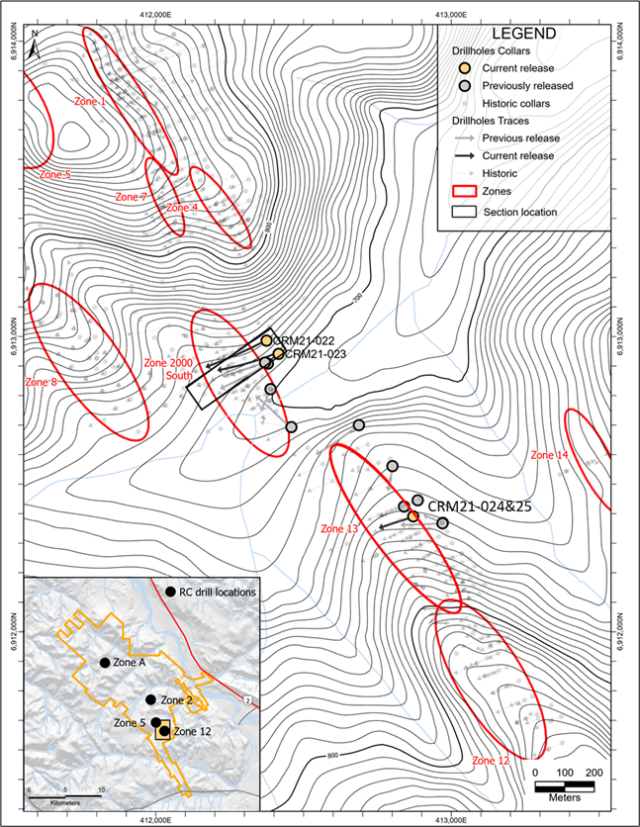
The objective of the Phase 2 RC program was early-stage evaluation of additional targets adjacent to known zones as well as step-out drilling at Carmacks Norths’ Zone A area. The program was successful in identifying mineralization in 13 of 20 holes with several areas prioritized for follow-up diamond drilling in the 2022 field season. The Phase 3 diamond program was targeted at confirming the geometry in Zone 2000S, complementing hole CRM21-011 which intercepted 105 m of 1.18% Copper Equivalent (“CuEq”) (0.96% Cu, 0.01% Mo, 0.18 g/t Au, and 4.06 g/t Ag) (see news release dated August 24, 2021). Additional drilling was conducted in the central portion of Zone 13 to further upgrade resources in this zone (Figure 1).

Granite Creek President & CEO, Tim Johnson, commented, “We are extremely pleased with the results of our 2021 exploration program which achieved all of our objectives and exceeded our expectations in several important respects. We expanded sulfide mineralization in three of the main zones at Carmacks which will be reflected in an updated NI 43-101 resource estimate, followed by a new mine plan which is being developed to incorporate both oxide and sulfide material. We anticipate the sulfide resources could make a significant difference to the mine life and economics of the Carmacks deposit and we look forward to further defining that potential.”

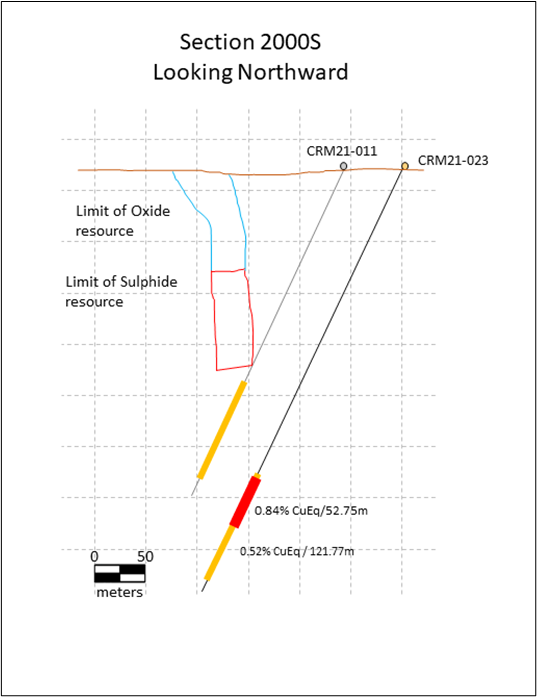
The results of Phase 3 have highlighted the predictable geometry of zone 2000S (see Figure 2). Both drillholes intersected mineralization well below the current sulphide resource1,2, with drill hole CRM21-023 intersecting mineralization approximately 120 meters below the base of the inferred sulphide resource and extending through to approximately 230 m below the base of the current inferred sulphide resource. Two holes drilled in Zone 13 continue to highlight the potential of this zone with CRM21-025 intercepting 120.65 m grading 0.76% Cu, 0.016% Mo, 0.14 g/t Au, 2.53g/t Ag or 0.94% CuEq. These 2021 drill campaign results will be incorporated into an updated National Instrument 43-101 resource estimate being prepared by SGS Canada.

DrillholeFrom(m)To(m)Length*(m)Cu(%)Mo(%)Au(g/t)Ag(g/t)CuEq** (%)Zone
CRM21-022233.70302.0068.30.510.0090.132.300.662000S
CRM21-023324.23446.00121.770.390.0070.131.760.52
Including330.00382.7552.750.630.0090.212.740.84
CRM21-02454.8093.0038.200.790.0050.163.270.9513
Including64.0077.0013.001.470.0060.235.851.71
CRM21-024106.50158.7052.200.260.0100.061.010.34
Including134.00149.0015.000.360.0210.081.280.51
CRM21-02588.65209.30120.650.760.0160.142.530.94
Including106.00155.4049.401.080.0150.203.411.31
CRM21-025283.75287.854.101.760.0140.147.991.99

Table 1- Highlights from of 2021 Phase 3 Diamond Drilling

** Copper equivalent (Cu Eq) values assume Cu $3.35/lb, Au $1600/oz, Ag $24/oz, Mo $12/lb and 100% recovery. *Weighted average intercepts shown. Estimated true widths vary but, based on geological interpretation of cross-sections, are estimated to be typically 40-60% of the intersected widths.

Figure 1: Location of diamond and RC drilling in this release

Figure 2: Cross section through 2000S with deepest intercept (CRM21-023)

The phase 2 RC drilling was conducted in Zones 2, 5, 12 at Carmacks and Zone A at Carmacks North. The purpose of the program was to test zones peripheral to the deposit and find targets for follow up with the diamond drill. The program was most successful in Zone 5 where 4 of 4 holes intersected mineralization and, consequently, Zone 5 will be a priority for drilling in 2022. The program was also successful in Zone 12 where it was used to trace and test mineralization on the west side of the zone that is not included in the 2016 resource estimate. Six of seven holes in zone 12 intersected mineralization. At Zone 2, mineralization was intersected in 2 of 6 holes.

At Zone A, the drill was used to test geophysical targets, but the program was cut short due to drilling difficulties. One of the 3 holes intersected mineralization but the other two did not reach target depth due to difficult drilling conditions.

Table 1: Selected highlights from previously released 2020 and 2021 drillholes

Drillhole
From(m)To(m)Length*(m)Cu(%)Mo(%)Au(g/t)Ag(g/t)CuEq** (%)Zone
CRM21-004323.50367.0043.501.120.0280.203.411.401
Including338.50367.0028.501.570.0420.294.531.96
and including352.00&dagger;367.0015.001.800.0660.334.812.31
CRM21-014355.70423.4567.750.930.0090.265.161.20
Including398.00423.4524.451.530.0090.416.211.91
CRM21-019277.95345.3067.350.930.0110.314.231.23
Including322.00345.3023.301.70.0160.577.512.27
CRM21-005137.05179.8043.240.740.0470.163.821.062000S
Including142.05158.4016.351.200.0360.266.111.58
CRM21-006194.40278.2083.800.640.0120.133.230.81
Including229.20278.2049.000.870.0180.173.881.10
Including248.76266.2017.441.210.0330.225.111.53
CRM21-011223.98329.50105.520.960.0130.184.061.18
Including223.98245.2021.222.170.0100.369.132.56
and including260.32260.820.5018.970.0080.4638.319.72
CRM20-001102.85230.12127.270.610.0280.1312.140.8513
Including104.85133.5028.651.030.0140.143.091.28
CRM21-021132.15229.0096.850.620.0140.203.040.84
Including132.15168.0035.850.820.0130.203.801.04
and including207.65229.0021.350.800.0210.433.511.21

[1] JDS Energy and Mining. Feb 9, 2017. NI 43-101 Preliminary Economic Assessment Technical Report on the Carmacks Project, Yukon, Canada. Contained metal based on 23.76 million tonnes of NI 43-101 compliant resources in the Measured and Indicated categories grading 0.85% Cu, 0.31 g/t Au, 3.14 g/t Ag.

[2] Arseneau Consulting Services, 2016 Independent Technical Report on the Carmacks Copper Project, Yukon, Canada.

About Granite Creek Copper

Granite Creek, a member of the Metallic Group of Companies, is a Canadian exploration company focused on the 176 square kilometer Carmacks project in the Minto copper district of Canada’s Yukon Territory. The project is on trend with the high-grade Minto copper-gold mine, operated by Minto Explorations Ltd, to the north and features excellent access to infrastructure with the nearby paved Yukon Highway 2, along with grid power within 12 km. More information about Granite Creek Copper can be viewed on the Company’s website at www.gcxcopper.com.

FOR FURTHER INFORMATION PLEASE CONTACT:

Timothy Johnson, President & CEO

Telephone: 1 (604) 235-1982

Toll Free: 1 (888) 361-3494

E-mail: info@gcxcopper.com

Website: www.gcxcopper.com

Qualified Person

Ms. Debbie James, P.Geo., a qualified person for the purposes of National Instrument 43-101, has reviewed and approved the technical disclosure contained in this news release. Ms. James is a Senior Geologist with TruePoint Exploration and the Project Manager for the Carmacks Project.

Quality Control and Quality Assurance

Quality assurance and quality control procedures include the systematic insertion of duplicate, blank and standard samples, making up 12% of the sample stream. Drill core samples were sawn in half, labelled, placed in sealed bags and shipped directly to the Bureau Veritas preparation laboratory in Whitehorse. All geochemical analyses were performed by Bureau Veritas in Vancouver. Copper and silver analysis was performed by four-acid digestion with an ICP-ES finish. Non-sulphide copper was determined through a sulphuric acid leach with an AAS finish. Gold was analyzed by igniting a 15 g sample followed by an aqua regia digestion with an ICP-MS finish.

Forward-Looking Statements

This news release includes certain statements that may be deemed “forward-looking statements”. All statements in this release, other than statements of historical facts including, without limitation, statements regarding potential mineralization, historic production, estimation of mineral resources, the realization of mineral resource estimates, interpretation of prior exploration and potential exploration results, the timing and success of exploration activities generally, the timing and results of future resource estimates, permitting time lines, metal prices and currency exchange rates, availability of capital, government regulation of exploration operations, environmental risks, reclamation, title, and future plans and objectives of the company are forward-looking statements that involve various risks and uncertainties. Although Granite Creek Copper believes the expectations expressed in such forward-looking statements are based on reasonable assumptions, such statements are not guarantees of future performance and actual results or developments may differ materially from those in the forward-looking statements. Forward-looking statements are based on a number of material factors and assumptions. Factors that could cause actual results to differ materially from those in forward-looking statements include failure to obtain necessary approvals, unsuccessful exploration results, changes in project parameters as plans continue to be refined, results of future resource estimates, future metal prices, availability of capital and financing on acceptable terms, general economic, market or business conditions, risks associated with regulatory changes, defects in title, availability of personnel, materials and equipment on a timely basis, accidents or equipment breakdowns, uninsured risks, delays in receiving government approvals, unanticipated environmental impacts on operations and costs to remedy same, and other exploration or other risks detailed herein and from time to time in the filings made by the companies with securities regulators. Readers are cautioned that mineral resources that are not mineral reserves do not have demonstrated economic viability. Mineral exploration and development of mines is an inherently risky business. Accordingly, the actual events may differ materially from those projected in the forward-looking statements. For more information on Granite Creek Copper and the risks and challenges of their businesses, investors should review their annual filings that are available at www.sedar.com.

Neither the TSX Venture Exchange nor its Regulation Services Provider (as that term is defined in the policies of the TSX Venture Exchange) accepts responsibility for the adequacy or accuracy of this release.

SOURCE: Granite Creek Copper Ltd.


View source version on accesswire.com:
https://www.accesswire.com/692471/Granite-Creek-Copper-Reports-Final-Results-2021-Drill-Program-Including-12065m-at-094-Copper-Equivalent-at-the-Carmacks-Copper-Gold-Silver-Project-in-Yukon-Canada

Categories
Base Metals Breaking Energy Junior Mining Precious Metals

Group Ten Reports High-Grade Drill Results Spanning Seven Kilometers at Stillwater West, Demonstrating Significant Potential for Expansion of Critical Mineral Resources in Montana, USA

VANCOUVER, BC / ACCESSWIRE / March 7, 2022 / Group Ten Metals Inc. (TSX.V:PGE; OTCQB:PGEZF; FSE:5D32) (the “Company” or “Group Ten”) today reports partial results from four drill holes in a second tranche of drill results from the 14-hole resource expansion campaign completed at the Company’s flagship Stillwater West PGE-Ni-Cu-Co + Au project in Montana, USA.

Results continue to support the Company’s priority objective of expanding the October 2021 inaugural mineral resource estimates, with multiple wide and highly mineralized intervals returned in step-out drilling at three deposit areas that span seven kilometers of the 12-kilometer core project area (see Figure 1). Mineralization remains open to expansion along trend and at depth in all deposit areas.

2021 Drill Highlights:

  • IM2021-04 returned 115 meters of 0.37% Nickel Equivalent (“NiEq”), or 0.98 g/t Palladium Equivalent (“PdEq”) in a step-out hole to the south of the HGR deposit area at Iron Mountain. Mineralization starts at surface and runs the entire length that has been assayed to date, returning 369 meters at 0.22% NiEq (0.60 g/t PdEq). Assays are pending from the bottom 53 meters of the 422-meter hole. As shown in Table 1, successive contained higher-grade intervals include:
    • 9.8 meters of 1.43 g/t 3E (Pd+Pt+Au) plus Ni, Cu, and Co values for total mineralization of 0.74% NiEq, or 1.98 g/t PdEq, and;
    • 4.8 meters of 1.35% NiEq (equal to 3.60 g/t PdEq) as 0.74% Ni, 0.65% Cu, 0.07% Co, and 0.24 g/t 3E.
  • CM2021-03 returned 0.24% NiEq (0.63 g/t PdEq) across its entire 428-meter length in step-out drilling in the DR and Hybrid deposit area, including contained intervals at higher grades:
    • 30.3 meters of 0.99 g/t 3E plus Ni, Cu, and Co values for a total of 0.51% NiEq, or 1.36 g/t PdEq;
    • 0.50% NiEq, or 1.34 g/t PdEq, over 9.2 meters, and;
    • 0.50% NiEq, or 1.34 g/t PdEq over 7.2 meters in a separate, lower interval.
  • CM2021-02 returned top-to-bottom mineralization with 333 meters at 0.23% NiEq, or 0.61 g/t PdEq, and successive higher-grade intervals including 17.0 meters of 0.51% NiEq (1.35 g/t PdEq).
  • These results, in addition to results released December 20, 2021, demonstrate significant potential to expand the October 2021 mineral resource estimates with multiple long intervals at grades well above the 0.20% NiEq cut-off grade used in that study. Moreover, as shown in Figures 2 and 3, these results provide important intercepts in step-out drill holes located up to several hundred meters from three of the five deposits modeled in the 2021 resource estimate:
    • CM2021-02 and -03 are two of six holes drilled in 2021 in the DR and Hybrid deposit area to step out from high-grade nickel sulphide-PGE mineralization identified in hole CM2020-04. In addition, these holes also returned potentially significant extensions of hybrid-type mineralization. Hole CM2021-01, reported December 20, 2021, was drilled south from the same pad as CM2021-02 and returned 728 meters of continuous sulphide mineralization at 0.27% NiEq, or 0.73 g/t PdEq, with multiple contained intervals at successively higher grades;
    • CZ2021-02 is one of two holes drilled in 2021 to step-out to the south of the CZ deposit in the area of wide, high-grade mineralization returned in hole CZ2019-01. Hole CZ2021-01, reported December 20, 2021, returned the widest high-grade intercept to date on the project being 63.7 meters of 0.92% NiEq (2.46 g/t PdEq) in this area;
    • IM2021-04 is one of six holes drilled in the HGR deposit area with the objective of expanding on wide intervals of high-grade mineralization returned in hole IM2019-03 which returned 272 meters at 0.43% NiEq (1.16 g/t PdEq) including 26.8 meters at 1.24 g/t 4E, 0.34% Ni, 0.15% Cu, and 0.019% Co, for 0.96% NiEq (2.55 g/t PdEq).
  • Assay results remain pending from eight holes, in addition to rhodium assay results on the majority of mineralized intervals reported to date.

Michael Rowley, President and CEO, commented, “The Stillwater Igneous Complex has been a large-scale American source of critical minerals for many decades, from chromium mined in the 1940s and 1950s to palladium and platinum that became essential in the 1980s. Our “Platreef-in-Montana” model is well-timed for what we believe will be the next phase of the Stillwater district’s contribution to critical mineral supply and commodity independence in the USA; world-class nickel and copper sulphide deposits, enriched in palladium, platinum, rhodium, gold, and cobalt and hosted in the lower Stillwater complex at Stillwater West.”

“This second tranche of drill results from our resource expansion campaign builds nicely upon the first results and continues to advance us towards expanded resource estimates in three of the five deposit areas on a priority basis. We continue to see demonstrations of a large mineralized system with an impressive endowment of eight of the commodities listed as critical by the US government in numerous holes across the 12-kilometer core project area. In addition, we continue to see good optionality on possible mining methods with successively higher-grade intervals contained within wider intervals of hundreds of meters of lower grade mineralization. We look forward to reporting additional drill results, exploration plans for 2022, and other news in the near term.”

Table 1 – Highlight Results from 2021 Expansion Drill Campaigns at the DR, Hybrid, CZ, and HGR Deposit Areas

Assays pending for rhodium and certain intervals denoted by *. Highlighted significant intercepts with grade-thickness values over 20 gram-meter PdEq are presented above, except as noted. Grade thickness values cover significant mineralized intervals with total palladium and nickel equivalent grade-thickness determined by multiplying the thickness of continuous mineralization (in meters) by the palladium equivalent grade (in grams/tonne) to provide gram-meter values (g-m) or by multiplying the nickel equivalent grade (in percent) to provide percent-meter values as shown. Total nickel and palladium equivalent calculations reflect total gross metal content using metals prices as follows (all USD): $7.00/lb nickel (Ni), $3.50/lb copper (Cu), $20.00/lb cobalt (Co), $1,000/oz platinum (Pt), $1,800/oz palladium (Pd), and $1,600/oz gold (Au). Equivalent values have not been adjusted to reflect metallurgical recoveries. Total metal equivalent values include both base and precious metals. In terms of dollar value, 0.20% nickel equates to a copper value of 0.40%, or a palladium value of 0.53 g/t, using the above metal values. Intervals are reported as drilled widths and are believed to be representative of the actual width of mineralization.

Upcoming News and Events

Jeffrey Christian, Managing Director of CPM Group, will join Group Ten CEO Michael Rowley for a live webinar on March 8, 2022, at 10:00 am PT (1:00 pm ET) for a concise overview and update on the Company and the Stillwater West PGE-Ni-Cu-Co+Au project with in-depth discussion on the global macro-economic picture, trends and implications for the broader commodities sector and critical minerals, in particular.

This will be an interactive event with participants encouraged to submit questions and comments throughout.

To register, click here or the graphic below.

About Stillwater West

Group Ten is rapidly advancing the Stillwater West PGE-Ni-Cu-Co + Au project towards becoming a world-class source of low-carbon, sulphide-hosted nickel, copper, and cobalt, critical to the electrification movement, as well as key catalytic metals including platinum, palladium and rhodium used in catalytic converters, fuel cells, and the production of green hydrogen. Stillwater West positions Group Ten as the second-largest landholder in the Stillwater Complex, with a 100%-owned position adjoining and adjacent to Sibanye-Stillwater’s PGE mines in south-central Montana, USA1. The Stillwater Complex is recognized as one of the top regions in the world for PGE-Ni-Cu-Co mineralization, alongside the Bushveld Complex and Great Dyke in southern Africa, which are similar layered intrusions. The J-M Reef, and other PGE-enriched sulphide horizons in the Stillwater Complex, share many similarities with the highly prolific Merensky and UG2 Reefs in the Bushveld Complex. Group Ten’s work in the lower Stillwater Complex has demonstrated the presence of large-scale disseminated and high-sulphide battery metals and PGE mineralization, similar to the Platreef in the Bushveld Complex2. Drill campaigns by the Company, complemented by a substantial historic drill database, have delineated five deposits of Platreef-style mineralization across a core 12-kilometer span of the project, all of which are open for expansion into adjacent targets. Multiple earlier-stage Platreef-style and reef-type targets are also being advanced across the remainder of the 32-kilometer length of the project based on strong correlations seen in soil and rock geochemistry, geophysical surveys, geologic mapping, and drilling.

About Group Ten Metals Inc.

Group Ten Metals Inc. is a TSX-V-listed Canadian mineral exploration company focused on the development of high-quality platinum, palladium, nickel, copper, cobalt, and gold exploration assets in top North American mining jurisdictions. The Company’s core asset is the Stillwater West PGE-Ni-Cu-Co + Au project adjacent to Sibanye-Stillwater’s high-grade PGE mines in Montana, USA. Group Ten also holds the high-grade Black Lake-Drayton Gold project adjacent to Treasury Metals’ development-stage Goliath Gold Complex in northwest Ontario, and the Kluane PGE-Ni-Cu-Co project on trend with Nickel Creek Platinum‘s Wellgreen deposit in Canada‘s Yukon Territory.

About the Metallic Group of Companies

The Metallic Group is a collaboration of leading precious and base metals exploration companies, with a portfolio of large, brownfield assets in established mining districts adjacent to some of the industry’s highest-grade producers of silver and gold, platinum and palladium, and copper. Member companies include Metallic Minerals in the Yukon’s high-grade Keno Hill silver district and La Plata silver-gold-copper district of Colorado, Group Ten Metals in the Stillwater PGM-nickel-copper district of Montana, and Granite Creek Copper in the Yukon’s Minto copper district. The founders and team members of the Metallic Group include highly successful explorationists formerly with some of the industry’s leading explorers/developers and major producers. With this expertise, the companies are undertaking a systematic approach to exploration using new models and technologies to facilitate discoveries in these proven, but under-explored, mining districts. The Metallic Group is headquartered in Vancouver, BC, Canada, and its member companies are listed on the Toronto Venture, US OTC, and Frankfurt stock exchanges.

Note 1: References to adjoining properties are for illustrative purposes only and are not necessarily indicative of the exploration potential, extent or nature of mineralization or potential future results of the Company’s projects.

Note 2: Magmatic Ore Deposits in Layered Intrusions-Descriptive Model for Reef-Type PGE and Contact-Type Cu-Ni-PGE Deposits, Michael Zientek, USGS Open-File Report 2012-1010.

FOR FURTHER INFORMATION, PLEASE CONTACT:

Michael Rowley, President, CEO & Director
Email: info@grouptenmetals.com Phone: (604) 357 4790
Web: http://grouptenmetals.com Toll Free: (888) 432 0075

Quality Control and Quality Assurance

2021 drill core samples were analyzed by ACT Labs in Vancouver, B.C. Sample preparation: crush (< 7 kg) up to 80% passing 2 mm, riffle split (250 g) and pulverize (mild steel) to 95% passing 105 µm included cleaner sand. Gold, platinum, and palladium were analyzed by fire assay (1C-OES) with ICP finish. Selected major and trace elements were analyzed by peroxide fusion with 8-Peroxide ICP-OES finish to insure complete dissolution of resistate minerals. Following industry QA/QC standards, blanks, duplicate samples, and certified standards were also assayed.

Mr. Mike Ostenson, P.Geo., is the qualified person for the purposes of National Instrument 43-101, and he has reviewed and approved the technical disclosure contained in this news release.

Forward-Looking Statements

Forward Looking Statements: This news release includes certain statements that may be deemed “forward-looking statements”. All statements in this release, other than statements of historical facts including, without limitation, statements regarding potential mineralization, historic production, estimation of mineral resources, the realization of mineral resource estimates, interpretation of prior exploration and potential exploration results, the timing and success of exploration activities generally, the timing and results of future resource estimates, permitting time lines, metal prices and currency exchange rates, availability of capital, government regulation of exploration operations, environmental risks, reclamation, title, and future plans and objectives of the company are forward-looking statements that involve various risks and uncertainties. Although Group Ten believes the expectations expressed in such forward-looking statements are based on reasonable assumptions, such statements are not guarantees of future performance and actual results or developments may differ materially from those in the forward-looking statements. Forward-looking statements are based on a number of material factors and assumptions. Factors that could cause actual results to differ materially from those in forward-looking statements include failure to obtain necessary approvals, unsuccessful exploration results, changes in project parameters as plans continue to be refined, results of future resource estimates, future metal prices, availability of capital and financing on acceptable terms, general economic, market or business conditions, risks associated with regulatory changes, defects in title, availability of personnel, materials and equipment on a timely basis, accidents or equipment breakdowns, uninsured risks, delays in receiving government approvals, unanticipated environmental impacts on operations and costs to remedy same, and other exploration or other risks detailed herein and from time to time in the filings made by the companies with securities regulators. Readers are cautioned that mineral resources that are not mineral reserves do not have demonstrated economic viability. Mineral exploration and development of mines is an inherently risky business. Accordingly, the actual events may differ materially from those projected in the forward-looking statements. For more information on Group Ten and the risks and challenges of their businesses, investors should review their annual filings that are available at www.sedar.com.

Neither the TSX Venture Exchange nor its Regulation Services Provider (as that term is defined in the policies of the TSX Venture Exchange) accepts responsibility for the adequacy or accuracy of this release.

SOURCE: Group Ten Metals Inc.


View source version on accesswire.com:
https://www.accesswire.com/691772/Group-Ten-Reports-High-Grade-Drill-Results-Spanning-Seven-Kilometers-at-Stillwater-West-Demonstrating-Significant-Potential-for-Expansion-of-Critical-Mineral-Resources-in-Montana-USA

Categories
Base Metals Breaking Energy Exclusive Interviews Junior Mining Precious Metals

Millrock – Nikolia Project, Loaded with Battery Metals, Platinum Group Elements

PARTNERING THE MOST HIGH RISK, HIGH-COST STAGES OF EXPLORATION Millrock (TSX.V: MRO.V) is a project generator company focused on the discovery and development of high-value metallic mineral deposits in two jurisdictions with outstanding potential: the State of Alaska and Mexico – primarily the state of Sonora. The company’s main emphasis has been on gold and copper, focusing on porphyry and high-grade vein style deposits. Our objective is to discover a world-class ore body, building further shareholder value through the exploration and development of existing projects and exploration joint ventures.

Millrock Resouces (TSX.V: MRO | OTCQX: MLRKF) Website: www.millrockresources.com Corporate Presentation: https://www.millrockresources.com/investors/corporate-presentation

Categories
Base Metals Energy Junior Mining

Eloro Resources Intersects 171.57 g Ag eq/t (12.04 g Ag/t, 0.29% Zn, 0.22% Pb and 0.22% Sn) over 373.40m in Southern Part of Santa Barbara Target at Iska Iska Silver-Tin Polymetallic Project, Potosi Department, Bolivia

Eloro Resources Ltd.

Figure 1

Geology of the Iska Iska Caldera Complex showing locations of Major Breccia Pipe targets, the Santa Barbara Resource Definition Target Zone and diamond drill holes completed and planned.

Figure 2

Preliminary W-E Geological Cross Section with Drill Hole DSBU-03 (looking north)

Figure 3

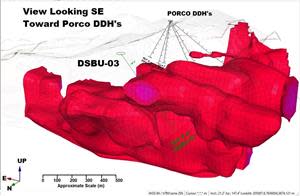
3D Inverse Magnetic Susceptibility Model Showing How Hole DSBU-03 Intersected the Northern tip of this Massive Anomaly that extends to the Southeast from the Santa Barbara area to beneath the Porco area.
  • Includes higher-grade sections of 401.81 g Ag eq/t (31.46 g Ag/t, 0.19 %Pb and 0.61 %Sn) over 28.58m from 192.72m to 221.30m, 261.83 g Ag eq/t (4.91 g Ag/t and 0.43% Sn) over 95.16m in underground drill hole DSBU-03.
  • Deeper in this hole, an additional major intersection of 197.61 g Ag /t (1.79 g Ag/t and 0.28% Sn) over 60.50m was encountered from 418.80m to 479.30m.
  • In order to more aggressively drill this major new extension of the Santa Barbara deposit, a third surface diamond drill is being brought onto site bringing the total operating drills to four (3 surface and 1 underground).

TORONTO, March 01, 2022 (GLOBE NEWSWIRE) — Eloro Resources Ltd. (TSX-V: ELO; OTCQX: ELRRF; FSE: P2QM) (“Eloro”, or the “Company”) is pleased to announce assay results from an additional diamond drill hole from its on-going drilling program at the Iska Iska silver-tin polymetallic project in the Potosi Department, southern Bolivia. Hole DSBU-03, an underground hole drilled due west from the Santa Barbara adit at -50 degrees, has discovered major new depth extensions of the already large Santa Barbara mineralized zones.

The Company has completed 45,779m in 81 drill holes, including three holes in progress as shown in Figure 1. Table 1 lists significant assay results. Prices used for calculating Ag equivalent grades are as outlined in Eloro’s February 1, 2022, press release. Table 2 summarizes drill holes with assays pending. Highlights are as follows:

Underground Metallurgical Hole, Santa Barbara Mineral Resource Target Area

Underground hole DSBU-03, collared in the Santa Barbara adit and drilled at an azimuth of 270 degrees at -50 degrees dip, intersected significant mineralization including substantial tin suggesting proximity to a major intrusive source (Figures 1, 2 and 3 and Table 1):

  • 171.57 g Ag eq/t (12.04 g Ag/t, 0.29% Zn, 0.22% Pb and 0.22% Sn) over 373.40m from 0.00m to 373.40m Including higher-grade sections of 401.81 g Ag eq/t (31.46 g Ag/t, 0.19 %Pb and 0.61 %Sn) over 28.58m from 192.72m to 221.30m and 261.83 g Ag eq/t (4.91 g Ag/t and 0.43% Sn) over 95.16m from 272.27m to 367.41m.
  • The first higher-grade interval above includes the highest single Sn grade sample yet encountered at Iska Iska at 4.1% Sn over 1.47m.
  • Deeper in this hole, an additional major intersection of 197.61 g Ag /t (1.79 g Ag/t and 0.28% Sn) over 60.50m was encountered from 418.80m to 479.30m.
  • This drill hole intersected the northern tip of an extensive 3D inverse magnetic susceptibility anomaly that extends from the Santa Barbara area southeastwards beneath Porco as shown in Figure 3. The southern part of this anomaly in the Porco area may reflect a deeper porphyry Sn intrusion and will be drill tested shortly.

Tom Larsen, CEO of Eloro, commented: “This new underground hole is the longest and highest-grade intersection obtained thus far in our diamond drill program and further highlights the major potential of the Santa Barbara target area to host significant higher-grade mineral resources, especially with tin. In order to more aggressively drill this major new extension of the Santa Barbara deposit, a third surface diamond drill is being brought onto site bringing the total operating drills to four (3 surface and 1 underground).

Dr. Bill Pearson, P.Geo., Eloro’s Executive Vice President Exploration, added: “The 3D inverse magnetic susceptibility model is proving to be an important indicator for targeting areas of potential tin mineralization at depth. Work by Dr. Arce and his geological team indicates that in deeper levels tin occurs as cassiterite associated with pyrrhotite which is magnetic. Tin at higher levels is associated with silver, which likely has been remobilized, and generally occurs with pyrite that is non-magnetic.” “In addition to the outstanding drill results, work is moving forward on the metallurgical testing with Blue Coast Research Ltd. We are also working closely with Micon International Limited to develop appropriate parameters for the mineral resource estimation. The bore hole induced polarization program is continuing with additional holes being surveyed to expand our coverage and determine the continuity of mineralization between drill holes. The GeologicAI scanner is expected to be on site and fully operational by the end of March.”

Dr. Osvaldo Arce, P.Geo., General Manager of Eloro’s Bolivian subsidiary Minera Tupiza S.R.L. (“Minera Tupiza”), further commented: “At Iska Iska we are rapidly defining a massive porphyry-epithermal silver-tin polymetallic mineralized system. The grade and extent of tin mineralization increases considerably with depth which is typical of the deeper parts of tin porphyries in Bolivia. Superimposed on this extensive tin porphyry system is a higher-level silver-zinc-lead epithermal mineralized system that is principally hosted in the major breccia pipes and intensely fractured dacitic domes surrounding these breccia pipes.”

“The entire package has been subjected to later deformation and remobilization which has substantially altered many of the primary relationships. The southern area of Santa Barbara where we already have two impressive holes with 300m+ long intersections and southeast to the Porco area appears to be the potential centre of the porphyry-epithermal system. We are now on our 81st hole and all holes reported to date have multiple reportable intersections, which is remarkable. The system remains open along strike to the northwest and to the southeast. Geological mapping and diamond drilling suggest that the potential strike length of the entire system may be as much as 4km, the width up to 2km, with a depth extent of 1km or more.”

Table 1: Significant Results, Diamond Drilling, Santa Barbara Resource Definition Target Area as at March 1, 2022.

SANTA BARBARA RESOURCE DEFINITION TARGET ZONE
UNDERGROUND DRILL HOLE
Hole No.From (m)To (m)Length (m)AgAuZnPbCuSnBiCdAg eq
g/tg/t%%%%%%g/t
DSBU-030.00373.38373.4012.040.060.290.220.030.220.0030.007171.57
Incl.192.72221.328.5831.460.050.010.190.020.610.0030.005401.81
Incl.272.27367.4195.164.910.010.010.020.010.430.0010.005261.83
391.22395.834.611.000.010.010.020.010.160.0010.00598.99
418.80479.360.501.790.050.020.060.090.280.0830.005197.61
493.11494.611.503.000.450.010.000.010.150.0010.005129.35
514.30515.721.428.000.210.010.100.070.110.0340.005110.16
520.24524.764.533.670.020.000.010.110.090.0270.00579.57
547.40560.8513.454.570.100.010.030.120.050.0450.00569.80
578.90581.832.931.500.260.010.000.080.030.0010.00554.94
599.90601.451.553.000.780.010.020.100.090.0290.005139.37
614.97617.973.001.970.040.010.020.510.070.0090.005115.65
625.41631.416.001.000.040.010.030.400.000.0010.00561.52

Note: True width of the mineralization is not known at the present time, but based on the current understanding of the relationship between drill orientation/inclination and the mineralization within the breccia pipes and the host rocks such as sandstones and dacites, it is estimated that true width ranges between 70% and 90% of the down hole interval length but this will be confirmed by further drilling and geological modelling.

Chemical symbols: Ag= silver, Au = gold, Zn = zinc, Pb = lead, Cu = copper, Sn = tin, Bi = bismuth, Cd = cadmium and g Ag eq/t = grams silver equivalent per tonne. Quantities are given in percent (%) for Zn, Pb Cu, Sn, Bi and Cd and in grams per tonne (g/t) for Ag, Au and Ag eq.

Metal prices and conversion factors used for calculation of g Ag eq/t (grams Ag per grams x metal ratio) are as follows (Prices updated as of February 1, 2022, to more accurately reflect current metal prices):

ElementPrice $US (per kg)Ratio to Ag
Ag$722.561.0000
Sn$42.560.0589
Zn$3.300.0046
Pb$2.330.0032
Au$57,604.0079.7221
Cu$9.680.0134
Bi$12.760.0177
Cd$5.500.0076

In calculating the intersections reported in this press release a sample cutoff of 30 g Ag eq/t was used with generally a maximum dilution of 3 continuous samples below cutoff included within a mineralized section unless more dilution is justified geologically.

The equivalent grade calculations are based on the stated metal prices and are provided for comparative purposes only, due to the polymetallic nature of the deposit. Metallurgical tests are in progress by Blue Coast Ltd. to establish levels of recovery for each element reported but currently the potential recovery for each element has not yet been established. While there is no assurance that all or any of the reported concentrations of metals will be recoverable, Bolivia has a long history of successfully mining and processing similar polymetallic deposits which is well documented in the landmark volume “Yacimientos Metaliferos de Bolivia” by Dr. Osvaldo R. Arce Burgoa, P.Geo.

Table 2: Summary of Diamond Drill Holes Completed with Assays Pending and Drill Holes in Progress at Iska Iska from March 1, 2022 press release.

Hole No.TypeCollar EastingCollar NorthingElevAzimuthAngleHole Length m
Surface Drilling Northwest Extension Santa Barbara
DSB-14S205283.07656587.24175.0225-65968.5
DSB-16S204973.17657053.84165.0225-65862.0
DSB-17S7656765.4205131.34173.0225-40841.0
DSB-18S7656676.3205207.14175.0225-40890.4
DSB-19S7656676.3205207.14175.0225-65803.3
DSB-22S7657208.4204799.44145.0225-40258.4
DSB-23S205341.07656535.04177.0225-40661.3
DSB-24S205341.07656535.04177.0225-65343.4
DSB-25S205283.07656587.24175.0225-40615.3
DSB-26S205044.57656982.64150.0225-40815.4
DSB-27S205044.57656982.64150.0225-65800.4
Subtotal7859.4
Underground Drilling Santa Barbara Adit
DSBU-4UG205285.27656074.84165.0180-20570.0
DSBU-5UG205285.27656074.84165.00-40491.7
DSBU-6UG205285.27656074.84165.00-65253.5
DSBU-7UG205284.57656080.04167.1235-50800.9
Subtotal2116.1
DSBU-8UG205284.57656080.04167.1200-50In progress
Underground Metallurgical Drill Holes Santa Barbara
METSBU-01UG205285.27656074.84165.010-35351.0
Subtotal351.0
Surface Drilling South Extension Santa Barbara
DSBS-01S205300.07655563.04204.030°-30700.8
Subtotal700.8
DSBS-02S205300.07655563.04204.00°-45In progress
Porco Target Area – Surface Drill Program
DPC-04S205457.27655110.94175.00-60371.4
DPC-05S205457.27655110.94175.090-60407.5
DPC-06S205457.27655110.94175.0243-60716.4
DPC-08S205456.27655113.44175.9243-60800.4
Subtotal2295.7
DPC-07S205090.07655343.74310.0235-65In progress
TOTAL13,323

S = Surface UG=Underground; collar coordinates in metres; azimuth and dip in degrees. Total drilling completed since the start of the program on September 13, 2020 to December 17, 2021 is 40,468 m in 73 holes (26 underground holes and 47 surface holes). From re-start of drilling on January 17, 2022, an additional 5,311m has been completed bringing the overall total to 45,779m in 81 drill holes (27 underground drill holes and 54 surface drill holes) including 3 holes in progress.

Figure 1: Geology of the Iska Iska Caldera Complex showing locations of Major Breccia Pipe targets, the Santa Barbara Resource Definition Target Zone and diamond drill holes completed and planned.
https://www.globenewswire.com/NewsRoom/AttachmentNg/c76d310b-6996-445f-b60c-372aef74d01f

Figure 2: Preliminary W-E Geological Cross Section with Drill Hole DSBU-03 (looking north)
https://www.globenewswire.com/NewsRoom/AttachmentNg/abe4a4b7-49af-4c5f-b33e-951ce8e2f5fd

Figure 3: 3D Inverse Magnetic Susceptibility Model Showing How Hole DSBU-03 Intersected the Northern tip of this Massive Anomaly that extends to the Southeast from the Santa Barbara area to beneath the Porco area.
https://www.globenewswire.com/NewsRoom/AttachmentNg/389e27fe-e2aa-4157-bb36-ea1723bfed63

Qualified Person

Dr. Osvaldo Arce, P. Geo., General Manager of Minera Tupiza, and a Qualified Person in the context of NI 43-101, has reviewed and approved the technical content of this news release. Dr. Bill Pearson, P.Geo., Executive Vice President Exploration Eloro, and who has more than 45 years of worldwide mining exploration experience including extensive work in South America, manages the overall technical program working closely with Dr. Osvaldo Arce, P.Geo., Manager of Minera Tupiza. Dr. Quinton Hennigh, P.Geo., Senior Technical Advisor to Eloro and Independent Technical Advisor, Mr. Charley Murahwi P. Geo., FAusIMM of Micon International Limited are regularly consulted on technical aspects of the project.

The magnetic survey was carried out by MES Geophysics using a GEM Systems GSM-19W Overhauser magnetometer. Dr. Chris Hale, P.Geo. and Mr. John Gilliatt, P.Geo. of Intelligent Exploration provided the survey design, preparation of the maps and interpretation from data processed and quality reviewed by Rob McKeown, P. Geo. of MES Geophysics. Messrs. Hale, Gilliatt and McKeown are Qualified Persons as defined under NI 43-101 Mr. Joe Mihelcic, P.Eng., P.Geo., a QP under NI 43-101, of Clearview Geophysics completed the 3D magnetic inversion model in consultation with Dr. Chris Hale, P.Geo. and Mr. John Gilliatt, P.Geo. of Intelligent Exploration.

Eloro is utilizing both ALS and AHK for drill core analysis, both of whom are major international accredited laboratories. Drill samples sent to ALS are prepared in both ALS Bolivia Ltda’s preparation facility in Oruro, Bolivia and the preparation facility operated by AHK in Tupiza with pulps sent to the main ALS Global laboratory in Lima for analysis. More recently Eloro has had ALS send pulps to their laboratory at Galway in Ireland. Eloro employs an industry standard QA/QC program with standards, blanks and duplicates inserted into each batch of samples analyzed with selected check samples sent to a separate accredited laboratory.

Drill core samples sent to AHK Laboratories are prepared in a preparation facility installed and managed by AHK in Tupiza with pulps sent to the AHK laboratory in Lima, Peru. Au and Sn analysis on these samples is done by ALS Bolivia Ltda in Lima. Check samples between ALS and AHK are regularly done as a QA/QC check. AHK is following the same analytical protocols used as with ALS and with the same QA/QC protocols. Turnaround time continues to improve and it is hoped that most of the sample backlog will be cleared in the next 4-6 weeks.

About Iska Iska

Iska Iska silver-tin polymetallic project is a road accessible, royalty-free property, wholly controlled by the Title Holder, Empresa Minera Villegas S.R.L. and is located 48 km north of Tupiza city, in the Sud Chichas Province of the Department of Potosi in southern Bolivia. Eloro has an option to earn a 99% interest in Iska Iska.

Iska Iska is a major silver-tin polymetallic porphyry-epithermal complex associated with a Miocene possibly collapsed/resurgent caldera, emplaced on Ordovician age rocks with major breccia pipes, dacitic domes and hydrothermal breccias. The caldera is 1.6km by 1.8km in dimension with a vertical extent of at least 1km. Mineralization age is similar to Cerro Rico de Potosí and other major deposits such as San Vicente, Chorolque, Tasna and Tatasi located in the same geological trend.

Eloro began underground diamond drilling from the Huayra Kasa underground workings at Iska Iska on September 13, 2020. On November 18, 2020, Eloro announced the discovery of a significant breccia pipe with extensive silver polymetallic mineralization just east of the Huayra Kasa underground workings and a high-grade gold-bismuth zone in the underground workings. On November 24, 2020, Eloro announced the discovery of the SBBP approximately 150m southwest of the Huayra Kasa underground workings.

Subsequently, on January 26, 2021, Eloro announced significant results from the first drilling at the SBBP including the discovery hole DHK-15 which returned 129.60 g Ag eq/t over 257.5m (29.53g Ag/t, 0.078g Au/t, 1.45%Zn, 0.59%Pb, 0.080%Cu, 0.056%Sn, 0.0022%In and 0.0064% Bi from 0.0m to 257.5m. Subsequent drilling has confirmed significant values of Ag-Sn polymetallic mineralization in the SBBP and the adjacent CBP. A substantive mineralized envelope which is open along strike and down-dip extends around both major breccia pipes. Continuous channel sampling of the Santa Barbara Adit located to the east of SBBP returned 442 g Ag eq/t (164.96 g Ag/t, 0.46%Sn, 3.46% Pb and 0.14% Cu) over 166m including 1,092 g Ag eq/t (446 g Ag/t, 9.03% Pb and 1.16% Sn) over 56.19m. The west end of the adit intersects the end of the SBBP.

Since the initial discovery hole, Eloro has released a number of significant drill results in the SBBP and the surrounding mineralized envelope which along with geophysical data has defined a target zone 1400m along strike, 500m wide and that extends to a depth of 600m. This zone is open along strike to the northwest and southeast as well as to the southwest. The Company’s nearer term objective is to outline a maiden NI 43-101 compliant mineral resource within this large target area. This work is advancing well with the mineral resource targeted to be completed in Q2 2022. Exploration drilling is also planned on other major targets in the Iska Iska Caldera Complex including the Porco and Mina 2 areas.

About Eloro Resources Ltd.

Eloro is an exploration and mine development company with a portfolio of gold and base-metal properties in Bolivia, Peru and Quebec. Eloro has an option to acquire a 99% interest in the highly prospective Iska Iska Property, which can be classified as a polymetallic epithermal-porphyry complex, a significant mineral deposit type in the Potosi Department, in southern Bolivia. Eloro commissioned a NI 43-101 Technical Report on Iska Iska, which was completed by Micon International Limited and is available on Eloro’s website and under its filings on SEDAR. Iska Iska is a road-accessible, royalty-free property. Eloro also owns an 82% interest in the La Victoria Gold/Silver Project, located in the North-Central Mineral Belt of Peru some 50 km south of Barrick’s Lagunas Norte Gold Mine and Pan American Silver’s La Arena Gold Mine. La Victoria consists of eight mining concessions and eight mining claims encompassing approximately 89 square kilometres. La Victoria has good infrastructure with access to road, water and electricity and is located at an altitude that ranges from 3,150 m to 4,400 m above sea level.

For further information please contact either Thomas G. Larsen, Chairman and CEO or Jorge Estepa, Vice-President at (416) 868-9168.

Information in this news release may contain forward-looking information. Statements containing forward-looking information express, as at the date of this news release, the Company’s plans, estimates, forecasts, projections, expectations, or beliefs as to future events or results and are believed to be reasonable based on information currently available to the Company. There can be no assurance that forward-looking statements will prove to be accurate. Actual results and future events could differ materially from those anticipated in such statements. Readers should not place undue reliance on forward-looking information.

Neither the TSXV nor its Regulation Services Provider (as that term is defined in the policies of the TSXV) accepts responsibility for the adequacy or accuracy of this release.